
| Characteristic | Value |
|---|---|
| CLIMB CLASS | traverse |
| CLIMB AREA | Western Caucasus, Arkhyz, northern spur of the Sofiyskiy ridge between the valleys of the Psyysh and Sofiya rivers |
| PEAK ROUTE | 60 let KChAO, Peshtera, Septemvri (proposed by the first ascenders), Kelbashi |
| ASSUMED DIFFICULTY CATEGORY | 3A (winter) |
| ROUTE DESCRIPTION | – Rock and snow, mostly ridge, absolute altitude difference 643 m |
| NUMBER OF PITOONS | 12 |
| NUMBER OF TRAVERSE HOURS | 12 hours (from the start of the route to the summit of Kelbashi) |
| NUMBER OF OVERNIGHTS | not required on the route |
| CLIMB LEADER | Chuenko S.A. – CMS, instructor |
| PARTICIPANTS | – Tretyakov V.N., – Tr., instructor, Belokurov I.L. – Pr., Gavrilov I.V. – Pr. |
| TEAM COACH | – MS of the USSR Popov V.L. |
| DATE OF DEPARTURE ON THE ROUTE AND RETURN | January 13, 1982 |
The traverse was made along the NE ridge of peak 60 let KChAO, climbed on January 8, 1982, NW ridge of v. Peshtera, climbed on January 9, 1982, NE ridge of v. 3100 and the Northern ridge of v. Kelbashi.
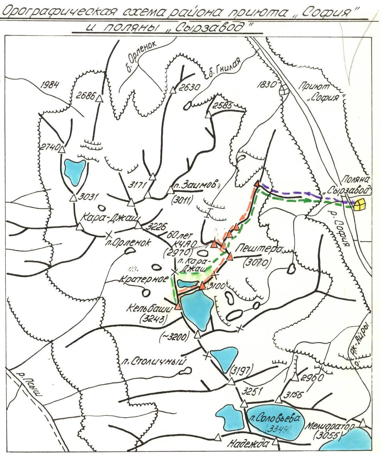
The peak 60 let KChAO (2970 m) is located in the NE spur, extending from the nodal point, in the area of the peak Kelbashi (3243 m). With its rocky bastions, it rises above the valley of the left tributary of the Sofiya River, which flows into it near the Sofiya refuge.
The peak 60 let KChAO and v. Peshtera (3070 m) are visible from the Syrzavod glade, where the base camp is located during the winter mountaineering event dedicated to the 60th anniversary of KChAO (see photographic scheme, photo 1, 2). The peaks 3100 m and Kelbashi are clearly visible from the pre-summit tower of v. 60 let KChAO.
The ascent on January 13, 1982, was preceded by a reconnaissance of the area of v. 3100 and v. Kelbashi and ascents to the first two peaks, made a few days earlier.
Nearest classified routes:
- to peak Kislovodsk (2973 m) — 1B cat. diff.,
- to peak Velinград (2936 m) — 1B, 3B, 3B cat. diff.,
- to peak Meliorator (3055 m) — 1B cat. diff.
From the Syrzavod glade with an absolute height of 1930 m, descend to the Soliya River and, in the area of the stream flowing into it from the left, cross the river in the direction of the E spur, leading to the NE ridge of peak 60 let KChAO.
Along the spur, overgrown with forest in the lower part, straight up, leaving the avalanche-prone slopes to the right and left. Having left the forest boundary, continue moving along the center of the spur to a group of separate trees and further to the last spruce, from which the rocks of the spur begin.
The mentioned spruce is visible from the Syrzavod glade.
Further along the wide rocky spur, exit to the nodal point of the end of the NE ridge, having a height of 2590 m. Here – the start of the route, 2 hours 30 minutes of ascent along a previously organized snow trail.
Route Description
Section R0–R1. Along the left part of the narrow rocky ridge (right - cornice!) with numerous gendarmes, overcome "head-on", in a rope team, with alternate and simultaneous movement with descents and ascents to the base of the wall of the first clearly defined rocky gendarme on the ridge "Tower". In the lower part of this gendarme, when moving along the ridge from the nodal point 2590 m, a reddish spot is clearly visible against the background of dark granites.
Characteristics of the section:
- Distance from R0 to R1 – 800 m
- Absolute height: 2700 m
- Average steepness: 10–15°
- Relief: consists of numerous ascents and descents along a snowy narrow ridge
- Belay: through ice axe and ledges
- Passage time: 1–1.5 hours
Section R1–R2: the gendarme "Tower" is taken "head-on" along the 4 m wall (photo 2).
Below, in a niche under the wall, on the left – a red spot. Further, there is a narrow destroyed ridge with numerous separate gendarmes of the 2nd order.
Movement:
- 110 m strictly along the ridge
- Ascent to the base of the second clearly defined gendarme "Castle" (photo 3)
- Traverse to the left 20 m along a not wide ledge
- Then ascent to the right upwards 40 m along not clearly defined ledges to the left shoulder of the "Castle" tower
- Then 20-meter traverse with a slight ascent to the col between the "Castle" and the next, and no less original in shape, but higher gendarme (2 pitons)
- Having passed the col, turn to the right
- Approximately 15 m approach to a chimney with jammed stones in it
In the upper part, the chimney slightly overhangs! A difficult 3.5-meter section along the chimney leads to a ledge, which this chimney ends with (1 piton). The ledge is in the left part of the ridge.
Further:
- Traverse with ascent 20° (50 m)
- Exit directly to the ridge, cut by a 1.5 m wide crevice
- Jump (with belay, piton) over the crevice
- Absolute height: 2830 m
- Passage time: 2 hours
Section R2–R3: Movement should be made along the left part of the initially narrow, but quickly expanding ridge with a steepness of ~50°, turning into a counterfort, which is crowned by a pre-summit tower (photo 4).
Along the way, there are a number of walls ~2 m high, in some places a partner boost is required.
After 90–100 m, the movement is obstructed by a 20 m high wall. It is taken "head-on" on the left side with piton belay (3 pitons).
The key point of the route, after overcoming which there is an exit to the counterfort.
Further movement along the inclined slabs of the counterfort, having an average steepness of 45°, to the pre-summit tower, 60 m, 2 pitons.
- Passage time: 1.5 hours
Section R3–R4: Descent 3 m from the pre-summit tower to the ridge of latitudinal direction. Turn to the right and movement along a relatively simple, destroyed, wide ridge to the summit through a small dip, 70 m, ~100 m, 0.3 hours.
The summit is a fairly flat area. It is slightly higher than the pre-summit tower.
- Ascent along the NE ridge corresponds to 1B cat. diff.
Section R4–R5: Descent from the summit along the NW ridge to the col between the peaks "60 let KChAO" and "Peshtera" takes 0.5 hours. Absolute height: 2800 m.
From the col to the left along a fairly wide NW ridge, steepness up to 45° (on average 40°), overcoming or bypassing small walls and inclined slabs, partially on snow (30 %), partially on slopes (70 %) – exit to a gentle pre-summit ridge and approximately 80–100 m – to the highest point of the peak Peshtera.
- Ascent time from the col to the summit: 1 hour
- Ascent corresponds to 1B cat. diff.
Descent from the col between the peaks Peshtera and v. 3100 was made along a rocky-scree slope, bypassing the ridge from below.
- Descent time: 0.5 hours
Section R5–R6: from the col between the peaks Peshtera and 3100 m along the NE ridge towards the visible rocky summit. Rocks of medium difficulty, passed with alternate belay.
Stages of passage:
- First 30 m: inclined slabs with steepness up to 50°
- Then: 2-meter wall – inner corner (piton)
- Further: 10-meter slab with steepness up to 55°, which rests against a vertical 2-meter wall with smooth rocks (piton)
- After the wall: there is a narrow destroyed ridge up to 40 m long, with a steepness of 40°, leading to a negative 2-meter wall, which is overcome with a boost (piton)
- A gentle destroyed ridge leads to the summit 3100 m
A cairn is being installed for the first time. It is decided to name the peak 3100 m – "Septemvri" – in honor of the Bulgarian twin city of Mineralnye Vody, and to petition for this to the Mountaineering Federation of the USSR.
- Ascent along the NE ridge corresponds to 2A cat. diff.
- Ascent time: 3 hours
Section R6–R7: descent towards v. Kelbashi initially passes along a destroyed gentle rocky ridge, then along a snowy slope, leading to the col between the peaks 3100 m and Kelbashi.
The summit Kelbashi is reached by a snowy ridge:
- Steepness: 30–40°, in the upper part up to 60°
- Length: 200–250 m
In its upper part, the snowy ridge approaches a gentle rocky ridge, partially snow-covered, up to 150 m long, which leads to the highest point 3243 m – v. Kelbashi.
- Time from v. 3100 m to v. Kelbashi: 2–2.5 hours
Descent from v. Kelbashi through the Kara-Jam pass in the direction of the col between vv. 60 let KChAO and Peshtera with exit to the NE ridge of peak 60 let KChAO in the area of the gendarme "Tower" and further along the NE ridge. Descent time 2.5–3 hours.
At the debriefing held in the presence of the release officer, head of the rescue team and participants of the event, the ascent was assessed as a combined first ascent, corresponding to 3A cat. diff. in winter conditions.
Recommendations:
- Descent is made along the NE ridge of v. 60 let KChAO.
- Bypass paths are avalanche-prone.
- The most suitable footwear is hiking boots.
- Possible overnight stays – cols between v. 60 let KChAO and v. Peshtera, as well as between v. Peshtera and Septemvri.
Leader March 1, 1982 Chuenko S.A.
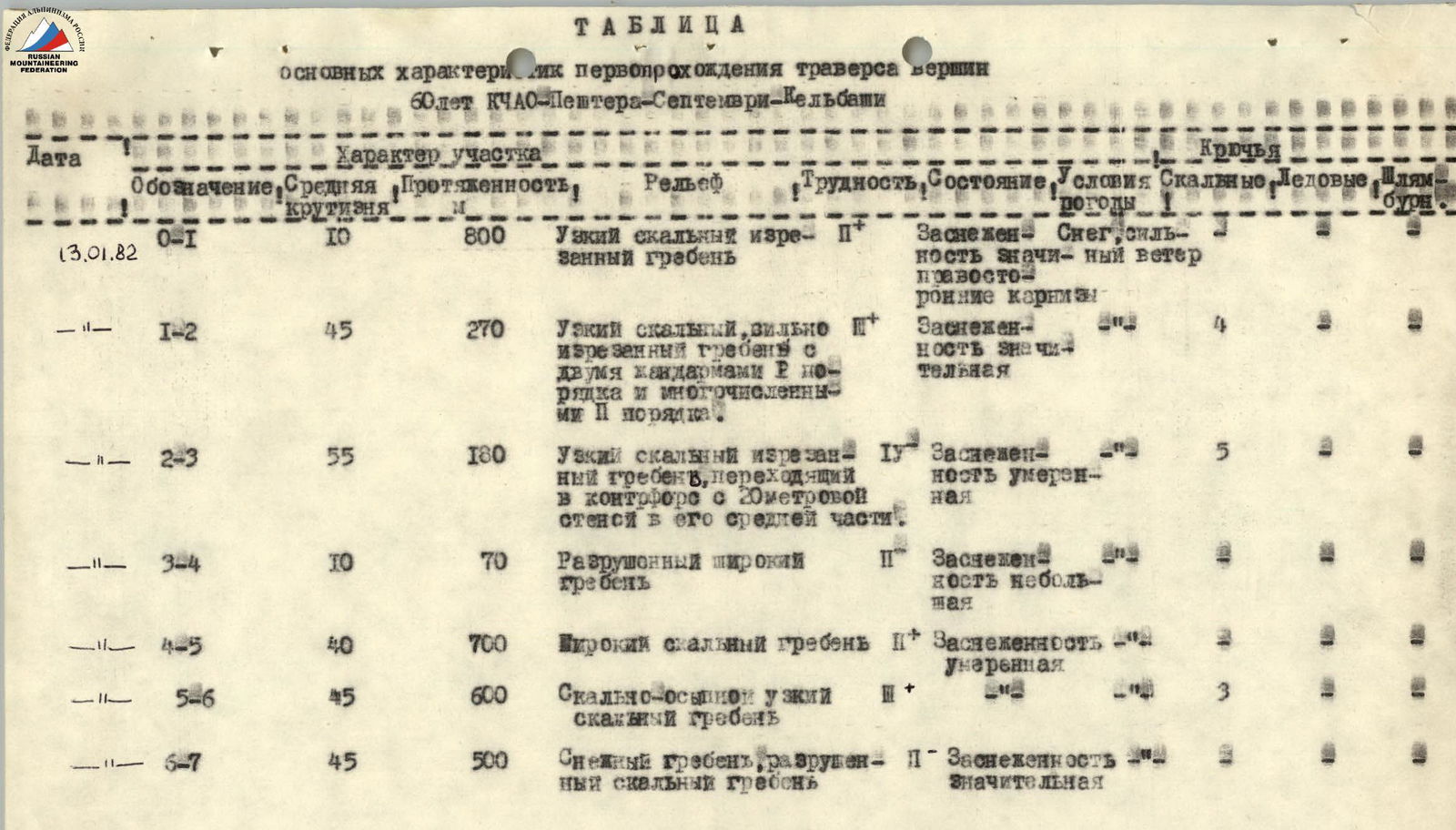
TABLE
main characteristics of the first ascent of the traverse of the peaks 60 let KChAO–Peshtera–Septemvri–Kelbashi
| Date | Designation | Average steepness | Length | Relief | Difficulty | Weather conditions | Conditions | Rock pitons | Ice pitons | Bolt pitons |
|---|---|---|---|---|---|---|---|---|---|---|
| 13.01.1982 | R0–R1 | 10° | 800 m | Narrow rocky jagged ridge | II+ | Snow cover, right-side cornices | Snow, strong wind | |||
| — | R1–R2 | 45° | 270 m | Narrow rocky, heavily jagged ridge with two gendarmes of the II order and numerous II order | II+ | Significant snow cover | 4 | |||
| — | R2–R3 | 55° | 180 m | Narrow rocky jagged ridge, turning into a counterfort with a 20-meter wall in its middle part | IV | Moderate snow cover | 5 | |||
| — | R3–R4 | 10° | 70 m | Destroyed wide ridge | II+ | Little snow cover | ||||
| — | R4–R5 | 40° | 700 m | Wide rocky ridge | II+ | Moderate snow cover | ||||
| — | R5–R6 | 45° | 600 m | Rocky-scree narrow rocky ridge | II+ | 3 | ||||
| — | R6–R7 | 45° | 500 m | Snowy ridge, destroyed rocky ridge | II+ | Significant snow cover |
Comments
Sign in to leave a comment