
| CLIMBING CLASS | — rock climbing |
|---|---|
| CLIMBING AREA | — Western Caucasus, Arkhyz, northern spur of the Sofiyskiy ridge between the Psyish and Sofiya river valleys |
| PEAK, ROUTE | 2970 m |
| — «60 лет КЧАО» (proposed by first ascensionists) along the North-Eastern ridge | |
| EXPECTED DIFFICULTY CATEGORY — 2B (winter) | |
| ROUTE CHARACTERISTICS | — rock, ridge, absolute height difference 380 m |
| NUMBER OF PITONS DRIVEN | — 9 |
| NUMBER OF CLIMBING HOURS | — 6 hours (from the start of the route to the summit) |
| NUMBER OF NIGHTS | — not required on the route |
| CLIMBING LEADER | — Chuenko S.A. — Candidate Master of Sports |
| PARTICIPANTS | — Tretyakov V.Ya. — 1st category |
| Belokurov I.L. — 1st category | |
| Gavrilov I.V. — 1st category | |
| Oleinikov N.P. — Candidate Master of Sports | |
| Zaporozhchenko E.V. — Candidate Master of Sports | |
| TEAM COACH — Master of Sports of the USSR Popov V.P. | |
| DATE OF DEPARTURE AND RETURN | — January 8, 1982 |
Legend
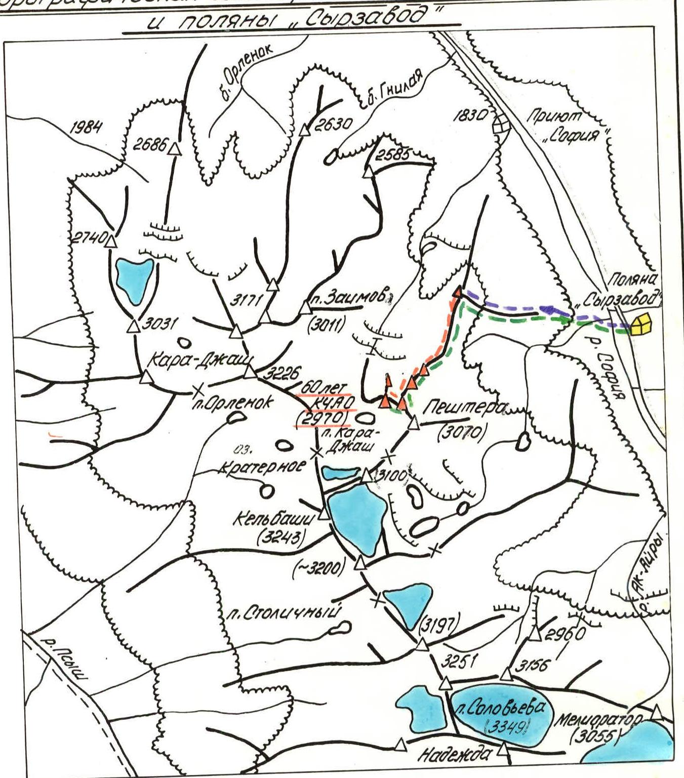
□ — Base camp —— Path to the start of the route —— Ascent route —— Descent path to the base camp —∆— Ridges and peaks Mелиоратор (3055) First ascents 1980–1982. Glaciers
The unnamed peak 2970 m is located in the north-eastern spur extending from the nodal point near the peak Кельбаши (3243 m). It rises above the valley of the left tributary of the Sofiya River with rocky bastions, where the latter flows into the Sofiya River near the «София» shelter.
To the south-east of peak 2970 m lies another unnamed peak — 3070 m, visible from the «Сырзавод» clearing, where the base camp was located during the winter mountaineering event dedicated to the 60th anniversary of the КЧАО (see orographic scheme, photo I).
Peak 2970 m was chosen as the object of the jubilee first ascent during reconnaissance trips to the area in November and December 1981 by the reconnaissance group and was finally approved by the coaches' council of the federation on December 20, 1981.
The North-Eastern ridge, descending from the forepeak of peak 2970 m, was considered the most suitable route in terms of avalanche safety for the approach and the climb itself (consultation with candidate of geographical sciences, avalanche specialist at the Vysokogorny Geophysical Institute in Nalchik, Mr. Runich A.V.).
Nearby classified routes:
- on peak Кисловодск (2973 m) — 1B category
- on peak Велинград (2936 m) — 1B, 3B, 3B category
- on peak Мелиоратор (3055 m) — 1B category
The ascent on January 8, 1982, was preceded by a reconnaissance of the eastern spur and the initial part of the North-Eastern ridge conducted by the rescue team of the event.
From the «Сырзавод» clearing with an absolute elevation of 1930 m, descend to the Sofiya River and, near the mouth of its left tributary, cross the river in the direction of the eastern spur, which leads to the North-Eastern ridge of peak 2970 m.
Follow the spur, which is forested in its lower part, straight up, leaving avalanche-prone slopes to the right and left. After exiting the forest, continue moving along the center of the spur towards a group of isolated trees and then to the last spruce, from which the rocky part of the spur begins. This spruce is visible from the «Сырзавод» clearing.
Further, along the broad rocky spur, reach the nodal point at the end of the North-Eastern ridge with an elevation of 2590 m. This marks the beginning of the route.
3 hours of ascent along a snow trail organized in advance.
Route Description
Section R0–R1
Along the left part of the narrow rocky ridge (be cautious of cornices on the right!) with numerous pinnacles overcome "head-on," in rope teams — alternating and simultaneous movement with descents and ascents — to the base of the first pronounced rocky pinnacle on the ridge — «Башня» (Tower).
In the lower part of this pinnacle, when moving along the ridge from the nodal point 2590, a reddish spot is visible against the dark granites.
Distance from R0 to R1 — 800 m.
Absolute elevation — 2700 m, average slope — 10–15°, however, it consists of numerous ascents and descents along the snowy narrow ridge.
Protection — through ice axe and rock outcrops.
Time taken — 1.5–2 hours.
Section R1–R2
- The pinnacle «Башня» is taken "head-on" up a 4 m wall (photo 2). At the bottom, in a niche under the wall, to the left — a piton!
- Further, a narrow, destroyed ridge follows with numerous individual pinnacles of the 2nd order.
- After 110 m of movement strictly along the ridge — a 10 m deep gap and ascent to the base of the second pronounced pinnacle — «Замок» (Lock) (photo 3).
- Traverse left 20 m along a not very wide ledge, then ascend right — up 40 m along faintly marked ledges to the left shoulder of the «Замок» tower.
- Then, a 20-meter traverse with a slight ascent to the col between «Замок» and the next, less original in shape but higher pinnacle (2 pitons).
- After passing the col, turn right and after about 15 m — approach a chimney with wedged stones. In its upper part, the chimney slightly overhangs.
- A difficult 3.5-meter section through the chimney leads to a ledge where the chimney ends (1 piton). The ledge is on the left part of the ridge.
- Traverse with ascent at 20° (50 m) ends with an exit directly onto the ridge, cut by a 1.5-meter wide crevice.
- Jump (with protection, piton) over the crevice.
Absolute elevation — 2830 m.
Time taken — 2 hours of climbing.
Section R2–R3: Movement should be carried out along the left part of the initially narrow but quickly broadening ridge with a slope of ~50°, transitioning into a counterfort that culminates in a forepeak tower (photo 4).
Along the way, several 2-meter high walls are encountered, requiring partner assistance in some places. After 90–100 m, movement is blocked by a 20-meter high wall.
Overcoming the wall:
- Is done head-on on the left side;
- Requires piton protection (3 pitons);
- Key point of the route, after overcoming which — exit onto the counterfort.
Further movement along the inclined slabs of the counterfort with an average slope of 45°:
- To the forepeak tower, 60 m, 2 pitons;
- Category of difficulty: 5;
- Time taken: 2 hours of climbing.
Section R3–R4: Descend 3 m from the forepeak tower onto a ridge of latitudinal orientation. Turn right and follow a relatively easy, destroyed, broad ridge to the summit through a small gap, 70 m, ~10°, 0.3 hours of climbing.
The summit — a fairly level area. It is slightly higher than the forepeak tower. A cairn is built for the first time. A decision is made to name peak 2970 m — peak «60-летия КЧАО» and to petition for the approval of the route along the North-Eastern ridge to peak «60 лет КЧАО» before the USSR Mountaineering Federation. Descent along the ascent route is the safest, although it requires 3–4 hours of fairly technical work:
- 20 m rappel when descending from the counterfort,
- several short sport descents,
- the last of which — from the pinnacle «Башня». Time for the route from Base camp to Base camp — 11–13 hours (the group spent 12 hours on the route).
At the debriefing conducted in the presence of the event organizers, the head of the rescue team, and the participants, the ascent was evaluated as a ROCK WINTER FIRST ASCENT, corresponding to the 2B category.
Recommendations:
- Ascent and descent are carried out along the North-Eastern ridge.
- Detour paths — avalanche-prone!
TABLE of main characteristics of the first ascent route to peak «60 лет КЧАО»
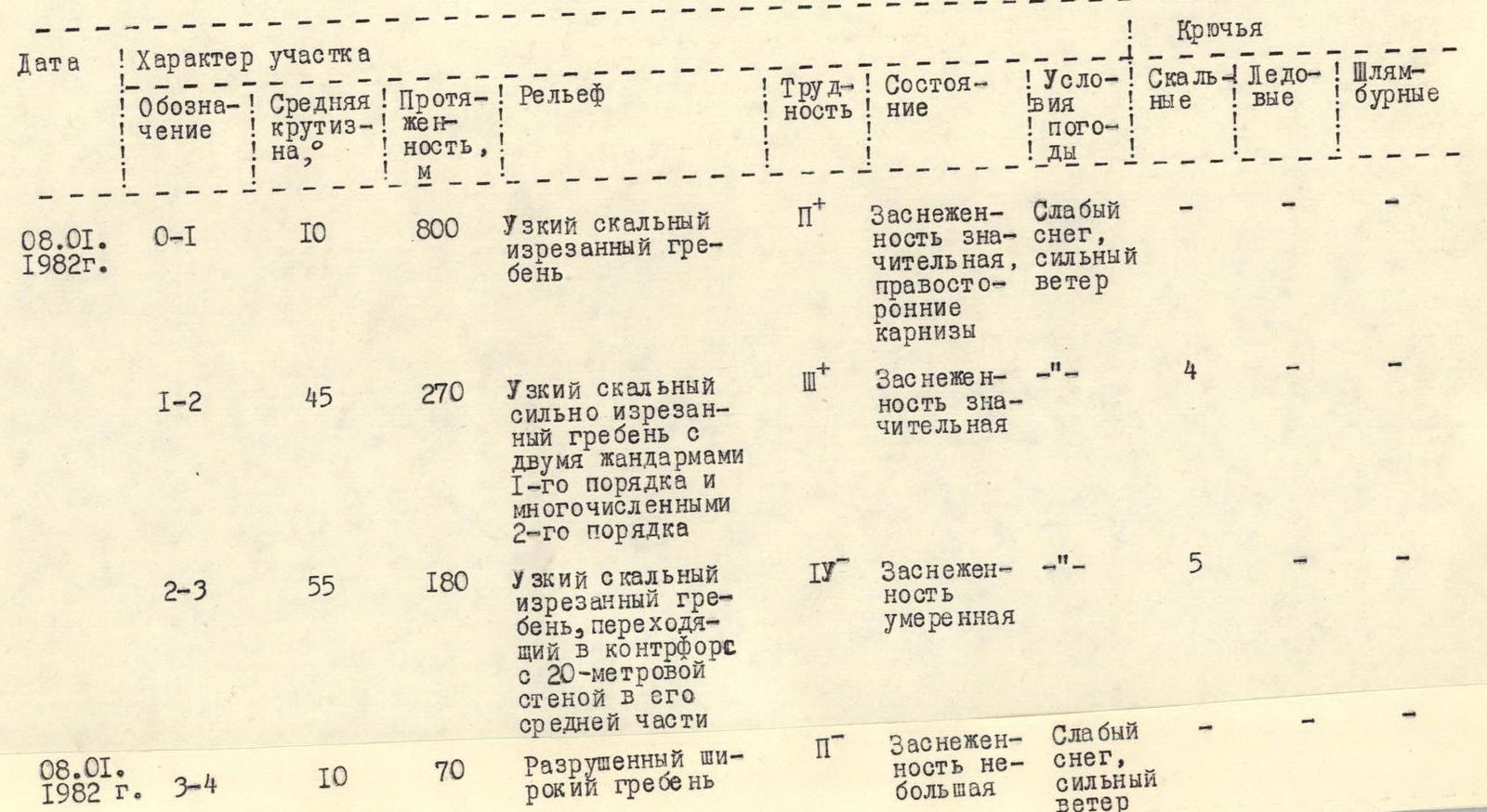
| Date | Designation | Average slope, ° | Distance, m | Relief | Difficulty | Condition | Weather conditions | Rock | Ice | Bolted |
|---|---|---|---|---|---|---|---|---|---|---|
| 08.01.1982 г. | R0–R1 | 10 | 800 | Narrow rocky jagged ridge | 2 | Significant snow cover, right-side cornices | Light snow, strong wind | – | – | – |
| R1–R2 | 45 | 270 | Narrow rocky, heavily jagged ridge with two 1st order pinnacles and numerous 2nd order | 3 | Significant snow cover | – | 4 | – | – | |
| R2–R3 | 55 | 180 | Narrow rocky jagged ridge transitioning into a counterfort with a 20-meter wall in its middle | 4 | Moderate snow cover | – | 5 | – | – | |
| 08.01.1982 г. | R3–R4 | 10 | 70 | Destroyed broad ridge | 2 | Little snow cover | Light snow, strong wind | – | – | – |
Comments
Sign in to leave a comment