Peak 2970.0 (Zaimov-peak) Route: via the southwestern ridge Complexity category — 1B cat. (combined) Leader: G. G. Skosyrev Western Caucasus, Arkhyz, Gnilaya gully, Kara-Jash mountain range Section in CMGA — 2.1.
E-mail — ZHUR58@RAMBLER.RU
Report
On the first ascent of the climbing route to the summit of Peak 2970.0 (Zaimov-peak) "Via the southwestern ridge" 1B cat. (combined).
At the year-round alpine event: "Championship and primacy of NP 'Club of Northern Travels 'Sauk-Pai' 2012 (class 'First ascents')".
Region: Karachay-Cherkess Republic Mountain country: Western Caucasus Gorge: Gnilaya gully Ridge: Kara-Jash mountain range Summit: Peak 2970.0 (Zaimov-peak) Route: via the southwestern ridge Complexity category — 1B cat. (combined)
Prepared by: G. Skosyrev, S. Zhuravlev
May, 2012 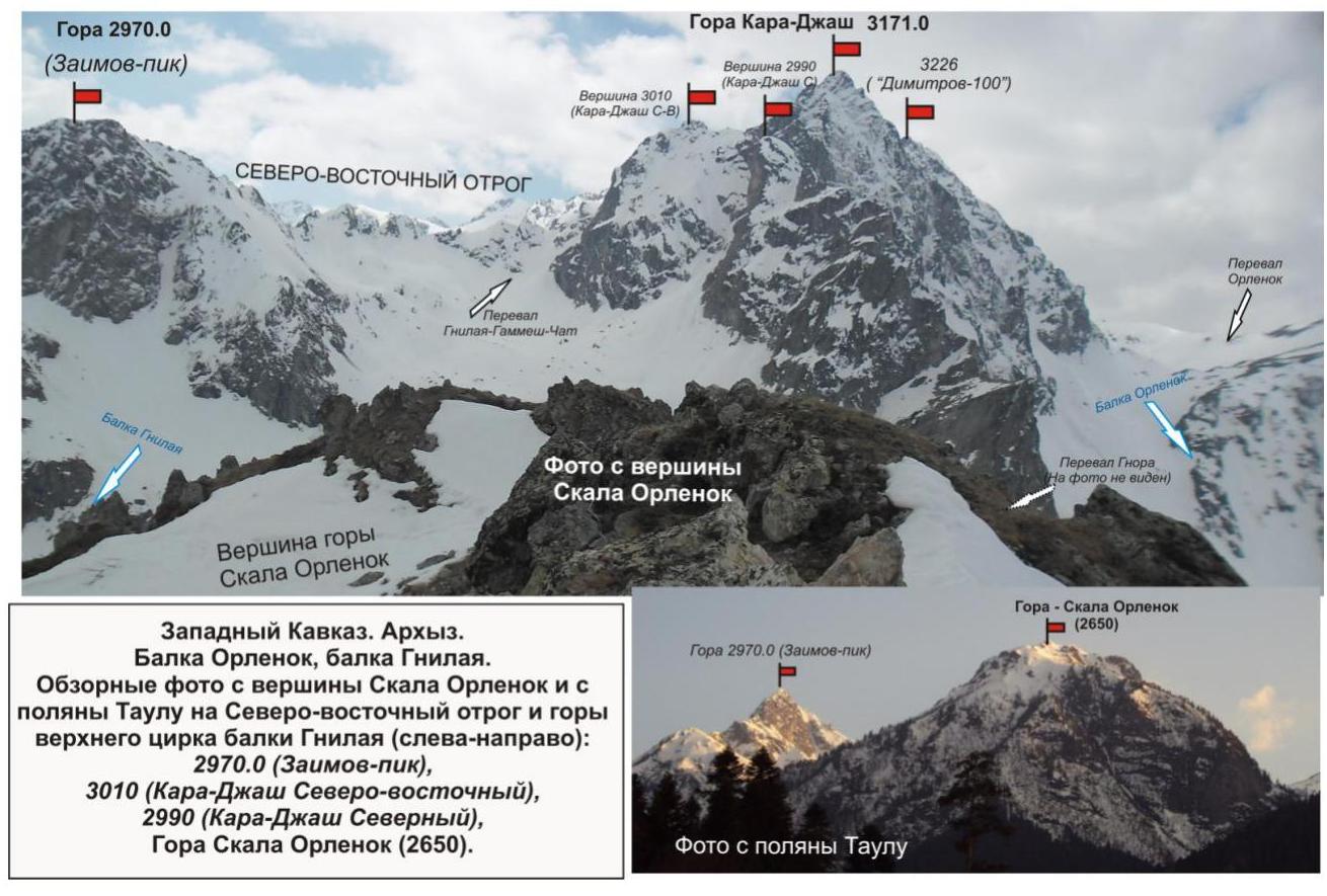
Description of the summit
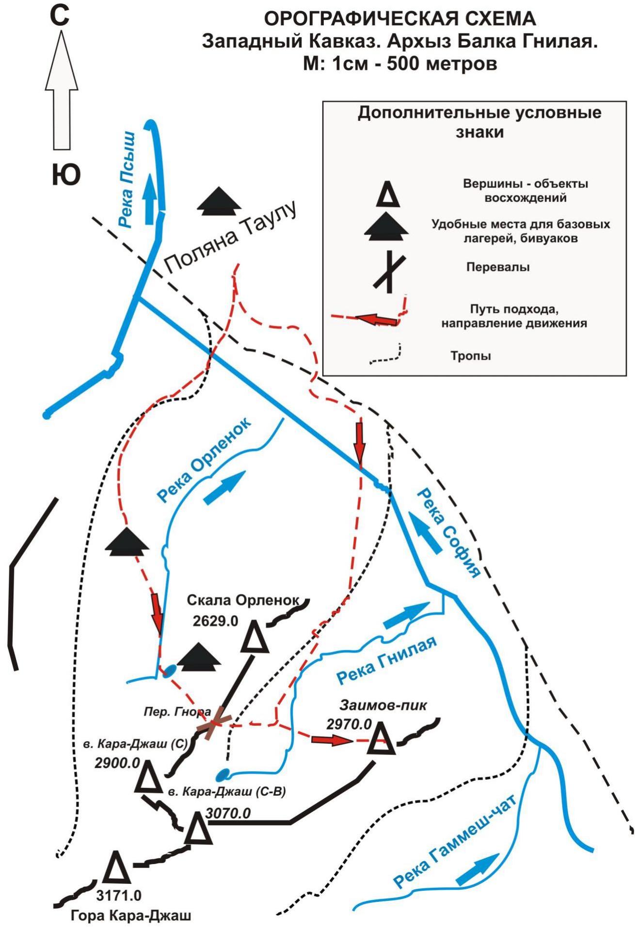
Peak 2970.0 (Zaimov-peak) — a summit that completes the northwestern spur of the Kara-Jash mountain range. Located on the territory of the Caucasus Federal District of the Russian Federation, in the Karachay-Cherkess Republic, Arkhyz mountain region, between the Gammesh-Chat and Gnilaya rivers.
Peak 2970.0 (Zaimov-peak) — a pronounced mountain, easily identifiable from the Taulu meadow. Officially, the summit has no name, so it has a conditional tourist-climbing name — Zaimov-peak, given in honor of the Bulgarian general, known for the liberation of Bulgaria from the Turkish yoke. The name allows the summit to be identified.
There was previously one route to Peak 2970.0 (Zaimov-peak) via the northeastern ridge — 2B (c) cat.
Description of the route
The route "Via the southwestern ridge" — a characteristic training combined route 1B cat., with a full set of natural obstacles corresponding to routes of this level.
Equipment
To complete the ascent as part of a sports group of 4 people, the following special equipment is required on the route: personal — standard, crampons and ice axe; public: main rope 10 mm — 2 × 50 m, hammer sk. — 2 pcs., hooks sk. — 4 pcs., ice axe — 1 pc., закладные elements — 6 pcs. Ice screws — 2 pcs. Quickdraws — 6 pcs. Loops — 6 pcs.
Approaches
The ascent is made either from the bivouac on the Taulu meadow or from the bivouac in the upper cirque of the Orlenok gully.
Approach from the base camp on the Taulu meadow. Go upstream along the Sofia River along a dirt road to the confluence of the left-bank tributary of the Gnilaya River into the Sofia. Cross the Sofia River over a log. Then from the meadow with a precipitation gauge, ascend along the trail along the Gnilaya River to the lake in the upper cirque of the Gnilaya gully.
Approach from the base camp in the Orlenok gully. Along a weakly expressed trail, ascend to the Gnora pass between the peaks Skala Orlenok and Kara-Jash (C) and descend to the lake in the upper cirque of the Gnilaya gully. The route begins from the lake.
Technical part
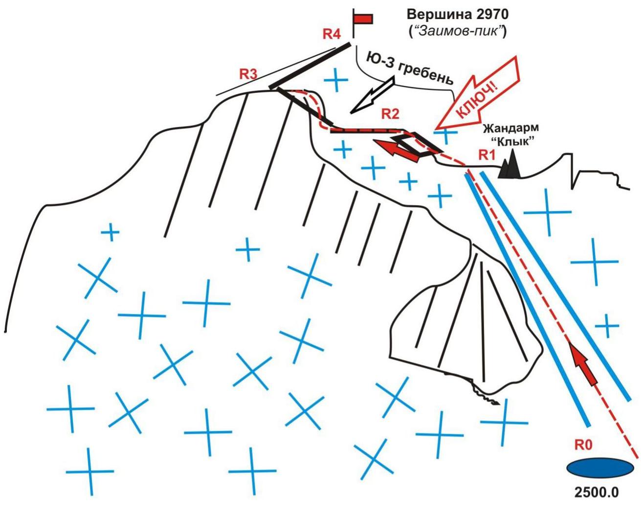
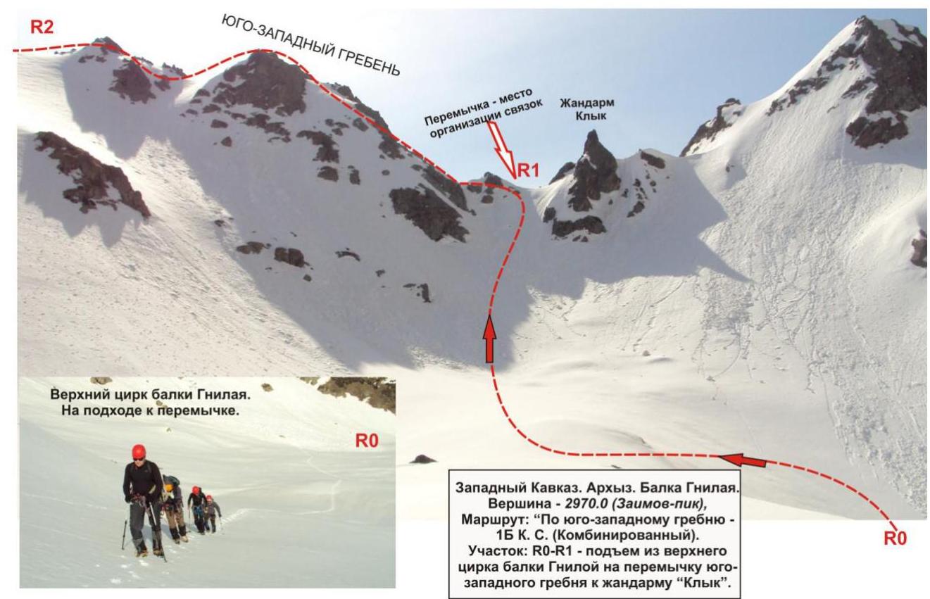
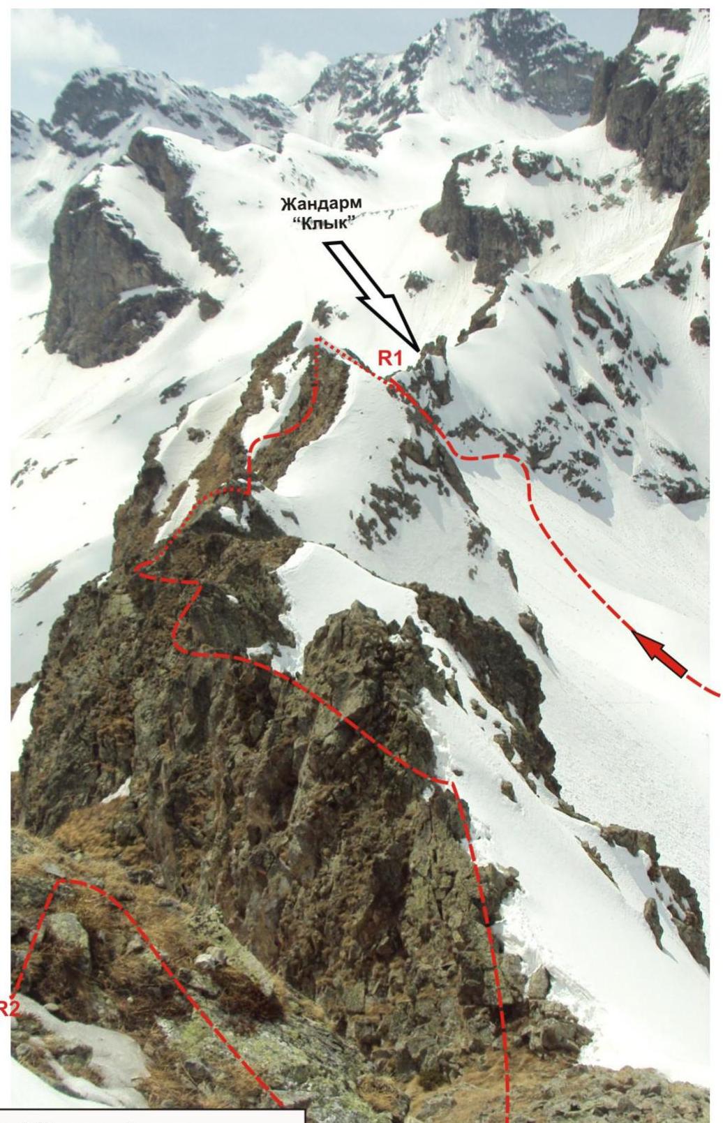
From the lake, ascend first along a snowy (in summer, scree) slope to the base of the couloir leading to the northeastern spur. To the left of the summit, ascend to the base of the southwestern ridge of Peak 2970.0 (Zaimov-peak). There is a good landmark — the "Klyk" gendarme. On the saddle under the "Klyk" gendarme, it is convenient to organize rope teams.
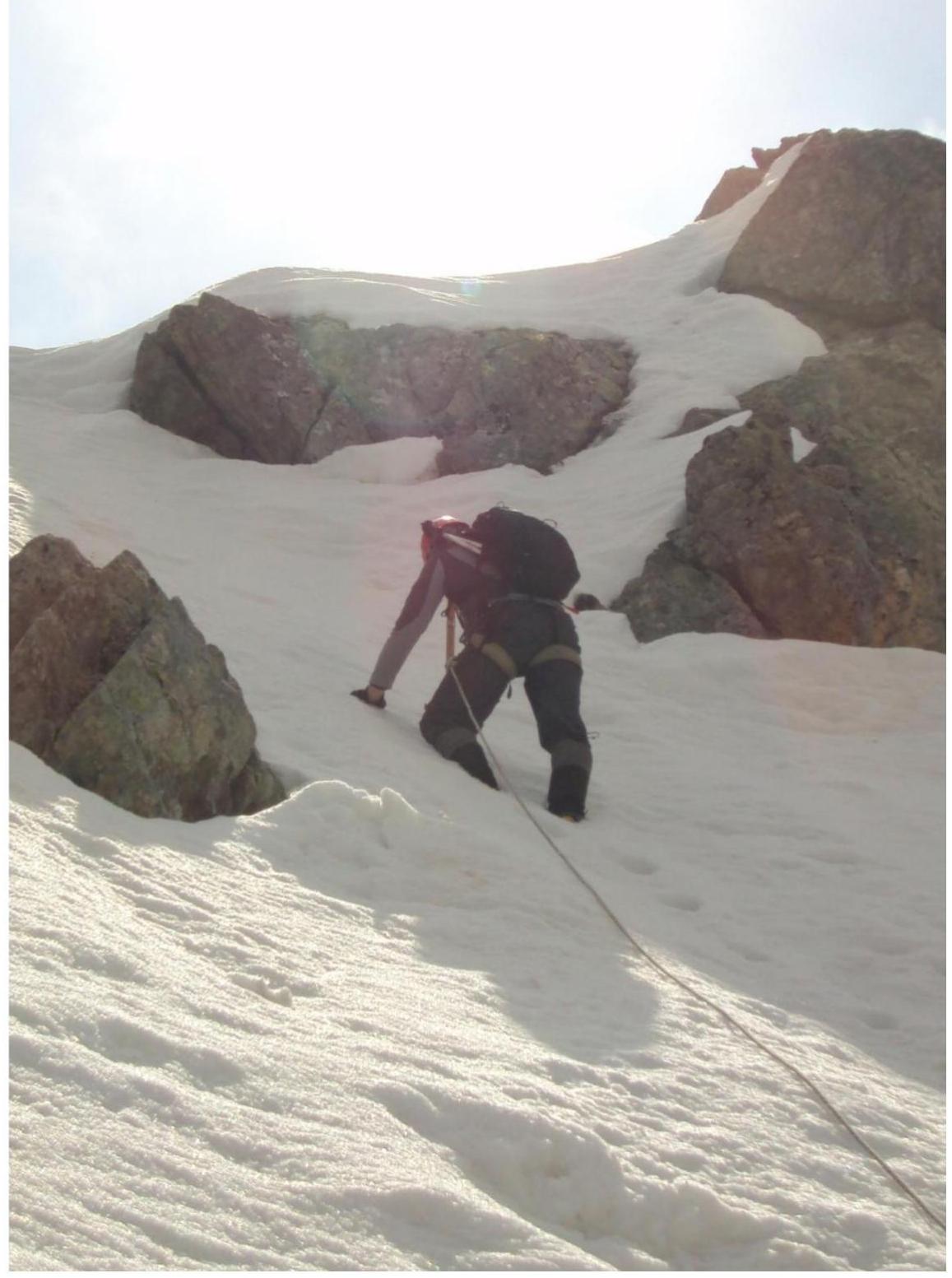
The key to the route — the ascent along the southwestern ridge from the "Klyk" gendarme. Inclined slabs. For the organization of intermediate belay points, there are convenient ledges for loops, cracks for закладные elements. The length of the key section is 2–2.5 ropes.
After passing the key section, the path to the summit lies along the destroyed rocky ridge, then along a snowy-scree (in summer, grassy) slope.
The summit is pronounced. The cairn is easily found. A note from a sports group from Nevinnomyssk was taken.
Descent from the summit
The descent from the summit is carried out along a snowy slope leading to the Gnilaya gully.
Kara-Jash Mountain
Passport
- Section number according to CMGA — 2010 — 2.1. Western Caucasus, mountain region — Arkhyz, Kara-Jash ridge
- Name of the summit: 2970.0 (Zaimov-peak) height: 2970.0 m. Route: via the southwestern ridge
- Cat. sl.: 1B
- Character of the route — combined.
- Height difference of the route: 470 m
- Length of the route: 1050 m
- Length of sections of the highest cat. sl.: 1 — 2 sections — 650 m, 2 — 3 sections — 400 m, 3 — 0 sections — 0 m, 4 — 0 sections — 0 m, 5 — 0 sections — 0 m, 6 — 0 sections — 0 m.
- Average steepness: main part of the route — 35°, entire route — 30°.
- Hooks used: Total used on the route: rock hooks — 0, закладок — 4, bolted stationary — 0, ITO — 0, bolted removable — 0. Left "hooks" on the route: total — 0, including bolted — 0.
- Exit to the route — 6:00, May 29, 2012 Exit to the summit — 12:00, May 29, 2012 Return to BL — 15:00, May 29, 2012
- Team's working hours: — 11 hours.
- Leader: Gennadiy Skosyrev (CMS, instructor-methodologist 2nd category, Veliky Novgorod).
Participants:
- A. Erygin (3rd sports category, Voronezh)
- N. Sysoev (3rd sports category, Voronezh)
- A. Sotnikov (3rd sports category, Voronezh)
- T. Knyazeva (3rd sports category, Voronezh)
- Coach: Zhuravlev Sergey Vasilyevich, title — CMS, instructor-methodologist 1st category.
Western Caucasus. Arkhyz. Gnilaya gully. Summit — 2970 m (Zaimov-peak). Route: "Via the southwestern ridge" 1B cat. (combined). Scheme in UIAA symbols.
Technical description of the route
Approach: 1st option (from Taulu meadow): along a dirt road along the Sofia River to the confluence of the left-bank tributary — Gnilaya River into Sofia. Then cross the Sofia River over a log and ascend along the Gnilaya River valley along the trail to the upper cirque to the lake. 2nd option (from Orlenok gully): from the base camp along a weakly expressed trail, ascend to the Gnora pass (at tourists 1B cat.). Then descend along a snowy (in summer, scree, overgrown with rhododendron) slope to the lake in the upper cirque of the Gnilaya gully.
R0 — lake in the upper cirque of the Gnilaya gully. R0–R1 — ascent to the saddle of the northeastern spur to the "Klyk" gendarme under the base of the southwestern ridge of the summit. Snowy slope. Length 800 m. Steepness — from 15 to 35°. Level of complexity — 1–2 (in the upper part 100 m — 2). Movement is simultaneous, self-insurance with an ice axe.
R1–R2 — ascent along the southwestern ridge. Rocky slabs — key to the route. Length 100 m. Steepness 25–30°. Level of complexity — 2. Movement:
- simultaneous on a shortened rope;
- in some areas — alternate;
- mutual belay by laying a rope around the ridge ledges;
- use of закладные.
R2–R3 — passage along the southwestern ridge. Destroyed rocks. Length — 100 m. Steepness — 25°. Level of complexity — 2. Simultaneous movement on a shortened rope, mutual belay.
R3–R4 — ascent to the summit dome. Scree, snowy slope. Length — 50 m. Steepness — 15–20°. Level of complexity — 1. Simultaneous movement in rope teams.
R4 — summit. Pronounced. The cairn is easily found.
Descent:
- Along the slope towards the Gnilaya gully.
Western Caucasus, Arkhyz, Orlenok gully
Peak 2970.0 (Zaimov-peak)
Route: "Via the southwestern ridge" 1B (combined) (approximately)
Table of natural obstacles on the route:
| Section | Length | Steepness | Character of relief | Cat. sl. | Number of hooks/закл |
|---|---|---|---|---|---|
| R0 — watershed lake in the upper cirque of the Gnilaya gully | |||||
| R0–R1 — Ascent along the slope and couloir to the saddle in the northeastern spur to the "Klyk" gendarme | 800 | 15–25 | Snowy slope | 1 (in the upper part 100 m — 2) | 0 / 0 |
| R1–R2 — Ascent to the southwestern ridge along the slabs | 100 | 35 | Rocky slabs | 2 | 0 / 4 |
| R2–R3 — Passage along the ridge | 100 | 25–30 | Slabs | 2 | 0 / 0 |
| R3–R4 — exit to the summit dome | 50 | 15–20 | Snowy (scree slope) | 1 | 0 / 0 |
| R4 — summit 2970.0 (Zaimov-peak) | |||||
| Descent along the snowy slope to the Gnilaya gully | 35 | Snowy slope | 2, 1 |
Total
Length of the route — 1050 m, average steepness — 30°, character of relief — combined.
Sections:
- 1 — 2 sections
- 2 — 3 sections
Used hooks and закладные: 0/4. Left hooks and закладные: 0/0.
Base camp Taulu meadow, Western Caucasus. Arkhyz. Orlenok gully. Summit — 2970.0 (Zaimov-peak). Route: "Via the southwestern ridge" 1B cat. (combined).

Technical description of the route
Approach: 1st option (from Taulu meadow): along a dirt road along the Sofia River to the confluence of the left-bank tributary — Gnilaya River into Sofia. Then cross the Sofia River over a log and ascend along the Gnilaya River valley along the trail to the upper cirque to the lake. 2nd option (from Orlenok gully): from the base camp along a weakly expressed trail, ascend to the Gnora pass (at tourists 1B cat.). Then descend along a snowy (in summer, scree, overgrown with rhododendron) slope to the lake in the upper cirque of the Gnilaya gully.
R0 — lake in the upper cirque of the Gnilaya gully. R0–R1 — ascent to the saddle of the northeastern spur to the "Klyk" gendarme under the base of the southwestern ridge of the summit. Snowy slope. Length 800 m. Steepness — from 15 to 35°. Level of complexity — 1–2 (in the upper part) cat. sl. Movement is simultaneous, self-insurance with an ice axe.
R1–R2 — ascent along the southwestern ridge. Passage of the key section. Rocks. Complicated inclined slabs. Length 100 m. Steepness 25–30°. Level of complexity — 2. Movement is simultaneous on a shortened rope, mutual belay by laying a rope around N, E ledges and using loops on ledges and закладные.
R2–R3 — passage along the southwestern ridge. Simple destroyed rocks. Length — 100 m. Steepness — 25–30°. Level of complexity — 2. Movement is simultaneous on a shortened rope, mutual belay.
R3–R4 — exit to the summit dome. Simple snowy-scree slope. Length — 50 m. Steepness 15–20°. Cat. sl. — 1. Simultaneous movement in rope teams.
R4 — summit. Pronounced. The cairn is easily found.
Descent:
- Along the snowy slope towards the Gnilaya gully.
Western Caucasus. Arkhyz. Gnilaya gully. Summit — 2970.0 (Zaimov-peak).
Route: "Via the southwestern ridge" 1B cat. (combined).
Section: R0–R1 — ascent from the upper cirque of the Gnilaya gully to the saddle of the southwestern ridge to the "Klyk" gendarme.
Photo characterizing the features and steepness of the slope.
Western Caucasus. Arkhyz. Gnilaya gully. Summit — 2970 m (Zaimov-peak). Route: "Via the southwestern ridge" 1B cat. (combined).
Section R1–R2:
- Ascent along the rocky ridge from the "Klyk" gendarme.
Photo (top) characterizing the features of the rocks and steepness of the ridge. 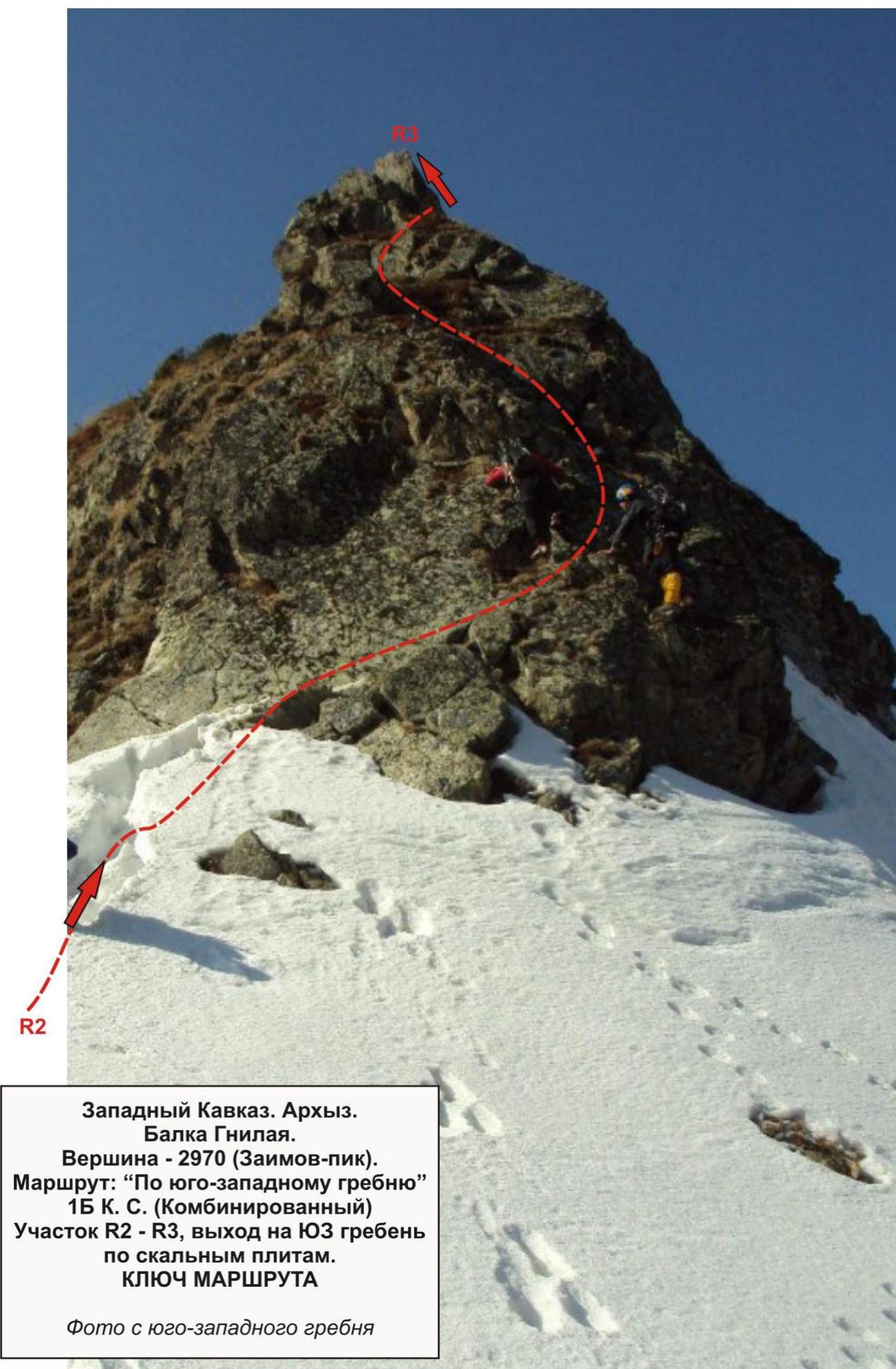
Western Caucasus. Arkhyz. Gnilaya gully. Summit — 2970 m (Zaimov-peak). Route: "Via the southwestern ridge" 1B cat. (combined). Section R2–R3, exit to the SW ridge along rocky slabs.
Key to the route
Photo from the southwestern ridge. 
Western Caucasus. Arkhyz. Gnilaya gully. Summit — 2970 (Zaimov-peak). Route: "Via the southwestern ridge" 1B cat. (combined). Section R3.
Summit:
- Zaimov-peak (2970 m).
Route:
- Via the southwestern ridge, 1B cat. (combined).
Section: R3.
Photo taken in May 2012.