ASCENT DOCUMENT
- Ascent type: rock climbing
- Ascent area: Caucasus, Krasnodar Krai up to Marukh pass
- Ascent route: traverse of Tsyndyshko: Northern 3102 m, 2nd Northern 3107 m, Main 3210 m, South-Western 3150 m.
- Proposed difficulty category: 4A
- Pitons driven: rock: 32 (including chocks) ice: 4 bolt: –
- Total climbing hours: 23
- Number of bivouacs and their characteristics: 1 bivouac, good
- Group composition:
- Boyko Viktor Viktorovich: 1st sports category, leader
- Velmiseev Pavel Aleksandrovich: 1st sports category
- Semenov Mikhail Ivanovich: 1st sports category
- Nedelkin Vladimir Ilich: 1st sports category
- Noskov Aleksey Mikhailovich: 1st sports category
- Kuznetsov Yuri Nikolayevich: 1st sports category
- Bobrov Aleksandr Mikhailovich: 1st sports category
- Bichukov Viktor Vladimirovich: 1st sports category
- Coach: CMS Gorbachevsky Aleksandr Dmitriyevich
- Start of ascent: April 28, 1980
- Return: April 29, 1980
Brief description of the approach to the route
From the base camp along the shore of Lake Kardyvach, bypassing it to the right, up the Upper Mzymta River to the slope of Tsyndyshko North peak. Then straight up to the rocky ridge, flanked by two narrow couloirs. From the base camp - 2–2.5 hours.
Brief explanation for the table
R0–R1: A moderately difficult section to the rocky counterfort - 6 ropes (pitons) to the control cairn and its end.
R1–R2: Down to the left to a saddle (30 m), then up through rocky outcrops towards the second counterfort from the left.
R2–R3: On the left side of the counterfort.
R7–R8: From the saddle to the rocks on the ridge. Then along the snowy and rocky ridge or traverse up to the right under a large rocky outcrop and, leaving it to the left, up through snow and rocks onto the ridge.
R8–R9: Down through a rocky ridge via rocks and traverse under the wall 15 m (70–75°), then up a rocky ridge to under the overhanging rocks. The overhang is bypassed on the right via a steep (80°) wall (30 m) with an exit onto a rocky and snowy ridge. Then along a steep ridge (140 m) to a snowy summit. Bivouac. 2–4 hours.
R9–R10: Traverse to the right through rocks of moderate difficulty, exit onto a snowy-rocky ridge and then to a wall (100 m). Up a 15 m wall (80°). Then to the summit.
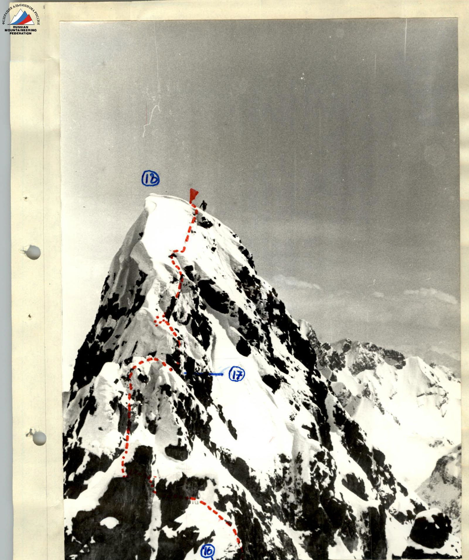
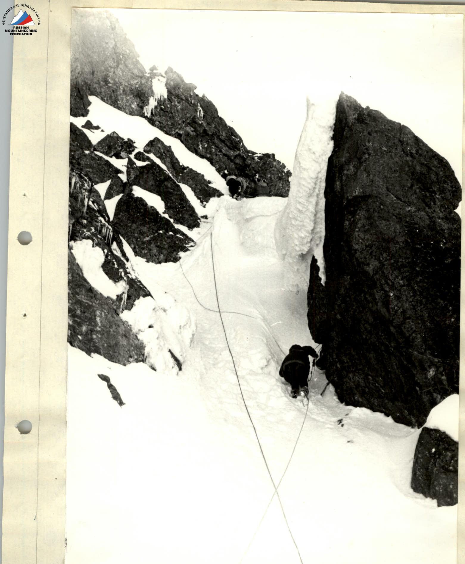
R12–R13: Up to the right through steep (50°) snow towards a steep internal angle leading to Tsyndyshko Main peak.
R13–R14: Up steep (70°) smooth slabs of the internal angle to the summit.
R15–R16: 40 m rappel, 40 m sport descent and exit via a couloir to the saddle between Tsyndyshko Main and Tsyndyshko South-Western peaks.
R16–R17: From the saddle up a steep (50°) snow slope, one and a half ropes to the right, to the shoulder of a ridge. Up a rocky wall (8 m, difficult climbing) to the next wall (climbing of moderate difficulty, 10 m) and exit onto a pinnacle (1 rope).
R17–R18: Down through difficult snowy rocks to a narrow saddle 10 m and along it 5 m (cornice). From the saddle, bypassing overhanging rocks on the right, up to the ridge (15 m - difficult climbing). Along the ridge via a rocky wall (10 m). Then steep snow and snowy rocks - exit to Tsyndyshko South-Western peak, one and a half ropes.
Descent via a category 2A route towards Tsyndyshko pass.
Table of main characteristics of the ascent route
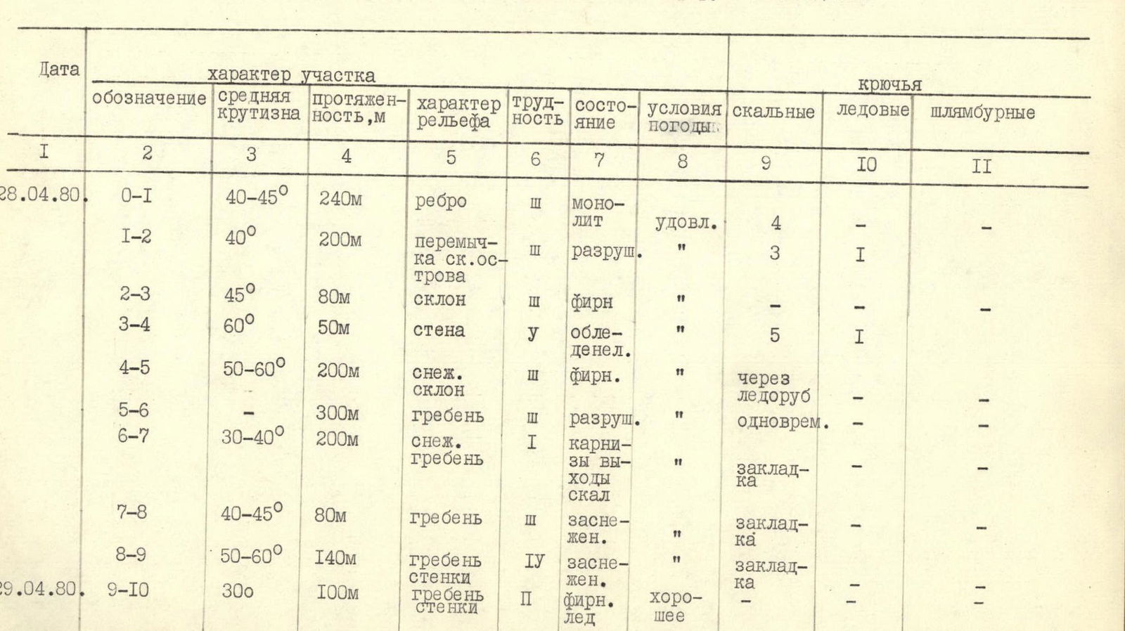
| Date | Designation | Average steepness | Length, m | Terrain characteristics | Difficulty | Condition | Weather conditions | Rock pitons | Ice pitons | Bolt pitons |
|---|---|---|---|---|---|---|---|---|---|---|
| 28.04.1980 | R0–R1 | 40–45° | 240 m | ridge | 3 | monolithic | satisfactory | 4 | – | – |
| R1–R2 | 40° | 200 m | saddle, rocky outcrops | 3 | crumbling | " | 3 | 1 | – | |
| R2–R3 | 45° | 80 m | slope | 3 | firn | " | – | – | – | |
| R3–R4 | 60° | 50 m | wall | 5 | iced | " | 5 | 1 | – | |
| R4–R5 | 50–60° | 200 m | snowy slope | 3 | firn | " | via ice axe | – | – | |
| R5–R6 | – | 300 m | ridge | 3 | crumbling | " | simultaneous | – | – | |
| R6–R7 | 30–40° | 200 m | snowy ridge | 1 | cornices, rocky outcrops | " | chock | – | – | |
| R7–R8 | 40–45° | 80 m | ridge | 3 | snowy | " | chock | – | – | |
| R8–R9 | 50–60° | 140 m | ridge, walls | 4 | snowy | " | chock | – | – | |
| 29.04.1980 | R9–R10 | 30° | 100 m | ridge, walls | 2 | firn, ice | good | – | – | – |
| R10–R11 | 40–45° | 100 m | slabs, ridge | 3 | fresh snow | – | – | – | – | |
| R11–R12 | 50–60° | 120 m | slope, rocky outcrops | 4 | snow | – | chock | – | – | |
| R12–R13 | 50° | 160 m | slope | 4 | firn | – | chock, ice axe | – | – | |
| R13–R14 | 70° | 40 m | internal angle | 4 | monolithic | – | 5 | 1 | – | |
| R14–R15 | – | 160 m | ridge | 2 | cornices | – | simultaneous | – | – | |
| R15–R16 | 60° | 160 m | wall, couloir | 3 | crumbling | – | 4 | – | – | |
| R16–R17 | 60–80° | 80 m | walls | 4 | monolithic, icing | – | 3, chocks | 1 | – | |
| R17–R18 | 50–70° | 100 m | walls, overhang | 4 | icing, cornices | – | 6 | – | – |
Ascent to Tsyndyshko South-Western peak
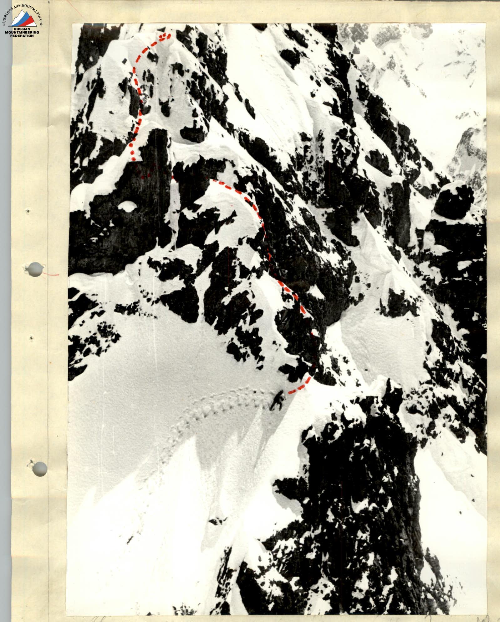
Section R16–R17. Start of ascent to Tsyndyshko South-Western peak
Section R12–R13 of ascent to Tsyndyshko Main peak