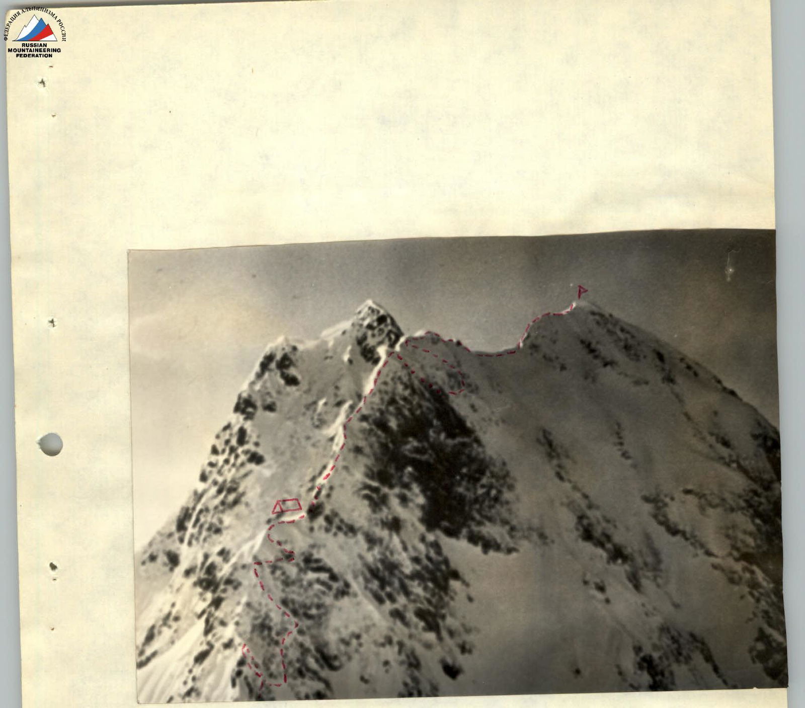
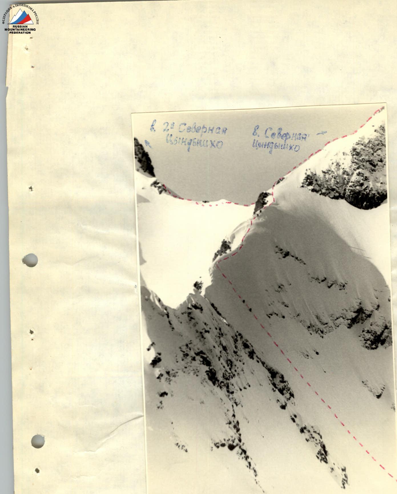
Ascent to Tsyndyshko 2nd North peak via the North edge
Group composition
- Gorshenev K.A. — 1st sports category — leader, participant
- Gorbachevsky A.D. — 1st sports category, instructor (No. 2584)
- Volkovsky V.Z. — 2nd sports category, participant
- Semenov M.I. — 2nd sports category, participant.
Day one (approach to the route)
April 28, 1974
Departure from the base camp at Kardyvach lake at 15:00, upwards along the right bank (in the direction of travel) of the Upper Mzymta river to a group of large boulders beneath the walls of Layub Eastern peak. Then, upwards to the right across a wide snowy slope with rocky outcrops, leading to a saddle beneath Northern Tsyndyshko peak. The journey from the base camp takes 3–3.5 hours. Overnight stay on the saddle. From here, the beginning of the route is visible. This part of the path was prepared: steps were trodden to the ridge connecting to Northern Tsyndyshko peak.
Day two
April 29, 1974
From the overnight stay, follow the trodden steps up the deep snow with a slope of 45–50° to the ridge and along it to the right, towards Northern Tsyndyshko peak. The length of this section is 300 m, and it takes 40 minutes to complete. Along the narrow snowy ridge (simultaneous movement) to a wide snowy slope, and then to rocks of moderate difficulty, traversed simultaneously, and further to the summit of Northern Tsyndyshko. From the overnight stay to the summit — 2.5 hours of walking. From the summit, descend along a steep 35–45° snowy slope, to the left of a rocky outcrop (1.5 ropes). From it, descend to the saddle between Northern and 2nd Northern Tsyndyshko — 1 rope down deep and steep 40–45° snow.
R0–R1
From the saddle, through deep loose snow to the slopes on the ridge. Across rocks of moderate difficulty (4 m) and from them, traverse to the right beneath a large rocky outcrop. The length of this section is 50 m. Time taken — 40 minutes. Belay via outcrops and ice axe. Slope steepness is 50°. To the right of the outcrop, straight up through deep snow (50°), then across rocks dusted with 20 cm of snow (rock steepness 45–50°) to a нависание (overhang). From it, leftwards and along a steep snowy ledge (4 m), then across rocks (2 m) and along a snowy crest to the ridge. Belay point. The length of this section is 40 m, time taken — 1.5 hours. Belay via ice axe, pitons, and outcrops. 4 pitons were hammered in. Section steepness — 50°.
R2–R3
Then, across a rocky crest, descend through difficult rocks covered with flow ice (70°) — 2.5 m — and traverse through deep snow "careful of cornices" — to beneath a wall. Difficult rocks (15 m) with a steepness of 70–75° are traversed with piton belay. After the wall, along a rocky crest slightly dusted with snow — to beneath нависающие скалы (hanging rocks).
The length of this section is 40 m. Time taken — 2.5 hours. Belay via outcrops and pitons. 5 pitons were hammered in. Steepness — 70°.
R3–R4
The нависание (overhang) is bypassed to the right across a steep (80°) difficult wall with an exit to a rocky, then snowy crest (45°). Along the crest — to a large snowy drift.
The length of this section is 30 m. Time taken — 2 hours. Belay via outcrops and pitons. 2 ice pitons were used as rock pitons. Rope pulling for rucksacks was applied. This is the only place suitable for a tented bivouac on the completed part of the route. 210 m of the route was covered in a day. 11 pitons were hammered in.
Day three
April 30, 1974. From the overnight stay, ascend through deep steep snow to a snowy crest and to the right of it (cornices) — to rocks of moderate difficulty. Then, along a rocky-snowy ridge — to a large snowy cap with rocky outcrops to the right — below. The length of this section is 140 m. Time taken — 5 hours, 5 pitons were hammered in. Belay via outcrops and pitons. Steepness — 45–50°. A convenient place for a bivouac. Then, traverse to the right and across rocks of moderate difficulty (50–60°) — to a snowy ridge with minor rocky outcrops. 1 piton was hammered in. Across snow, to the right of the ridge (cornices!) without significant height gain — approach a rocky wall covered with flow ice. The length of this section is 100 m. 1 piton was hammered in. Time taken — 40 minutes.
R6–R7
Up a 15-meter wall (80°), difficult climbing. Piton belay. Then, along a snowy ridge without significant height gain — to the summit. The length of this section is 70 m. Time taken — 1 hour. 4 pitons were hammered in.
- The summit is a snowy dome (with a cornice on the western side). The control cairn is located in rocks 15 m from the summit to the west.
Descent
May 1, 1974.
R7–R8
Descent from the summit along the ridge towards Tsyndyshko Main peak to a жандарм (gendarme). Overnight stay. From the gendarme, descend along a narrow couloir, sticking to its left side, towards the base camp. Upon reaching the junction of our couloir with a wide couloir coming from Tsyndyshko Main peak, traverse it. Behind a small outer crest lies a very wide (40 m) couloir. This couloir is like one huge groove with wall steepness of 70°. After passing this "gutter," begin descent into the 3rd couloir from "our" couloir. Characteristics of the couloir:
- steepness: 40–45°,
- length: 350 m,
- time taken: 3 hours,
- belay: piton and ice axe,
- 5 pitons were hammered in.
The couloir contains icy grooves. It leads to a plateau beneath Tsyndyshko pass. For safety, descent through the couloir should be done early (3:00–4:00).
From the plateau to the base camp — 2 hours of walking.
Ascent to Northern Tsyndyshko peak
Table of main characteristics of the ascent route to Tsyndyshko 2nd North peak via the North edge
Route length — 450 m, including complex sections — 55 m. Steepness of complex sections — 70°.
| Date | Sections traversed | Average steepness of section | Length of section | Characteristics of sections and passage conditions | Technical difficulty | Belay method | Weather conditions | Departure time | Time taken | Pitons hammered in (rock) | Pitons hammered in (ice) | Overnight stay |
|---|---|---|---|---|---|---|---|---|---|---|---|---|
| April 28, 1974 | R0–R1 | 50° | 50 m | Broken rocks, deep snow. Ascent through snow in 3 pitches, climbing of moderate difficulty | 1Б | Through outcrops, ice axe | Clear | 9:00 | 40 min | — | — | — |
| R1–R2 | 55° | 40 m | Steep snow, broken rocks. Climbing of moderate complexity | Moderate complexity | Piton belay, through outcrops | — | 1 h 30 min | 4 | — | — | ||
| R2–R3 | 70° | 40 m | Broken rocks. Difficult climbing | Difficult climbing | Piton belay, through bend | — | 2 h 30 min | 5 | — | — | ||
| R3–R4 | 60° | 30 m | Rocks, deep snow. Difficult climbing, through snow in 3 pitches | Difficult climbing | Piton belay, through outcrops | — | 2 h | 9 | 2 | — | ||
| April 29, 1974 | R4–R5 | 45–50° | 140 m | Rocks, snow. Moderate climbing, partly difficult | Moderate climbing | Pitons, through outcrops | — | 5 h | 5 | — | Tented bivouac | |
| R5–R6 | 50–60° | 100 m | Rocks, deep snow. Difficult climbing | Difficult climbing | Through outcrops, piton | — | 40 min | 1 | — | — | ||
| R6–R7 | Wall 15 m 80° | 70 m | Rocks with ice, snow. Difficult climbing | Difficult climbing | Piton belay | — | 1 h | 4 | — | — |