Peak 3118 (Ayyuly)
Route: via the south ridge
Category: 1B (combined)
Leader: A. Lyapunov
Western Caucasus, Arkhyz, Irkis valley, north-eastern spur of the Arkasar ridge — Gabulu ridge, Ayyuly tract
Section in KMGV — 2.1.
Report
On the first ascent of the climbing route to Peak 3118 (Ayyuly) as part of the "Third stage of the Cup of NP «Sauk-Pay» — «Irkis-2015»" climbing competition (category "First ascents") in May 2015.
Route: via the south ridge
Category: (approximately) 1B (combined)
Region: Karachay-Cherkess Republic
Mountain country: Western Caucasus
Gorge: Irkis valley
Ridge: north-eastern spur of the Arkasar ridge (Gabulu ridge), Ayyuly tract
Peak: 3118 m (Ayyuly)
Route: via the south ridge
Level of complexity: 1B category (combined) (approximately)
Prepared by: A. Lyapunov, S. Zhuravlev
May 2015.
Ayyuly tract
The Ayyuly tract is located in the upper reaches of the Belaya River (Ayyuly), a left-bank tributary of the Psysh River, Irkis valley, on the eastern slope of the southern part of the north-eastern spur of the Arkasar ridge (Gabulu ridge).
The Ayyuly tract is a pronounced mountain horseshoe formed by the south-eastern and eastern spurs of the Gabulu ridge. The nodal peaks and passes do not have official names, but each has traditional names established in guidebooks and guide-books.
The mountain horseshoe of the Ayyuly tract (from left to right):
- 2989 m (peak of the Caucasian Mountaineering Society)
- Tolyatti pass
- 3145 m (Dorbun-Kaya)
- Dorbun pass
- 3213 m (Dukka-Bashi)
- Oleniy pass
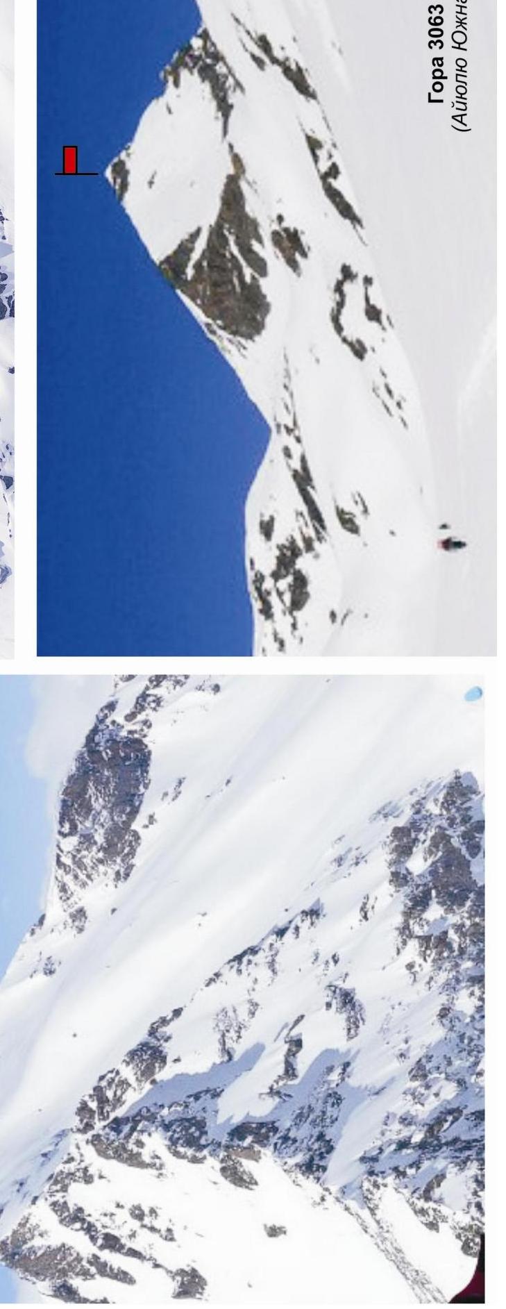
- 3063 m (Ayyuly South)
- Ayyuly pass
- 3118 m (Ayyuly)
The ascent to the tract goes along a mountain trail along the Belaya River (Ayyuly) to the lake, which is the source of the river. There is a shepherd's hut near the lake, used by shepherds in the summer. In the off-season, the hut can be used by climbers as temporary shelter in case of bad weather.
Characteristic features of the peaks of the Ayyuly tract are a long approach with a sharp gain in height and rock towers made of dense rocks with small but technically complex sections.
- Increased avalanche danger during the off-season
- Abundance of snow hanging cornices on rocky ridges
Due to the large height difference (over 1500 m) from the Irkis valley, ascents to the peaks of the Ayyuly tract are conveniently done with an approach. Camps in the Ayyuly tract are comfortable and have drinking water available year-round.
As part of the "3rd stage of the Cup of NP «Sauk-Pay–2015»" climbing competition (category "First ascents"), three first ascents were made to the peaks of the Ayyuly tract:
-
p. 3118 (Ayyuly) via the south ridge — 1B category
-
p. 3063 (Ayyuly South) via the north ridge — 2A (2B?) category
-
p. 3063 (Ayyuly South) via the east counterfort — 3A category
In the Ayyuly tract, due to the high avalanche danger of the slopes, the peak 3214 (Dukka-Bashi) — the highest peak of the tract — remained undeveloped. For the same reason, ascents to peaks 2989 (peak of the Caucasian Mountaineering Society) and 3145 (Dorbun-Kaya) were made from a neighboring gorge — the Amanauz valley.
Note: reports on the first ascents are attached.
Promising climbing routes in the Ayyuly tract:
- 3214 (Bolshaya Dukka) via the NE ridge (approximately 1B–2A).
- 3214 (Bolshaya Dukka) via the SE counterfort (approximately 1B–2A).
- 3087 (Bolshaya Dukka SE) via the N slope (approximately 1B–2A).
- 3087 (Bolshaya Dukka SE) via the NE ridge (approximately 1B–2A).
- 3117 (Dorbun-Kaya Main) via the SW ridge (approximately 2A–2B).
- 3117 (Dorbun-Kaya Main) via the N counterfort (approximately 3A–3B).
- 3117 (Dorbun-Kaya Main) via the NW ridge (approximately 2A–2B).
- 3117 (Dorbun-Kaya C) via the N counterfort (approximately 3B–4A).
- 2089 (peak of the Caucasian Mountaineering Society) via the NE ridge
(approximately 2A–2B). MAP FRAGMENT: 1 cm — 500 m. APPROACH SCHEME TO THE
AYYULY TRACT
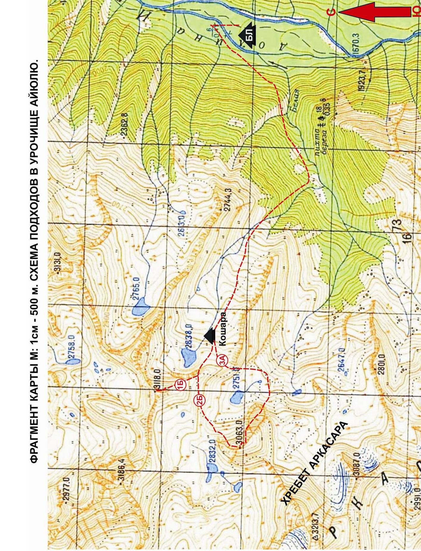 Western
Caucasus. Arkhyz mountain region. Irkis valley. North-eastern spur of the
Arkasar ridge (Gabulu ridge). Belaya River (Ayyuly) valley. Ayyuly tract.
Overview of promising climbing routes
Western
Caucasus. Arkhyz mountain region. Irkis valley. North-eastern spur of the
Arkasar ridge (Gabulu ridge). Belaya River (Ayyuly) valley. Ayyuly tract.
Overview of promising climbing routes
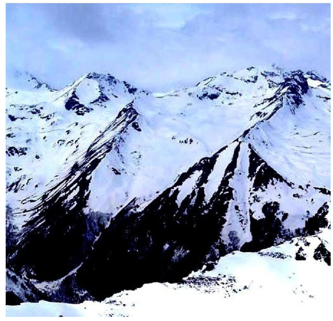
Photo from the Ayyuly tract. May 2015
g.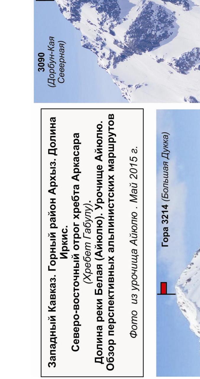
Passport
- Section number according to KMGV — 2010 — 2.1.
Western Caucasus, mountain region — Arkhyz, Irkis valley, north-eastern spur of the Arkasar ridge (Gabulu ridge), Ayyuly tract
- Name of the peak: 3118 (Ayyuly)
- Height: 3118
- Route: via the south ridge
- Category of complexity: 1B
- Character of the route — combined.
- Height difference of the route:
From the base camp (mouth of the Belaya River (Ayyuly)) — 1400 m; from the Ayyuly pass — 820 m
8. Length of the route:
Total length of the technical part (from R1 — Ayyuly pass) — 1100 meters
- Length of sections of the highest category:
1 c. — three sections — 1100 meters; 2 c. — 0 sections — 0 meters; 3 c. — 0 sections — 0 meters; 4 c. — 0 sections — 0 m; 5 c. — 0 sections — 0 m; 6 c. — 0 sections — 0 m
- Average steepness: total route — 35°
11. Number of pitons used:
Total number used on the route:
- rock pitons — 0
- chocks — 0
- stationary bolt pitons — 0
- ITO — 0
- removable bolt pitons — 0.
Number of pitons left on the route: total — 0; including bolt pitons — 0.
- Exit to the route (from the shepherd's hut) — 6:00, May 3, 2015.
Exit to the summit — 11:00, May 3, 2015. Return — 15:00, May 3, 2015
-
Team's walking hours: — 8 hours.
-
Leader: Alexander Lyapunov (Master of Sports of the USSR, instructor-methodologist 2nd category, Sevastopol).
Participants:
- Konstantin Zuev (Samara, 3rd sports category)
- Lyubov Mikhailova (Samara, 3rd sports category)
- Alexander Paramonchev (Samara, 3rd sports category)
- Coach: Sergey Zhuravlev (Candidate for Master of Sports, instructor-methodologist 1st category).
Analogous routes:
- Peak Zimniy — 1B category (Adyr-Su)
- Cheirechenko peak via the east ridge — 1B category (Tsey)
- Kajdžany (M) from the ridge — 1B (Kazbek region)
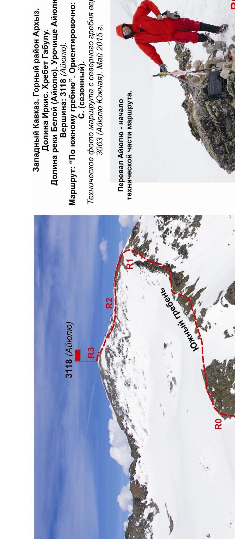
Western Caucasus. Arkhyz mountain region.
- Irkis valley
- Gabulu ridge
- Belaya River (Ayyuly) valley
- Ayyuly tract
- Peak: 3118 m (Ayyuly)
- Route: "Via the south ridge"
- Approximately: 1B category (seasonal)
Technical photo of the route from the north ridge of peak 3063 m (Ayyuly South). May 2015.
Ayyuly pass — the beginning of the technical part of the route.
Approach to the start of the route (R0–R1 — Ayyuly pass saddle):
- From the base camp at the mouth of the Belaya River — 4–5 hours
- From the shepherd's hut in the Ayyuly tract — 1–1.5 hours
R0 — Ayyuly pass saddle marked with a cairn and a memorial plaque.
Section R0–R1 — destroyed rocky ridge. Length — 600 m, steepness 2–30 degrees. Level of complexity — 1 category. With elements of 2 category (rock blocks).
Section R1–R2 — destroyed rocky ridge. Snow-covered slabs.
Length — 300 m. Steepness — 30–50 degrees. Level of complexity — 1–2 category. With elements of 2+ category (snow-covered slabs).
Section R2–R3 — exit to the summit dome. Snow-covered large-block scree.
Length — 200 m. Steepness — up to 30 degrees. Level of complexity — 1 category.
DESCENT: via the ascent route.
Description of the peak
Peak 3118 (Ayyuly) is located in the southern part of the north-eastern spur of the Arkasar ridge (Gabulu ridge), in the upper reaches of the Belaya River (Ayyuly) valley, in the Ayyuly tract north of the Ayyuly pass. The peak is marked on the map with a height mark of 3118. The name of the peak Ayyuly (as well as the passes) is unofficial but established, given by the name of:
- the tract,
- the river,
- the pass
for identification of the peak.
Peak 3118 (Ayyuly) in the Ayyuly tract is easily identifiable as the right-hand peak when ascending to the Ayyuly pass.
Description of the route
Route: "Via the south ridge" — a seasonal ridge characteristic educational and sports combined route of 1B category, with a full range of natural obstacles corresponding to routes of this level.
The south ridge is easily identifiable and simple to find. The route is logical and unambiguous — from the pass to the summit, there are no problems with orientation.
Equipment
For the ascent, a sports detachment of 6 people will need the following special equipment on the route:
Personal:
- Standard equipment
- Crampons
- Ice axe
Group:
- Main rope 10 mm — 3×50
- Rock hammer — 1 pc
- Rock pitons — 4 pcs (in case of unforeseen descent in case of worsening weather)
- Chockstones — 4 pcs
- Friends — 0 pcs
- Ice screws — 0 pcs
- Quickdraws — 4 pcs
- Slings — 6 pcs
Approach
From the base camp, located near the confluence of the Belaya River (Ayyuly) and the Psysh River, ascend along the left (orographic) bank of the Belaya River (Ayyuly). Go along the right-hand side to the shepherd's hut in the Ayyuly tract. The approach takes 3–4 hours.
The ascent is more conveniently done with an approach from the shepherd's hut. The approach from the hut to the start of the route and the place of organizing the rope teams (Ayyuly pass saddle) takes 1–1.5 hours.
Technical part
The beginning of the technical part of the route is the Ayyuly pass saddle (in the tourist classification, the pass is 1A category). The saddle is clearly pronounced. Near the cairn, a memorial plaque is dedicated to the Heroes — Defenders of the Caucasus during the Great Patriotic War.
Then, ascend along a gentle snow slope (to the right) to the narrowing of the ridge and the transition to the rocky ridge. The rocky ridge is strongly destroyed but clearly visible. Most of the rocky sections are pronounced ridge jendarmes, which are bypassed on the snow with the organization of insurance for rocky outcrops.
The passage does not cause difficulty, as the abundance of rocky relief on the ridge allows the use of:
- relief bends and outcrops for insurance,
- large slings thrown over outcrops.
KEY to the route: there is no pronounced key section on the route. The ridge is unambiguous in complexity and stretches from the pass to the summit dome.
The summit 3118 m (Ayyuly) is clearly pronounced, an osypy cupola. The cairn is located in the center.
Descent: via the ascent route.
Recommendations for instructors
Due to the accessibility of the route in terms of orientation, it can be recommended for educational and sports detachments (NP-1, 2).
Time spent on the route for an educational and sports detachment of average training level (NP-2) — 8–10 hours.
- Western Caucasus
- Arkhyz mountain region
- Irkis valley
- Gabulu ridge
- Belaya River (Ayyuly) valley
- Ayyuly tract
- Peak: 3118 (Ayyuly)
- Route: "Via the south ridge"
- Approximately: 1B category (combined)
- Scheme in UIAA symbols
- May 2015
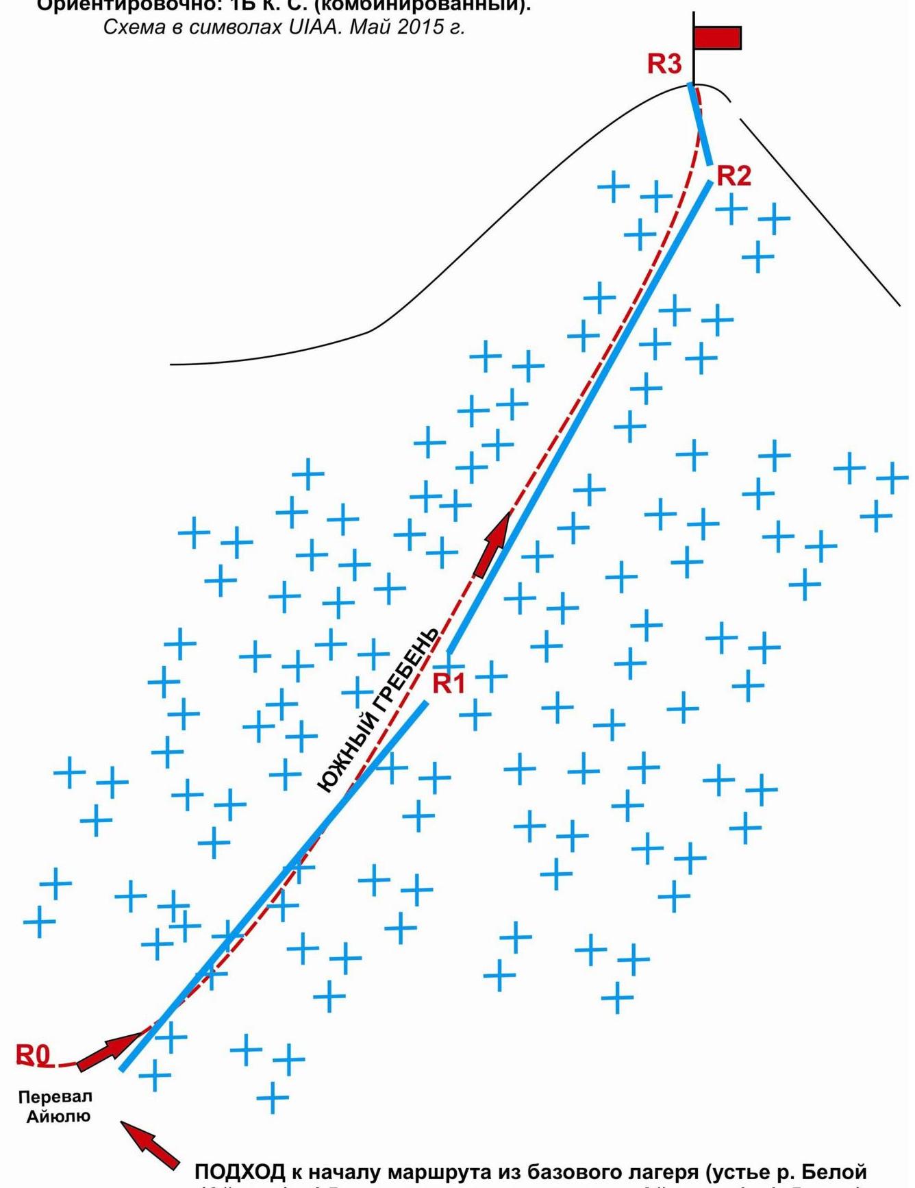
APPROACH to the start of the route from the base camp:
- mouth of the Belaya River (Ayyuly) — 4.5 hours
- from the shepherd's hut in the Ayyuly tract — 1 — 1.5 hours
Western Caucasus. Arkhyz mountain region. Irkis valley. North-eastern spur of the Arkasar ridge (Gabulu ridge). Ayyuly tract. Peak 3118 (Ayyuly)
Route: via the south ridge. Category of complexity: 1B category combined (approximately)
Table of natural obstacles on the route
| APPROACH | From the shepherd's hut in the Ayyuly tract, go right towards the Ayyuly pass (40 min). Then, from the cirque, ascend to the Ayyuly pass. The pass saddle is clearly pronounced. On the pass, near the cairn, a memorial plaque dedicated to the Defenders of the Caucasus during the Great Patriotic War. The technical part begins from the pass cairn (the place of organizing the rope teams). | |||
|---|---|---|---|---|
| R0 | Place of organizing rope teams: Ayyuly pass. | |||
| Characteristics of sections | length | steepness | Level of complexity | Notes |
| Section R0–R1. Ayyuly pass — rocky ridge. Snow. Snow-covered wide ridge. Movement in rope teams on a shortened rope. | 600 | 15-30 | 1,1+ | Used: pitons/chocks: 0/0. No pitons or chocks left. |
| Section R1–R2. Passage of the rocky ridge. Snow-covered rocks. Pronounced rocky ridge. Movement in rope teams on a shortened rope. | 300 | 45–50° B | 1–2-, with elements of 2+ category | Used: pitons/chocks: 0\0. No pitons or chocks left. |
| R2–R3. | 200 | 30° | 1 category | Used: pitons/chocks |
| Ascent to the summit dome. Destroyed scree slope. Movement in rope teams on a shortened rope. | B | 0:00 — no pitons or chocks left | ||
| :-- | :-- | :-- | :-- | |
| R3 — summit 3118 (Ayyuly) | Summit — pronounced scree dome, cairn in the center. | |||
| DESCENT | Via the ascent route. |
Total:
Length of the route
(without approach) — 1100 m
Height difference:
From the base camp — 1400 m
From the Ayyuly pass (R1) — 820 m
Average steepness:
total route — 35–40°
Technical sections:
1 category — three sections — 1100 m
Used/left:
- Pitons — 0/0 pcs.
- Chockstones — 0/0 pcs.
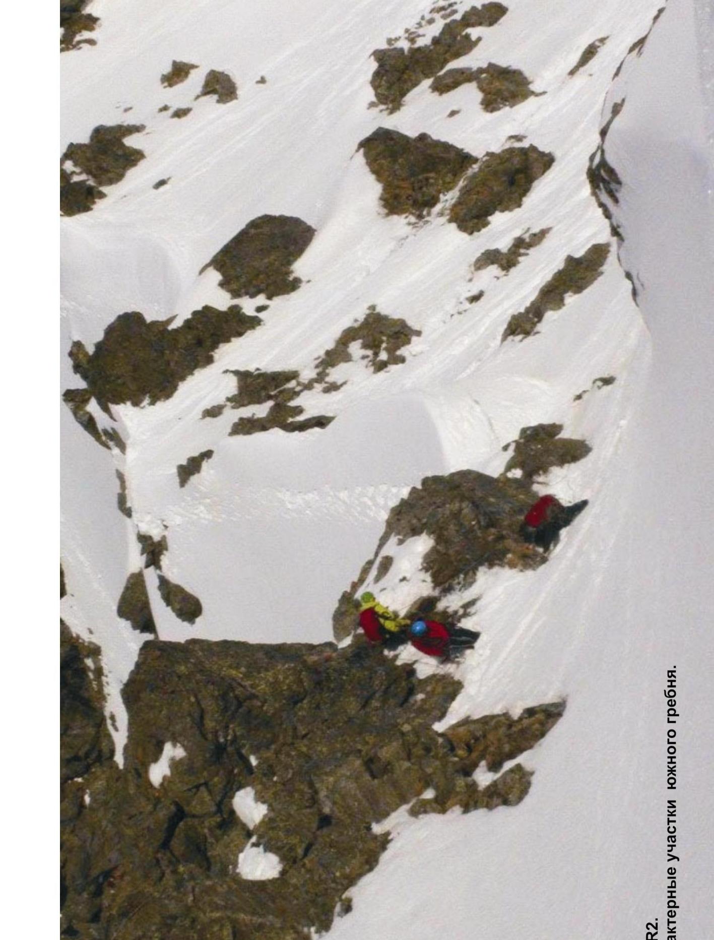
R1–R2. Characteristic sections of the south
ridge.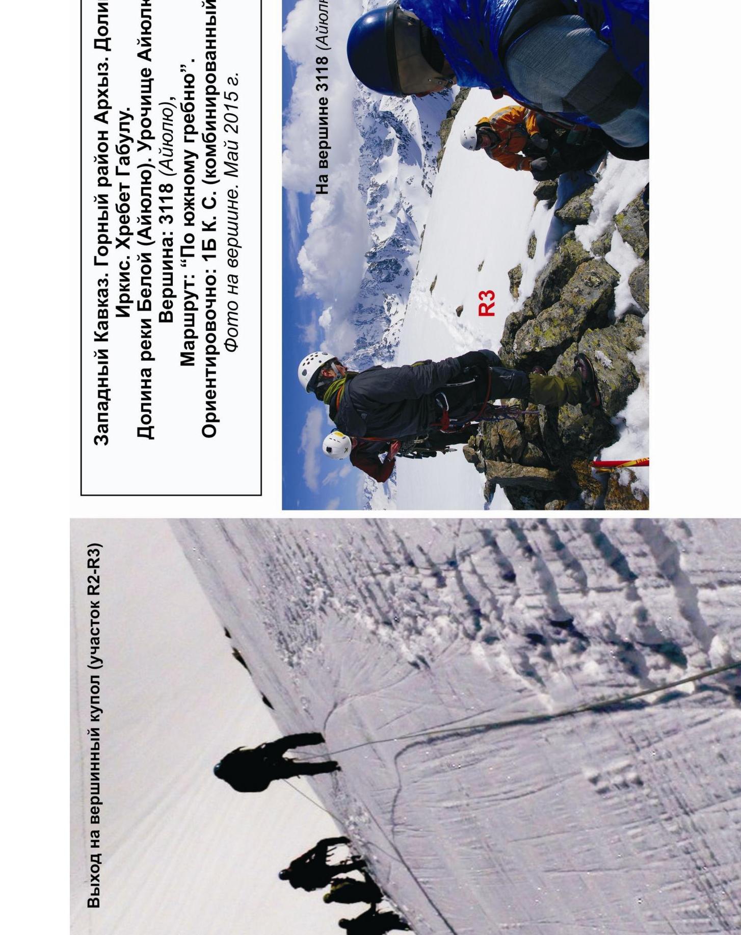
Western Caucasus. Arkhyz mountain region. Irkis valley. Gabulu ridge. Belaya River (Ayyuly) valley. Ayyuly tract. Peak: 3118 m (Ayyuly). Route: "Via the south ridge". Approximately: 1B category (combined). Photo at the summit. May 2015.