
Peak 3226.0 (Dimitrov-100, Taulan)
Route: via the southwestern ridge
Difficulty category — 2A category (combined)
Leader: A. Sotnikov
Western Caucasus, Arkhyz, Orlenok gully, Kara-Jash mountain massif
Section in KMGV — 2.1.
E-mail — ZHUR58@RAMBLER.RU
Report
On the first ascent of the climbing route to peak 3226.0 (Dimitrov-100, Taulan) "Via the southwestern ridge 2A category (combined)". At the alpinism competitions "Cup of Victory" by NP "Club of Northern Travels 'Sauk-Pai'" (class "First ascents") in May 2013.
Region: Karachay-Cherkess Republic Mountain country: Western Caucasus Gully: Orlenok gully Ridge: Kara-Jash mountain massif Peak: 3226.0 (Dimitrov-100, Taulan) Route: via the southwestern ridge. Difficulty level: 2A category (combined) (approximately) Prepared by: A. Sotnikov, S. Zhuravlev. May, 2013.
Description of the peak
Peak 3226.0 is one of the peaks in the northern part of the Kara-Jash ridge. It is located on the territory of the North Caucasian Federal District of the Russian Federation, in the Karachay-Cherkess Republic, Arkhyz mountain region, between the Psyish and Sofia rivers.
Peak 3226.0 is a prominent mountain of the Kara-Jash massif, located northwest of the nodal peak Kara-Jash (3171.0). The peak is easily identifiable from the upper cirque of Orlenok gully. The peak does not have an official name, so it has several conditional tourist-climbing names — which introduces some confusion in identifying the peak.
The most common names are:
- Tourist name — Taulan
- Climbing name — "Dimitrov-100"
Description of the route
The route "Via the southwestern ridge" is a typical sports combined route of 2A category (for the off-season), with a full set of natural obstacles corresponding to routes of this level.
Equipment
To complete the ascent, a sports team of 4 people will need the following special equipment on the route:
personal — standard, crampons and ice axe; public: main rope 10 mm — 2×50, hammer sk. — 2 pcs., pitons sk. — 16 pcs., ice axe — 1 pc., закладные elements — 12 pcs., Friends — 6 pcs., Ice screws — 0 pcs., Quickdraws — 16 pcs., Loops — 10 pcs.
Approach
The ascent is done from a bivouac in the lower cirque of Orlenok gully.
Approach to the lower cirque: from the Taulu glade, cross the Sofia River by a bridge and ascend along the Orlenok gully — first along a logging road, then along a clearly visible trail.
The cirque is well-defined:
- in winter and spring off-season — snowy,
- in summer — overgrown with high-altitude vegetation.
The height of the cirque above sea level is 1600 m. The ascent from the Taulu glade to the cirque takes 1.5–2 hours.
In the lower cirque of Orlenok gully, there are convenient places for tents with:
- water (streams),
- firewood,
- dry areas that become snow-free by the end of April — beginning of May.
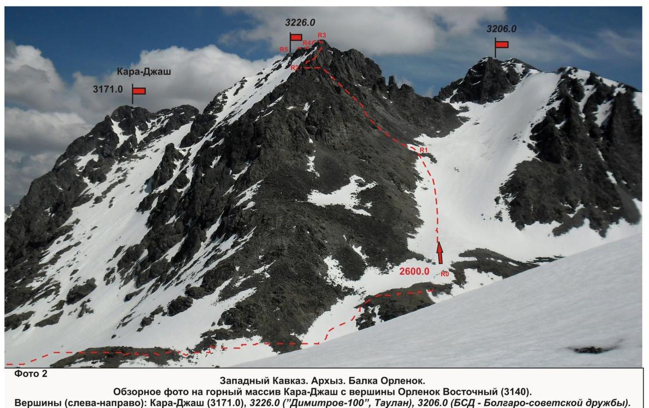
From the base camp in the lower cirque of Orlenok gully, ascend along a distinct trail to the upper cirque and move to the fourth (from the left) pronounced couloir. This couloir leads to the saddle between peaks 3226 (Taulan, "Dimitrov-100") and 3206 (BSD).
The approach from the campsite in the lower cirque of Orlenok gully to the start of the route — the base of the couloir leading to the saddle between peaks 3226 (Taulan, "Dimitrov-100") and 3206 (BSD) — takes about one and a half to two hours.
In the panorama of the upper cirque of Orlenok gully, peak 3226.0 (Taulan, "Dimitrov-100") is easily identifiable as a prominent mountain (to the right) from the nodal peak of Orlenok gully — Kara-Jash (3171).
Technical part
The route begins with an ascent up a snowy slope in the left part of a wide couloir. Then ascend up scree slopes to the entrance to a narrow snow-scree couloir "Gutter". Then:
- move up the couloir,
- exit to the southwestern ridge,
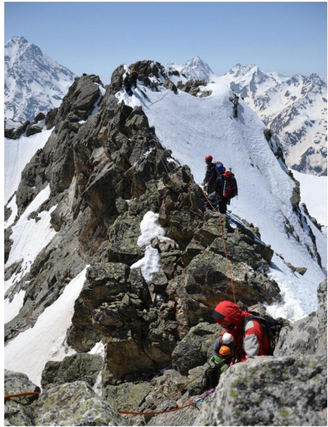
- continue along the jagged, destroyed ridge until it joins the southern ridge.
The key part of the route is the ascent to the summit tower along the jagged rocky ridge. Rockfall danger is subjective. In the off-season, there may be ice on the rocks.
After passing the key section — exit to a simple rocky ridge leading to the summit.
The summit is clearly defined. A cairn is easily found. Descent from the summit:
- is done via the ascent route.
Recommendations for the instructor
Due to the accessibility of the route for orientation, it can be recommended for both training sports teams (NP-2) and independent sports groups of ranked climbers conducting guided or training ascents.
Time spent on the route for a training sports team of average preparation level (NP-2) — 8–10 hours
PASSPORT
- Section number according to KMGV — 2010 — 2.1.
Western Caucasus, mountain region — Arkhyz, Kara-Jash ridge
- Name of the peak: 3226.0 (Dimitrov-100, Taulan).
- Height: 3226.0
- Route: via the southwestern ridge
- Difficulty category: 2A category.
- Character of the route — combined.
- Height difference of the route: 426 m
- Length of the route: 1200 m
- Length of sections of the highest category:
1 category — 2 sections — 850 m, 2 category — 1 section — 200 m, 3 category — 0 sections — 0 m, 4 category — 0 sections — 0 m, 5 category — 0 sections — 0 m, 6 category — 0 sections — 0 m.
- Average steepness: — 35°.
11. Pitons used:
Total pitons used on the route:
- rock pitons — 0,
- закладки — 0,
- шлямбурных stationary — 0,
- ИТО — 0,
- шлямбурных removable — 0.
Left "piton" on the route: total — 0; including шлямбурных — 0.
- Exit to the route — 5:00, May 3, 2013.
Reached the summit — 12:00, May 3, 2013. Returned to BL — 16:00, May 3, 2013.
- Team's walking hours: — 11 hours.
- Leader: A. Sotnikov (1st sports category, Voronezh).
Team members:
- A. Drogolyub (2nd sports category, Moscow)
- Yu. Semenova (2nd sports category, Moscow)
- Coach: Zhuravlev Sergey Vasilyevich (CMS, instructor-methodologist 1 category, Syktyvkar).
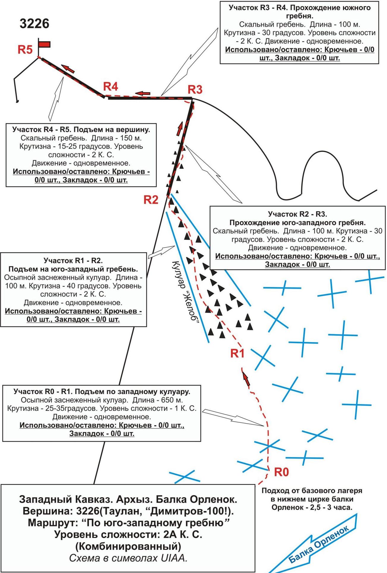
Western Caucasus. Arkhyz. Orlenok gully. Peak: 3226 m (Taulan, "Dimitrov-100"). Route: "Via the southwestern ridge". Difficulty level: 2A category (Combined). Scheme in UIAA symbols.
Western Caucasus, Arkhyz, Orlenok gully, Peak 3226.0 m ("Dimitrov-100", Taulan). Route: "Via the southwestern ridge" 2A (combined) (approximately)
(table of natural obstacles on the route)
| Section | Length | Steepness | Character of relief | Category | Number of pitons/закл. |
|---|---|---|---|---|---|
| R0 — entrance to the couloir leading to the saddle between peaks 3226 and 3206. | On a rocky island, a convenient place to organize rope teams | ||||
| R0–R1 Ascent up a snowy slope to the start of scree | 650 | 25-35 | Snow/rock slope | 1 | 0 / 0 |
| R1–R2 Ascent to the entrance to the narrow couloir "Gutter" | 200 | 35 | Snow, scree | 1 | 0 / 0 |
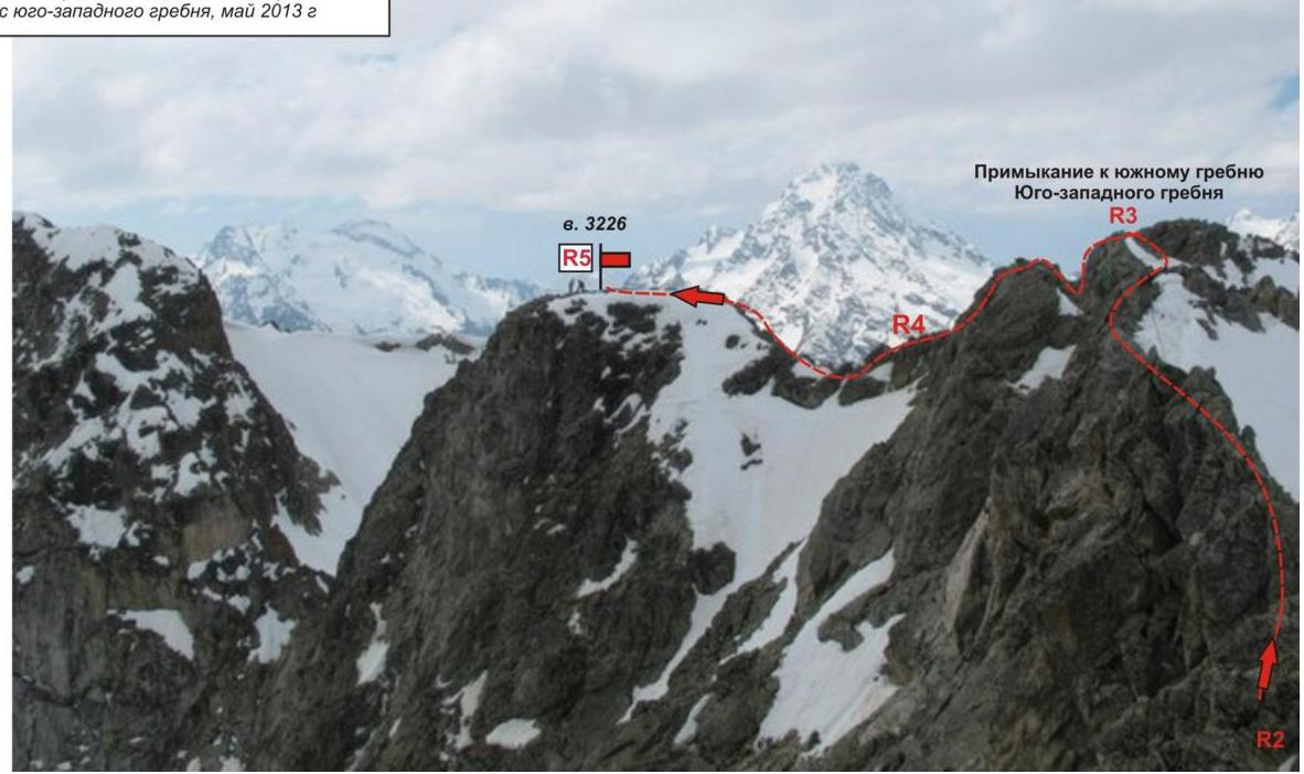
| R2–R3 Ascent up the "Gutter" couloir to the SW ridge | 100 | 40 | Couloir | 2 | 0 / 0 |
| R3–R4 Exit to the junction of the southwestern and southern ridges | 100 | 30 | Rocky ridge | 2 | 0 / 0 |
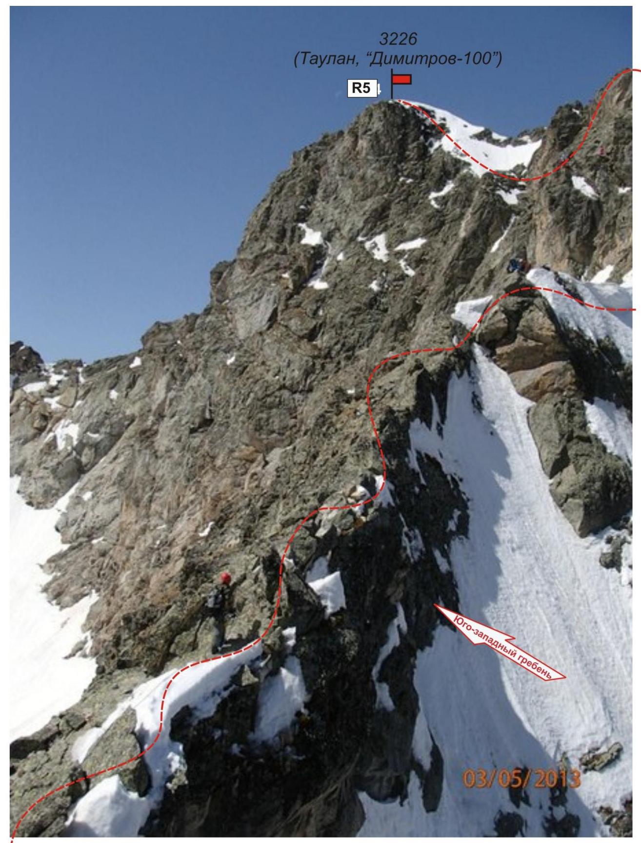
| R4–R5 Passage of the upper part of the southern ridge and exit to the summit | 150 | 15 | Rocky ridge | 2+ with short sections of 3 category | 0 / 0 |
| R5 — summit 3226.0 ("Dimitrov-100", Taulan) | Clearly defined. Cairn easily found. | ||||
| Descent | Via the ascent route |
Total
Length of the route — 1200 m. Average steepness — 35°. Character of relief — combined
Sections:
- 1 category — 2 sections — 850 m
- 2 category — 3 sections — 350 m
Pitons and закладки used: 0/0. Left pitons and закладки: 0/0
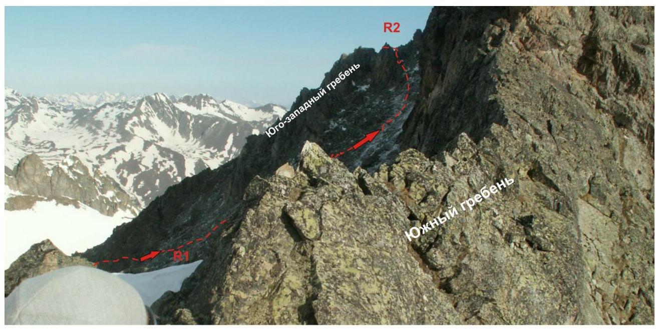
Western Caucasus. Arkhyz. Orlenok gully. Peak: 3226 m (Taulan, "Dimitrov-100"). Route: "Via the southwestern ridge" Difficulty level: 2A category (Combined). Photo-profile of the southwestern ridge from the southern ridge. May, 2013.
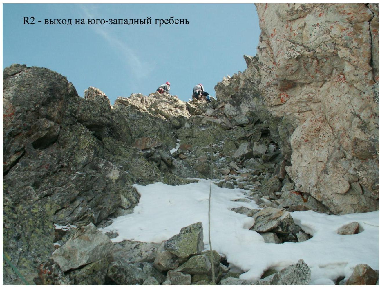
R2. Western Caucasus. Arkhyz. Orlenok gully. Peak — 3226 m (Taulan, "Dimitrov-100"). Route: "Via the southwestern ridge" 2A category (combined). Section: R2–R3. Photo from the southwestern ridge. May, 2013.
Western Caucasus. Arkhyz. Orlenok gully. Peak — 3226 (Taulan, "Dimitrov-100"). Route: "Via the southwestern ridge" 2A category (combined). Section: R3–R4. Photo from the southwestern ridge. May 2013.

Comments
Sign in to leave a comment