Peak 3131 (Goryacheva South Rock)
Route: via the south-eastern ridge
Difficulty category: 2A–2B* (combined)
Leader: V. Babkin
Western Caucasus, Arkhyz, Irkis valley, Arkassara ridge, north-eastern spur (Gabul), Kara-Su tract
Section in the KMGV — 2.1.
Report
On the first ascent of the climbing route to Peak 3131 (Goryacheva South Rock) as part of the climbing competition: "The third stage of the Cup of the North Travel Club 'Sauk-Pai' — 'Irkis-2015'" (class "First Ascents") in May 2015.
- Route: via the south-eastern ridge
- Difficulty category: (approximately) 2A–2B category (combined)
- Region: Karachay-Cherkess Republic
- Mountain country: Western Caucasus
- Gorge: Irkis valley, Kara-Su river valley, Kara-Su tract
- Ridge: north-eastern spur of the Arkassara ridge (Gabul ridge)
- Peak: 3131 m (Goryacheva South Rock)
- Difficulty level: 2A–2B* category (combined) (approximately)
- Prepared by: V. Babkin, S. Zhuravlev
- Month, year: May 2015
Kara-Su Tract
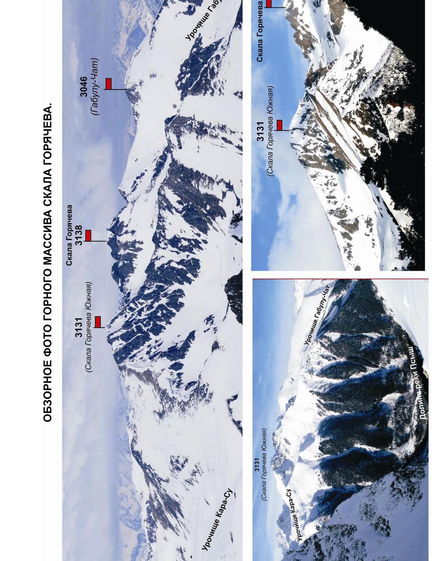
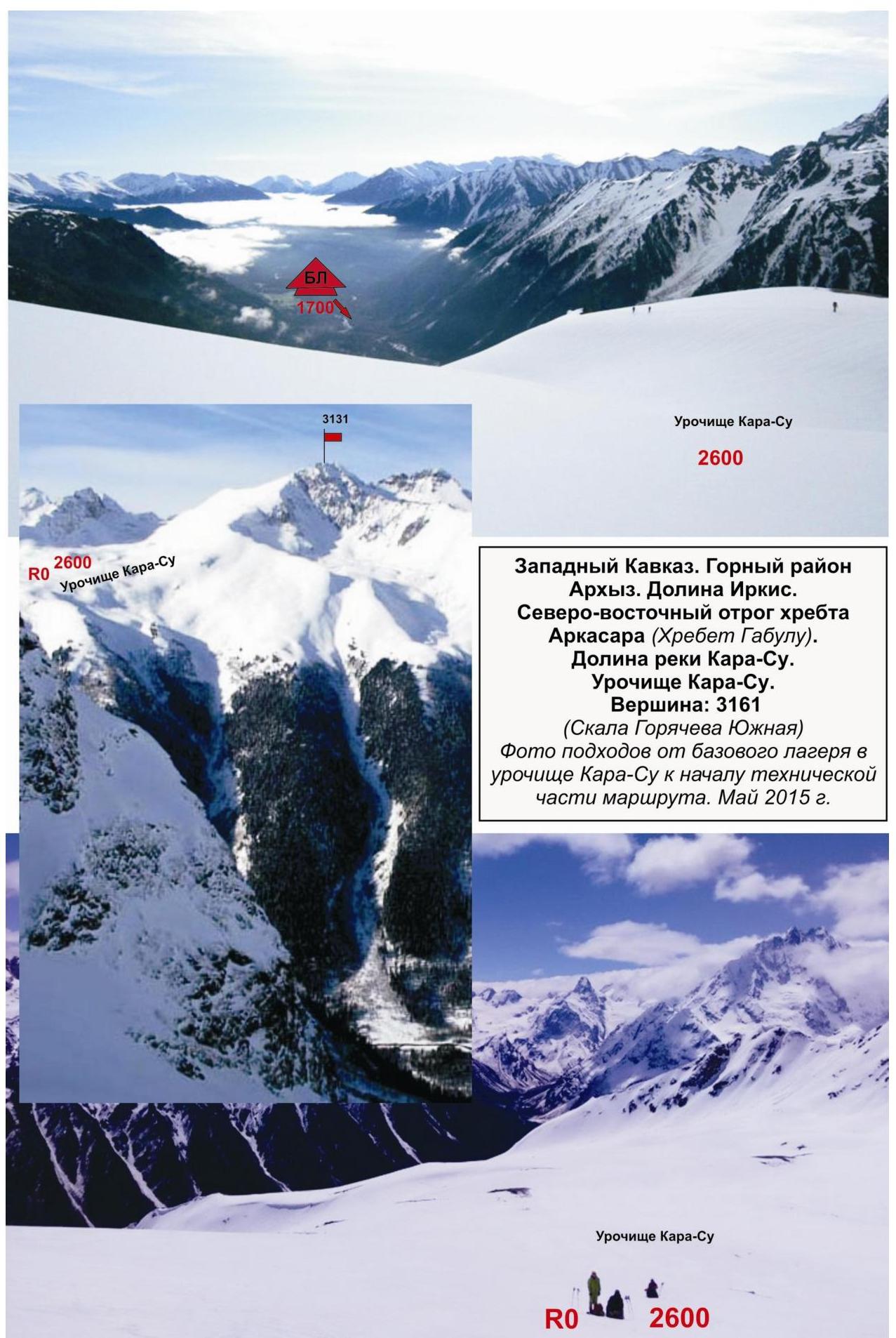
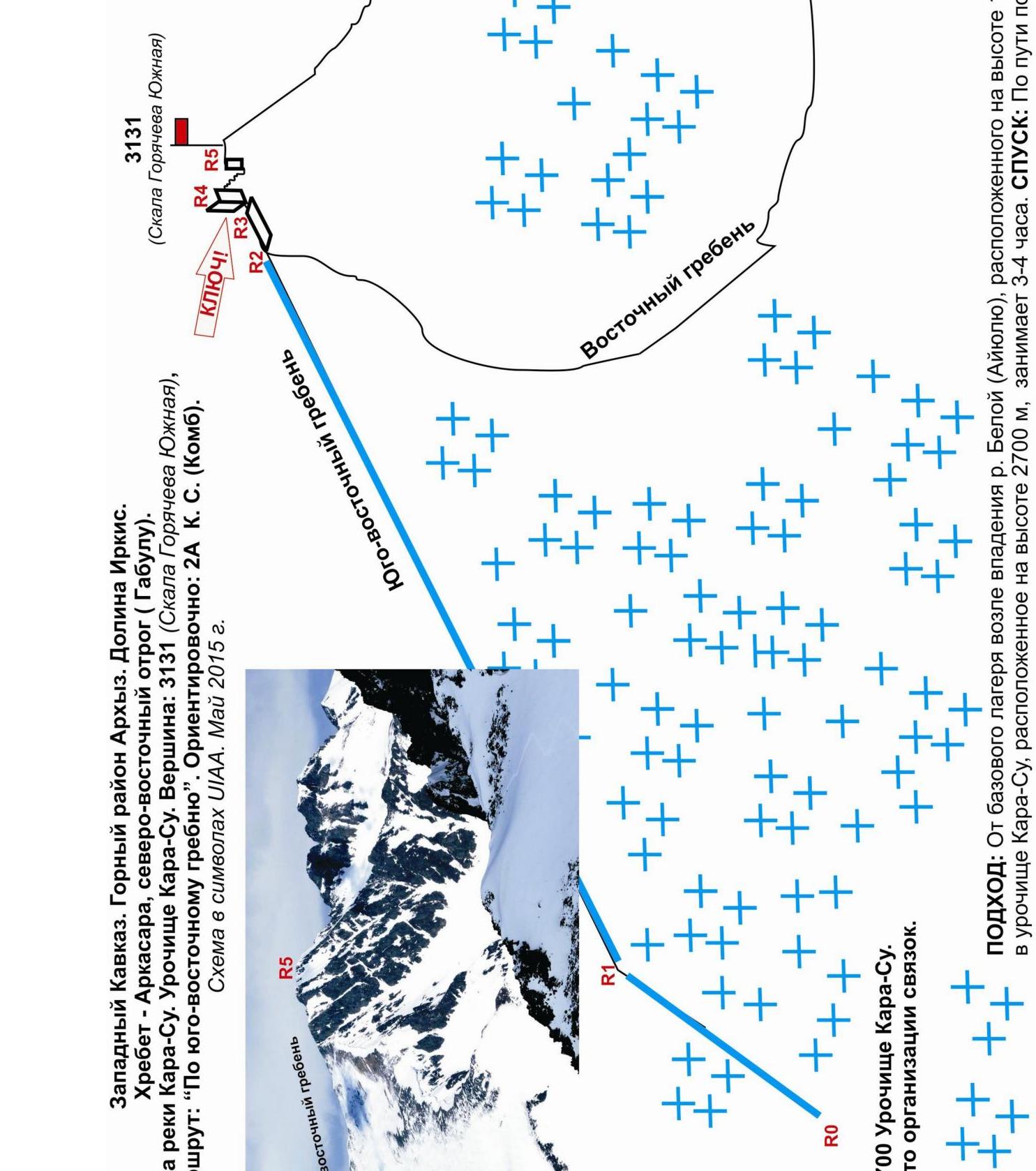
The Kara-Su tract is located on the south-eastern slope of the north-eastern spur of the Arkassara ridge (Gabul ridge) in the upper reaches of the Kara-Su river valley. It is bounded by two eastern nameless mountain spurs that limit the Kara-Su river valley. It is situated at an altitude of 2700 m. There is a large lake in the tract, which is the mouth of the Kara-Su river.
In the tract, there are two pronounced peaks of the north-eastern spur of the Arkassara ridge (Gabul ridge): 3010 m (Karasu) and 3131 m (Goryacheva South Rock). The peaks have height marks on the maps of the Department of Cartography and Geodesy of the Russian Federation and the maps of the General Staff of the Russian Federation, but do not have official names: conditional climbing names are given for identification of the peaks.
As part of the climbing competition "The third stage of the Cup of the North Travel Club 'Sauk-Pai' — 2015", two climbing routes were passed and mastered in the Kara-Su tract:
-
3010 (Karasu) via the south-eastern ridge — approximately 1B category, combined.
-
3131 (Goryacheva South Rock) — via the south-eastern ridge, approximately 2A category, combined. ENLARGED FRAGMENT OF THE GENERAL STAFF MAP OF THE RUSSIAN FEDERATION M- 1 cm — 500 m. (Kara-Su tract).

OVERVIEW PHOTO OF THE GORYACHEVA ROCK MOUNTAIN MASSIF.
Kara-Su Tract
Passport
- Section number according to KMGV — 2010 — 2.1.
Western Caucasus, mountain region — Arkhyz, Irkis valley, north-eastern spur of the Arkassara ridge (Gabul ridge), Kara-Su tract.
- Name of the peak: 3131 (Goryacheva South Rock)
- Height: 3131
- Route: via the south-eastern ridge
- Difficulty category: approximately — 2A–2B* category.
- Character of the route — combined.
- Height difference of the route:
From the base camp (mouth of the Belaya (Ayyulyu) river — 1520 m), from the Kara-Su tract — 410 m.
- Length of the route:
Total length (from the base camp) — 3200 m.
Technical part (from R1 — Kara-Su tract) — 1640 m.
- Length of sections with the highest difficulty category:
1 category — two sections — 1400 m; 2 category — two sections — 190 m; 3 category — two sections — 50 m; 4 category — 0 sections — 0 m; 5 category — 0 sections — 0 m; 6 category — 0 sections — 0 m.
- Average steepness: total route — 35°; technical part — 70°.
11. Number of pitons used:
Total number used on the route:
- rock pitons — 3
- chocks — 6
- stationary pitons — 0
- ITC — 0
- removable pitons — 0 pcs.
Number of pitons left on the route: total — 0; including stationary pitons — 0 pcs.
- Departure for the route (from the base camp) — 4:00, May 8, 2015.
Ascent to the summit — 15:00, May 8, 2015. Return — 19:00, May 8, 2015.
- Team's working hours: — 15 hours.
- Leader: V. Babkin (Yekaterinburg, CMS, instructor-methodologist 2nd category).
Team members:
- Vorobyev Pavel Gennadievich (Voronezh, 3rd sports category)
- Gureev Pavel Gennadievich (Astrakhan, 3rd sports category)
- Zuev Konstantin Alekseevich (Samara, 3rd sports category)
- Mikhailova Lyubov Sergeevna (Samara, 3rd sports category).
- Coach: Zhuravlev Sergey Vasilyevich (CMS, instructor-methodologist 1st category).
Analogous routes:
- Chotchat via the NE ridge 2A category (Adyr-Su)
- Shulgin peak via the SW ridge — 2A category (Tsey)
- Dombay (M) 3 ridge — 2A category (Dombay).
Description of the Peak
Peak 3131 (Goryacheva South Rock) is located in the southern part of the north-eastern spur (Gabul ridge) of the Arkassara ridge, in the upper reaches of the Kara-Su river valley, in the Kara-Su tract.
- The peak is not marked on the kilometer map of the General Staff of the Russian Federation with a height mark, but is marked with categorical height marks on the map of the General Staff of the Russian Federation M: 1 cm — 500 m.
- The name of the peak 3131 — Goryacheva South Rock — is unofficial, given for identification of the peak.
Peak 3131 (Goryacheva South Rock) in the Kara-Su tract is easily identifiable as the right-hand pronounced mountain with a pronounced south-eastern ridge and a rocky tower.
Description of the Route
The route: "Via the south-eastern ridge" — a ridge characteristic training and sports combined route of 2A category, with a full set of natural obstacles corresponding to routes of this level.
The south-eastern ridge is easily identifiable and simple to locate, as it is bounded on the right by the Kara-Su tract.
The route is logical from the ascent to the ridge and to the summit, and does not cause problems with orientation.
Equipment
For the ascent, the sports section consisting of 6 people requires the following special equipment on the route:
-
Personal — standard, crampons, ice axe.
-
Public:
- main rope 10 mm — 3×50 m
- rock hammer — 2 pcs.
- rock pitons — 4 pcs. (in case of bad weather, for rappelling or dülfering)
- chock stones — 6 pcs.
- friends — 0 pcs.
- ice screws — 0 pcs.
- quickdraws — 16 pcs.
- slings — 4 pcs.
Approach
From the base camp located near the confluence of the Belaya (Ayyulyu) river and the Pshysh river, descend along the dirt road to the Kara-Su river. Then:
- along the logging road,
- then along the steep snowy slope, bypassing the canyon in the middle part of the narrow Kara-Su river valley,
- ascend above the forest boundary and further — to the Kara-Su tract.
On the stony island under the south-eastern ridge, it is convenient to organize rope teams. The approach takes 3–4 hours.
Technical Part
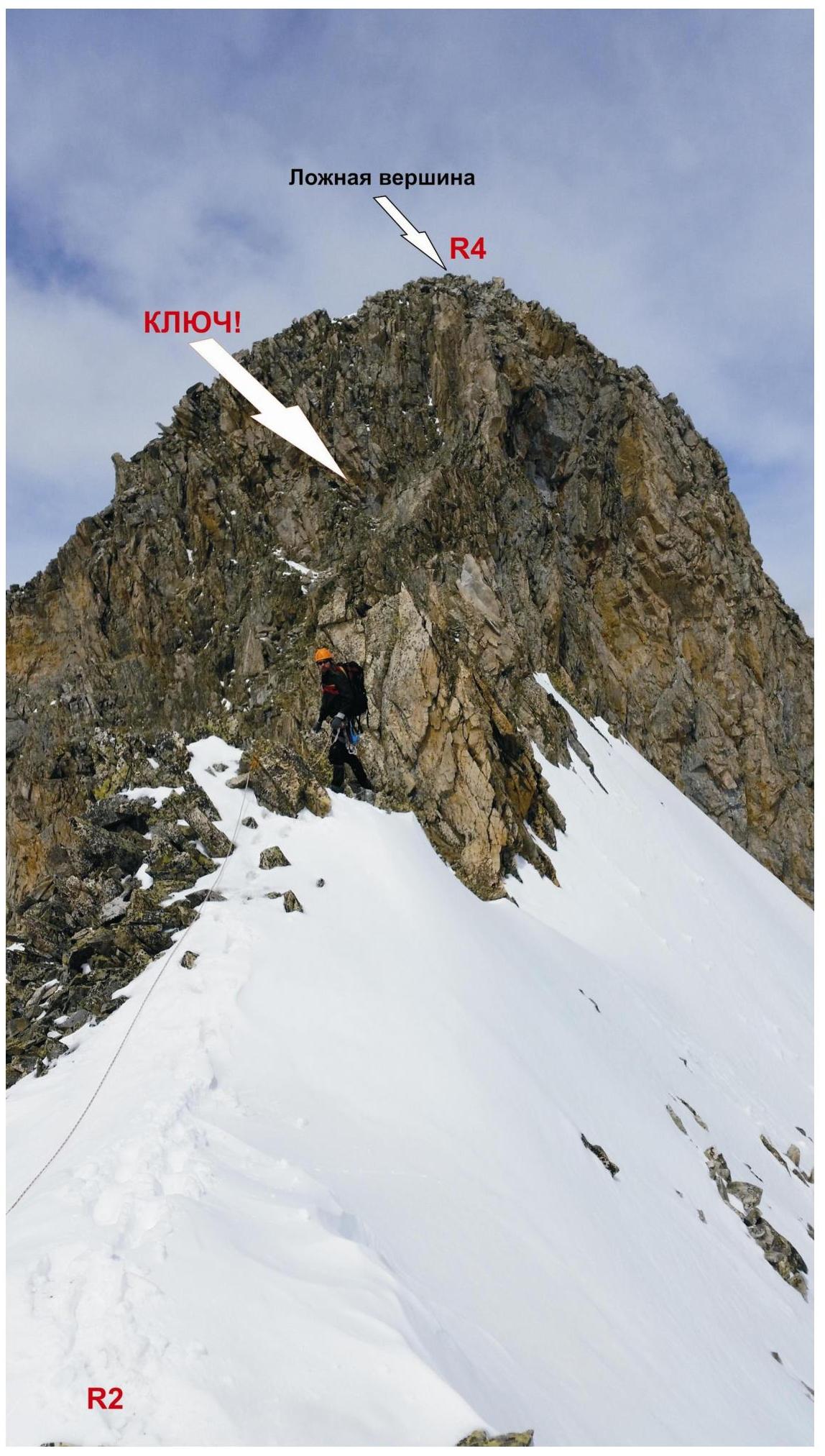
The route begins with an ascent along a steep snowy slope to the south-eastern ridge of peak 3131 m (Goryacheva South Rock). Movement is simultaneous with the use of ice axes for self-arrest, along a slope turning into a pronounced ridge, to the junction with the eastern ridge.
Then, ascend along simple rocks to a rocky shoulder under a pronounced rocky tower of the false summit. The ascent to the rocky tower of the false summit is the key to the route.
The key to the route — ascent to the rocky tower of the false summit:
- First, a series of ledges leads to a smoothed rocky wall.
- Under the rocky wall, there is a convenient place for a stance, as the ropes from the rocky shoulder are not long enough to pass the key.
- The smoothed wall is climbed using friction and leads under a pronounced internal angle.
- Ascend along the internal angle to the rocky ridge.
Then, traverse along the ridge to the false summit. Descend from the false summit to a saddle (snow-covered destroyed rocks) and from the saddle, ascend through a short rocky wall (on the left) to peak 3131 m (Goryacheva South Rock).
Peak 3131 (Goryacheva South Rock) — a pronounced rock tower in the ridge. A cairn was built by the participants of the first ascent.
Descent: via the ascent route.
Western Caucasus. Arkhyz mountain region. Irkis valley. Ridge — Arkassara, north-eastern spur (Gabul). Kara-Su river valley. Kara-Su tract.
Peak: 3131 (Goryacheva South Rock) Route: "Via the south-eastern ridge" Approximately: 2A category (Combined)
Scheme in UIAA symbols. May 2015.
Western Caucasus. Arkhyz mountain region. Irkis valley. Arkassara ridge, north-eastern spur (Gabul). Kara-Su river valley. Kara-Su tract. Peak 3131 (Goryacheva South Rock). Route: via the south-eastern ridge. Difficulty category: 2A, combined (approximately).
Table of Natural Obstacles on the Route
| APPROACH | From the base camp near the confluence of the Belaya (Ayyulyu) river and the Pshysh river — descend along the dirt road to the Kara-Su river. Then ascend along the Kara-Su river valley to the Kara-Su tract. Significant height difference: base camp at an altitude of — 1600 m, Kara-Su tract at an altitude of — 2700 m. Ascent to the Kara-Su tract takes 3–4 hours. | |||
|---|---|---|---|---|
| R0 | Location of rope team organization: Kara-Su tract (2700 m). | |||
| Characteristics of sections | length | steepness | Difficulty level | Notes |
| Section R0–R1. Approach under the south-eastern ridge. Snowy cirque. | 300 | 15 | H/K | Used: pitons/chocks — 0/0. No pitons or chocks left. |
| Section R1–R2. Ascent to the south-eastern ridge. Snowy slope. | 400 | 15-20 | 1,1+ | Used: pitons/chocks: 0/0. No pitons or chocks left. |
| Section R2–R3. | 1000 | Up to 30° | 1,1+ | Used: pitons/chocks |
| Passage through a destroyed snow-rock ridge to the junction of the ridges. Heavily destroyed ridge. Simultaneous movement. | 0/0. No pitons or chocks left. | |||
| :--: | :--: | :--: | :--: | :--: |
| Section R3–R4. Ascent to the false summit. KEY to the route — rocky tower of the false summit. 1. Rocky slope and rocky slabs. 2. Smoothed wall. 3. Internal angle. Rappel. Interaction between rope teams. | 40 20 10 | 45 50 70 | 2 — 3 — 3+ | Used: pitons/chocks — 3/6 pcs. No pitons or chocks left. |
| Section R4–R5. Descent to the saddle and ascent to peak 3131 (Goryacheva South Rock). Destroyed rocks with a ridge wall before the summit. Movement with alternate belay. | 150 | 25-40 | 2 | Used: pitons/chocks: 0/0. No pitons or chocks left. |
| R5 — summit 3131 (Goryacheva South Rock) — elevation in the ridge. | Summit — a pronounced large rock tower in the ridge. There is a place for 1–2 teams. Cairn built by the participants of the first ascent. | |||
| DESCENT | Via the ascent route. |
Total:
Route Length
(without the approach from R0) — 2200 m.
Height Difference:
From the base camp — 1600 m. From R0 — 730 m.
Average Steepness:
total route 35°, technical part — 70°.
Technical Sections:
1 category — two sections 1400 m, 2 category — two sections 190 m, 3 category — two sections 30 m.
Used/Left:
Pitons — 3/6 pcs, chocks 0/0 pcs.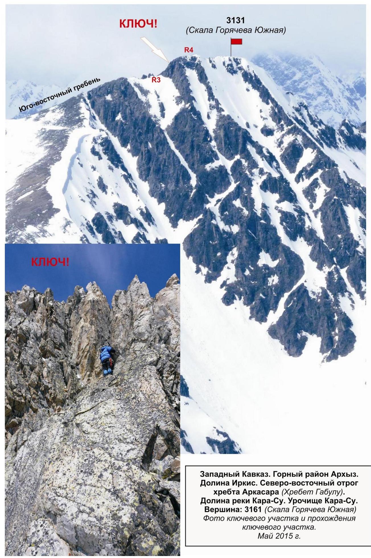
Western Caucasus. Arkhyz mountain region. Irkis valley. North-eastern spur of the Arkassara ridge (Gabul ridge). Kara-Su river valley. Kara-Su tract.
Peak: 3131 (Goryacheva South Rock)
Photo of the key section and passage of the key section.
May 2015. False summit