The summit of PESHTERA is 3070 m and is located in the North-Eastern spur, running from the junction near the summit of Velbashi (3243 m). It rises like a rocky pyramid above the valley of the left tributary of the Sofia River, which flows into the latter near the "Syrzavod" glade.
To the northwest of PESHTERA, separated by a col with an absolute height of 2800 m, are the rocky bastions of the summit named "60th anniversary of KChAO" (2970 m). Both summits are visible from the "Syrzavod" glade, where the base camp was located during the winter alpinism event (see orographic scheme, photo ©).
The 3070 m summit, as an object of first ascent, was proposed by the coaching council of the federation to a group of athletes under the leadership of R.A. Gorda.
The only acceptable approach from the point of view of avalanche safety was the eastern spur of the NE ridge, descending from the Eastern pre-summit of the "60-let KChAO" peak (consultations with candidate of geographical sciences, avalanche specialist VGI in Nalchik, Mr. Runich A.V.).
From the "Syrzavod" glade with an absolute height of 1930 m, descent to the Sofia River and in the area of the mouth of its left tributary - crossing the river in the direction of the Eastern spur, leading to the NE ridge of the "60 let KChAO" summit.
Along the spur, overgrown with forest in the lower part, straight up, leaving avalanche-prone slopes on the right and left. Having gone beyond the forest boundary, continue to move along the watershed line to a group of separate trees and further - to the last spruce, from which the rocks of the spur begin. The mentioned spruce is visible from the "Syrzavod" glade.
Further along the wide rocky spur - exit to the junction point of the NE ridge, having a mark of 2590 m (660 m height difference).
Here is the starting point of the route (2-3 hours of ascent along a pre-organized snow trail).
Route Description
Section R0-R1. Along the left part of the narrow rocky ridge (to the right - cornices) with numerous gendarmes, overcome "head-on", in a team, movement is simultaneous and alternate.
100 m before reaching the base - the wall of the "Bashnya" gendarme, in the lower part of this gendarme - a reddish spot on the background of dark granites (see photo №).
Distance from R0 to R1 - 700 m (2680 m).
Average steepness - 10°, however, it consists of numerous ascents and descents along the snowy narrow ridge.
Insurance through an ice axe and ledges.
Time taken: 1.5-2 hours of walking.
R1 - a pronounced depression in the ridge, from which it is possible to descend into a wide snowy hollow between the summits "PESHERA" and "60-let KChAO".
Above (extremely important! see photo 5) - the line of snow avalanche boards breaking off (see photo № 3). In winter, there is NO other safe path to the summit of PESHERA!!!
Section R1-R2 - The first complex section of the route.
- Dolpher 40-50 m along the rocks ( местами covered with snow), steepness 70° and transition to a steep snowy slope (50°).
- Further 60 m along this slope, in the lower part the slope becomes gentler to 30° (organization of belays is necessary).
- Exit above the line of avalanche breaking off!
When returning:
- Complexity of ascent for the first along the rocks.
- Organization of belays (3 hooks hammered in for organizing a descent station).
Duration: 1.5-2 hours depending on the number of participants. Absolute mark: 2570 m. Height difference: 110 m. See photo № 4.
Section R2-R3. From the hollow-shaped part of the trough valley with deep snow, adhering to the right rocks of the NE ridge of the "60 let KChAO" summit, ascent upwards in the direction of the col between the summits "60 let KChAO" and PESHTERA (900 m, steepness of the first 600 m - 30°, last 300 m when exiting to the col - 50°, absolute mark 2800 m, 2 hours of walking, height difference 230 m). See photo № 5, 6.
Section R3-R4. From the col:
- Descent 10 m to a snowy plateau.
- Along its upper edge, traverse in the direction of the junction of the western ridge of the PESHTERA summit and the eastern ridge of the 3100 summit.
20 m before reaching the col:
- Turn left.
- Move along a gentle snowy and large talus, exiting to the Western ridge (10 m) of the PESHTERA summit. 15-20 minutes, steepness 15°, absolute mark 2840 m.
See photo № BA.
Section R4-R5. At the point of exit to the ridge, turn left and along a not wide, местами snowy ridge move in the direction of the I gendarme - 60 m. Movement is simultaneous.
The first gendarme starts with:
- ascent - 40 m (see photo № 7,19) (55°-60°),
- further along the ridge - 10 m (25°-30°),
- through a 20-meter wall (70°) - exit to I gendarme (15-20 minutes).
Rocks are strong, have good cracks for pitons and chocks, as well as ledges on which reliable insurance can be organized. Rocks are of medium difficulty, almost not snowy. Used:
- 3 pitons,
- 2 chocks,
- 4 ledges.
Movement in interaction.
Section R5-R6. Second complexity section. From the gendarme, descent 4 m to a sharp ridge (10°) and along it 80 m in the direction of the II gendarme.
Rocks are strong, of medium difficulty, a large number of ledges, reliable for insurance organization.
The II gendarme begins with a 15 m wall (75°-80°). Rocks are of medium difficulty. After it - a shallow dip, ending with a 20 m wall (80°) (see photo № 7,4), the last 5 m of which overhang.
Passed by free climbing along the crack on the left. Rocks are monolithic, limited number of cracks for pitons, except for the crack, well used for chocks like "eccentric".
Features of passage:
- Movement along the ridge - simultaneous.
- When passing the wall - alternate.
- 2 pitons hammered in, 3 chocks used and 4 ledges.
- Time taken - 40 minutes.
Section R6-R7. Descent from the II gendarme - 10 m along the line of the pre-summit tower, which is bypassed on the right along a 120 m steep snowy slope (50°) (see photo № 7).
Move along the rocks of the pre-summit tower with simultaneous insurance, through the ledges of the pre-summit tower, exit to the ridge and along it - exit to the summit 40 m (30°). Rocks are snowy.
Height difference: 230 m.
Descent from the summit along the NW ridge to the col between the summits "60 let KChAO" and PESHTERA and further along the ascent path.
During the ascent, 8 pitons were hammered in, 5 chocks used.
Time taken to overcome the route: 8-9 hours.
Descent: 3-4 hours.
Possible bivouac sites:
- On the col.
- Under the pre-summit tower.
At the debriefing, held in the presence of the issuing official, head of rescue and event participants, the ascent was evaluated as a combined first ascent, corresponding to 2B category of complexity in winter conditions.
Recommendations:
- Descent along the NW ridge and further along the ascent path, detour paths are avalanche-prone.
- It is necessary to have 5-6 chocks like "Stopper" and 3-4 like "Eccentric".
- Main rope - 40 m, not less.
Leader
R.A. Gorda
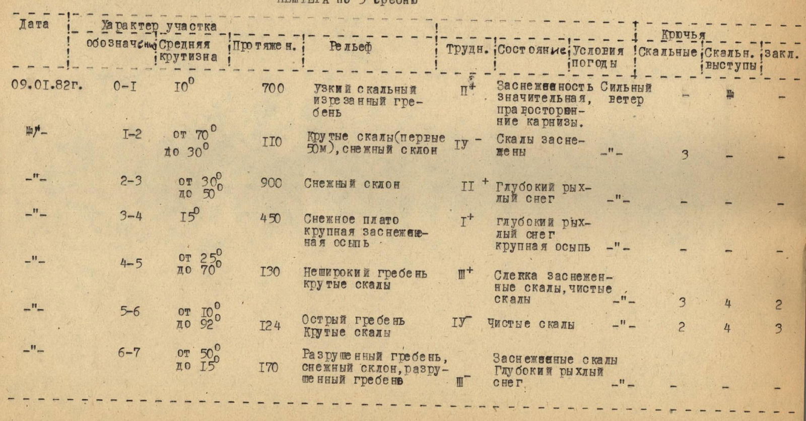
Table of main characteristics of the route of first ascent to the summit of Peshtera by 3B
| Date | Section | Average steepness | Length (m) | Relief | Difficulty | State; Weather conditions | Pitons | Ledges | Chocks |
|---|---|---|---|---|---|---|---|---|---|
| 09 January 1982 | R0-R1 | 10° | 700 | Narrow rocky jagged ridge | 1+ | Significant snow cover, right-hand cornices. Strong wind. | |||
| 09 January 1982 | R1-R2 | 70° to 30° | 110 | Steep rocks (first 50 m), snowy slope | 4 | Rocks are snowy | 3 | ||
| 09 January 1982 | R2-R3 | 30° to 50° | 900 | Snowy slope | 2+ | Deep loose snow | |||
| 09 January 1982 | R3-R4 | 15° | 450 | Snowy plateau, large snowy talus | 1+ | Deep loose snow, large talus | |||
| 09 January 1982 | R4-R5 | 25° to 70° | 130 | Not wide ridge, steep rocks | 3+ | Slightly snowy rocks, clean rocks | 3 | 4 | 2 |
| 09 January 1982 | R5-R6 | 10° to 80° | 124 | Sharp ridge, steep rocks | 4 | Clean rocks | 2 | 4 | 3 |
| 09 January 1982 | R6-R7 | 50° to 15° | 170 | Destroyed ridge, snowy slope, destroyed ridge | Snowy rocks, deep loose snow | ||||
 |