
Passport
- Section number according to KMGV — 2010 — 2.1.
Western Caucasus, mountain region — Arkhyz, Orlenok gully, mountain massif (ridge) Kara-Jash
- Names of peaks: 2900 m (Kara-Jash North-East) — Kara-Jash (3171) — 3170 — 3201 (NRB) — 3226 (Taulan, «Dimitrov-100»)
- Heights of peaks: 2900–3171–3170–3201–3226
- Route: traverse of peaks: 2900 m (Kara-Jash North-East) — Kara-Jash (3171) — 3170 — 3201 (NRB) — 3226 (Taulan, «Dimitrov-100») from north-east to south
- Category of difficulty: 4A
- Character of the route — combined
- Height difference of the route: 970 m
- Length of the route: 2480 m
- Length of sections with the highest category of difficulty:
Sections:
- 1B — 6 sections — 520 m
- 2B — 14 sections — 1490 m
- 3B — 8 sections — 185 m
- 4B — 7 sections — 285 m
- 5B — 0 sections — 0 m
- 6B — 0 sections — 0 m
- Steepness of the route — 60°.
- Number of pitons used:
Total used on the route:
- rock pitons — 5
- chocks — 30
- stationary bolting — 0
- A4 — 5 points
- removable bolting — 0
Left on the route: total — 0; including bolting — 0, chocks — 0.
- Start of the route — 4:00, May 9, 2013.
Reached the peak 3226 (the most remote peak of the traverse) — 17:00, May 9, 2013.
Return to the base camp — 19:30, May 9, 2013.
- Team's walking hours: — 15 h.
- Leader: V. Zakharov (2nd sports category, Moscow).
Participants: V. Rybenko (2nd sports category, Moscow).
- Coach: S. Zhuravlev, title — CMS, instructor-methodologist of the 1st category.
Description of Peaks
The peaks of the mountain massif (ridge) Kara-Jash (3171) are located on the territory of the Caucasian Federal District of the Russian Federation, in the Karachay-Cherkess Republic, Arkhyz mountain region (Orlenok gully), between the rivers Pshish, Sofia, and Orlenok. The nodal peak of the ridge is v. Kara-Jash (3171). The peak Kara-Dash (3171) is a pronounced mountain of the Kara-Jash ridge, easily identifiable from the Taulu meadow, located at the confluence of the Sofia river into the Pshish river. The name of the peak is official, marked on the geographical maps of the Russian Federation (M:1 cm — 1 km), and translates from the Karachay-Balkar language as "Black Prince".
In addition to v. Kara-Jash (3171), the mountain massif (ridge) Kara-Jash includes the following peaks:
- Peak 1
- Peak 2
- Peak 3
- Peak 4
- Peak 5
- Peak 6
Description of the Route
The route "Traverse of peaks: 2900 (Kara-Jash North-East) — Kara-Jash (3171) 3170 — 3201 (NRB) — 3226 (Taulan, «Dimitrov-100») from north-east to south" is orographically logical and technically interesting combined sports route 4A category of difficulty, including most of the peaks of the mountain massif and the most interesting sports-alpinist part of the ridge.
Approach
The ascent is made from a bivouac in the upper cirque of the Orlenok gully. The approach to the bivouac in the upper cirque is not complicated in terms of orientation: from the Taulu meadow, cross the Sofia river by a bridge and ascend along the Orlenok gully — first along a logging road, then along a clearly visible trail.
The cirque is pronounced: in winter and spring off-season — snowy, in summer — overgrown with high-altitude vegetation with two beautiful lakes among small birch and pine groves.
From the Taulu meadow, the ascent to the cirque takes 1.5–2 hours. The cirque has convenient places for tents, with water (streams) and dry areas, freed from snow at the end of April — beginning of May.
The height of the bivouac by the lake above sea level is 2200 m.
From the bivouac in the upper cirque through the pass between the peak Skala Orlenok and the north-western ridge of v. Kara-Jash (per. Gnora) to the upper cirque of the Gnilaya gully. The route begins from the upper cirque of the Gnilaya gully. The approach from the bivouac to the start of the route — the rock block "Orekh" — takes about an hour.
Technical Part
The traverse includes two previously mastered routes:
- 3B (Kara-Jash along the NE ridge, K. Shustov, 2013),
- 3A (the upper, most complex part of the route to v. 3226 along the 3rd couloir and the South ridge, V. Babkin, 2012)
and a previously unmastered section of the massif between these routes.
The first section of the traverse (route 3B category of difficulty).
The traverse begins with:
- ascent along a snowy slope to the north-east ridge;
- movement along the ridge to the approach under the rock wall.
The key point of the route 3B category of difficulty is a very complex, steep, strongly disintegrated rock wall. Subjectively — rockfall hazard!
After passing the key point:
- ascend along a pronounced rock ridge to the peak 2900 m (Kara-Jash North-East);
- descend from the peak 2900 m to the ridge;
- move along a snowy-icy ridge to the saddle;
- from the saddle, pass along inclined slabs and ridge sections to the summit tower of v. Kara-Jash.
The ascent to the summit tower is along a wall with a crack. The wall is complex, but the relief allows organizing a sufficient number of intermediate belay points.
Further, along the pre-summit ridge, exit to the peak Kara-Jash.
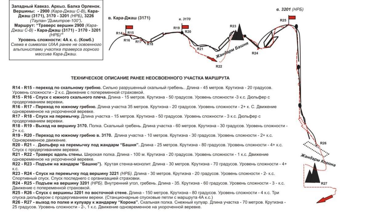
The second (previously unmastered section of the traverse). From the peak Kara-Jash, continue the path along a pronounced ridge and, having organized several small descents, ascend to the peak 3170 (20th Congress of the CPSU). Further — movement along the ridge with descents to the saddle under the big gendarme "Bashnya".
Ascent to the gendarme "Bashnya":
- along a rock wall on the right along the way;
- further descent to the saddle and ascent from the saddle to the peak 3201 (BDS).
From the peak 3201 (BDS) — a complex descent:
- 3 rappels with pulling through the wall (route 4A category of difficulty);
- stationary loops are used on the descents.
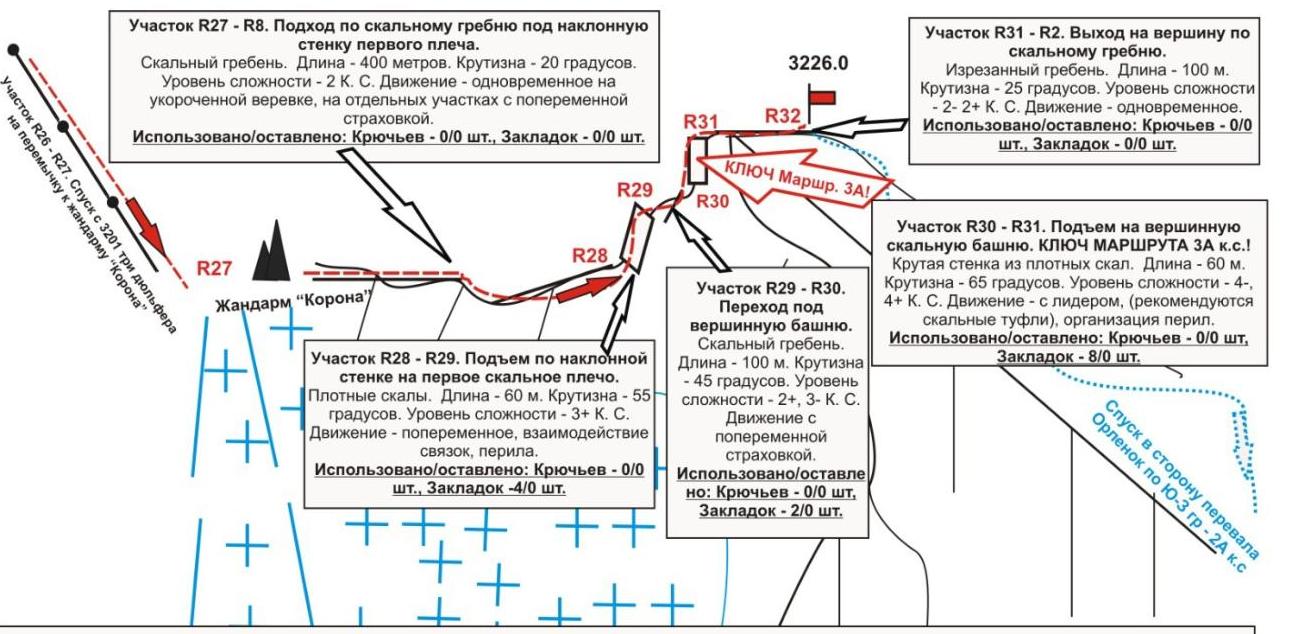
Further — traverse along an osypnaya polka, a small ascent to the gendarme "Korona" and the beginning of the technical part of the route 3A category of difficulty.
The third section of the traverse (route 3A category of difficulty). From the gendarme "Korona", movement does not cause difficulty in orientation, as it goes strictly along the line of the ridge (to the right along the way). Further, a logical ascent follows along the northern ridge to the peak 3226 m (Taulan, «Dimitrov–100»). At first along simple, then along rocks of medium complexity, ascend under an inclined wall. The wall is overcome "en face" and leads to a rock shoulder. Along simple rocks, approach under the summit tower.
The key point of the route 3A category of difficulty is the ascent to the summit tower. A steep wall. Rocks of increased complexity, but with an abundance of relief, allowing organizing intermediate belay points with the help of pitons, chocks. The most convenient:
- among pitons — shвеллера,
- among chocks — friends.
Rockfall hazard is subjective. In the off-season, there may be nached ice on the rocks. After passing the key wall — exit to a simple rock ridge, flattening towards the peak. On the peak 3226, the traverse is completed.
Descent from the Peak
The descent from the peak is made along the route 2A category of difficulty along the south-western ridge.
Western Caucasus. Arkhyz. Orlenok gully.
Peaks:
- 2900 (Kara-Jash NE)
- Kara-Jash (3171)
- 3170
- 3201 (BDS)
- 3226 («Dimitrov-100»)
Route: "Traverse of peaks 2900 (Kara-Jash NE) — Kara-Jash (3171) — 3170 — 3201 (NRB)"
Level of difficulty — 4A category of difficulty (combined)
Scheme in UIAA symbols of the traverse section from the gendarme "Korona" to the peak 3226 (Taulan, «Dimitrov-100»).
Western Caucasus. Arkhyz. Gnilaya gully.
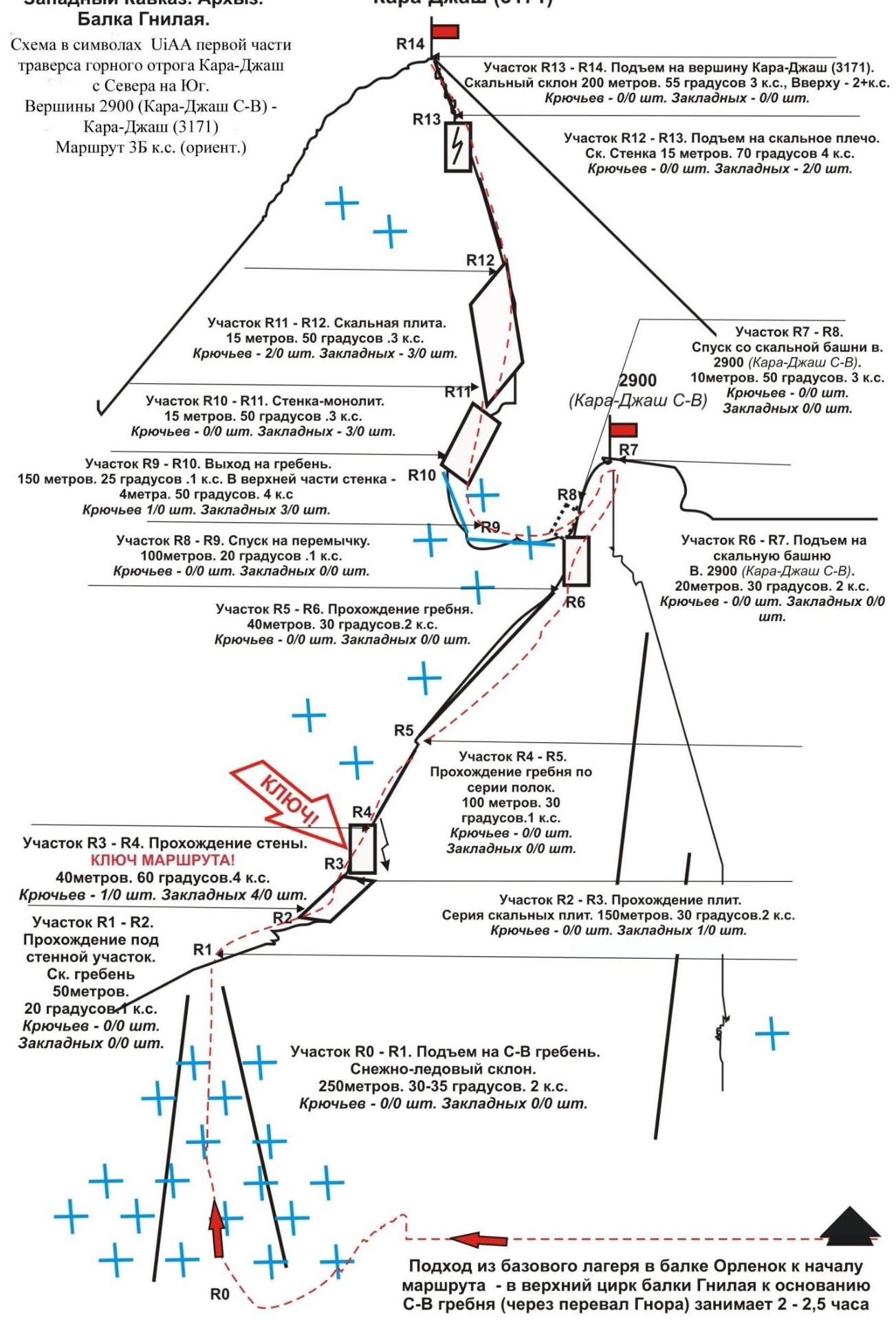
Table of Natural Obstacles on the Route
Route: Traverse of peaks:
- 2900 (Kara-Jash North-East)
- Kara-Jash (3171)
- 3170
- 3201 (NRB)
- 3226 (Taulan, «Dimitrov-100») from north-east to south.
Level of difficulty: I 4 (Combined) (approximately). (table of natural obstacles on the route — appendix to the scheme in UIAA symbols)
| section | Length | Steepness | Character of relief | Category of difficulty | Number of pitons, chocks |
|---|---|---|---|---|---|
| R0 — start of the route, cirque of Gnilaya gully. | Convenient place for organizing links. | ||||
| R0–R1 Ascent to the saddle (per. Lipetsky). | 250 | 30-35 | Snow, in summer — firn | 2- | Rock pitons — 0/0, Chocks — 0/0 |
| R1–R2 Approach under the wall along the rock ridge | 50 | 20 | Disintegrated rock ridge | 1 | Rock pitons — 0/0, Chocks — 0/0 |
| R2–R3 Ascent along rock slabs. | 150 | 30-35 | Rock slabs | 2 | Rock pitons — 1/0 Chocks — 0/0 |
| R3–R4 Passage through a destroyed rock wall. | 40 | 60 | Steep, strongly destroyed rocks. Subjective rockfall hazard! | 4- | Rock pitons — 0/0 Chocks — 3/0 Convenient place for belay |
| R4–R5 Ascent along a rock ridge under a rock tower | 100 | 30 | Rock ridge | 1+ | Rock pitons — 0/0 Chocks — 0/0 |
| R5–R6 Ascent along a rock ridge to the summit tower 2900 (Kara-Jash North-East) | 40 | 30 | Rock ridge | 2+ | Rock pitons — 0/0 Chocks — 0/0 |
| R6–R7 Ascent to the peak 2900 (Kara-Jash North-East) | 20 | 35 | Inclined rock slab-monolith | 2+ | Rock pitons — 0/0 Chocks — 0/0 |
| R7 — peak 2900 m (Kara-Jash North-East) | Control point! | ||||
| R7–R8 Descent along destroyed rocks to the saddle | 10 | 50 | Strongly destroyed rock slope | 3 | Rock pitons — 0/0 Chocks — 0/0 |
| R8–R9 Passage along a snowy-icy ridge to the saddle. | 100 | 20 | Snowy-icy slope. | 1 | Rock pitons — 0/0 Chocks — 0/0 |
| R9–R10 | 150 | 25 | Rock | 1 | Rock pitons — 0/0 |
| Approach under the summit tower v. Kara-Jash (3171) | 5 | 50 | Ridge, slabs, inclined polki | 4- | Chocks — 3/0 |
| :--: | :--: | :--: | :--: | :--: | :--: |
| R10–R11 Passage of a rock wall v. Kara-Jash (3171) | 15 | 50 | Wall — monolith | 3 | Rock pitons — 0/0 Chocks — 3/0 |
| R11–R12 Passage of a slab | 15 | 50 | Inclined slab | 3 | Rock pitons — 0/0 Chocks — 1/0 |
| R12–R13 Passage of a wall with a crack and exit to the pre-summit ridge | 15 | 70 | Wall with a crack | 4 | Rock pitons — 0/0 Chocks — 2/0 |
| R13–R14 Passage of the pre-summit ridge and exit to the peak | 200 | 55 | Rock ridge | 2+ | Rock pitons — 0/0 Chocks — 3/0 |
| R14 — peak Kara-Jash (3171) | Well expressed. Tur is easily found. | ||||
| R14–R15 Movement along the southern ridge v. Kara-Jash | 45 | 20 | Rock ridge | 2 | Rock pitons — 0/0 Chocks — 0/0 |
| R15–R16 Descent from the southern rock shoulder | 15 | 50 | Rappelling with pulling | 3 | Rock pitons — 0/0 Chocks — 0/0 |
| R16–R17 Passage along the southern ridge | 35 | 20 | Rock ridge | 2 | Rock pitons — 0/0 Chocks — 0/0 |
| R17–R18 Descent to the saddle under the rock tower v. 3170. | 15 | 50 | Rappelling with pulling | 3 | Rock pitons — 0/0 Chocks — 0/0 |
| R18–R19 Exit to the peak 3170 (19th Congress of the Komsomol) | 60 | 30 | Polka, rock ridge | 2+ | Rock pitons — 0/0 Chocks — 2/0 |
| R19 peak 3170 | Control point! | ||||
| R19–R20 Movement along the southern ridge of peak 3170 | 10 | 30 | Rock ridge | 2+ | Rock pitons — 0/0 Chocks — 0/0 |
| R20–R21. Rappelling to the saddle under the gendarme "Bashnya" | 25 | 80 | Rappelling with pulling | 4+ | Rock pitons — 0/0 Chocks — 0/0 |
| R21–R22 Traverse of the southern wall along a wide polka | 100 | 20 | Destroyed rocks, snow. | 1 | Rock pitons — 0/0 Chocks — 0/0 |
| R22–R23 Ascent to the gendarme "Bashnya" | 30 | 70 | Steep rock wall. On the gendarme, a control point! | 4+ | Rock pitons — 0/0 Chocks — 5/0 |
| R23–R24 | 30 | 20 | At first | 2+ | Rock pitons — 0/0 |
| Rappelling to the saddle under the peak 3201 (BDS) | To the right along the polka, then down. | Chocks — 2/0 | |||
| :--: | :--: | :--: | :--: | :--: | :--: |
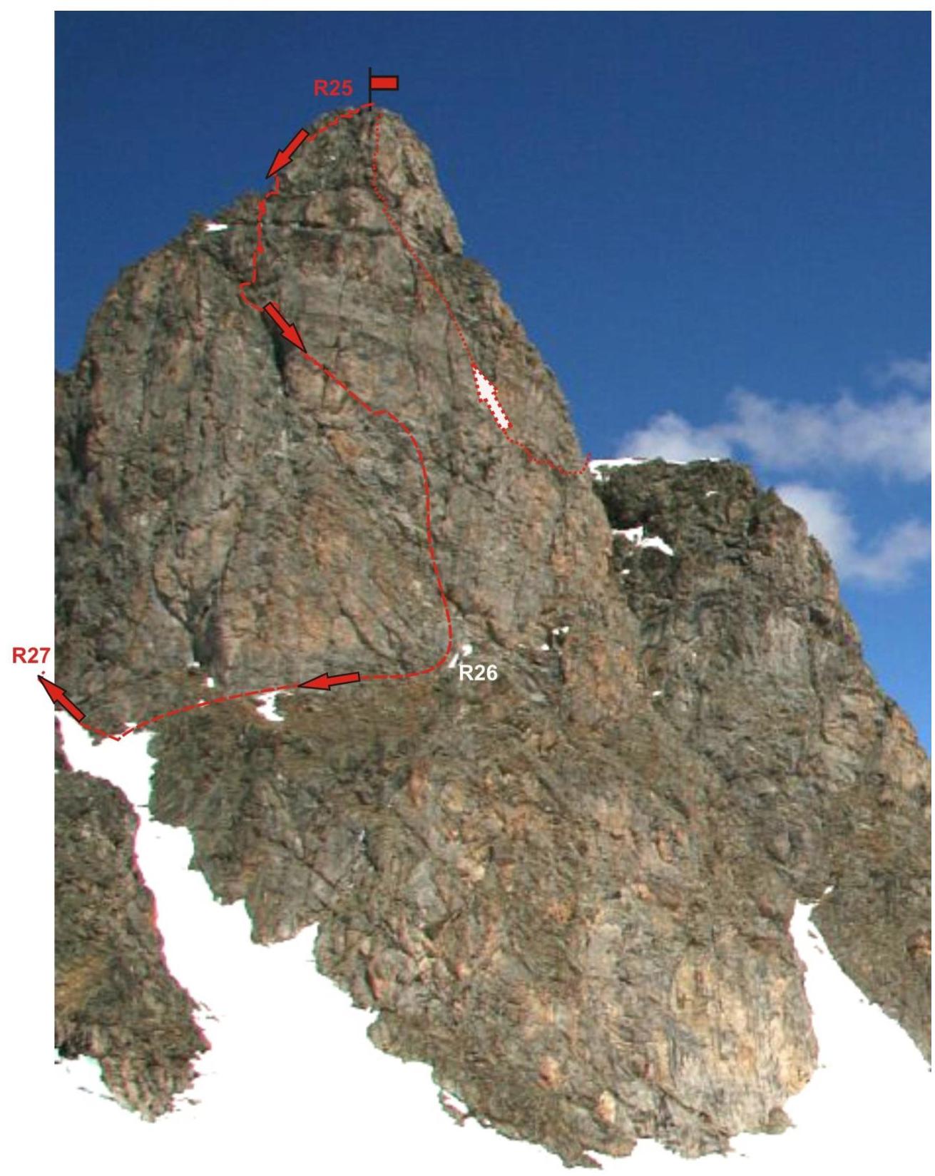
| R24–R25 Ascent to the peak 3201 (NRB) along the northern ridge | 25 | 60 | Internal angle, destroyed ridge | 3- | Rock pitons — 0/0 Chocks — 2/0 |
| R25 — peak 3201 (NRB) | Well expressed. Control point! | ||||
| R25–R26 Three rappels of 50 m along the south-east wall. Stationary loops, constant stations (descent from the route 4A category of difficulty) | 150 | 70 | Wall | 4-, 4+ | Rock pitons — 0/0 Chocks — 0/0 |
| R26–R27 Exit to the saddle to the gendarme "Korona" | 50 20 | 15 25 | Osypnaya polka. Snowy couloir | 2- 1 | Rock pitons — 0/0 Chocks — 0/0 |
| R27–R28 Ascent along the northern ridge to 3226 (Taulan, Dimitrov-100) | 400 | 20 | Ridge, destroyed rocks | 2 | Rock pitons — 0/0 Chocks — 0/0 |
| R28–R29 Passage of an inclined slab and exit to the first rock shoulder of the southern ridge of v. 3226. | 60 | 55 | Rock slab | 3+ | Rock pitons — 0/0 Chocks — 3/0 |
| R29–R30 Passage along the ridge under the summit tower | 100 | 45 | Destroyed rock ridge | 2+ | Rock pitons — 0/0 Chocks — 4/0 |
| R30–R31 Passage of a rock wall on the summit tower (Key point of the route 3A!) | 60 | 65 | Wall, rock monolith | 4-(20 m) 3+(40 m) | Rock pitons — 2/0 Chocks — 8/0 |
| R31–R32 Ascent to the peak along the pre-summit ridge | 100 | 25 | Jagged ridge | 2 | 0/0 |
| R32 — peak 3226 (Taulan, «Dimitrov-100») | The peak is well expressed, the tur is easily found. | ||||
| DESCENT | Along the route 2A category of difficulty along the south-western ridge. |
Total:
Length of the route — 2480 m. Average steepness — 55°. Character of relief — combined.
Technically complex sections:
1 category of difficulty — 6 sections — 520 m, 2 category of difficulty — 14 sections — 1490 m, 3 category of difficulty — 8 sections — 185 m, 4 category of difficulty — 7 sections — 285 m, 5 category of difficulty — 0 sections — 0 m, 6 category of difficulty — 0 sections — 0 m
Number of pitons used/left — 5/0 pcs, chocks — 30/0 pcs.
Internal angle when exiting to the peak 3201
(NRB)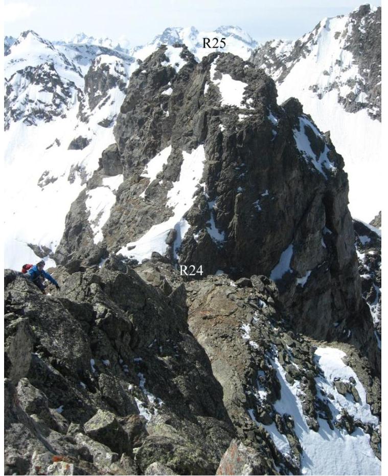
Western Caucasus. Arkhyz. Orlenok gully. Peak — 3226 («Dimitrov-100»). Route:
"Traverse 2900–3226 from north-east to south"; 4A category of difficulty (combined) Section
R25–R27 — descent from the peak 3201 (NRB) and exit to the saddle to the gendarme
"Korona"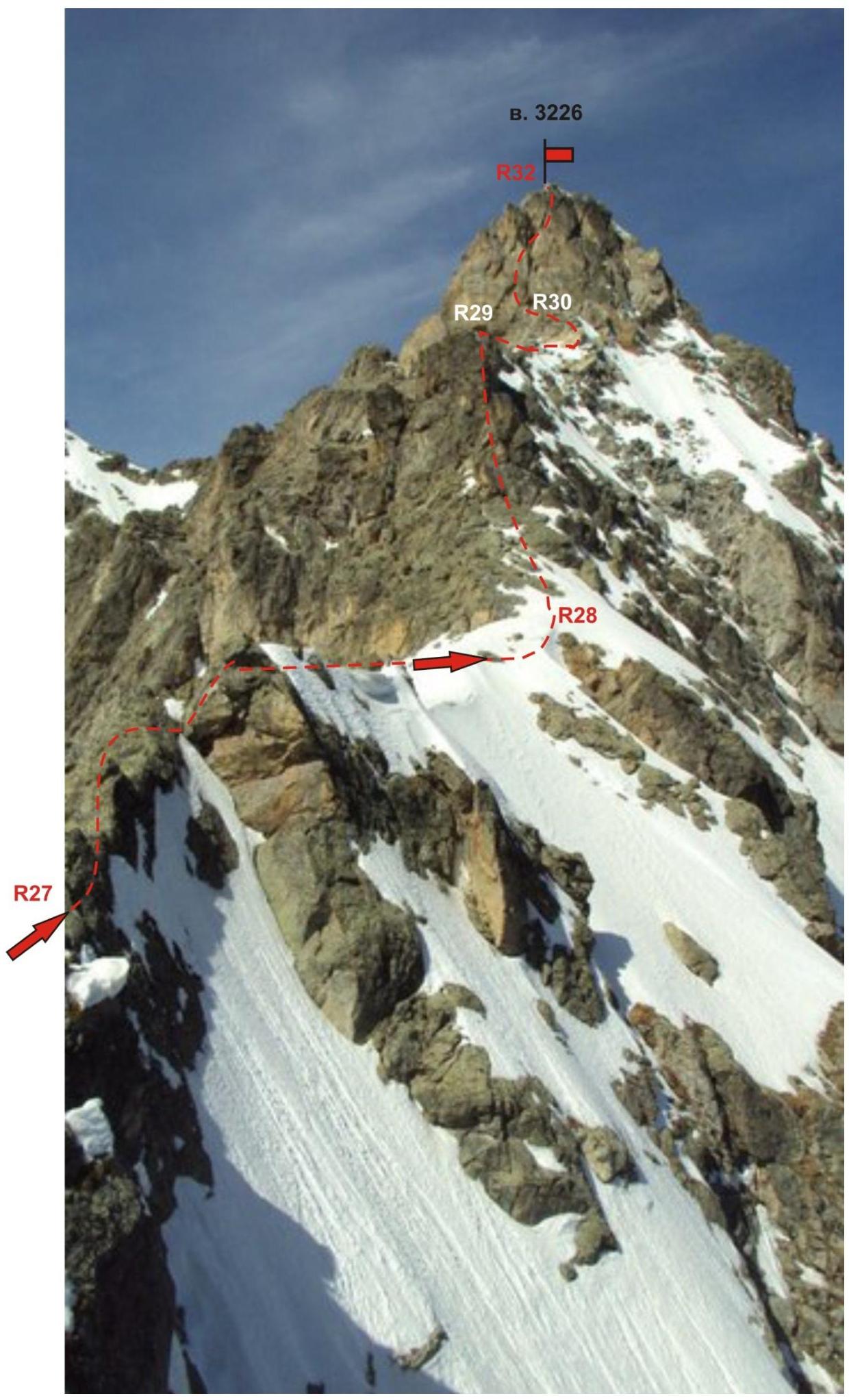
R27 Section R19–R20. Upper part of the ridge when exiting to the peak
3170
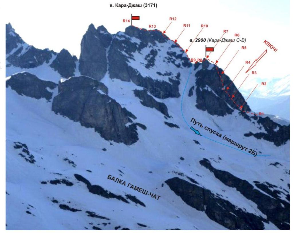
Western Caucasus. Arkhyz. Gamesh-Chat gully. Mountain spur Kara-Jash. Route: Traverse from North to South of peaks:
- 2900
- Kara-Jash C–B) Kara-Jash — 3170 — 3201
- (PRB) — 3226 («Dimitrov-100»).
4A category of difficulty (combined) first section of the traverse v. 2900 — Kara-Jash (3171) (route 3B category of difficulty (approximately)).
Photo of the route from Gamesh-Chat gully. R0 — start of the route in Ginzako gully. Not visible on the photo.
Red dashed line — path of the group of climbers. Solid line — possible descent along the eastern couloir from the peak Kara-Jash along the route 2B category of difficulty.
Comments
Sign in to leave a comment