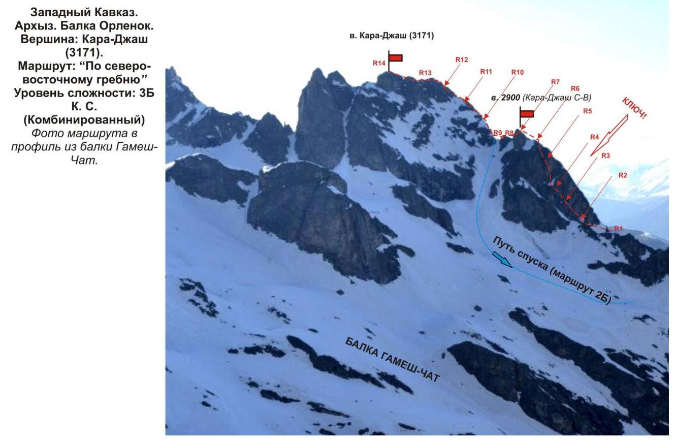
Kara-Djash peak (3171 m). Route: via the north-eastern ridge. Category of difficulty: 3B cat. diff. (combined). Leader: K. Shustov. Western Caucasus, Arkhyz, Orlenok gully, Kara-Djash mountain range.
Section in KMGV — 2.1. E-mail — ZHUR58@RAMBLER.RU
Report
On the first ascent of the alpinist route to the Kara-Djash peak (3171 m) "via the north-eastern ridge (combined)". At the year-round alpine event, competition in mountaineering NP "Club of Northern Travels "Sauk-Pai" 2013 — "Cup of Victory" (class "First Ascents").
Region: Karachay-Cherkess Republic. Mountain range: Western Caucasus. Gully: Orlenok. Mountain range: Kara-Djash. Peak: Kara-Djash (3171). Route: via the north-eastern ridge. Level of difficulty: 3B cat. diff. (combined). Prepared by: K. Shustov, S. Zhuravlev. May, 2013.
Description of the peak
Kara-Djash peak (3171) is a nodal peak of the Kara-Djash mountain range. Located on the territory of the Caucasian Federal District of the Russian Federation, in the Karachay-Cherkess Republic, Arkhyz mountain region (Orlenok gully), between the rivers:
- Psyish
- Sofia
- Orlenok
Kara-Djash peak (3171 m) is a pronounced mountain of the Kara-Djash range, easily identifiable from the Taulu meadow, located at the confluence of the Sofia river into the Psyish river. The name of the peak is official, marked on the geographical maps of the Russian Federation (Scale: 1 cm — 1 km), and translates from the Karachay language as "Black Prince".
Description of the route
The route "Via the north-eastern ridge" is an orographically logical and technically interesting combined sports route of category 3B. The key to the route is a rock section of increased complexity.
Equipment
To complete the ascent as part of a sports team of 4 people, the following special equipment is required on the route:
- Personal — standard, crampons, and ice axe for approaches
- Team:
- Main rope 10 mm — 2×60 m
- Rock hammer — 2 pcs.
- Rock pitons — 16 pcs.
- Ice axe — 1 pc.
- Nuts — 12 pcs.
- Friends — 6 pcs.
- Ice screws — 0 pcs.
- Quickdraws — 16 pcs.
- Slings — 10 pcs.
For the leader, rock shoes are necessary!
Approach
The ascent is made from a bivouac in the upper cirque of the Orlenok gully. The approach to the bivouac is not complicated: from the Taulu meadow, cross the Sofia river by bridge and ascend the Orlenok gully — first along a logging road, then along a clearly visible trail.
The cirque is pronounced: in winter and spring — snowy, in summer — overgrown with high-altitude vegetation with two beautiful lakes among small birch and pine groves.
From the Taulu meadow, the ascent to the cirque takes 1.5–2 hours. In the cirque, there are convenient places for tents, with water (streams) and dry areas, freed from snow at the end of April — beginning of May.
The height of the bivouac by the lake above sea level is 2200 m.
From the bivouac in the upper cirque, through the pass between the Orlenok peak and the north-western ridge of Kara-Djash peak (Gnora pass), move to the upper cirque of the Gnilaya gully.
The route begins from the upper cirque of the Gnilaya gully. In the panorama of the cirque, Kara-Djash peak is the dominant and easily identifiable peak.
The approach from the bivouac to the start of the route — the rocky block "Orekh" — takes about an hour.
Technical part
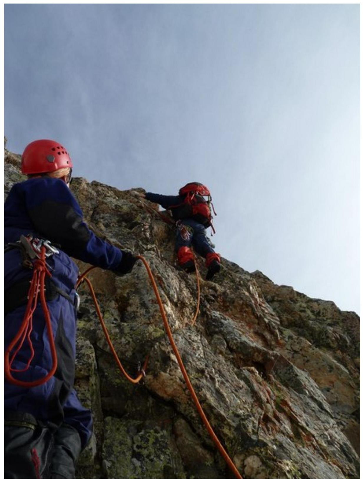
The route begins with an ascent up a snowy slope to the north-eastern ridge. Along the ridge, approach the rock wall. This is the key location of the route.
The key to the route is a very complex, steep rock wall, strongly dissected. Subjectively, it is rockfall-prone!
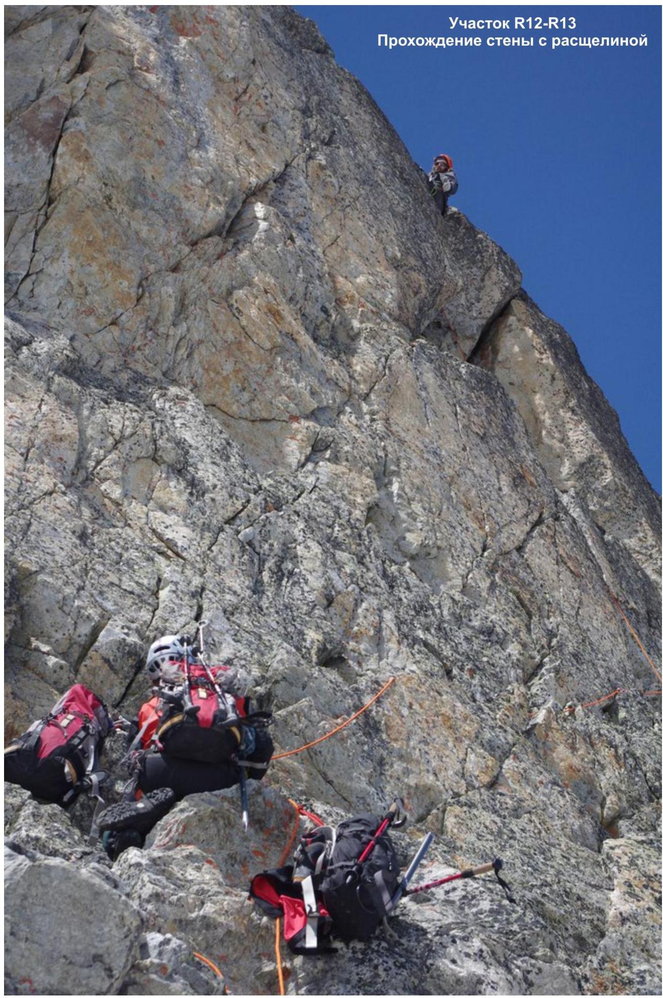
After passing the key section, ascend along the pronounced rocky ridge to the 2900 m peak (Kara-Djash North-Eastern). From the 2900 m peak, descend to the ridge and along the snowy-icy ridge, reach the saddle. From the saddle, along inclined slabs and ridge sections, approach the summit tower of Kara-Djash peak. Ascend the summit tower via a wall with a crack. The wall is complex, but there is sufficient relief for organizing intermediate belay points. Further, along the pre-summit ridge, exit to the Kara-Djash peak.
The summit is a rocky pyramid-shaped, well-defined peak. The cairn is easy to find.
Descent from the summit
The descent from the summit is made via the route of category 2B — first along the northern ridge to the saddle, separating the Kara-Djash and Kara-Djash (North-Eastern) peaks. Then, down the eastern couloir into the Gamesh-Chat river valley.
Further:
- along the trail along the river, descend into the Sofia river valley,
- cross the river by a log bridge,
- descend along a dirt road to the Taulu meadow.
To return to the Orlenok gully, it is possible to cross:
- through the north-eastern ridge into the Gnilaya gully,
- then through the north-western ridge (Gnora pass) into the Orlenok gully.
Passport
- Section number according to KMGV — 2010 — 2.1.
Western Caucasus, mountain region — Arkhyz, Orlenok gully, Kara-Djash mountain range.
- Name of the peak: Kara-Djash
- Height: 3171
- Route: via the north-eastern ridge
- Category of difficulty: 3B
- Character of the route — combined
- Height difference of the route: 970 m
- Length of the route: 1160 m
- Length of sections of the highest category of difficulty:
Sections:
- 1 cat. diff. — 4 sections — 400 m
- 2 cat. diff. — 5 sections — 660 m
- 3 cat. diff. — 3 sections — 40 m
- 4 cat. diff. — 3 sections — 60 m
- 5 cat. diff. — 0 sections — 0 m
- 6 cat. diff. — 0 sections — 0 m
- Steepness of the route — 60°.
- Pitons used:
Used in total on the route:
- rock pitons — 1
- nuts — 15
- bolt pitons stationary — 0
- ITO — A4 — 5 points
- bolt pitons removable — 0
Left "pitons" on the route: total — 4; including bolt pitons — 0, nuts — 0.
- Exit to the route — 4:00, May 6, 2013.
Reached the summit — 12:00, May 6, 2013. Returned to BL — 14:30, May 6, 2013.
- Team's walking hours: — 11 hours.
- Leader: K. Shustov (CMS, instructor-methodologist 3 category, Ufa).
Participants:
- P. Isupov (3rd sports category, Kazan)
- I. Yugov (2nd sports category, Ufa)
- K. Petrov (3rd sports category, Kazan)
- A. Mindubaev (3rd sports category, Kazan)
- Coach: K. Shustov, title — CMS, instructor-methodologist 3 category.
Note: The route is not included in the classifier, but a description of a similar route, classified as 3B, is available on internet resources. In this regard, following the ethics of first ascents, the group of alpinists led by K. Shustov requests the classification commission of the FAR to consider and include this route in the KMGV without indicating the leader's surname and the year of the first ascent. Western Caucasus. Arkhyz. Gnilaya gully
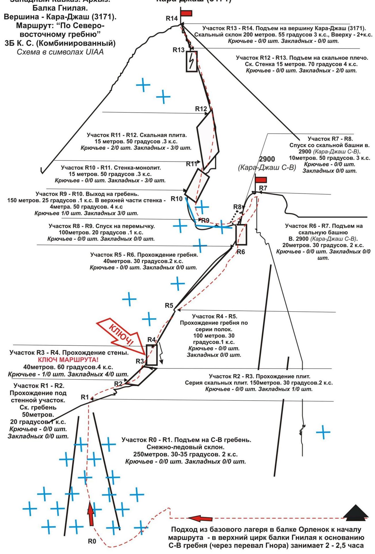 Western Caucasus, Arkhyz, Orlenok gully. Kara-Djash mountain range. Kara-Djash peak (3171 m). Route: "Via the north-eastern ridge". 3B (combined) (approximately). (table of natural obstacles of the route — appendix to the scheme in UIAA symbols)
| Section | Length | Steepness | Character of relief | Cat. diff. | Number of pitons, nuts |
|---|---|---|---|---|---|
| R0 — start of the route — cirque of Gnilaya gully. | Convenient place for organizing | ||||
| R0–R1 — ascent to the saddle (Lipetsky pass). | 250 | 30-35 | Snow, in summer — névé | 2- | Pitons — 0/0 Nuts — 0/0 |
| R1–R2 — approach under the wall along the rocky ridge | 50 | 20 | Destroyed rocky ridge | 1 | Pitons — 0/0 Nuts — 0/0 |
| R2–R3 Ascent along rocky slabs. | 150 | 30-35 | Rocky slabs | 2 | Pitons — 0/1 Nuts — 0/0 |
| R3–R4 Passage of the destroyed rocky wall. KEY SECTION OF THE ROUTE! | 40 | 60 | Steep, strongly destroyed rocks R. Subj. rockfall hazard! | 4- | Pitons — 0/0 Nuts — 3/0 Convenient place for belay |
| R4–R5 Ascent along the rocky ridge under the rocky tower | 100 | 30 | Rocky ridge | 1+ | Pitons — 0/0 Nuts — 0/0 |
| R5–R6 Ascent along the rocky ridge under the summit tower 2900 (Kara-Djash North-Eastern) | 40 | 30 | Rocky ridge | 2+ | Pitons — 0/0 Nuts — 0/0 |
| R6–R7 Ascent to the peak | 20 | 35 | Inclined rocky | 2+ | Pitons — 0/0 Nuts — 0/0 |
| 2900 (Kara-Djash North-Eastern) | slab — monolith | ||||
| :--: | :--: | :--: | :--: | :--: | :--: |
| R7 — summit 2900 (Kara-Djash North-Eastern) | Control cairn! | ||||
| R7–R8 Descent along destroyed rocks to the saddle | 10 | 50 | Strongly destroyed rocky slope | 3 | Pitons — 0/0 Nuts — 0/0 |
| R8–R9 Passage along the snowy-icy ridge to the saddle. | 100 | 20 | Snowy-icy slope. | 1 | Pitons — 0/0 Nuts — 0/0 |
| R9–R10 Approach under the summit tower of Kara-Djash peak (3171) | 150 5 | 25 50 | Rocky ridge, slabs, inclined ledges | 1 4 | Pitons — 0/0 Nuts — 0/3 |
| R10–R11 Passage of the rocky slab of the summit tower of Kara-Djash peak (3171) | 15 | 50 | Wall — monolith | 3 | Pitons — 0/0 Nuts — 0/3 |
| R11–R12 Passage of the slab | 15 | 50 | Inclined slab | 3 | Pitons — 0/0 Nuts — 0/1 |
| R12–R13 Passage of the wall with a crack and exit to the pre-summit ridge | 15 | 70 | Wall with a crack | 4 | Pitons — 0/0 Nuts — 0/2 |
| R13–R14 Passage of the pre-summit ridge and exit to the summit | 200 | 55 | Rocky ridge | 2+ | Pitons — 0/0 Nuts — 0/3 |
| R14 — summit Kara-Djash (3171) | Well-defined. Cairn easy to find. | ||||
| DESCENT | Along the southern ridge and eastern couloir — 2B cat. diff. |
Total:
Length of the route — 1160 m. Average steepness — 55°. Character of relief — combined.
Sections:
- 1 cat. diff. — 4 sections — 400 m
- 2 cat. diff. — 5 sections — 660 m
- 3 cat. diff. — 3 sections — 40 m
- 4 cat. diff. — 3 sections — 60 m
- 5 cat. diff. — 0 sections — 0 m
- 6 cat. diff. — 0 sections — 0 m
(Pitons used/left — 1/0 pcs, nuts — 15/0 pcs.)
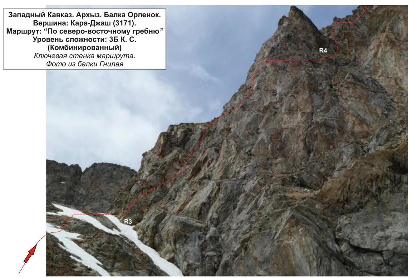
Western Caucasus. Arkhyz. Orlenok gully. Kara-Djash peak (3171). Route: "Via the north-eastern ridge". Level of difficulty: 3B cat. diff. (Combined)
Passage of the upper part of the key section:
- R3
- R4

2900 (Kara-Djash C–B)
R7 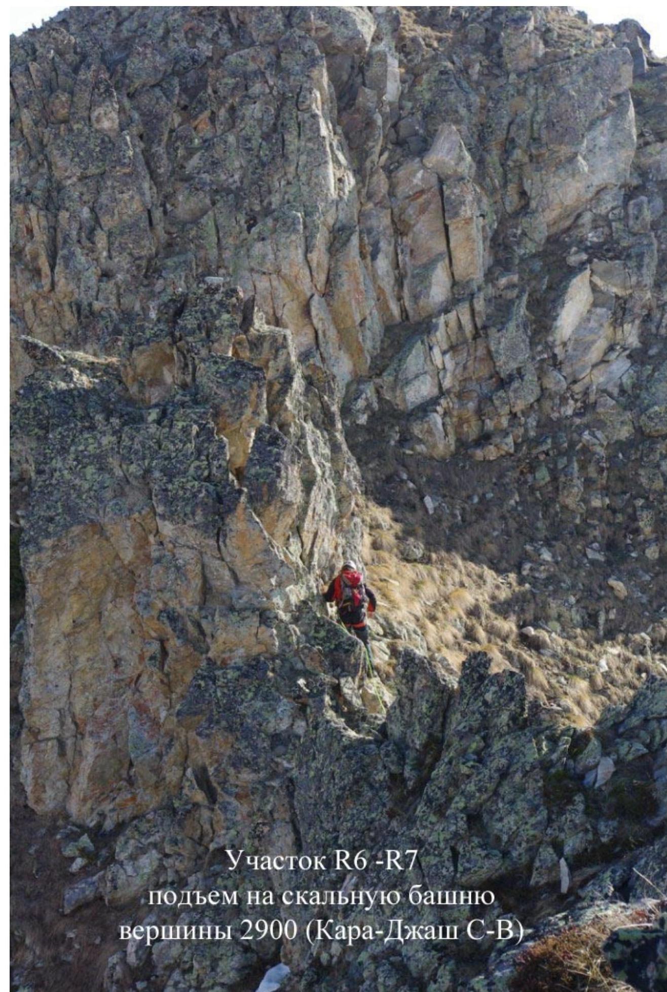
Section R6–R7 ascent to the rocky tower of the 2900 peak (Kara-Djash C–B)