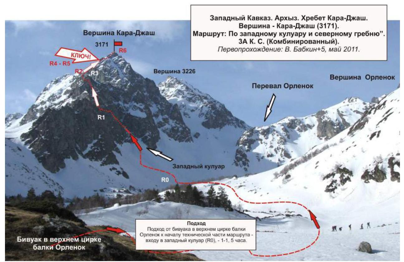
Kara-Djash Peak (3171)
Route: via the western couloir and northern ridge
Category of difficulty: 3A cat. sl. (Combined)
Leader: V. Babkin
Western Caucasus, Kara-Djash ridge
Section in CMGV - 2.1.
E-mail - ZHUR58@RAMBLER.RU
Report
On the first ascent of the mountaineering route to the top of Kara-Djash (3171) "Via the western couloir and northern ridge 3A cat. sl. (Combined)". At the year-round alpine event Championship and primacy of NP "Club of Northern Travels "Sauk-Pai" 2011 (class "First ascents").
Region: Karachay-Cherkess Republic Mountain country: Western Caucasus Gorge: Orlenok balk Ridge: Kara-Djash Peak: Kara-Djash (3171) Route: Via the western couloir and northern ridge
Prepared by: V. Babkin, Zhuravlev S. V. May, 2011
Passport
- Section number according to CMGV - 2010 - 2.1.
Western Caucasus, mountain region - Arkhyz, Kara-Djash ridge 2. Name of the peak: Kara-Djash Height: 3171 Route:
- via the western couloir
- via the northern ridge
- Category of difficulty: 3A cat. sl.
- Nature of the route - combined.
- Height difference of the route: 1171 m
- Length of the route: 2500 m
- Length of sections of the highest cat. sl.: 1 cat. sl. - 1 section - 150 m, 2 cat. sl. - 2 sections - 400 m, 3 cat. sl. - 3 sections - 420 m, 4 cat. sl. - 2 sections - 20 m, 5 cat. sl. - 0 sections - 0 m, 6 cat. sl. - 0 sections - 0 m.
- Average steepness: main part of the route - 60°, entire route - 45°.
9. Pitons used:
Used in total on the route:
- rock pitons - 6
- chocks - 18
- stationary pitons - 0
- ITO - 0
- removable pitons - 0
Left on the route: total - 0; including pitons - 0.
-
Departure on the route - 5:00, May 5, 2011 Arrival on the summit - 14:00, May 5, 2011 Return to BL - 18:00, May 5, 2011
-
Team's working hours: - 13 hours
-
First ascent (May 5, 2011)
Leader: Vyacheslav Babkin (CMS, instructor-methodologist 3rd category, Yekaterinburg).
Participants:
- O. Kolesnikova (2nd sports category, Syktyvkar)
- E. Ermakov (3rd sports category, Voronezh)
- A. Bonchuk (2nd sports category, Syktyvkar)
- I. Shcheglov (2nd sports category, Moscow).
Second ascent (May 7, 2011) Leader: Sergey Bernatsky (MS, instructor-methodologist 2nd category, Yekaterinburg).
Participants:
- S. Nikolaeva (3rd sports category, Voronezh)
- E. Burtsev (3rd sports category, Syktyvkar)
- S. Porotikov (3rd sports category, Syktyvkar)
- O. Ermolin (2nd sports category, Syktyvkar)
- G. Smetanina (3rd sports category, Yoshkar-Ola).
- Coach: Zhuravlev Sergey Vasilyevich, rank - CMS, instructor-methodologist 1st category.
Description of the peak
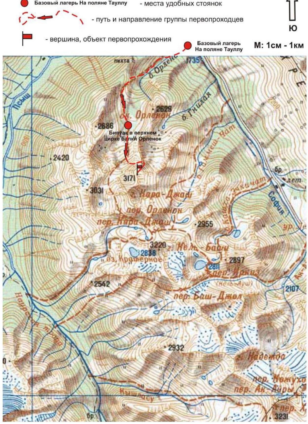
Kara-Djash peak (3171 m) is a nodal peak of the Kara-Djash ridge. Located on the territory of the Caucasus Federal District of the Russian Federation, in the Karachay-Cherkess Republic, Arkhyz mountain region, between the Psyish and Sofia rivers.
Kara-Djash peak (3171 m) is a pronounced mountain of the Kara-Djash ridge, easily identifiable from the Taullu glade, located at the confluence of the Sofia River into the Psyish River. The name of the peak is official, plotted on the geographical maps of the Russian Federation (Scale: 1 cm - 1 km), translated from the Karachay language - "Black Prince".
Description of the route
The route "Via the western couloir and northern ridge" is a characteristic training and educational combined route of 3A category of difficulty, with a full set of natural obstacles corresponding to routes of this level.
Passing this route has not only aesthetic but also practical training and sports significance, as it allows to work out insurance and self-insurance techniques on complex snow and rock terrain within the ascent.
Equipment
For the ascent as part of a training and sports group of 6 people (5 participants + instructor), the following special equipment is required on the route:
Personal:
- Standard issue
- Crampons
- Ice axe
Group:
- Main rope 10 mm - 3 × 50 m
- Rock hammer - 2 pcs.
- Rock pitons - 16 pcs.
- Ice axe - 1 pc.
- Chocks - 12 pcs.
- Ice screws - 0 pcs.
- Quickdraws - 10 pcs.
- Slings - 10 pcs.
Approach
The ascent is made from a bivouac in the upper cirque of the Orlenok balk. The approach to the bivouac in the upper cirque is not complicated in terms of orientation: from the Taullu glade, cross the Sofia River by a bridge and ascend along the Orlenok balk - first along a logging road, then along a clearly visible trail.
The cirque is pronounced, snowy in winter and spring off-season, overgrown with high-altitude vegetation in summer, with two beautiful lakes among small birch and pine groves. The height of the cirque above sea level is 2200 m. The ascent from the Taullu glade to the cirque takes 1.5-2 hours.
The cirque has convenient places for tents, with water (streams) and dry areas, freed from snow at the end of April, beginning of May.
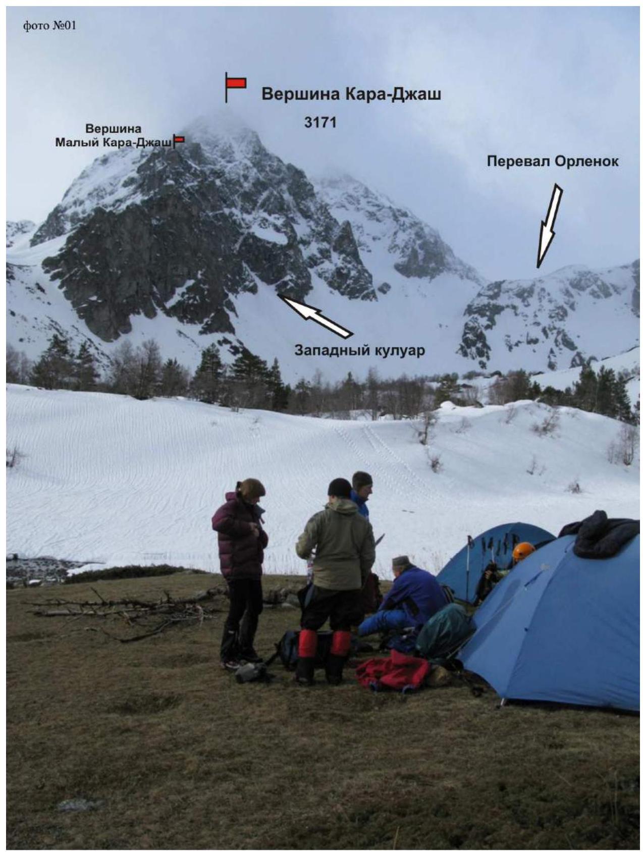
The panorama of the cirque includes:
- Kara-Djash peak, which is dominant and easily identifiable.
The approach from the campsite to the start of the route - the entrance to the couloir - takes about an hour. At the entrance to the couloir, it is necessary to organize rope teams, and in winter and off-season, wear crampons.
Technical part
The route begins with an ascent along a narrow steep couloir. Intermediate belay points can be conveniently organized in the rock walls of the couloir using chocks, pitons, and occasionally slings on outcrops.
Ascend the couloir to a saddle (in winter and off-season - a snowy cornice hanging to the west!!!), then along the ridge approach the base of the rocky summit tower.
The key to the route is a rocky wall with a cleft. It is passed by climbing.
When exiting onto the rocky tower of the summit, there are several rocky sections requiring participants to have the skills to organize proper belaying and self-belaying on rocky terrain.
- Subjective rockfall hazard.
- In the off-season, there may be formed ice on the rocks.
- The summit is peak-shaped, pronounced.
- There was no cairn or note on the summit.
It can be assumed that this ascent was not only the first ascent of the route but also the first ascent of the peak. The cairn was built by the first ascent team.
Descent from the summit
Descent from the summit is made along the ascent route. A simpler route was not found.
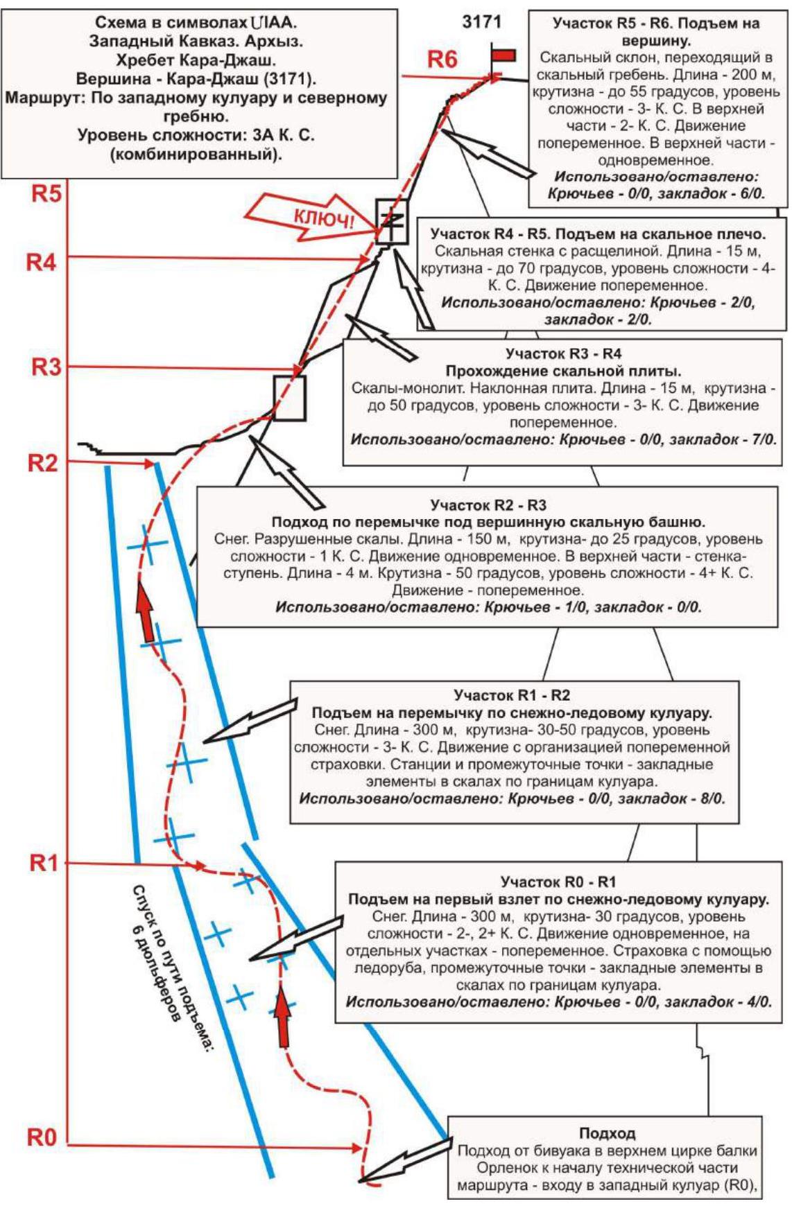
Section R5-R6. Ascent to the summit. Rocky slope turning into a rocky ridge.
- Length - 200 m
- Steepness - up to 55°
- Difficulty level - 3. In the upper part - 2
- Movement - alternating; in the upper part - simultaneous
- Used (left): pitons - 0/0, chocks - 6/0
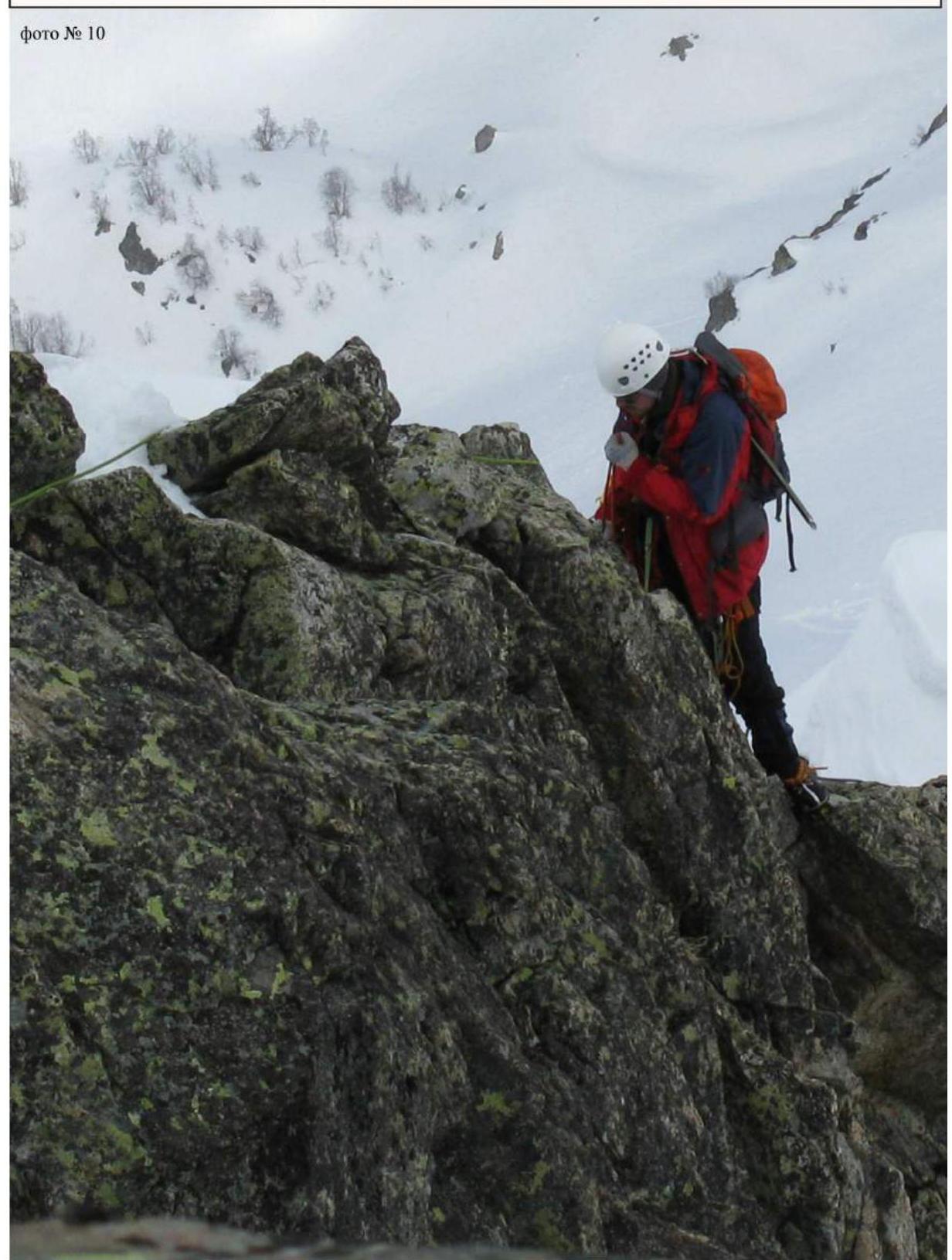
Section R4-R5. Ascent to a rocky shoulder. Rocky wall with a cleft.
- Length: 15 m
- Steepness: up to 70°
- Difficulty level: 4
Movement is alternating. Used (left):
- Pitons: 2/0
- Chocks: 2/0.
Section R3-R4. Passage of a rocky slab. Rock monolith. Inclined slab.
- Length: 15 m
- Steepness: up to 50°
- Difficulty level: 3
Movement is alternating. Used (left):
- Pitons: 0/0
- Chocks: 7/0.
Section R2-R3
Approach along the saddle to the summit rocky tower. Snow. Broken rocks.
- Length - 150 m
- Steepness - up to 25°
- Difficulty level - 1
- Movement - simultaneous
In the upper part - a wall-step.
- Length - 4 m
- Steepness - 50°
- Difficulty level - 4
- Movement - alternating
Used (left): pitons - 1/0, chocks - 0/0.
Section R1-R2
Ascent to the saddle along the snow-ice couloir. Snow.
- Length - 300 m
- Steepness - 30-50°
- Difficulty level - 3
Movement with organization of alternating belaying. Stations and intermediate points - chocks in rocks along the boundaries of the couloir.
Used (left):
- Pitons - 0/0
- Chocks - 8/0
Section R0-R1
Ascent to the first ascent along the snow-ice couloir. Snow. Length - 300 m, steepness - 30°, difficulty level - 2. Movement is simultaneous, in some areas - alternating. Belaying with an ice axe, intermediate points - chocks in rocks along the boundaries of the couloir.
Used (left):
- Pitons - 0/0
- Chocks - 4/0.
Approach from the bivouac in the upper cirque of the Orlyonok balk to the start of the technical part of the route - the entrance to the western couloir (R0).
Fragment of the map (Arkhyz) of the ascent area.
Additional conventional signs:
- Base camp on the Taullu glade
- places of convenient campsites
- path and direction of the first ascent team
- peak, object of the first ascent Base camp on the Taullu glade. Scale: 1 cm - 1 km.
Bivouac in the upper cirque of the Orlenok balk
Bivouac in the upper cirque of the Orlenok balk

Western Caucasus, Arkhyz, Kara-Djash ridge. Route: "Via the western couloir and northern ridge" 3A cat. sl. (combined). Section R3-R4.
Western Caucasus, Arkhyz, Kara-Djash ridge. Route: "Via the western couloir and northern ridge" 3A cat. sl. (Combined). Section R3-R4. Passage of a rocky slab. Length of the section - 15 m, steepness up to 50°, difficulty level - 3.
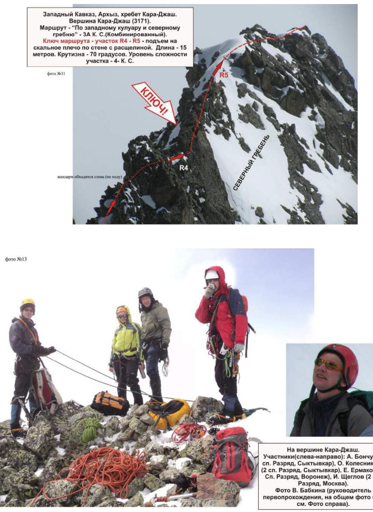
On the summit of Kara-Djash. Participants (from left to right):
- A. Bonchuk (2nd sports category, Syktyvkar)
- O. Kolesnikova (2nd sports category, Syktyvkar)
- E. Ermakov (3rd sports category, Voronezh)
- I. Shcheglov (2nd sports category, Moscow)
Photo by V. Babkin (leader of the first ascent, not in the group photo, see photo on the right).
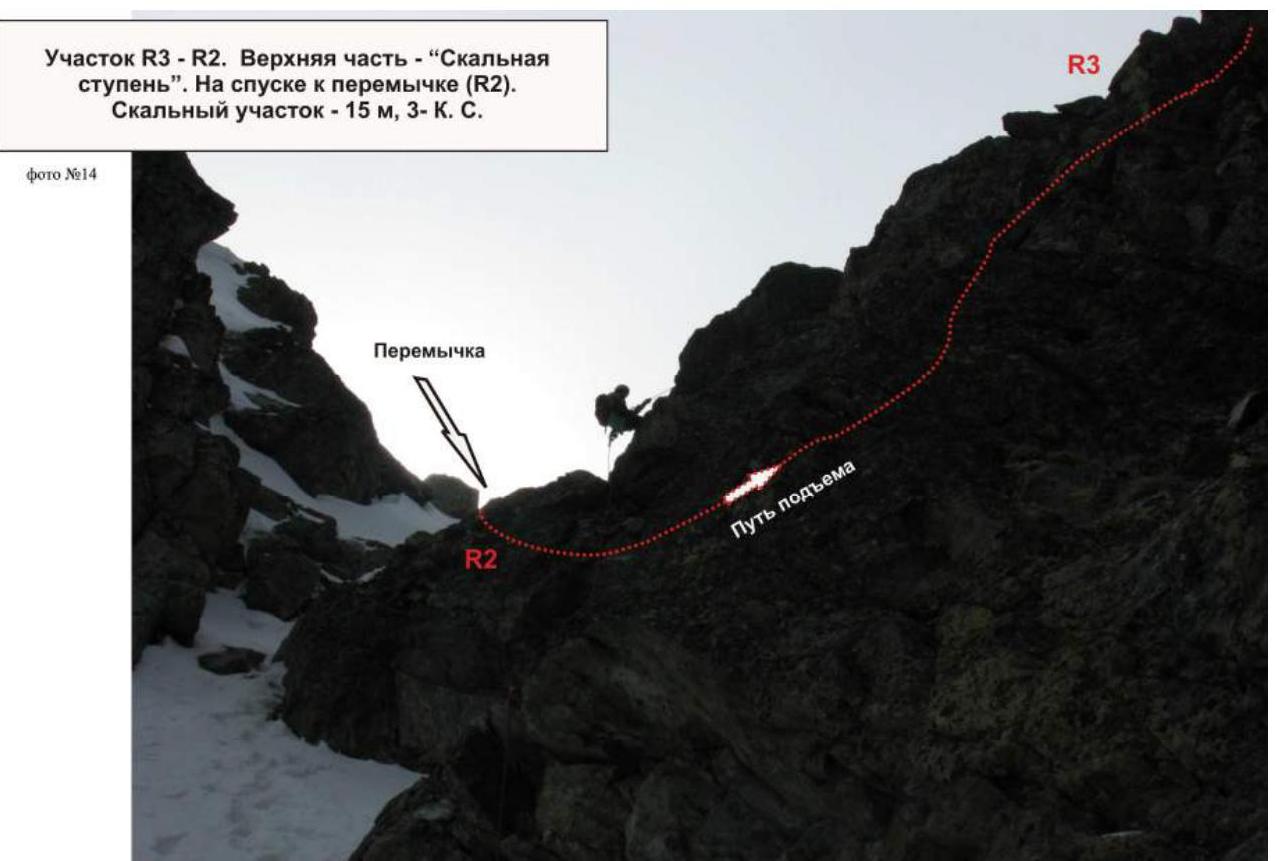
Section R3-R2. Upper part - "Rocky step". On descent to the saddle (R2).
- Rocky section - 15 m
- Difficulty level - 3
Kara-Djash ridge. Kara-Djash peak (3171). Route:
- Via the western couloir
- Northern ridge
Upper part of the route (photo by A. Bonchuk, from the southwest)
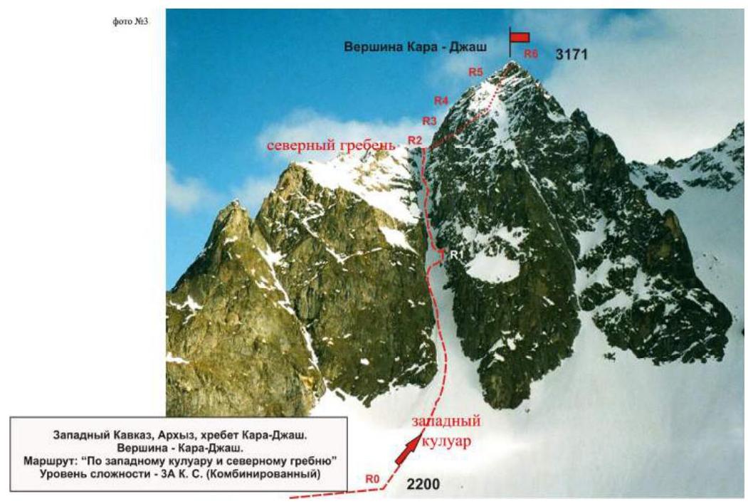
Western Caucasus, Arkhyz, Kara-Djash ridge. Kara-Djash peak. Route:
- Via the western couloir
- Northern ridge
Difficulty level - 3A cat. sl. (Combined)
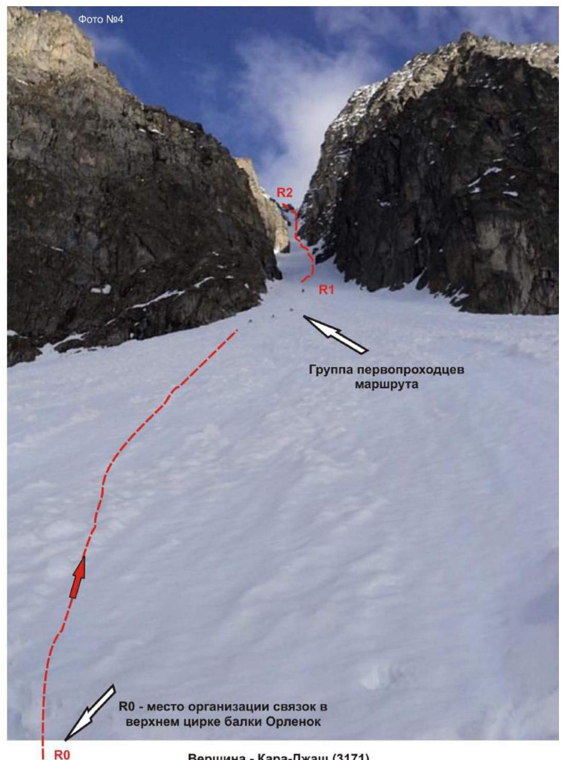
Kara-Djash peak (3171). Route: "Via the western couloir and northern ridge" 3A cat. sl. (Combined). Section: R0-R1-R2.
Ascent along the couloir.
Section R0-R1:
- Length - 300 m
- Steepness - 30°
- Difficulty level - 2
Section R1-R2:
- Length - 300 m
- Steepness - 45°
- Difficulty level - 2
Kara-Djash peak (3171). Route: Via the western couloir and northern ridge. Section: R0-R1. Ascent along the couloir. Length - 300 m. Steepness - 30°. Difficulty level - 2.

Western Caucasus, Arkhyz, Kara-Djash ridge. Route: "Via the western couloir and northern ridge" 3A cat. sl. (Combined)
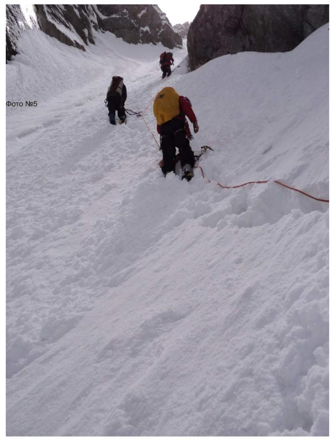
Section R1-R2
Passage of the upper part of the western couloir.
Steepness of the snow-ice slope - 55-70°.
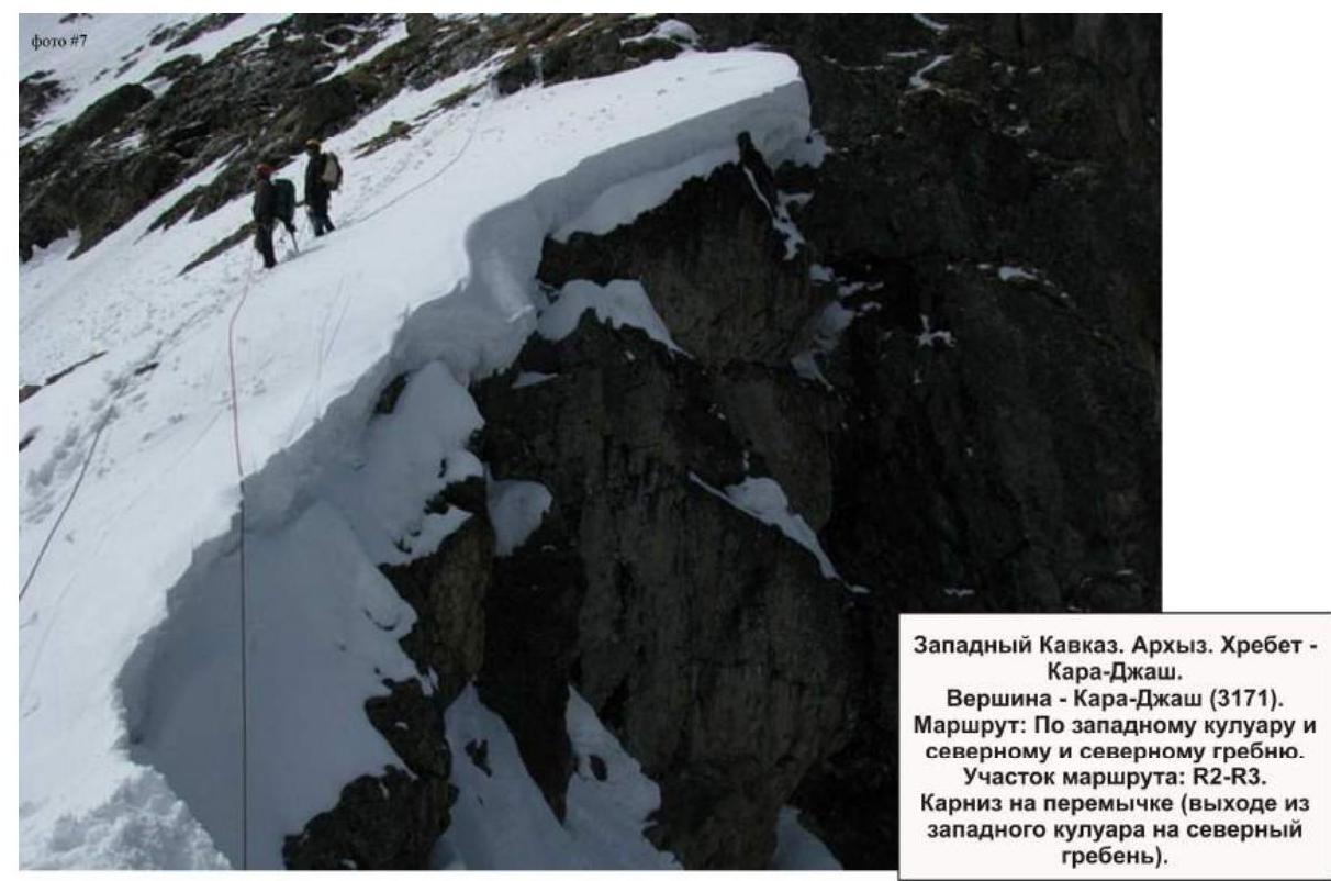
Western Caucasus. Arkhyz. Kara-Djash ridge. Kara-Djash peak (3171 m). Route: "Via the western couloir and northern ridge".
Section of the route: R2-R3.
- Cornice on the saddle (exiting from the western couloir onto the northern ridge).
Western Caucasus. Arkhyz. Kara-Djash ridge. Kara-Djash peak (3171 m). Route: Via the western couloir and northern ridge. Sections of the route: R2-R3, R3-R4 - exit onto the northern ridge and approach to the key section.
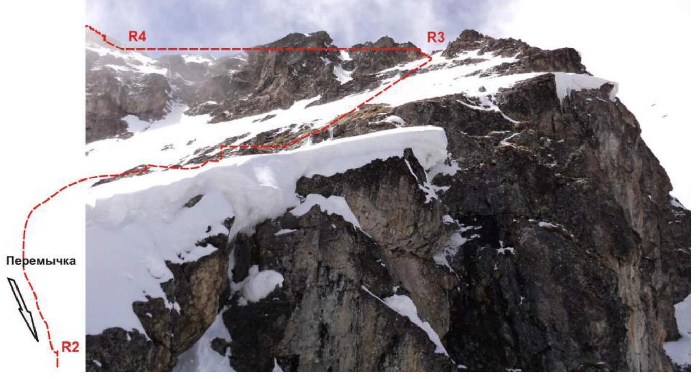
Western Caucasus. Arkhyz. Kara-Djash ridge. Kara-Djash peak (3171 m). Route: Via the western couloir and northern ridge. On the section of the route: R2-R3. Ascent from the saddle along the northern ridge.
