
Climbing Passport
- Climbing category: rock climbing.
- Climbing area: Arkhyz, Stavropol Krai, from the Kardyvach mountain area to Marukh pass.
- Peak, its height, and climbing route: Academician Kolesnik peak, 354 via the South wall
- Estimated category of difficulty: 2A.
- Route description:
Height difference — 400 m.
Average steepness — 40°.
Route length
| C.T.D. | 1 | 2 | 3 | 4 | 5 | 6 |
|---|---|---|---|---|---|---|
| M | 350 | 150 | 150 | - | - | - |
- Number of pitons:
| Rock | for belay | for created I.T.O. |
|---|---|---|
| 8 | no | |
| Ice | no | no |
| Bolt | no | no |
- Number of climbing hours: 14 hours
- Number of overnight stays and their description: none
- Surname, name, patronymic of the leader and participants, their sports qualification:
Shalobay Valentin Petrovich — Master of Sports Seleznev Viktor Nikolaevich — Candidate for Master of Sports Bobylyov Vladimir Dmitrievich — Candidate for Master of Sports Danilevsky Andrey Grigorievich — Candidate for Master of Sports Migunova Lina Vitalyevna — Candidate for Master of Sports
- Team coach: Gorda R. A.
- Date of departure and return: September 21, 1978.
DESCRIPTION
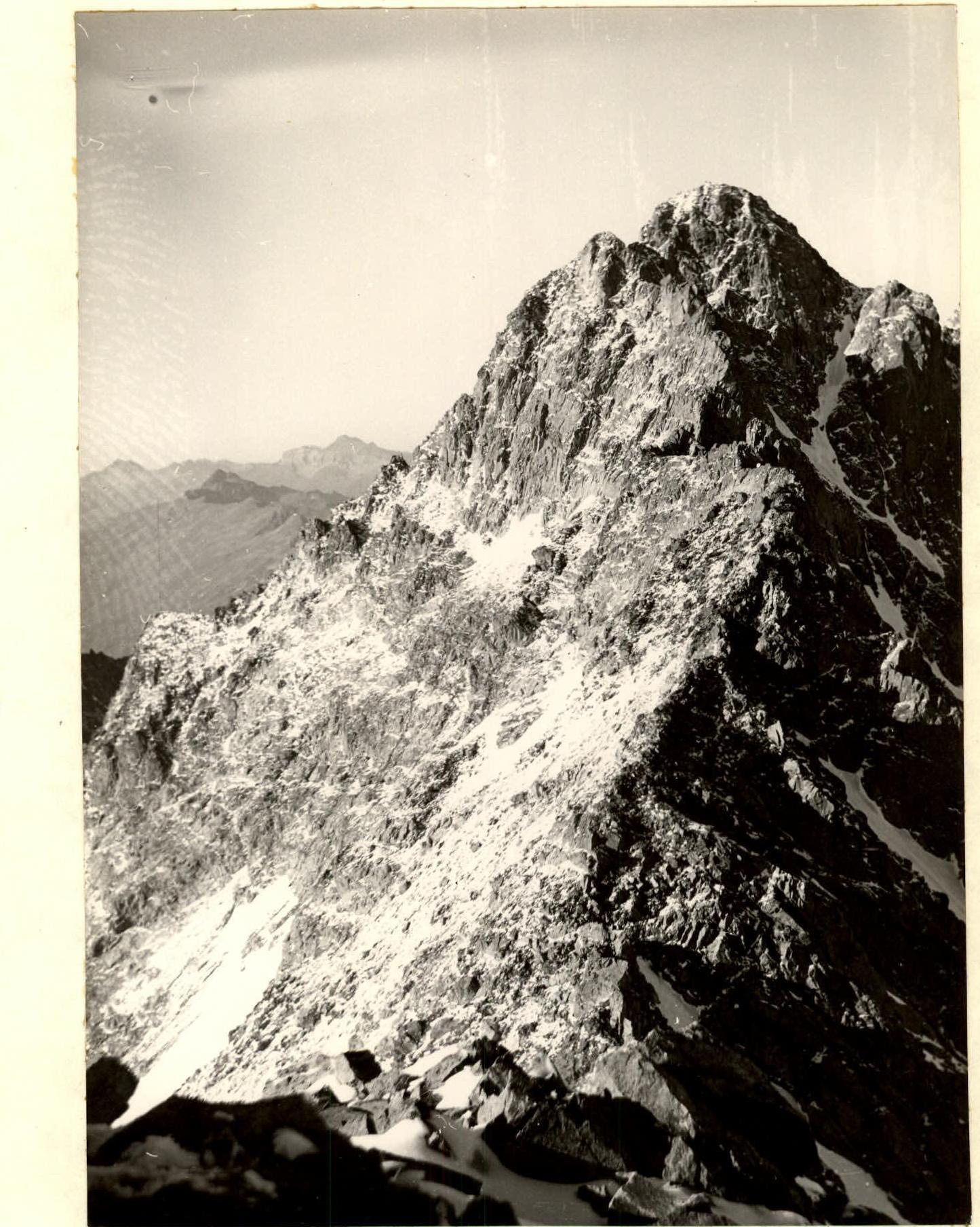
First ascent of Academician Kolesnik peak via the south wall, estimated category of difficulty 2A.
From the base camp located on the right (orographic) bank of the Amanauz river at the upper forest boundary — across a bridge over the river and then along the trail up the slope on the left (orographic) bank of the stream along the crest of the moraine ridge. Reaching the rocks, the trail goes around them on the left along a steep slope above the stream. Higher — a zone of tall grass. The steepness decreases, and the trail leads into a green cirque. Further ascent — along the dried-up stream bed in the southwest part of the cirque. A staircase of boulders leads to a stony pocket with a snowfield and a small lake. To the left, a disappearing trail along a steep ridge leads to an observation platform on the ridge (2650 m). Descent from the ridge to the tongue of the glacier. There are convenient bivouac sites near the tongue of the glacier.
The ascent to Amanauz pass begins on open ice, cut by deep crevasses. Further — a 200-meter icefall, sandwiched between rock walls. It is easier to pass it on the right along the way under the rock wall. After the icefall — a snow-ice slope with a steepness of about 30°. Above the icefall — a firn plateau, which (1 hour) leads to the pass. The pass is a destroyed rock saddle between Azimba peak and Academician Kolesnik peak.
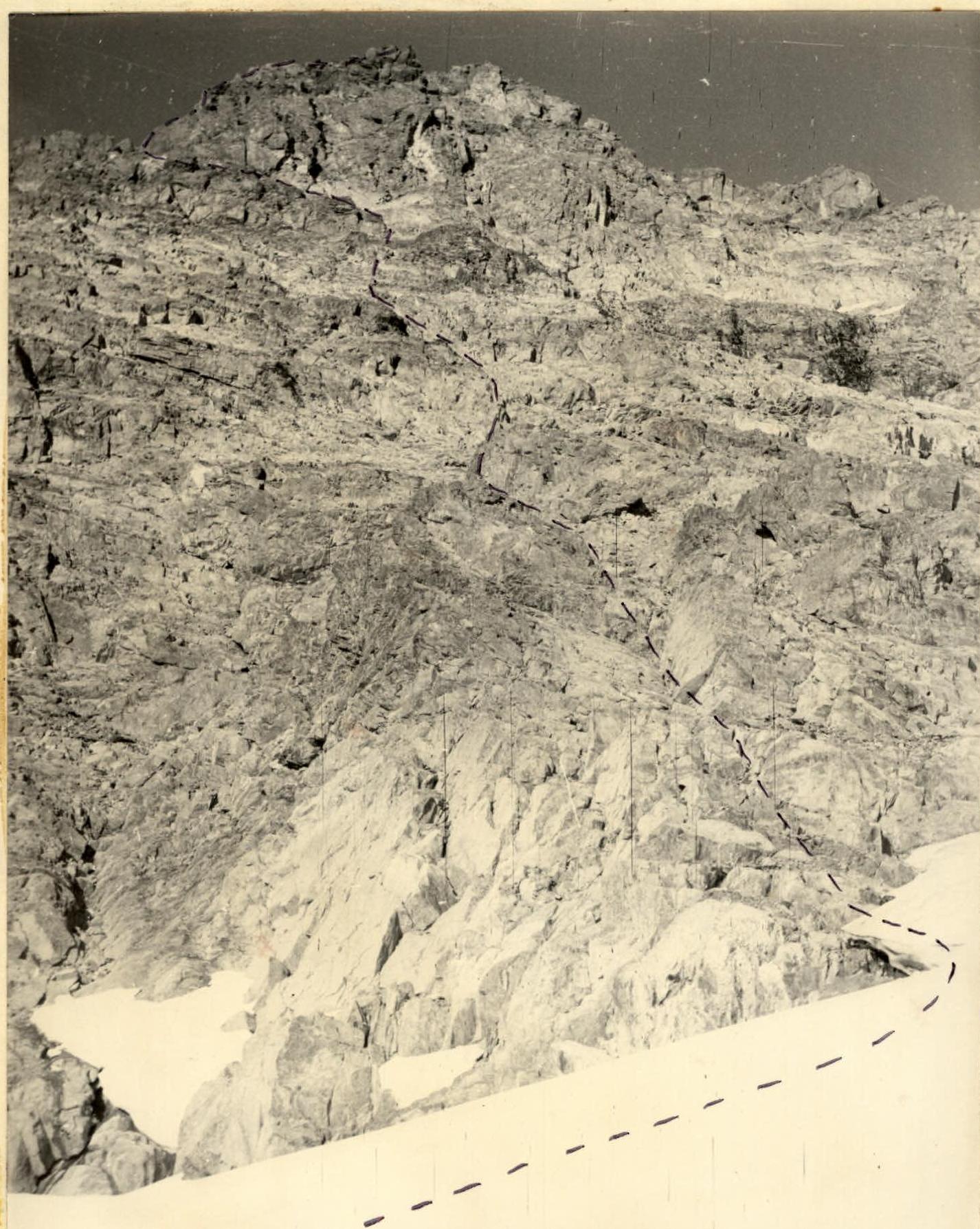
From the pass along ledges and layered rocks with a small gain in height, we exit under the south wall of Academician Kolesnik peak. (1 hour). Overcoming the bergschrund, we exit onto the rocks. The route begins with a 30-meter simple wall, which is climbed with alternating belay through ledges and pitons. There are good holds, convenient for belay ledges. The steepness of the wall is 60–65°. The wall leads to a gap in the ridge before a gendarme. From the gap — onto the ridge. To the right along the way (a detour) to an inclined ledge, which leads to the "gendarme". The "gendarme" is passed on the left with a descent to a snowy saddle between the "gendarme" and the summit. The exit to the summit is via simple rocks. The summit is dome-shaped, heavily destroyed and snow-covered. The height of the summit is 3530 m.
Descent is via the ascent route. The entire path from the base camp to the summit takes 9 hours. Descent from the summit to the glacier takes 1.5–2 hours.
South wall. View from Verkhny Labinsky glacier