On the right side of the southeast wall, 5A (option 4B)
The route passes on the left side of a wide internal corner, which cuts vertically through the entire wall. The internal corner leads to a lowering of the ridge between the peaks of Forossky Kant and Mshatka-Kaya and is a conditional boundary between them. The last section of the route, which passes through a sheer wall with two small ledges, is the most difficult. It can be replaced by an ascent along the несложной upper part of the wide internal corner. In this case, the complexity of the route is reduced by half a category (option).
From the road, near the alpine camps, 200 m up
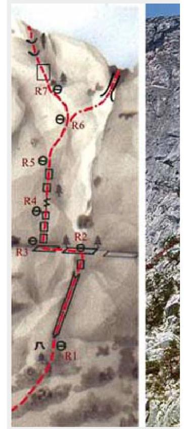
along the trail, and then 50 m along simple rocks to a grotto located at the base of the internal corner (R0: 250 m, 20–40, no tech).
On the section R1–R2 — from the grotto up, first on the right side of the internal corner, and then along smooth slabs to a long horizontal shelf. Further (section R2–R3), traverse along the shelf 20 m to the left (R1–R2: 40 m, 70°, III+; 20 m, 70°, II).
On the section R3–R5 — up along a steep, smooth wall with a small number of cracks (R3–R5: 30 m, 75°, V+; 50 m, 75°, V).
On the section R5–R6 — up and to the right along rocks of medium complexity (R5–R6: 40 m, 70°, III).
On the section R6–R7 — up and to the left 20 m along simple rocks to the base of a large vertical internal corner (R6–R7: 20 m, 60°, I).
On the last section of the route — up along the left sheer 30-meter wall of the internal corner with two small ledges. The ledges are passed head-on (R7–peak: 30 m, 80°, V+).
Option (4B). On the section R6–peak — first up and to the right to a large internal corner, which is the boundary between the peaks, and then along it up to the summit plateau (R6–peak: 50 m, 60°, I).
The length of the main part of the route is about 230 m. The time taken to complete the route is 3–5 hours.
