Kilse-Burun — 2
Via the third counterfort of the western part of the massif (a question), 2B category
The approach to the route begins slightly west of the campsite under Kilse-Burun, 50 m east of the "36/18" kilometer post of the old highway. First, left along the trail, and then up simple rocks to the exit to a long inclined terrace. Along it, 100 m to the right and up. Then turn left and ascend simple rocks to a small terrace at the base of a small rock circus located between the third and fourth counterforts of the western part of the massif (R0 section).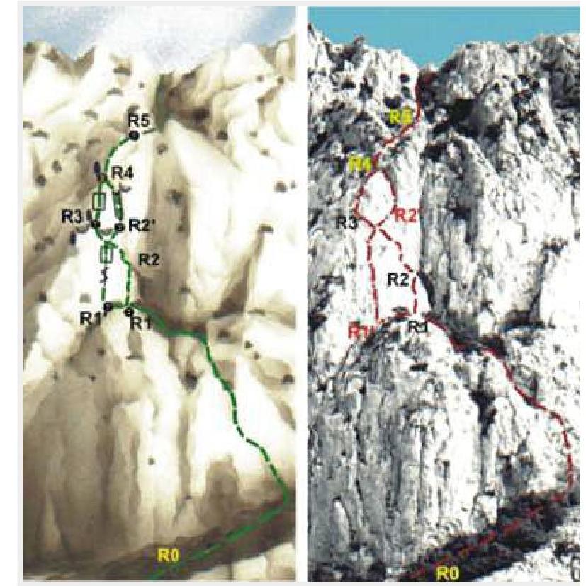
On the R1–R2 section — in the central part of the obscured wall:
- initially 35 m up and to the right in the direction of a small ledge
(R1–R2: 40 m, 75°, IV+).
On the R2–R3 section — initially a little up, and then up and left to a separate pine on the ridge of the counterfort (R2–R3: 30 m, 75°, IV+).
Further, routes #2 and #3 coincide. On the R3–R4 section — from the pine 10 m up and to the right along a 10-meter steep internal corner, and then 30 m up and left along the ridge (R3–R4: 10 m, 80°, IV+; 30 m, 70°, III).
On the R4–R5 section — up 80 m along the ridge of the counterfort to the exit to a large terrace. On it, the main part of the route ends (R4–R5: 80 m, 70°, III).
Along the terrace (R5 section — yayla):
- initially a little to the right,
- then up along a gentle, tree-covered couloir to the exit to the summit plateau (R5 — yayla: 200 m, 30°, no category).
Alternative: traverse left to a shelf under the central part of the counterfort. On the R1'–R2' section — from the terrace, a small traverse along the steep wall to the left to a large, somewhat destroyed groove. Then up the destroyed groove to a narrow shelf. The overhanging wall is bypassed on the left and then to the pine on the ridge along the main route variant. However, there is also an alternative here. The overhanging wall is bypassed on the right. Along the shelf, traverse 15 m to the right and up, bypassing the overhang, to an 8-meter vertical internal corner (R1'–R2': 30 m, 80°, V-; 15 m, 75°, III).
On the R2'–R4 section — initially up the internal corner, and then left and up along a narrow shelf to the ridge of the counterfort. The further part of the route coincides with the main variant (R2'–R4: 10 m, 80°, V-; 30 m, 75°, IV).
The length of the main part of the route is 190 m. The ascent takes 3–4 hours.