Arfen-Cher-Burun — 2
Author: Pavel Slyusar, Kiev
The story of climbing the "Rodeo" route 6A, VI, A3, 300 m
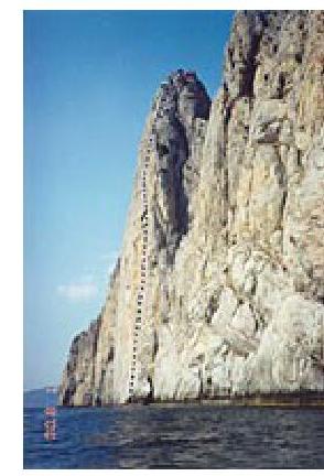
To the southeast of Balaklava, approximately eight kilometers along the coastline, a 240-meter-high rock wall rises from the sea. This wall is a triangular-shaped cliff that closes the southwestern spur of the Arfen-Cher-Burun peak and is separated from the main massif by a deep gap. You can approach the foot of the wall by sea:
- in about an hour from Balaklava
- in half an hour from the Batiliman tract (Laspi settlement)
The wall is striking in its steepness, regularity of shape, and smoothness of relief. It rises vertically from the sea and plunges just as vertically into the blue abyss to a depth of more than 80 meters.
In the right part of the wall, like a silent guardian, a huge black cornice ominously overhangs the sea.
When you sail away into the open sea, it becomes impossible to visually determine the proportions of the wall and the exact distance to it. Questions arise:
- How many meters to the wall — 50 or 250?
- How tall would a person be against the background of this rock?
- How high is the peak — 100, 200, 300 meters?
This effect is apparently created by the sharp contrast between the horizontal surface of the sea and the стремительная verticality of the rock.
I first saw this peak in the summer of 1992, sailing on a ship from Sevastopol towards Yalta. Its beauty stood out sharply among the other peaks of the Ai-Petri massif, captivating and challenging. The idea to climb the wall was born immediately, and, as it turned out soon, not just mine.
In the same year, climbers from Sevastopol reached the summit:
- Alexander Lyapunov
- Sergey Streltsov
They climbed through the center of the "triangle" and named their route "Mirage".
I decided to lay my own route on the wall — through its right, overhanging part, via the black cornice. My partner in the rope team was a rock climber from Zhytomyr, Mikhail Kalnichenko, my long-time friend and constant rival in competitions. In June 2000, we successfully climbed this route and named it "Rodeo", which quite corresponds to its character, technical complexity, and our emotions and feelings during the ascent. It all started like this. In August 1995, we went under the wall for reconnaissance. We needed to clarify all possible aspects of the upcoming ascent, including:
- the location of the base camp,
- the ways to approach, under the wall,
- the technical complexity of the route and the tactics of the ascent,
- the mountaineering and bivouac equipment,
- the weather conditions in the area,
- the state of the sea,
- possible risk factors.
It immediately became clear that this wall could not be taken by a single attempt, and that a prepared expedition, good equipment, and high athletic form of the climbers were necessary for a reliable ascent.
We set up a base camp in the so-called Lost World, a small section of the coast between the Batiliman tract and our peak, separated from the "mainland" by sheer cliffs.
For a week, we made daily forays under the wall on an inflatable rubber boat, which took approximately 25–50 minutes one way, depending on the degree of sea disturbance and wind direction.
As a result of these outings, we:
- collected extensive and interesting photo and video material,
- made necessary visual observations,
- identified key points of the future route and the technical complexity of its different sections,
- studied the character of the relief,
- developed tactics for the future ascent.
In a word, we figured out what and how to do to reach the summit.
We returned under the wall in August 1998, well-prepared and equipped, with the most serious intentions. For three working days, we climbed approximately 100 meters from the sea along the wall's mirror, after which we were stopped by bad weather and a strong storm.
How to "grab" onto the rock when approaching it closely on an inflatable boat? It is very important not to damage the boat on the sharp edges of the mussels stuck to the rock, or else serious problems are inevitable (the nearest shore is a kilometer and a half away). This process is quite complex, since, as a rule, there is a fresh wave on the sea with an amplitude of 1 meter or more. It is not easy to stand up to your full height in the bottom of a flimsy boat, which is either lifted by the crest of a wave or plunges down rapidly!
After gathering your strength and making a decision, you take a step and, with the help of a skyhook, secure yourself to a barely noticeable ledge on the smooth surface of the rock. After the boat sails away, you remain alone over the sea at the foot of the wall that stretches up to the sky, with the oncoming wave constantly threatening to soak you and wash you into the sea.
It's slippery and steep — but you have to climb: it's already impossible to return to the boat "dry". For the next eight meters ahead of you, the task is to organize the first station, preferably without falling into the water with all your gear and rock shoes.
Only when this stage is successfully completed and both participants in the ascent reach the initial insurance point without significant losses, does normal "sixth-grade" climbing begin.
When telling the story of the ascent later, I heard the comment more than once: "Think, falling into the water is not scary at all and completely safe: what's the depth under the wall? 80 meters? Nonsense, you won't reach the bottom". We don't know for sure if that's true — we, fortunately, didn't fall into the water, and we didn't have any serious falls or "flights" at all (we did get caught in a strong storm on a rubber boat and got turned over — that was it). But according to our estimates, falling with a full set of "hardware" onto the water's surface from a height of 10–20–30 or more meters can lead to unpredictable consequences. Therefore, we climbed without haste and with full awareness of responsibility.
We came back under the route to conquer it in mid-June 2000. For five days in a row (from June 14 to 18), we waited out the bad weather and storm until the mountain finally "let" us in. The water in the sea was so mixed up that its temperature dropped to 9 °C. The sun gradually warmed the air, but it was still cold from the sea for another week, like from a refrigerator.
In short, we didn't feel like swimming, so we climbed carefully but quickly. Having passed the familiar lower part, we successfully overcame the upper, overhanging part of the wall. On June 23, 2000, at 17:00, we reached the summit.
It should be noted that the route keeps you in tension and doesn't allow you to relax throughout its entire length. The upper part seemed most difficult to us — the approach to the "black cornice" with a balcony overhang of more than 10 meters, passing the cornice itself in its right part, and exiting onto the gray slabs above the cornice. This section overhangs the water's surface, making you think about a lot of things. During its passage, the rock hook I dropped fell straight into the sea without touching the wall once.
My partner and I took turns laying the path. I'm grateful to Misha for being able to rely on him in the most difficult moments of the ascent. Often, there was no direct visibility between us, and the wind drowned out the sound commands, but I was always confident that:
- Misha understands my actions and trusts me,
- I won't make a mistake anywhere, because under us is an abyss.
This microclimate between us persisted throughout the ascent and became one of the key components of our success.
The peculiarities of our ascent include:
- a constantly stormy sea,
- a brain-freezing wind,
- rain with hail,
- attempts by the sea guards on a patrol boat to check our documents,
- tourists on excursion ships sailing back and forth across the sea, asking questions about how we plan to descend "from there",
- the scorching sun,
- Balaklava fishermen, restrainedly and silently supporting us,
- birds unexpectedly flying out
From the rock crevices, right from under our hands, unintimidated lizards took flight, living their entire lives on this wall. At the end of each day, filled with struggle and the joy of victories, the Crimean evening arrived, and we, holding our breath, watched a miracle: the hot solar disk melted into the sea right in front of us, pouring new strength and inspiration into our tired bodies and souls.
The most exciting moment was when we stepped onto the summit. Far below us, the sea sparkled in the sun.
The views that opened up from the summit:
- To the west, towards Balaklava — a surprisingly beautiful view with the Injir rocks and the two Sails.
- To the south — somewhere very close, Turkish girls were waving scarves at us and performing a belly dance in our honor (or was it a mirage?).
- To the east — the slender columns of the Nakhimov rocks.
Below, on the big earth, our loved ones were waiting. Above us, there was only the sky, and life was beautiful and wonderful...
Below are the technical details for those who want to share our adventure:
- ascent passport
- technical scheme of the route
- description of the route by sections
- as well as our recommendations for future climbers.
Ascent Passport
- Type of ascent — rock climbing
- Crimea, Ai-Petri massif
- Arfen-Cher-Burun peak, via the right part of the Southwestern wall, "Rodeo" route
- Proposed — 6A category of complexity (first ascent)
- Elevation gain 240 m
Route length — 300 m, wall section length — 250 m, length of sections with 6 category of complexity — 250 m, average steepness of the wall section — 90 degrees.
- Number of pitons driven:
rock pitons 15/12, bolt pitons 33/11, chocks 57/18.
- Time taken 50 hours (5 hours)
- Participants of the ascent:
Slyusar Pavel Borisovich (Kiev), Kalnichenko Mikhail Vasilyevich (Zhytomyr)
- Approach to the route: June 19, 2000
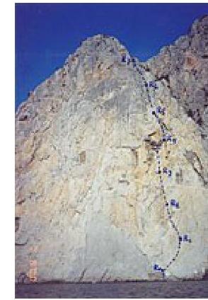
Summit: June 23, 2000. Return: June 23, 2000. Technical scheme of the "Rodeo" route
Description of the Route by Sections
R0–R1: The start of the route is from the water — an overhang with a steepness of 95–100°. It is climbed using skyhooks. The starting point of the route is marked by an inscription on the rock "Route Rodeo, 23.06.2000". At a height of 8 meters above the water, two bolt pitons are driven, on which a reliable belay can be organized.
The path then goes:
- right and up through a system of micro-cracks.
Insurance is provided using small-sized chocks. In the middle of the section, a bolt piton is driven. Climbing is very tense. At the insurance point, two powerful bolt pitons are driven. The insurance point is hanging, under an overhang, safe.
R1–R2: The section begins with a 4-meter overhang, which is climbed using free climbing. Then follows a system of walls and vertical slots.
The possibility of organizing insurance is limited by the poverty of the relief and steepness. On the section, two powerful rock pitons and two good bolt pitons are driven.
The insurance point is hanging on good bolt pitons.
R2–R3: The section is a system of overhanging brows leading to a ledge — the so-called nest. A good, reliable insurance point. Powerful bolt pitons. A semi-sitting overnight stay is possible with the ability to prepare food. Here you can wait out bad weather, covering yourself with:
- a tent
- a cloak
R3–R4: A complex overhanging section leading under the cornices. Climbing is very tense. Insurance is provided using small- and medium-sized chocks. Four good bolt pitons are driven. The relief is a system of blind slots and walls. Mostly monolithic rocks. The insurance point is semi-hanging, organized on two good bolt pitons in a convenient, protected place.
R4–R6: The key section of the route. An overhanging slot under the cornices. Climbing is very complex, mainly using artificial aids and skyhooks. Five bolt pitons are driven.
The section R5–R6 is a bend in the wall, the most overhanging part of the route. The movement goes left and up under the cornices over a deep abyss 200 meters above the water.
Insurance points:
- Reliable
- Organized in convenient places
- Protected
- Powerful bolt pitons are used.
R6–R7: Complex climbing on slabs, insurance is organized using:
- small chocks,
- friends,
- pitons.
The section leads to the ridge.
R7–R8: The ridge section can hardly be called easy: it's a system of ledges and overhanging brows. It is climbed using free climbing. Insurance is provided using pitons and chocks.
R8: The summit is a horizontal area of 2×2 meters with a growing tree. A convenient place to rest.
Remarks and Recommendations
- The ascent took five working days with the organization of fixed ropes and descents along the ascent route for overnight stays in the Lost World (30 minutes by inflatable boat across the sea to the east).
- On the route, it is necessary to have a supply of drinking water and medications in case of a possible wait.
- The sun illuminates the route at 12:00 and sets at 20:30 in June. Work on the route is recommended to start at 6–7 am.
- From the summit, a descent is possible not only along the ascent route but also along the ledges into the Kazen-Dere tract (to the west). This is the route taken by A. Lyapunov's group after their ascent.
- The control tour is in a plastic can tied to a tree on the summit.
- The necessary set of equipment should include two ropes (belay and fixed), a set of chocks and friends, rock pitons, as well as jumar and descender devices for each participant in the ascent. Stations and several intermediate belay points are already made on reliable bolt pitons. The optimal group size is two people plus observers on the water. The route is clearly visible from the sea, and voice communication is possible.
- The route is complex but logical and passes through monolithic rocks. In case of strong wind, it is necessary to provide a system of commands between partners.
- Given the unstable weather on the sea, it is always necessary to have a backup plan for emergency descent and clothing in case of wind or rain. Also, keep in mind that the watercraft (inflatable boat, yawl, or boat) used to deliver the team under the route and evacuate from under the route is subject to the entire spectrum of marine elements (waves, storms, rain), so you need to be prepared for the most unexpected turn of events and possible wait on the wall if the boat cannot approach (say, at point R3). This adds additional complexity to the route.
- According to the sea service, the depth of the sea under the route is 80 meters.
- In conditions of good weather (presence of a high-pressure front), a wind constantly blows along the Arfen-Cher-Burun wall in a westerly or easterly direction (coastal breeze). It can be strong enough to make it impossible to approach the route on an inflatable boat even in relatively good, clear weather. This circumstance should be kept in mind to avoid losing time suitable for rock work on the route.
- The first ascenders' breakdown of sections by time was as follows:
Day 1 — R0–R2; Day 2 — R2–R4; Day 3 — R4–R5; Day 4 — R5–R6; Day 5 — R6–R8.
- Descent from the summit along the ascent route into the sea takes 2 hours.
Good luck!