
Report
St. Petersburg Teams
Ascent to Mt. Sengischorr (1113.5 m)

Route via the central counterfort of the NW wall, 2A category of difficulty
First ascent on June 20, 2012, St. Petersburg 2012
Ascent Passport
- Region: Lovozerskie Tundry mountains, valley of the Sengis-yok river, nearest section 8.6 ECTM 2011.
- Mt. Sengischorr, 1113.5 m, via the central counterfort of the NW wall
- Proposed category of difficulty: 2A, first ascent
- Route characteristics: rock climbing
- Elevation gain: 390 m, with 250 m of wall climbing
Route length: 1175 m. Average slope: main part of the route — 50°; total route — 30°
- Pitons left on the route: none
- Team's climbing time: 2.5 hours
- Team leader: Ivanova-Efimova E.N., 3rd sports category
Team members: Shamalo V.P., Master of Sports of Russia International Class
- Coach: Timoshenko T.I., Master of Sports
- Departure from Base Camp (BC) to the route: June 20, 2012, 8:00
Route started: June 20, 2012, 9:00. Reached the summit: June 20, 2012, 11:30. Returned to BC: June 20, 2012, 13:40. Descent from the summit: via the western ridge of Sengischorr, scree and snowfields, non-categorized
-
Organization: FASIL St. Petersburg
-
Person responsible for the report: Ivanova-Efimova E.N. Email and phone: lswm@ya.ru, 8964-325-73-92
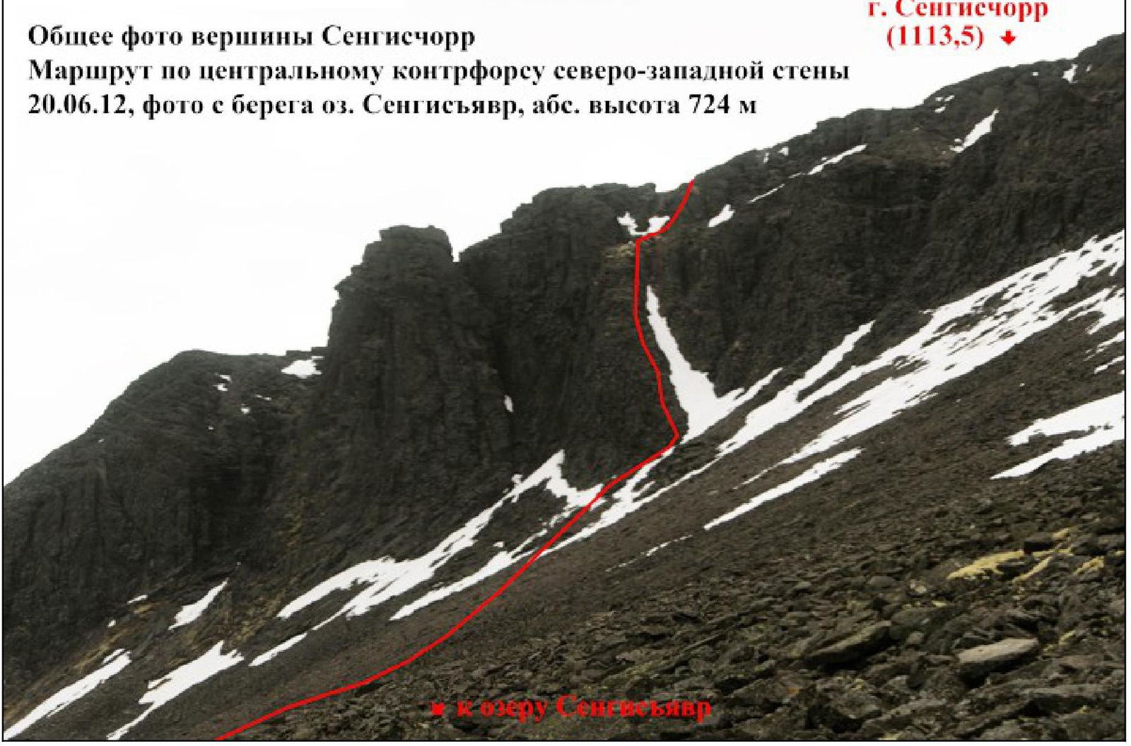
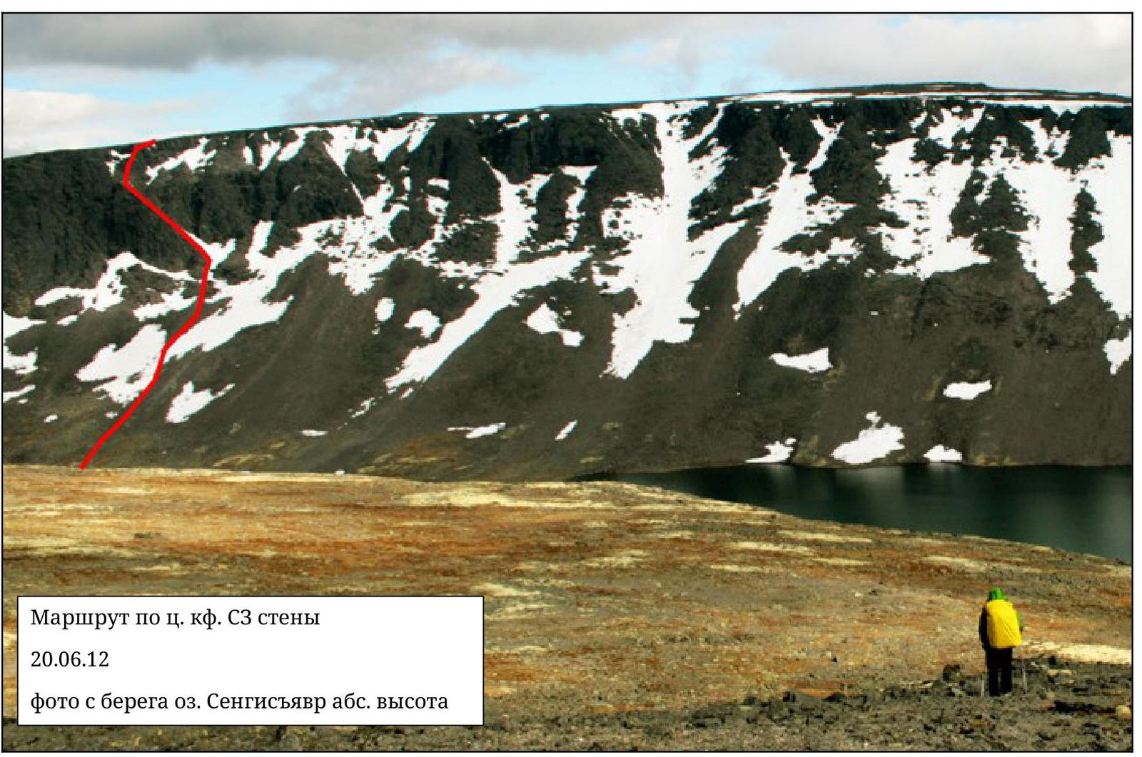
General photo of the summit of Sengischorr
Route via the central counterfort of the NW wall on June 20, 2012, photo taken from the shore of Lake Sengis-yavr, absolute height 724 m
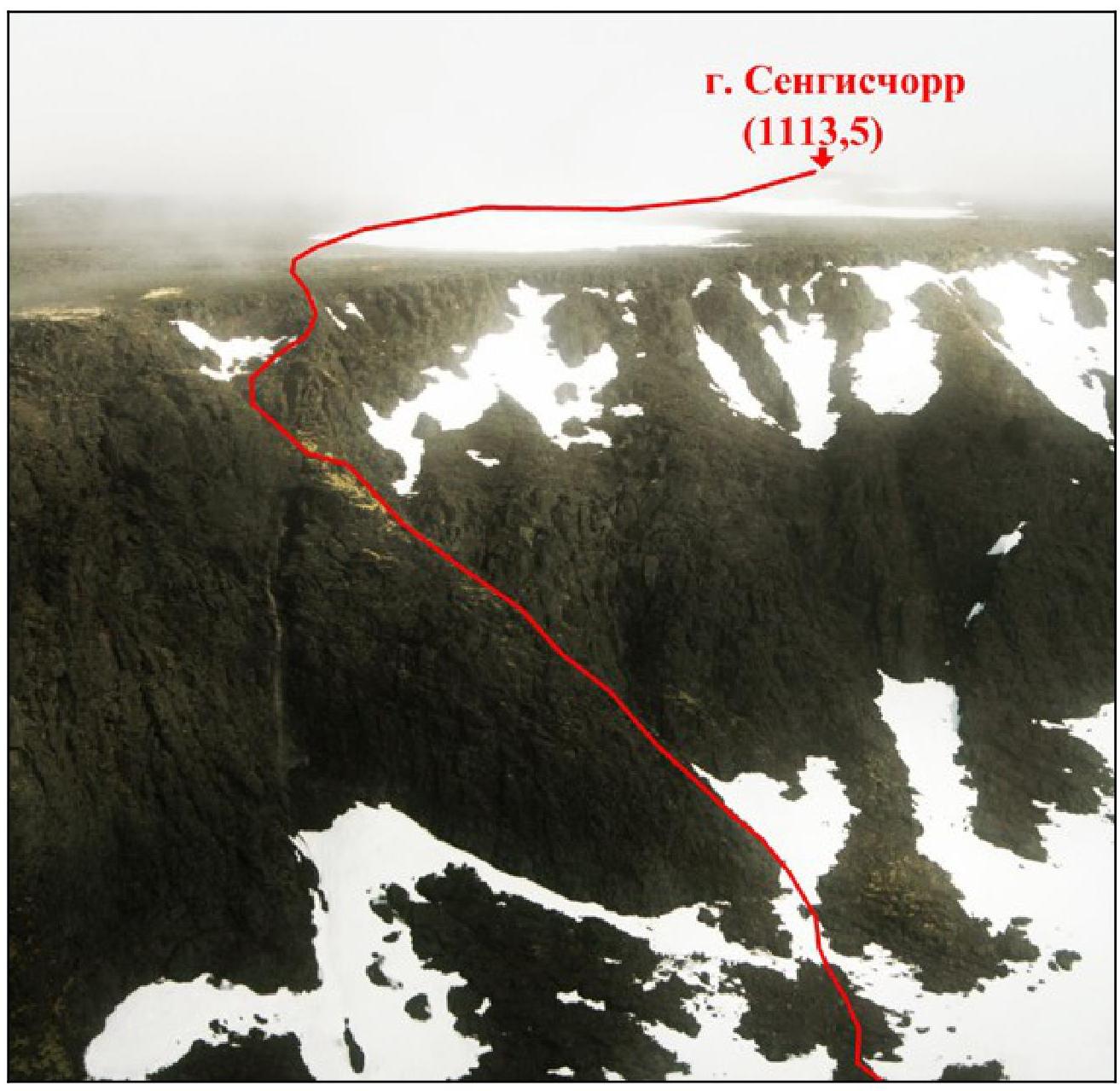
Route Profile (left view)
Route via the central counterfort of the NW wall on June 20, 2012, photo taken from the direction of Mt. Angvundaschorr, height approximately 1070 m

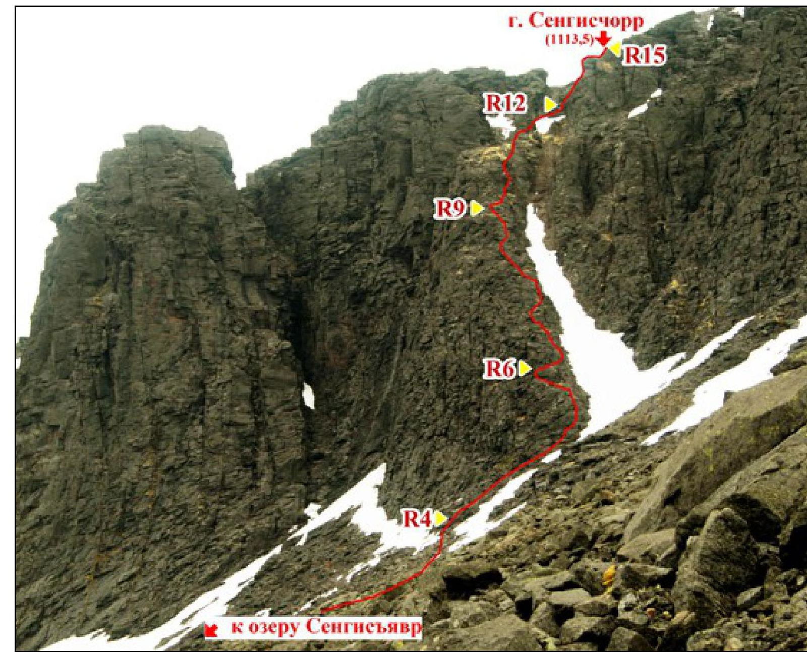
Photopanorama
Route via the central counterfort of the NW wall on June 20, 2012, photo taken from the shore of Lake Sengis-yavr, absolute height 724 m

| 15 km from Uvad | |||||||
|---|---|---|---|---|---|---|---|
| 666.5 | |||||||
| 1120.6 | |||||||
| 1120.6 | |||||||
| 1120.6 | |||||||
| 1120.6 | |||||||
| 1120.6 | |||||||
| 724.0 | |||||||
| 724.0 | |||||||
| 724.0 | |||||||
| 724.0 | |||||||
| 724.0 |
Fragment of map sheet Q-36-10, VG and Q-36-9, VG, scale 1:50 000
Area Overview
Lovozerskie Tundry — a low-mountain massif (highest point — Mt. Angvundaschorr, 1120.6 m), second in size on the Kola Peninsula, located 150 km north of the Arctic Circle. It is bounded by Umbozero to the west and Lovozero to the east. In the northwest of the Lovozerskie Tundry, in the valley of the Ilmajok river, there is the mining settlement of Ilma and 6 km from it — the settlement of Revda.
The most interesting climbing routes are on the walls around Lake Sengis-yavr, the 1st and 2nd cirques of Raslak, the cirque of Lake Rajyavr, as well as many other interesting walls around Lake Seydozero.
The height of the walls reaches 400 m, with many steep and complex sections, and even extended overhanging sections up to 50 m long.
The difficulty of individual routes can reach 5B category.
To reach the area around Lake Sengis-yavr and the cirques of Raslak, one can travel from Olenegorsk by car or bus to Revda. The optimal route to Lake Sengis-yavr then depends on the time of year and the transport available to the group.
In winter, approaches are very difficult due to deep snow and can be made:
- on skis,
- on snowmobiles.
If the group does not have its own snowmobile, it is better to plan 2 days for the journey from Revda to Lake Sengis-yavr in winter.
In summer, a light vehicle can reach the abandoned combine near Lake Umbozero, and from there, follow a very bad road for 4–5 hours to reach Sengis-yavr. With a jeep or truck, one can get even closer, practically to the lake itself.
A base camp can be set up on the shore of Sengis-yavr. The best time for climbing in this area is from July to September. It should be borne in mind that the forest ends in the valley of the Azimut river near the abandoned combine, and there are no trees or firewood on the shores of Sengis-yavr.
Route Diagram
| Section # | Length | Slope | Terrain Characteristics | Category of Difficulty | Number of Pitons |
|---|---|---|---|---|---|
| R1 | 100 | 25 | small and medium scree, snowfields | n/c | - |
| R2 | 200 | 30 | small and medium scree | n/c | - |
| R3 | 50 | 40 | medium scree and rocks | n/c | - |
| R4 | 50 | 45 | rocks up to the ridge | II | - |
| R5 | 40 | 45 | rocks along the ridge | II | - |
| R6 | 10 | 55 | rocks | III | 1 |
| R7 | 30 | 45 | rocks | II | - |
| R8 | 40 | 60 | rocks | III | 2 |
| R9 | 20 | 40 | ledge | II | - |
| R10 | 15 | 60 | rocks | III | 2 |
| R11 | 70 | 30 | ledge | I | - |
| R12 | 70 | 20 | medium scree (around the corner) | I | - |
| R13 | 50 | 40 | rocks to the right | II | - |
| R14 | 30 | 20 | along the ridge | I-II | - |
| R15 | 400 | 10 | walking to the summit | n/c | - |
| R16 | Descent from the northern ridge of Sengischorr via snowfield and scree (n/c) |
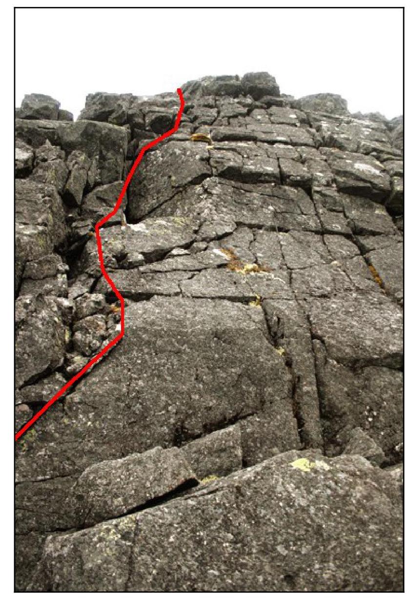
Technical Photographs of the Route
Route via the central counterfort of the NW wall on June 20, 2012
Photo taken from the shore of Lake Sengis-yavr, absolute height 724 m
Description of the Ascent
The group departed from Base Camp near Lake Sengis-yavr on August 20, 1953, at 8:00. The weather was foggy, but we hoped to catch a window when the clouds would lift from the cirque and the walls would become visible. As we approached the lake, this is exactly what happened. After ascending the scree from the lake, we approached the wall and began the ascent. The entire route was climbed using alternate belays. The route is relatively even in difficulty, and it is always possible to find convenient ledges for belaying.
The key sections are the rocks marked on the photographs:
- R6
- R9
- R12
These rocks have a category III difficulty and an average slope of about 60°.
After climbing onto the plateau, it is necessary to walk 400 m to the southwest to the summit — a distinctive group of rocks, where a note is left.
We descended along the slope of the same cirque towards the lake, bypassing the rocks further to the south.
The direction of movement on the route is unambiguous. The only hazard is a small number of loose rocks.
It is possible to climb the first sections to the right via a couloir. Then, with dense firn (in June and early July), crampons will be required, and the route will be combined.
Overall, the difficulty is assessed as 2A category.
Route via the central counterfort of the NW wall on June 20, 2012, Sengischorr, photo taken from the shore
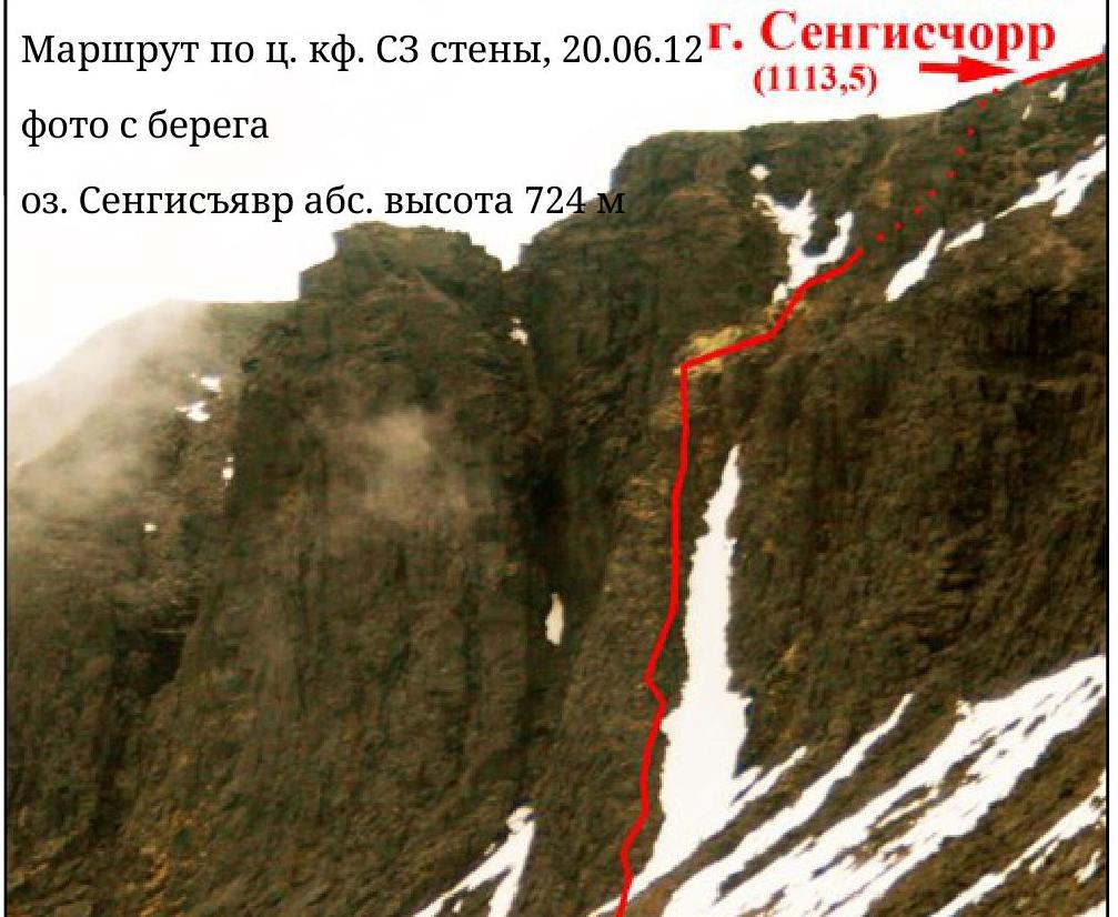
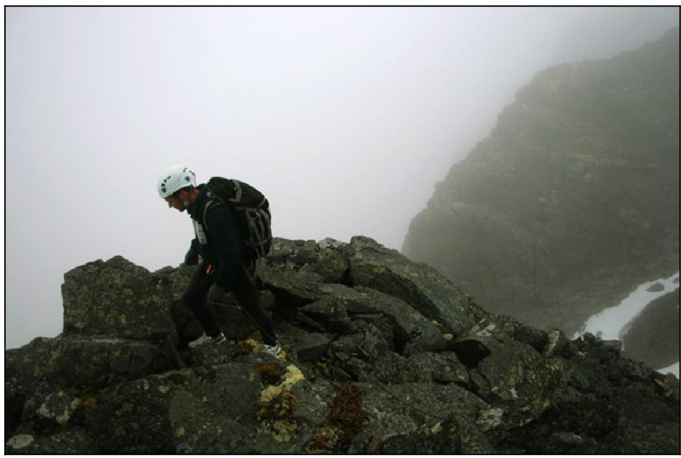
Photo Illustrations of the Report

Rocks R6
Rocks R9
Ledge before rocks R12
Shamalo V. Near the summit
Comments
Sign in to leave a comment