Ascent Passport
1 Northern Urals, Konzhakovsky massif. 2 Yuzhnyy (South) Iov 1311 m — via the N couloir of the slope of Iovskiy breach.
3 Proposed: 1Bz cat. dif., first ascent. 4 Route type: combined. 5 Height difference (by GPS) of the route: 460 m. Route length: 1900 m. Length of sections with III cat. dif.: 150 m. Length of sections with II cat. dif.: 100 m. Steepness of the main part of the route: 45°, on some sections up to 60°.
6 Number of "hooks" left on the route: none. Ice screws used: 2, snow stakes: 4, slings: 4 — all for organizing belays.
7 Departure from the "Serebryansky Kamen" tourist base on March 11, 2014 at 07:50. Departure to the route: March 13, 2014 at 09:45. On the summit: March 13, 2014, 12:55. Descent from the summit to the bivouac (via the central couloir of Iovskiy breach): March 13, 2014, 15:15.
Return to the "Serebryansky Kamen" base: March 13, 2014, 22:15.
8 Team's time on the route — 5 h 30 min. 9 Team leader: Kolunin Ruslan Nikolayevich, 1st sports category, instructor III category, Karpinsk.
Team members:
- Kolunin Ruslan Nikolayevich
23:10. Coach: Yermachek Yuriy Vladimirovich, Master of Sports of the USSR, instructor II category, Yekaterinburg. Organization: Ural High-Mountain Club "Gorets". Person responsible for the report: Kolunin Ruslan Nikolayevich, e-mail: rassel2007@mail.ru, ph. 8 906 857 9003
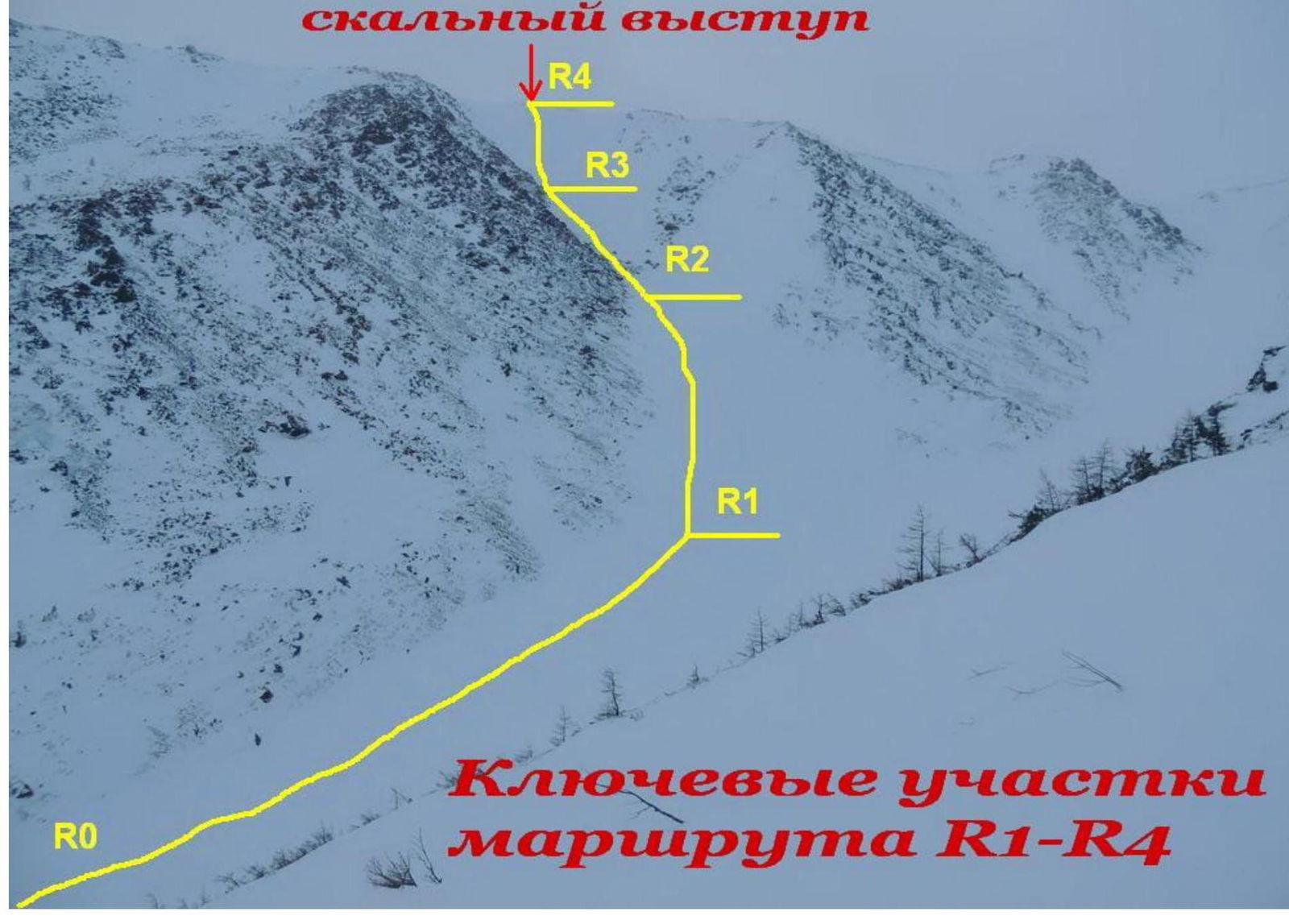
ASCENT ROUTE (PHOTO 1)
- Bogoslovsky Andrey Gennadyevich, 3rd sports category, Krasnoturinsk.
- Khayrutdinov Igor Sergeyevich, 3rd sports category, Krasnoturinsk.
10 Coach: Yermachek Yuriy Vladimirovich, Master of Sports of the USSR, instructor II category, Yekaterinburg. Organization: Ural High-Mountain Club "Gorets". 11 Person responsible for the report: Kolunin Ruslan Nikolayevich, e-mail: rassel2007@mail.ru, ph. 89068579003 ASCENT ROUTE (PHOTO 1)
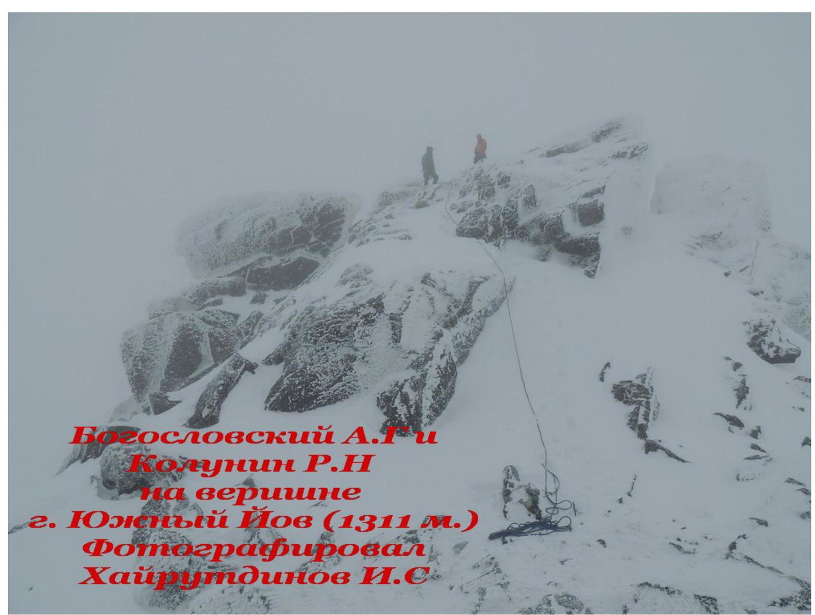
- Yuzhnyy Iov (1311 m)
R5
 Photo
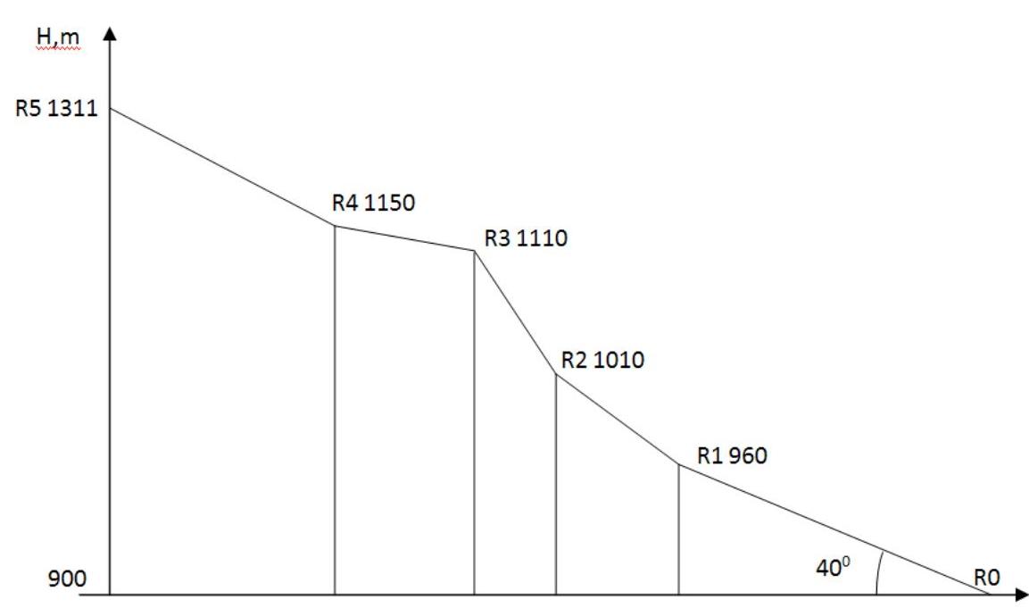
taken from Iovskoye plateau ROUTE PROFILE (PHOTO
2)
Photo
taken from Iovskoye plateau ROUTE PROFILE (PHOTO
2)
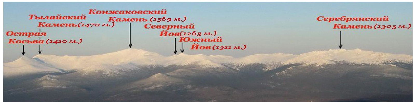
AREA PHOTOPANORAMA (PHOTO
3)
AREA MAP WITH CLASSIFIED ROUTES (PHOTO
4)
Area Description
Material from http://ru.wikipedia.org/↗
Konzhakovsky Kamen is a mountain in the southern part of the Northern Urals, in the Sverdlovsk region (Russia). One of the highest peaks of the Ural Mountains (1569 m).
Composed of:
- pyroxenites
- dunites
- gabbro
The lower parts of the slopes are covered with coniferous forests, and from a height of 900–1000 m — with mountain tundra and stone scree. Named after the hunter-vogul Konzhakov, whose yurt was once located at the foot of the mountain.
The term "Konzhak" among tourists usually refers to the mountain tourist region of the Northern Urals, including several peaks located near the settlement of Kytlym in the Sverdlovsk region within the boundaries of the O-40-023 topographic map sheet. This region includes a ridge, known as the "Konzhakovsky massif", which includes Mt. Konzhakovsky Kamen, stretching predominantly from west to east, as well as several peaks located south and north of this ridge.
The "Konzhakovsky massif" includes:
- Serebryansky ridge to the east (stretches from W to E, height up to 1100–1300 m);
- "Konzhakovsky" ridge to the west (stretches from SW to NE, height up to 1100–1500 m).
Serebryansky ridge includes Mt. Serebryansky Kamen (1305 m) — the highest point of the ridge, characterized by a large number of rocks on the crest (rocky "tooth"), has spurs stretching to the north and south. The northern spur is low and narrow, with a height of up to 997 m, the southern — wide, up to 1100 m.
The "Konzhakovsky" ridge includes peaks:
- Mt. Trapezia (1253 m)
- Mt. Yuzhnyy Iov (1311 m)
- Mt. Severnyy Iov (1256 m)
- Mt. Konzhakovsky Kamen (1569 m)
- Mt. Tylaisky Kamen (1471 m)
- Mt. Ostraya Kosva (1403 m)
Notable features on the ridge include:
- Iovskoye plateau with a height of up to 1100–1200 m with a lake (water level 1125 m)
- Iovskiy breach (eastern slope of the Iovskoye plateau) — rocks, steeply dropping into the valley of the Poludenaya river
- Tylaisky breach — steep southwestern slope of Mt. Tylaisky Kamen
- "Khudozhnikov poliana" — a clearing in the forest in the valley of the Konzhakovka river, a popular spot for campsites
From the Karpinsk–Kytlym highway to the summit of Konzhakovsky Kamen stretches the so-called "marathonka" — a marathon trail with kilometer markings (one-way length — 21 km).
Route Description
To reach the starting point of the route, it is necessary to travel 18 km on skis or snowshoes to the foot of the Konzhakovsky massif. There is also the possibility of using a snowmobile for the approach. The approach to the route from the "Serebryansky Kamen" tourist base or from the Karpinsk — Kytlym road takes from 1 to 2 days. The bivouac is set up on the steep right bank of the Poludenaya river, from the frozen riverbed of which the route begins.
Section R0–R1 is a snow-ice slope (frozen riverbed) with a steepness of 10° at the beginning and up to 30°. Movement should be cautious, as close to the center of the slope as possible, since it is possible to fall into the riverbed in the spring. Movement in crampons with poles in hand. After passing 200 m from the camp along the central couloir, turn left in the direction of the couloir of the northern part of the Iovskiy breach
Section R1–R2 is 100 m long. Steepness: 45°. Movement in a rope team simultaneously through intermediate belay points, organized on ice screws. A section of blue ice. In some places, rocks protrude from the ice. Short ice screws are very suitable for belaying. At the end of the section, a belay station is set up on a rocky outcrop.
Section R2–R3 — a snow-ice slope with a steepness of 50° at the beginning and up to 60° at the end, leading to the plateau. The length of the section is 150 m. Movement along fixed ropes. Belay stations on snow stakes. If a 50 m rope is used as a rope for the section, then at the end of the third rope, a belay station can be organized on a rocky outcrop, on the edge of the plateau. This same rocky outcrop in the form of a triangle is a landmark when moving on section R1–R2
Section R3–R4 — gentle, walked on foot. It is better to put the rope away in a backpack
We move along the Iovskoye plateau to the south, gradually climbing onto the stony scree. The length of the section is 300 m.
Section R4–R5:
- Large-block scree with a slope of 25°.
- It is necessary to choose sections with dense snow.
- The section does not present technical difficulties.
The summit itself is a rocky outcrop with a height of 5–7 m. In strong winds, it is advisable to use belaying when near the summit cairn.
Descent to the bivouac occurs in the direction of Mt. Konzhakovsky Kamen on the plateau and further along the snow-ice central couloir of the Iovskiy breach
Recommended equipment:
- harness
- helmets
- dynamic rope for a rope team 50 m
- crampons
- ice axes
- snow stakes 4 pcs
- ice screws 2 pcs
- long slings 4–5 pcs
Table of Main Route Characteristics
Table 1 — Route Description by Sections
| Section # | Time | Height, m | Length, m | Steepness, deg. | Relief Type | Cat. dif. | Belaying |
|---|---|---|---|---|---|---|---|
| R0 | 09:45 | 900 | 500 | Up to 30° | Snow slope | I | Simultaneous |
| R1 | 10:10 | 960 | 100 | 45° | Ice slope | II | Simultaneous, belaying via ice screws |
| R2 | 10:25 | 1010 | |||||
| R2 | 10:25 | 1010 | 150 | Up to 60° | Snow-ice slope | III | Ropes |
| R3 | 11:50 | 1110 | |||||
| R3 | 11:50 | 1110 | 300 | Up to 15° | Kurum covered with snow | I | - |
| R4 | 12:10 | 1150 | |||||
| R4 | 12:10 | 1150 | 850 | Up to 30° | Large-block scree | I | - |
| R5 | 12:55 | 1311 |
PHOTO FROM THE ROUTE
Triangular Rocky Outcrop
 PHOTO
5
PHOTO
5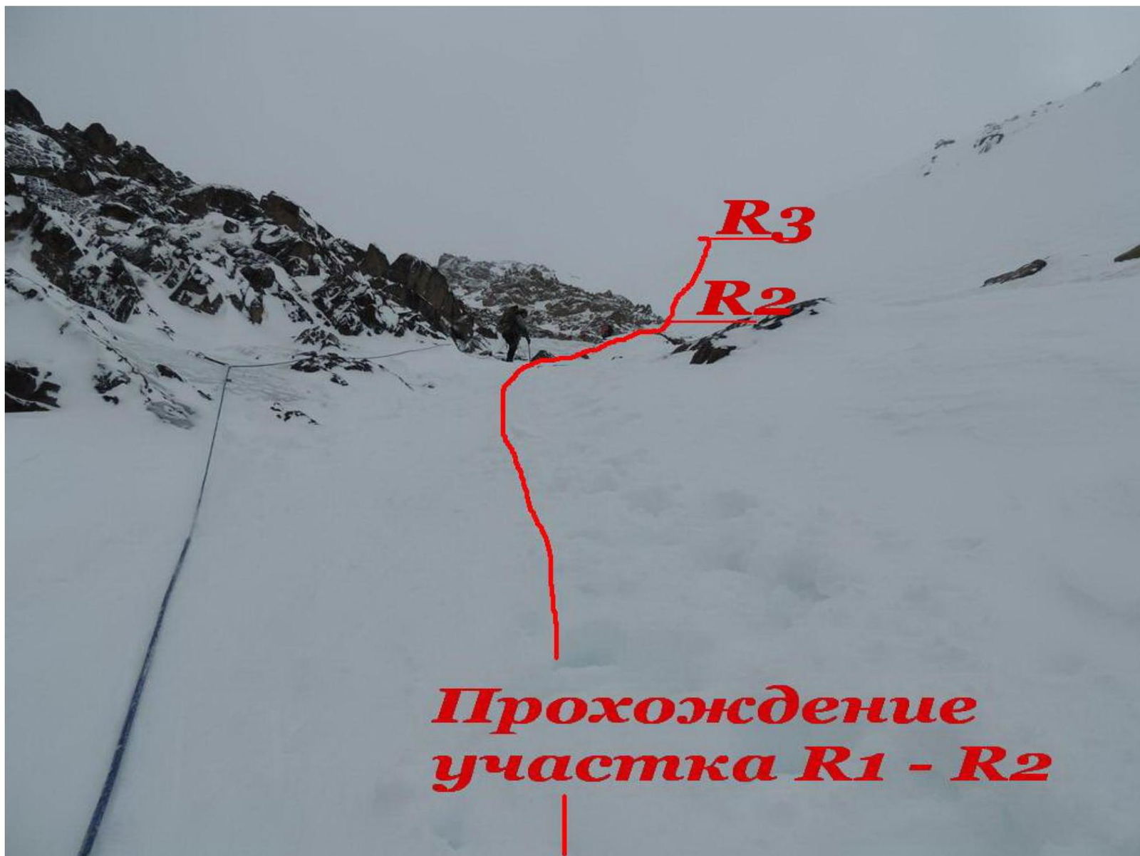
PHOTO 6
PHOTO 7