
Report
ON THE FIRST ASCENT TO THE SUMMIT OF NEROYKA MOUNTAIN VIA THE NORTHEAST RIDGE ROUTE, CATEGORY 1B, BY THE UGRA ADVENTURE TRAVEL CLUB TEAM FROM FEBRUARY 23, 2024, TO FEBRUARY 23, 2024
I. Ascent Passport
| № | 1. General Information | |
|---|---|---|
| 1.1 | Full name, sports rank of the leader, date of birth | Kolunin Ruslan Nikolaevich, 1st sports rank, instructor category III, April 19, 1988 |
| 1.2 | Full name, sports rank of participants, date of birth | Porodov Sergey Borisovich, CMS, July 7, 1958 Spitsyn Pavel Ivanovich, 2nd sports rank, October 21, 1960 Aksenova Olga Ivanovna, 2nd sports rank, April 13, 1973 Safonov Ilya Pavlovich, 3rd sports rank, September 3, 1981 Ilyk Igor Anatolyevich, 3rd sports rank, January 2, 1980 |
| 1.3 | Full name of the coach | Porodov Sergey Borisovich, CMS, July 7, 1958 |
| 1.4 | Organization | Ugra Adventure Travel Club |
| 2. Characteristics of the Ascent Object | ||
| 2.1 | Region | Subpolar Urals, Research Ridge |
| 2.2 | Valley | Shaytanka River valley |
| 2.3 | Section number according to the 2020 classification table | 8 |
| 2.4 | Name and height of the summit | Neroyka 1645 m |
| 2.5 | Geographical coordinates of the summit (latitude/longitude), GPS coordinates | 64°56′02″ N; 59°55′53″ E |
| 3. Characteristics of the Route | ||
| 3.1 | Name of the route | Northeast ridge |
| 3.2 | Proposed category of complexity | 1B |
| 3.3 | Degree of route exploration | First ascent |
| 3.4 | Nature of the route terrain | Combined |
| 3.5 | Elevation gain of the route (according to altimeter or GPS data) | 619 m |
| 3.6 | Length of the route (in meters) | 1550 m |
| 3.7 | Technical elements of the route (total length of sections of varying complexity with indication of terrain type: ice-snow, rocky) | Category I complexity combination — 1100 m Category II complexity combination — 450 m |
| 3.8 | Descent from the summit | Via the ascent route, category 1B, to the Shaytanka River valley |
| 3.9 | Additional characteristics of the route | Water present in the form of snow |
| 4. Characteristics of the Team's Actions | ||
| 4.1 | Time of movement (team's walking hours, in hours and days) | 7 hours 12 minutes |
| 4.2 | Overnights | None |
| 4.3 | Start of the route | 07:58, February 23, 2024 |
| 4.5 | Return to the base camp | 15:10, February 23, 2024 |
| 5. Person Responsible for the Report | ||
| 5.1 | Full name, e-mail | Kolunin Ruslan Nikolaevich, e-mail: rassel2007@mail.ru |
II. Description of the Ascent
1. Characteristics of the Ascent Object
1.1. General photo of the summit. Photo 1. Taken from the plateau on February 23, 2021 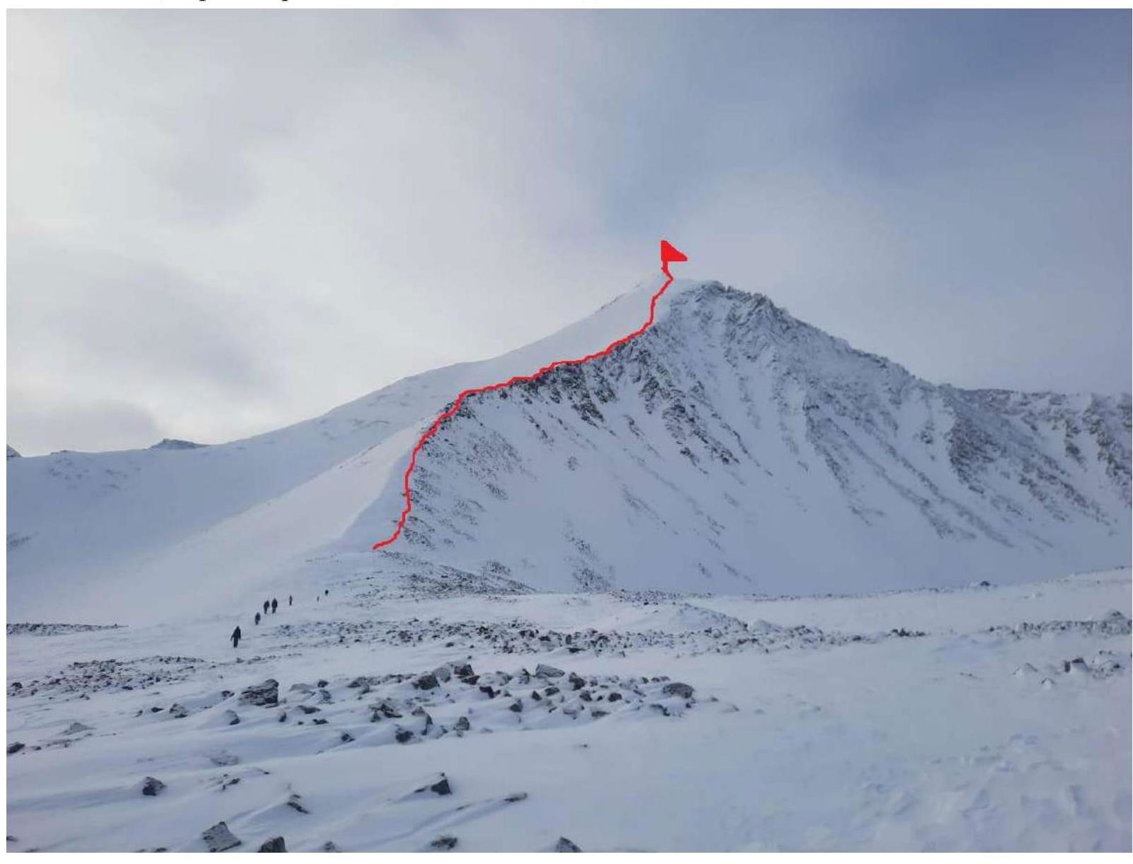 1.2. Photo of the route profile. Photo 2.
 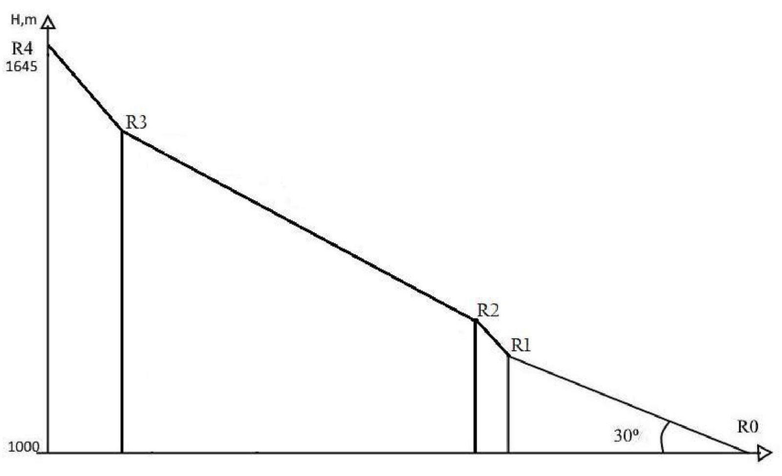 1.3. Photopanorama of the area. Photo 3.
Taken from Mt. Tupaya
1.3. Photopanorama of the area. Photo 3.
Taken from Mt. Tupaya 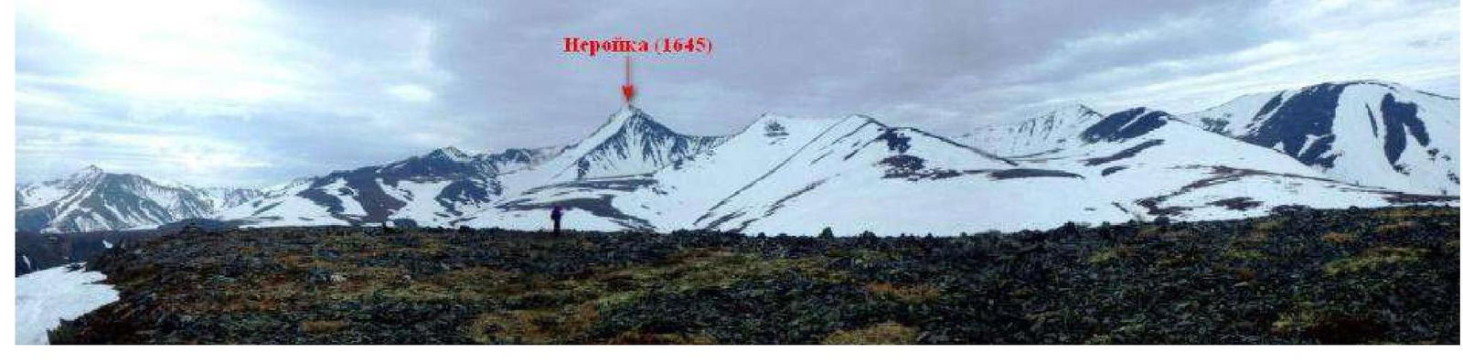
1.4. Map of the area. Photo 4.
Scale 1:200000 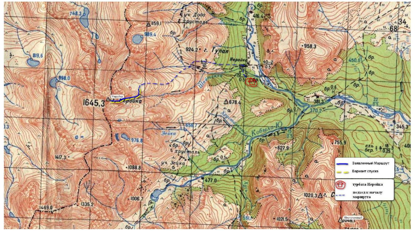
General view of the Ural Ridge in the ascent area. Photo 5. 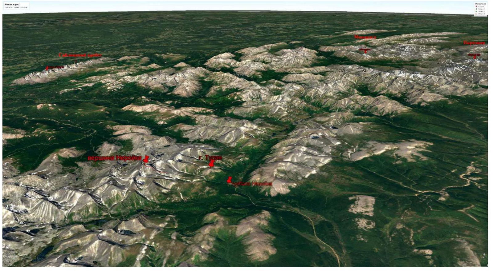
1.5. Description of the Area
Research Ridge is the main watershed ridge of the Subpolar Urals, on the border of the Komi Republic and the Khanty-Mansi Autonomous Okrug — Yugra. Length 175 km. Height up to 1895 m (Mt. Narodnaya — the highest point of the Urals). High-mountain relief prevails, deeply and densely dissected by transverse valleys and gorges. Numerous cirques and glacial lakes are present. On the slopes — mountain-forest swampy taiga landscapes:
- on the western slope with a predominance of spruce,
- on the eastern — larch.
Above 500–800 m — subalpine belt with mountain-tundra landscapes; above 800–1000 m — cold alpine deserts with moving talus, snowfields, and small cirque glaciers. Tourism is developed (mainly skiing and rafting).
Neroyka (Nër-Oyka), a high mountain (1645 m) on the watershed ridge of the Research Ridge, 5 km NNE from the source of the Shchkurya River, a tributary of the Lyapin.
The Mansi name translates to "Old Man-Stone," "Old Man Urals" (nër — "rocky mountain," "ridge," "Urals," oyka — "old man," "master"). Another possible translation is "Master of the Mountains," "Ruler of the Urals" — this is one of a series of Mansi "nëroykas" guarding the Urals. Unfortunately, unlike other "nëroykas," its full name has not been established (if it exists).
Currently, a road has been built from Sarampaul deep into the mountains. The route leads to the geological settlement of Neroyka, located at the foot of the eponymous mountain. Like most similar settlements in the North, it was closed and abandoned in the 1990s. However, mining has resumed recently.
The summit of Neroyka:
- is almost always hidden in gloomy clouds,
- even in summer, freshly fallen snow is not uncommon, creating the image of a gray-haired head.
In fact, the entire Subpolar Urals has alpine landforms, indicating the young age of the mountain-building processes.
The route starts from the "Neroyka" tourist base, located on the outskirts of the eponymous settlement. A geological road leads to the slope of the ridge.
To reach the start of the route, it is necessary to travel 5 km on skis or snowshoes (elevation gain 557 m). Snowmobiles can be used for transportation. The approach to the route from the "Neroyka" tourist base takes about 3 hours.
The technical part of the route:
- Begins from the plateau under the NE ridge.
- The route then follows the ridge line.
2. Characteristics of the Route
2.1. Technical photograph of the route. Photo 6. Taken from the "Neroyka" base on August 22, 2021 
2.2. Technical characteristics of the route sections
| Section № | Terrain type | Category of complexity | Length, m | Type and number of hooks |
|---|---|---|---|---|
| R0–R1 | Rocky ridge, snow-covered | 1 | 500 | 0 |
| R1–R2 | Rocky ridge with snow cornices | 2 | 150 | 2 (loops) |
| R2–R3 | Snow-ice slope | 1 | 600 | 0 |
| R3–R4 | Rocky ridge with snow cornices | 2 | 300 | 4 (snow stakes) |
3. Characteristics of the Team's Actions
3.1. Description of the route passage
| Section № | Description | Photo № |
|---|---|---|
| R0–R1 | Length 500 m. Represents an ascent along a snow-covered ridge. It is necessary to proceed with caution due to deep gaps between rocks covered with snow. The ridge is straightforward, with "shelves." The slope of the ascent ranges from 10° at the beginning to 40°. Movement in crampons with ice axes in hand. | 7 |
| R1–R2 | Length 150 m. Slope from 50° to 60°. Movement in a rope team with alternate belays, in crampons, and with ice axes for each participant. The section consists of two rock walls, one 4 m high, the second 10 m high. The entire section is covered with firm snow. It is necessary to move to the left of the ridge line due to overhanging snow cornices on the ridge. Belays via loops thrown over rock outcrops. At the end of the section — a rock outcrop. | 8 |
| R2–R3 | Length 600 m. From the rock outcrop begins a snow slope leading to the pre-summit ridge. The slope initially has a slope of 40°, and at the end, near the ridge, it reaches 60°. At the exit to the pre-summit ridge, ice under the snow is possible. After snowfall, it can be avalanche-prone! Movement along the slope is simultaneous in a rope team. On this section, the ridge line strongly deviates to the left, and one must be cautious of cornices on the right side. | - |
| R3–R4 | Length 300 m. The pre-summit ridge connects the N ridge, NE ridge, and SE ridge. Then begins an ascent in a SW direction to a large rock outcrop. This is the key section of the route with the steepest slopes, reaching 65°. The ridge has cornices along its entire length on the right side of the movement. It is necessary to ascend to the left of the ridge along the steep southern slope. Belays are most reliable when using snow stakes. Belays are alternate. The summit represents a small area in the widening of the ridge. On the summit, a geodetic pillar is installed, which is almost completely covered with snow. In 2021, an aluminum commemorative plaque in the form of the new coat of arms of KhMAO — Yugra was installed on the summit of Neroyka, in honor of the 90th anniversary of the formation of the Khanty-Mansi Autonomous Okrug. | 9 |
Photo 7. Section R0–R1. Snow-covered ridge 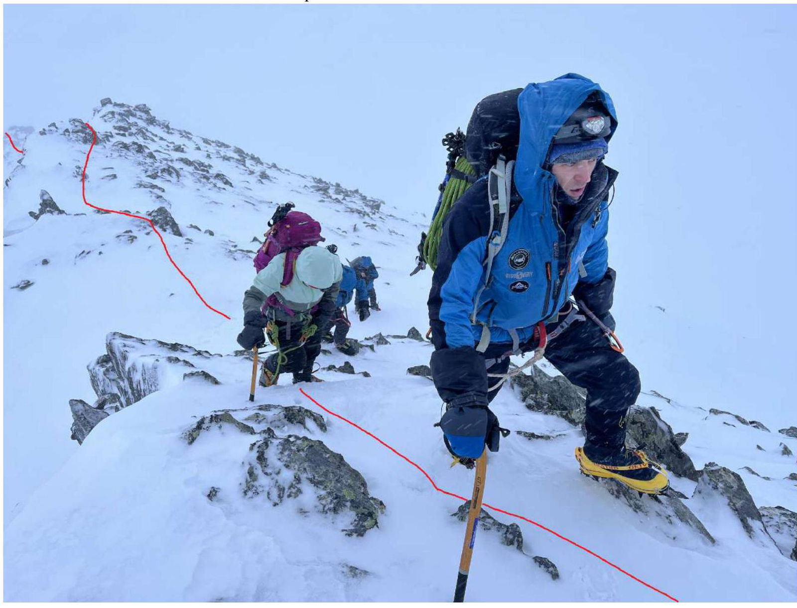
Photo 8. Section R1–R2. Passage of one of the rock walls 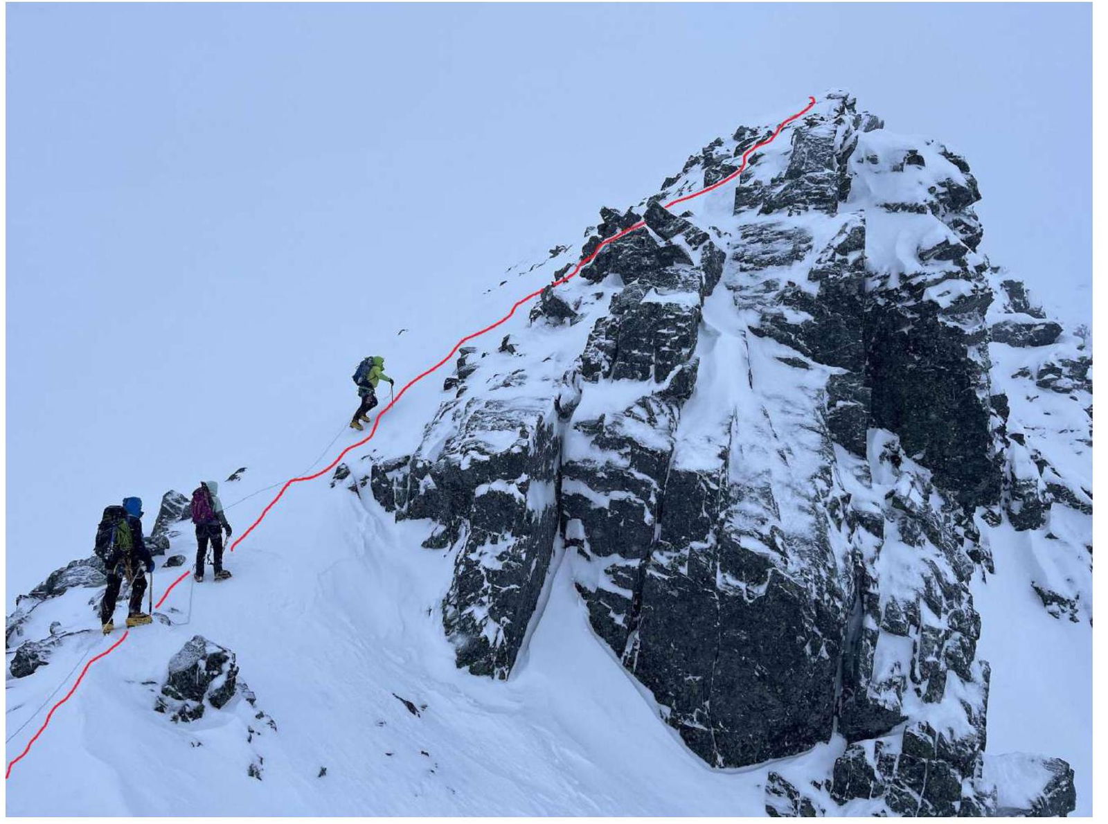
Photo 9. Section R3–R4. Processing the pre-summit ridge. Kolunin R. N. is leading 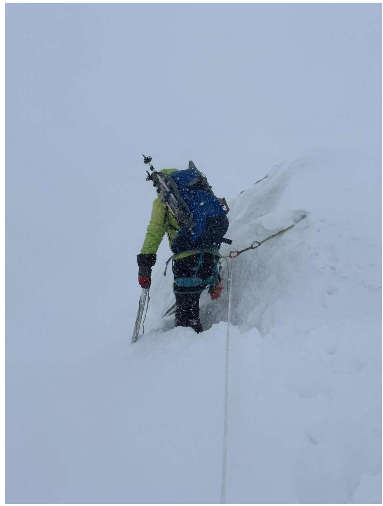
3.2. Photo of the team on the summit near the control marker. Photo 10. 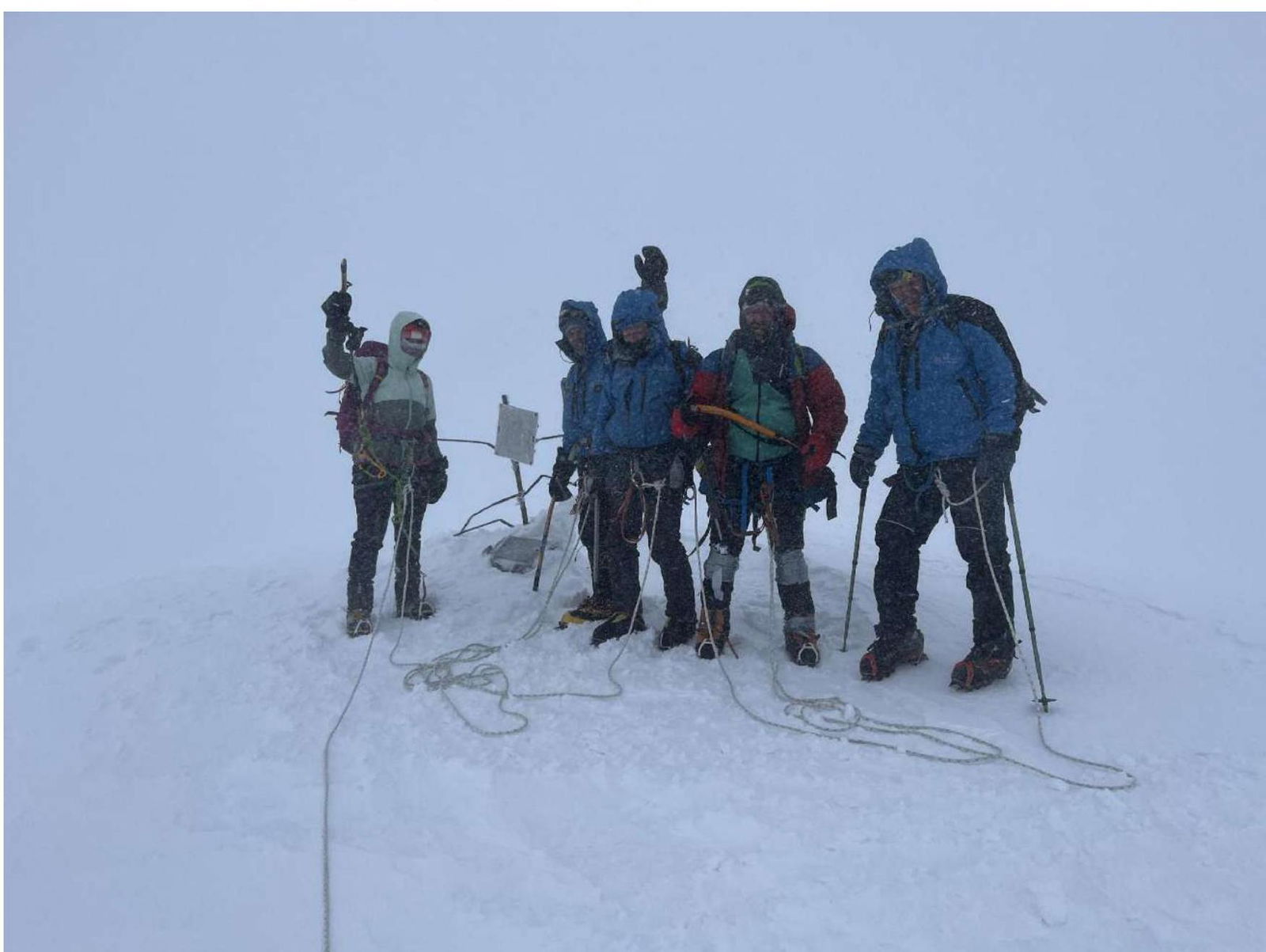
The descent occurs along the ascent route. The route is logical and can be used as a training route. However, it is worth noting that in winter:
- Cornice formation occurs on the northern wall, making it hazardous.
- On the approaches to the route, it is necessary to use navigation tools since there are no clear landmarks.
- Climbers must be prepared for a sharp change in weather conditions due to the continental climate.
Recommended equipment for a team of 6 people: harnesses, crampons, helmets, ice axes for each participant.
Group equipment:
- dynamic rope for a rope team 40 m
- snow stakes — 4 pcs.
- runners — 6 pcs.
- loops 120 cm – 2 pcs.
In summer, it is necessary to have a set of rock protection devices.
Comments
Sign in to leave a comment