Ascent Passport
- Subpolar Urals, Sablinsky ridge, section 8.3.
- SABLYA peak (1497 m), right part of the central NE wall.
- Proposed 6A category of difficulty, first ascent.
- Route type: combined.
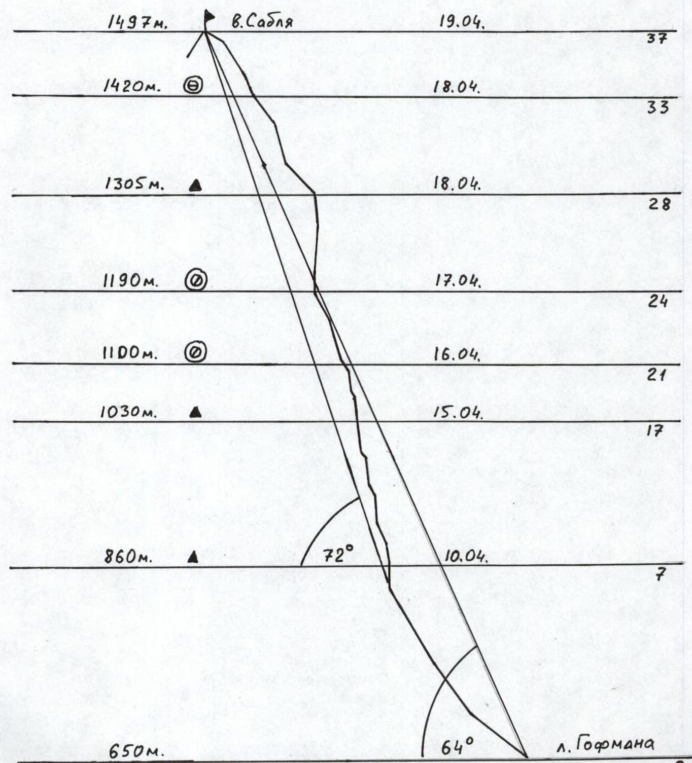
- Height difference: 850 m, route length: 1010 m.
Length of sections:
- 5th category of difficulty – 270 m.
- 6th category of difficulty – 140 m.
Average steepness:
- main part of the route — 72°
- entire route — 64°
- "Hooks" left on the route: total — 15; including bolted — 3.
"Hooks" used on the route:
- bolted stationary — 1
- removable — 2.
Total artificial protection points (APs) used — 124.
- Team's working hours: 67 h, 10 days.
- Team leader: Puchnin Vyacheslav Evgenevich, Master of Sports.
Team members: Zaitsev Yuri Anatolyevich, 1st sports category; Malafeev Vladimir Ivanovich, 1st sports category.
- Coach: Puchnin Vyacheslav Evgenevich, Master of Sports.
- Departure to the route: 12:30, April 8, 2002.
Reached the summit: 13:10, April 19, 2002. Returned to Base Camp: 17:00, April 19, 2002.
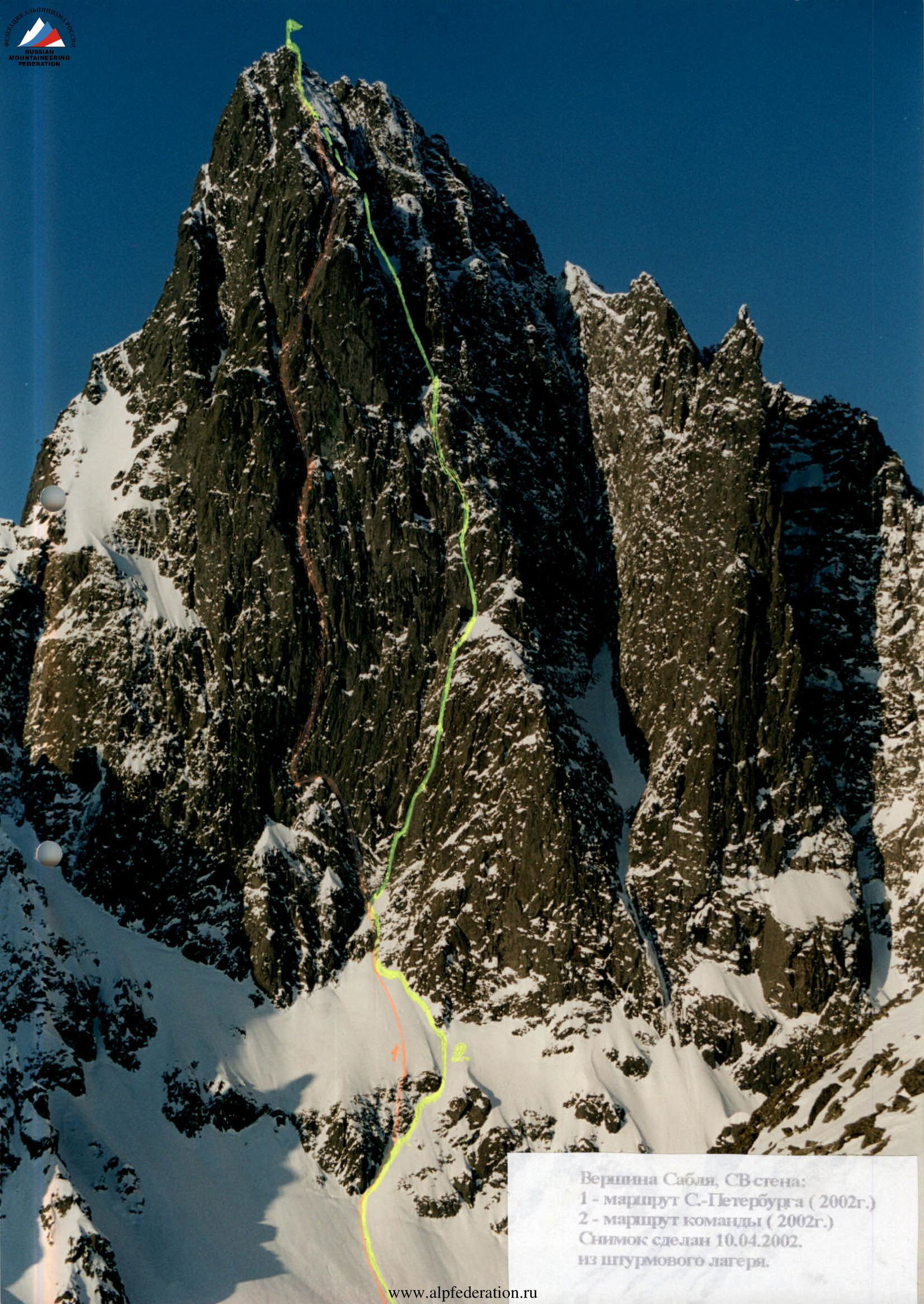
Sablya peak, NE wall:
- St. Petersburg team route (2002)
- Our team route (2002) Photo taken on April 10, 2002, from the assault camp.
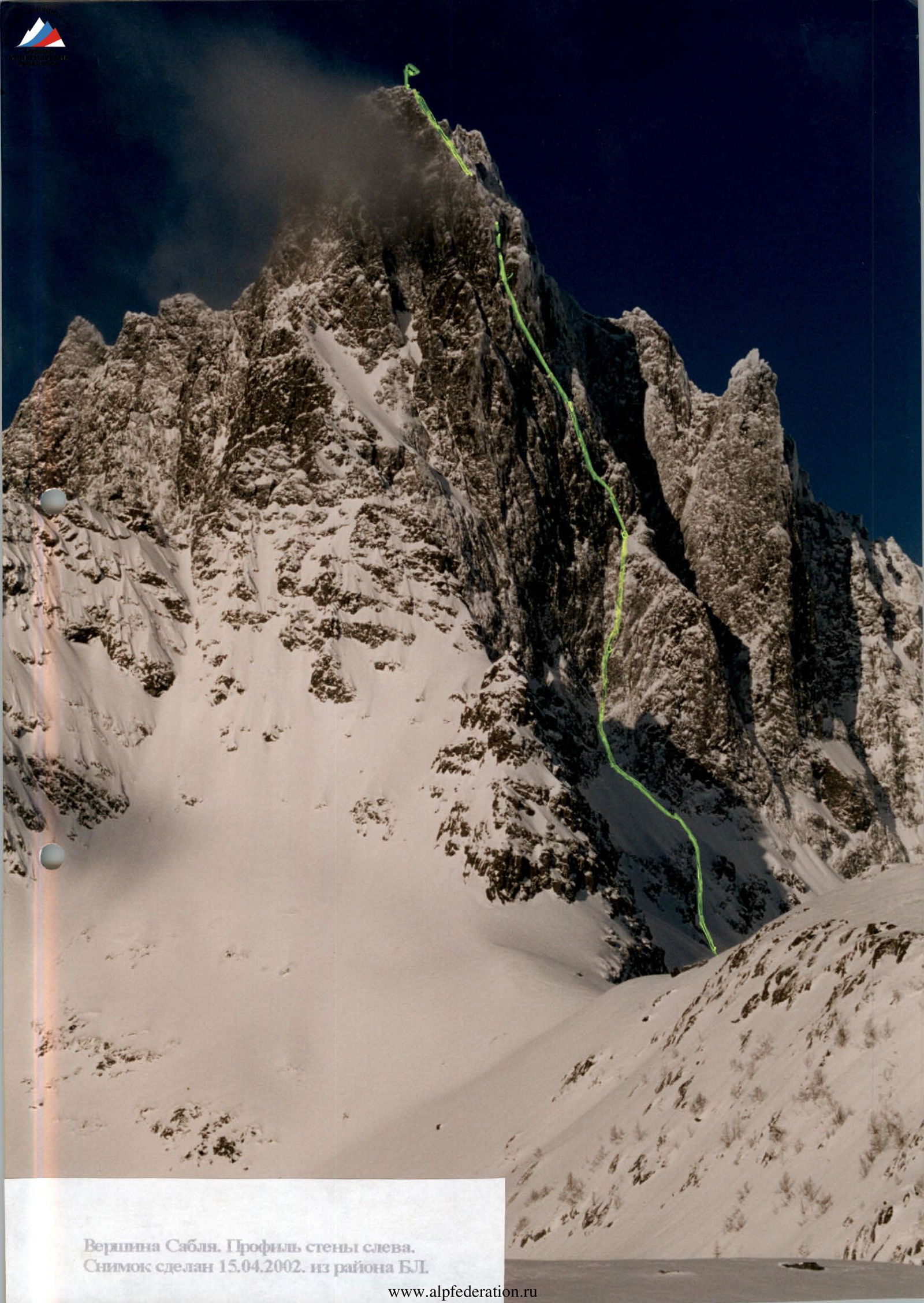
Sablya peak. Profile of the left wall. Drawn profile of the route. Scale: 1 cm — 50 m
Scale 1:100 000. Panorama of the central part of the Sablinsky ridge. From left to right:
- Sablya
- Svartaknada
- North Sablya.
Photo taken on April 9, 2002, from the base camp area.
Brief overview of the area
The Sablinsky ridge is located in the Komi Republic, in the southwestern part of the Subpolar Urals within the "Yugyd-Va" national park, oriented from north to south, approximately 30 km long. The western slopes of the ridge are gentle, while the eastern slopes, due to weathering and glacial activity, drop off with cliffs having a height difference of 200–700 m. The highest point of the ridge is Mount Sablya (1497 m). The classic ascent path from the west via a couloir was classified as 2A in 1990. Ascents via the Eastern ridge (Perm – 1992, St. Petersburg – 2000) and the Southeast wall (Perm – 1992, Syktyvkar – 2001) are not included in the classifier.
In summer:
- approaches to the ridge are swampy,
- weather is unstable,
- rocks are weathered and characterized by a large amount of moss and lichen.
In winter, the main challenges are:
- short subpolar day,
- low temperatures (down to –50°C),
- strong winds.
Therefore, the optimal time for complex wall ascents in this area, in our opinion, is spring, specifically March–April. It is during this time that:
- the area warms up,
- days are longer,
- it is still possible to approach and descend on skis or snowmobiles.
The Subpolar Urals are very popular among tourists from Russia and nearby foreign countries, who have laid numerous ski, hiking, and water routes. All the most well-known and significant peaks in the area (Manaraga, Narodnaya, Sablya, Kolokolnya) have been ascended by tourists in the 30s–50s, and some of these routes are included in the KTMGV. Along the main routes, national park staff have set up huts with a supply of firewood (Kushnik, Sunduk, Aranetsky pass, etc.). Payment for staying in the reserve area can be made both by non-cash payment and directly in Pechora.
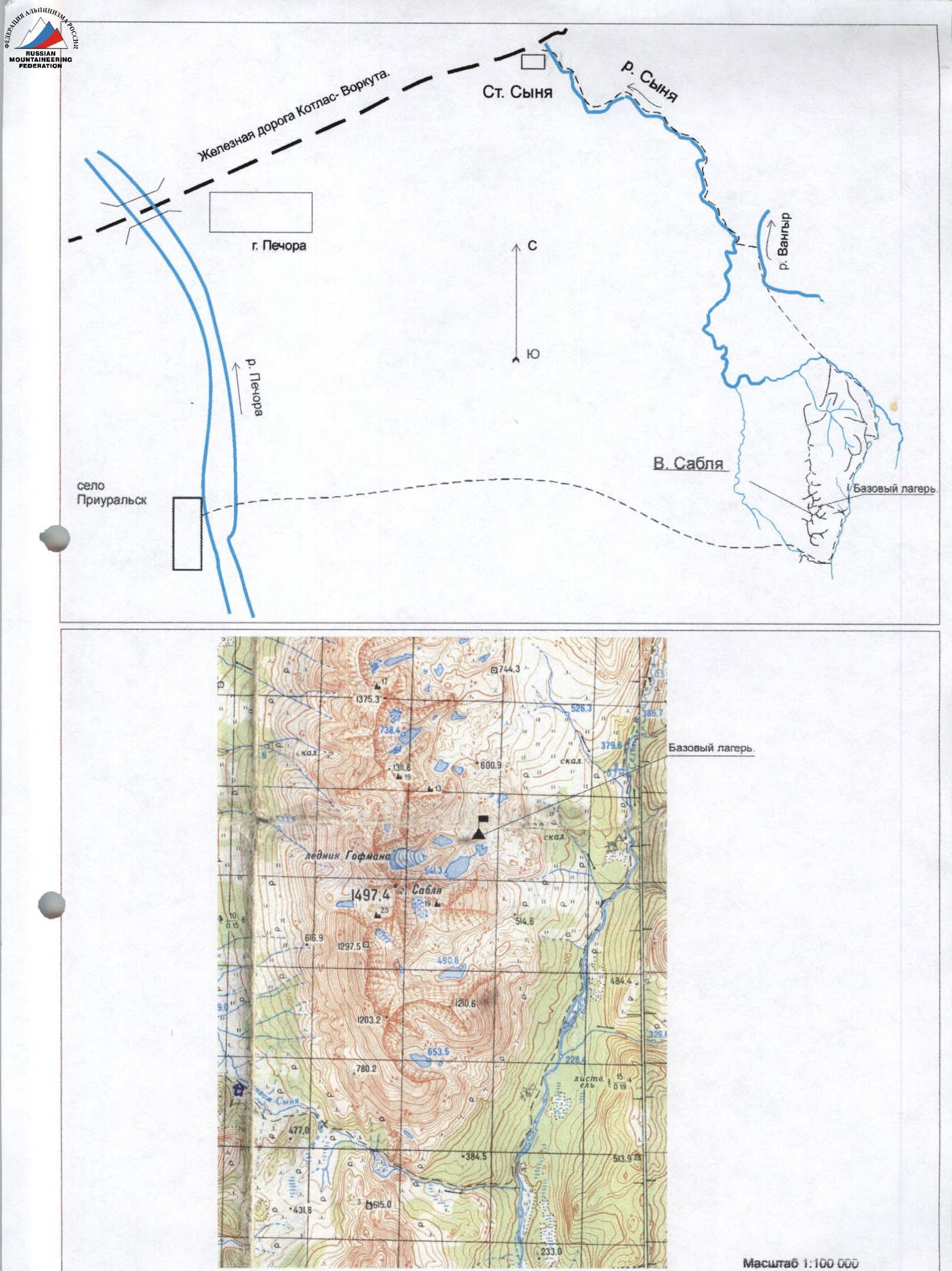
Access to the area:
- by train from Pechora station to Synya station (1 hour)
- by winter road to Aranets or Priuralsky settlement (2–4 hours depending on road conditions)
- in summer — by river (3–4 hours)
Approaches to the NE wall of Sablya are possible:
- from the Pechora river (Aranets or Priuralsky settlement) through the Aranetsky pass (65–70 km; 3–4 working days in summer, 2–3 days on skis, 3–5 hours by snowmobile),
- from Synya railway station via clearings and rivers (110–115 km; problematic in summer, 4–5 days on skis, 7–9 hours by snowmobile).
Helicopter delivery is possible (40 minutes flight from Pechora), but due to unfavorable weather, waiting for a flight can take several days.
The base camp can be conveniently set up on the forest edge under the spur that separates the NE and SE walls of Sablya peak. From here:
- to Gofman's glacier — 30–40 minutes,
- to the route — 60–70 minutes.
The assault camp can be set up:
- on the moraine ridge opposite the wall (20–25 minutes to the route),
- on the glacier under the wall (8–10 minutes to the route), but in this case, the assault camp may be in an avalanche zone.
Descent from the summit:
- via the ascent route to the assault camp,
- via the 2A route (from the Western circus — 5 km to the hut near the Aranetsky pass).
| ice | cams | pitons | bolts | sect. | M | cat. | angle |
|---|---|---|---|---|---|---|---|
| – | 5/3 | 5/3 | – | R11 | 35 | 5А2 | 80–85 |
| – | 4 | 2 | – | R10 | 10 | 4 | 60 |
| – | 5 | 2 | – | R9 | 20 | 4 | 65 |
| – | 6/5 | 5/5 | 1 | R8 | 25 | 5А3 | 85 |
| – | 6/4 | 5/4 | – | R7 | 30 | 5–6А2 | 85–95 |
| – | 3 | 2 | – | R6 | 20 | 4 | 60 |
| – | 1 | – | – | R5 | 25 | 3 | 60 |
| – | 2 | 2 | – | R4 | 25 | 4 | 60 |
| – | 3 | 3 | – | R3 | 45 | 4 | 60 |
| – | 4 | 3 | – | R2 | 105 | 2 | 55–60 |
| – | 1 | 2 | – | R1 | 90 | 2 | 25–55 |
| ice | cams | pitons | bolts | sect. | M | cat. | angle |
|---|---|---|---|---|---|---|---|
| – | 8/7 | 10/8 | – | R26 | 35 | 5А3 | 90–95 |
| – | 5/3 | 6/4 | – | R25 | 15 | 5А1 | 75 |
| – | 2 | 4 | 1 | R24 | 40 | 4–5 | 65 |
| – | 3/2 | 3/2 | – | R23 | 15 | 5А2 | 80 |
| – | 5/4 | 4/2 | – | R22 | 30 | 5А2 | 70 |
| – | 2 | 1 | 1 | R21 | 10 | 4 | 55 |
| – | 5/4 | 4/2 | – | R20 | 20 | 5А2 | 85 |
| – | 2 | 2 | – | R19 | 20 | 4 | 65 |
| – | 3/3 | 2/1 | – | R18 | 15 | 5А2 | 85 |
| – | 6/3 | 4/2 | – | R17 | 15 | 5А2 | 80 |
| – | 7/6 | 9/8 | – | R16 | 20 | 5А2–5А3 | 85–95 |
| – | 3 | 1 | – | R15 | 10 | 4 | 60 |
| – | 2 | – | – | R14 | 10 | 4 | 65 |
| – | 5/3 | 3/2 | – | R13 | 35 | 5А2 | 80–85 |
| – | 3 | 3 | – | R12 | 10 | 4 | 60 |
| ice | cams | pitons | bolts | sect. | M | cat. | angle |
|---|---|---|---|---|---|---|---|
| – | 1 | – | – | R37 | 20 | 3 | 30 |
| – | 3 | 2 | – | R36 | 30 | 4 | 55 |
| – | 2 | 1 | – | R35 | 20 | 4 | 60 |
| – | 4/2 | 3/2 | – | R34 | 15 | 5А1 | 65 |
| – | 4 | 3 | – | R33 | 45 | 4 | 55 |
| – | 5/3 | 3/2 | – | R32 | 20 | 5А1 | 75 |
| – | 4 | 4 | – | R31 | 30 | 4 | 70 |
| – | 2 | 2 | – | R30 | 45 | 3 | 45 |
| – | 3 | – | – | R29 | 5 | 4 | 75 |
| – | 6/6 | 9/8 | – | R28 | 35 | 5А2 | 80 |
| – | 8/6 | 5/5 | – | R27 | 15 | 5А2 | 90–95 |
Route description by sections
R0–R1 — a snowy slope of increasing steepness leads to the base of a large rock island. Safe location. R1–R3 — across snow and "ram's foreheads" covered in snow — to the rock wall at the base of the wall. Protection on rocks, movement under their cover. R3–R5 — traverse under an internal corner, ascent upwards and slightly left across snow to the base of a crevice leading left. Start of the St. Petersburg route. R5–R6 — along the boundary between snow and rocks, then upwards to the right across snowy rocks to approach the base of a vertical chimney. R6–R7 — entry into the chimney is bypassed on the left using skyhooks, then APs lead up the chimney to a sloping ledge. Here is the 1st control point. R7–R8 — further slightly to the right into a vertical crevice, APs. At the exit from the crevice — a bolt. Everything is filled with snow. R8–R11 — from the bolt up a wide chimney and small walls filled with snow — into a steep narrow chimney filled with snow. R11–R14 — upwards and slightly left across a system of walls, R4–R11. Ascent to the top of the counterfort across snowy "ram's foreheads". R14–R15 — upwards and to the right under a vertical crevice. R15–R17 — upwards under a large overhang, complex APs. The overhang is bypassed on the left across a steep chimney filled with snow (APs) to a sloping ledge. Here is the 2nd control point. R17–R21 — across a steep wall (APs) and a ridge covered in snow, exit via a crevice (APs) to a snowy patch. In the upper part of the patch on a rock wall — a descent, a safe location for a bivouac. R21–R24 — upwards and to the left across a system of walls (APs) to snowy "ram's foreheads". Along them — vertically upwards to the base of a large rock bastion. At the base of the bastion — a descent, a convenient and safe location for a bivouac. R24–R26 — from the bivouac upwards across a wall (APs) to a jammed friend. From here — a pendulum to the left into a vertical crevice. Upwards across it. Complex APs, icy rocks. R26–R29 — upwards, bypassing overhangs (APs) to a rock balcony and a snowy patch. At the exit, to the right under an overhang — the 3rd control point. R29–R30 — across snow to the base of a large internal corner. The ridge is visible. R30–R32 — upwards to the full length of the rope, partly APs, rime ice. R32–R33 — from the internal corner to the left across a simple chimney filled with snow and ice. Exit to a snowy col under the summit. Ideal location for a bivouac (on the other side of the ridge — strong gusty wind). R33–R36 — across rocks covered in snow and ice — upwards and to the right to the ridge, partly APs. R36–R37 — upwards and to the left 20 m to the summit across snowy rocks.
Work on section R7–R8.
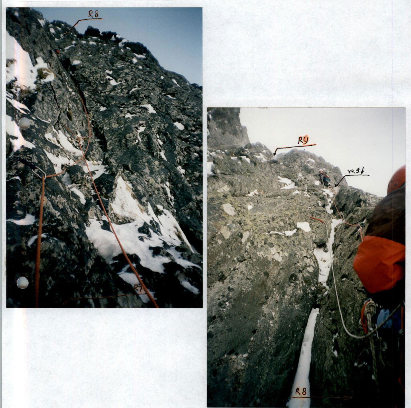
Photo #4. April 11. Section R9–R10.
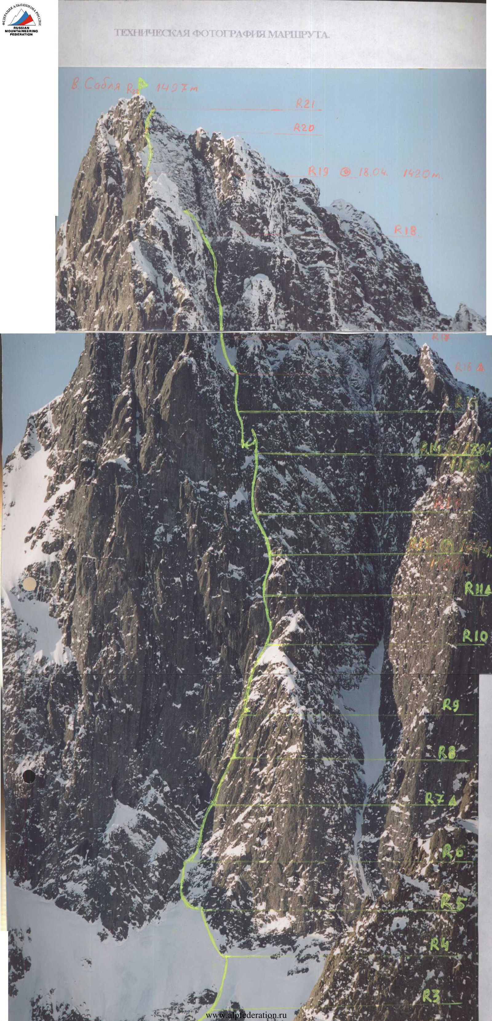
Photo #5. April 14. Section R14–R16.
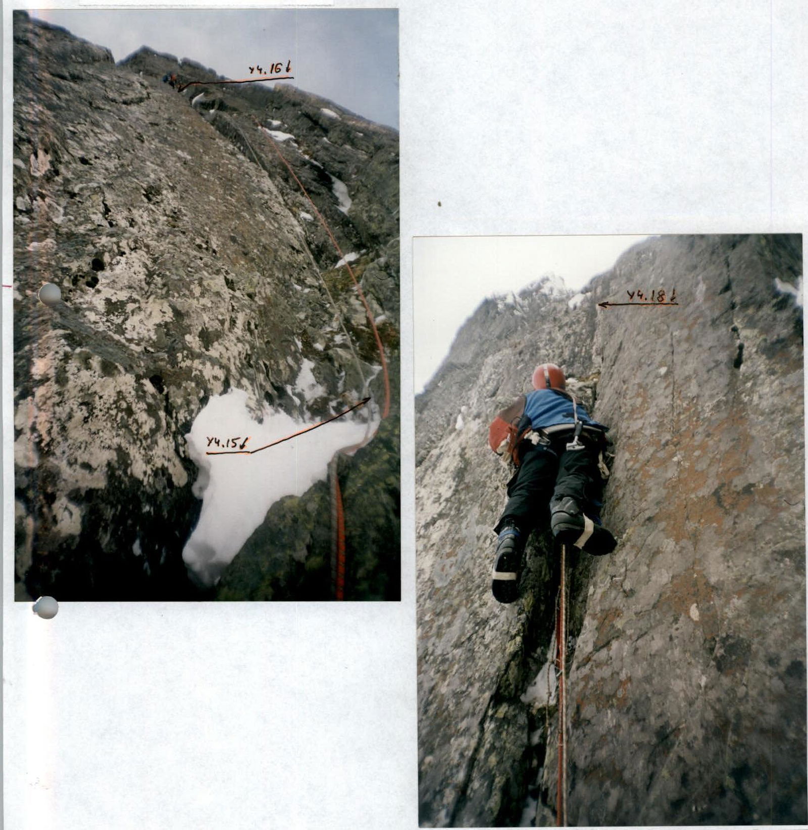
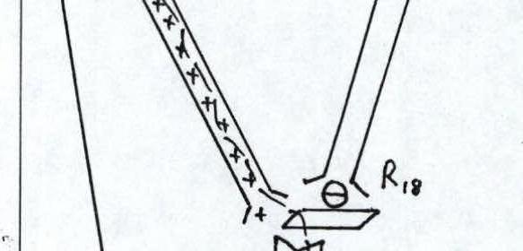
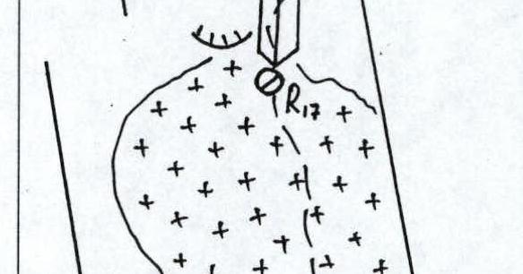
Photo #6. April 15. Section R17–R18. V. Malafeev working.
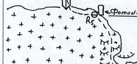
Photo #7. April 15. Section R18–R20.
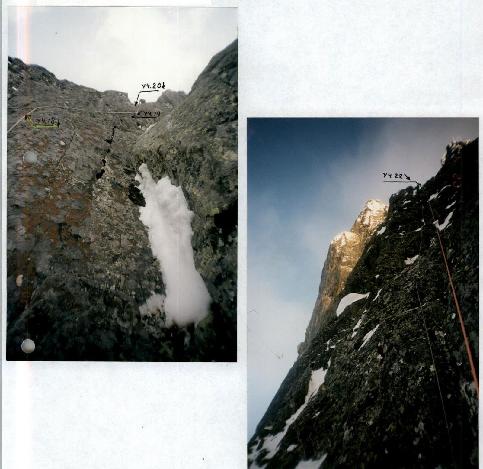
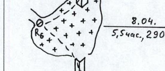
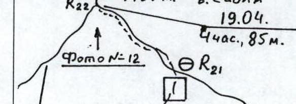
Photo #8. April 16. Section R21–R22.
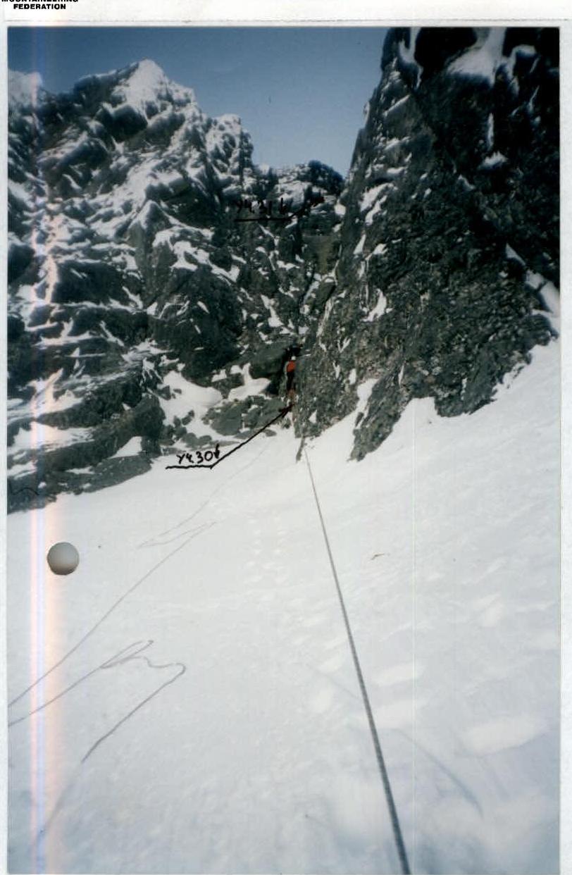
Photo #11. April 18. Section R29–R31. The summit is visible at the top left.
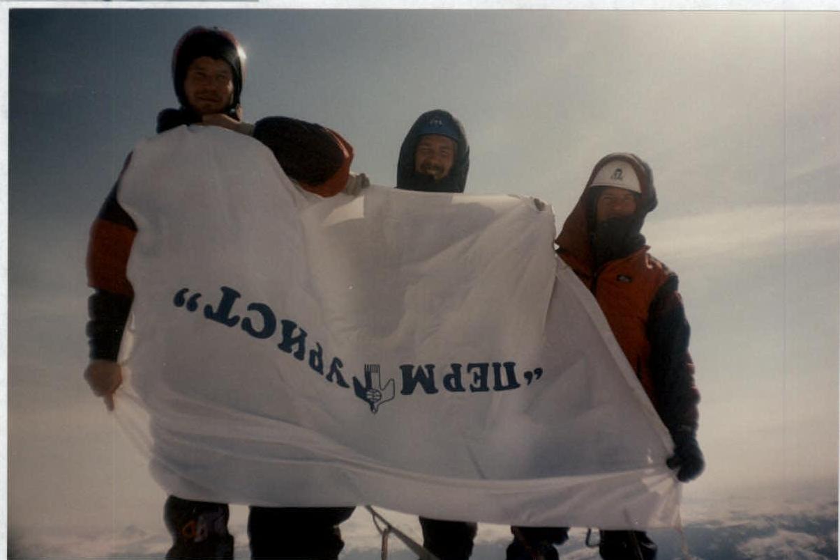
Photo #12. April 19. Group on the summit. From left to right:
- V. Malafeev
- V. Puchnin
- Yu. Zaitsev
Upon reaching the summit, the group did not find a note. There is a pole about 1.5 m high on the summit, with a cut plastic bottle attached to it, containing a chocolate bar at the time the group reached the summit of Sablya. The group left their note for the next climbers from the St. Petersburg team. An additional landmark to identify the summit in low visibility — a compass located on the N ridge approximately 1.5–2 m before the summit.
Team captain Puchnin V. E.