Peak 1309 (Polar Peak)
Route: via the southern ridge
Complexity category
Leader: Babkin V. V.
Polar Ural, Raiiz mountain massif
Section in KMGV — 8.3.
E-mail — ZHUR58@RAMBLER.RU
Report
On the first ascent of the climbing route to peak 1309 (Polar Peak) via the route: "Via the southern ridge" approximately 2A category of complexity (Combined) at the annual climbing event "Cup of NP 'Club of Northern Travels 'Sauk-Pai'" 2015 (Fourth stage. Class "First ascents").
Region: Ural Federal District of the Russian Federation (UFD), Yamalo-Nenets Autonomous Okrug of Tyumen Oblast. Mountain country: Polar Ural. Gorge: Valley of the Sob River. Ridge: Raiiz mountain massif, northwestern cirque. Peak: 1309 (Polar Peak). Route: via the southern ridge (combined). Category of complexity: approximately 2A category of complexity (combined).
Prepared by:
- Babkin V. V.
- Zhuravlev S. V. July 2015

PASSPORT
- Section number according to KMGV — 2010 — 8.3.
Polar Ural, Raiiz mountain massif (northwestern cirque), Sob River valley.
- Name of the peak: 1309.0 (Polar Peak)
Height: 1309.0
- Route: via the southern ridge.
- Category of complexity: proposed 2A category of complexity.
- Character of the route — combined.
- Height difference of the route: 509 m
- Length of the route: 1050 m
- Length of sections of the highest category of complexity:
1 cat. — 3 sections — 500 m, 2 cat. — 2 sections — 270 m, 3 cat. — 3 sections — 80 m, 4 cat. — 0 sections — 5 m, 5 cat. — 0 sections — 0 m, 6 cat. — 0 sections — 0 m.
- Average steepness: main part of the route — 35°, key section — 60°.
10. Hooks used:
Total used on the route:
- Rock hooks — 2
- Placements — 16
- Stationary pitons — 0
- ITO — 0
- Removable pitons — 0
Hooks left on the route: total — 0; including pitons — 0.
- Exit to the route — 6:00, July 3, 2015
Exit to the summit — 14:00, July 3, 2015. Return to BL — 16:00, July 3, 2015 g.
- Team's walking hours: — 10 h.
- Leader:
Babkin V. V. (Yekaterinburg, CMS, instructor-methodologist 3rd category). Participants:
- R. Sheshukov (3rd sports category, Ukhta)
- A. Radushkevich (3rd sports category, Ukhta)
- K. Tolstikov (3rd sports category, Syktyvkar)
- D. Nuzhna (3rd sports category, Syktyvkar).
- Coach: Zhuravlev Sergey Vasilievich (Syktyvkar, CMS, instructor-methodologist 1st
category)
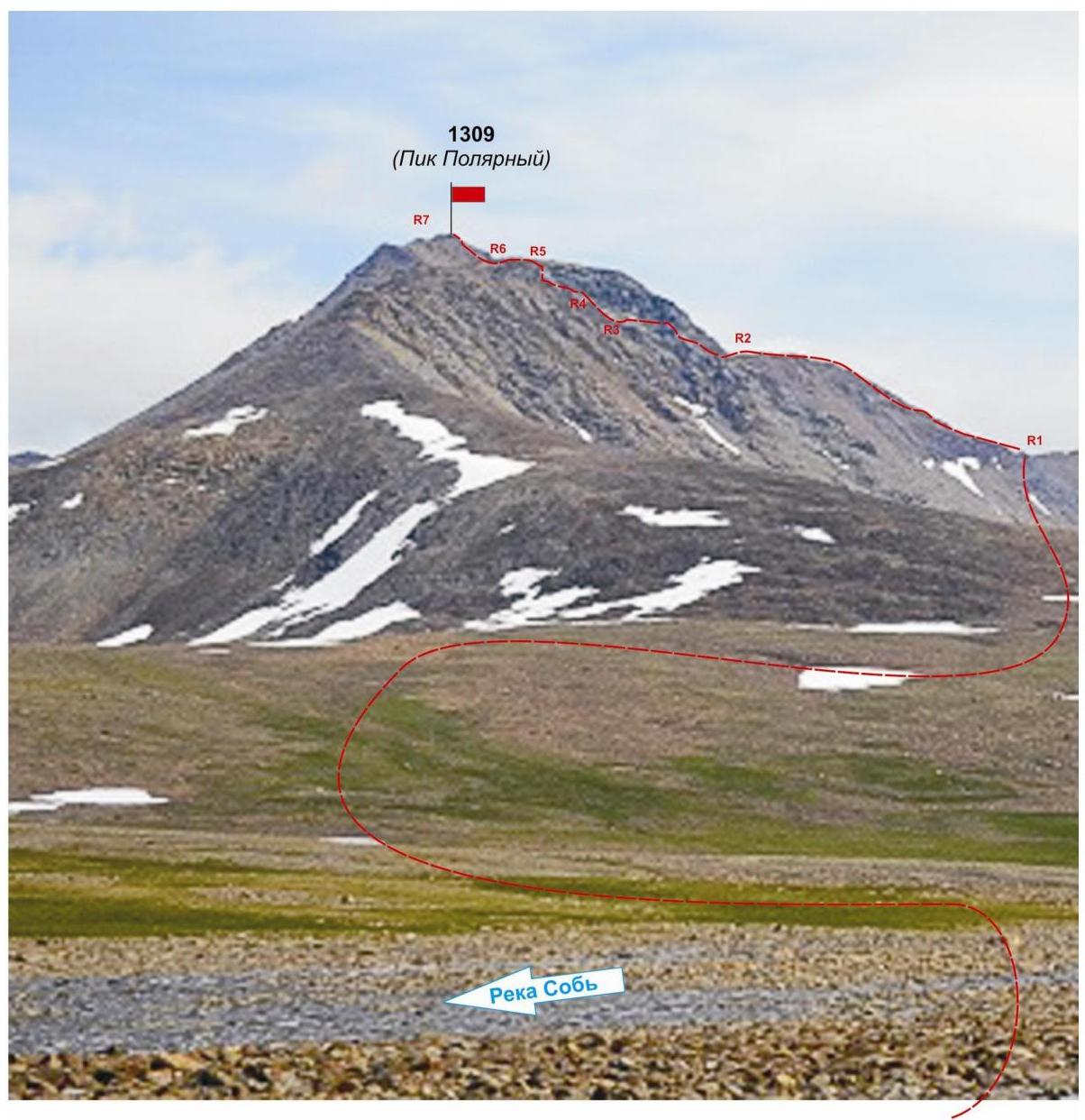
Polar Ural. Raiiz mountain massif. Northwestern cirque. Peak: 1309 m (Polar Peak). Route: "Via the southern ridge". Approximately: 2A category of complexity (Combined). Technical photo with route outline. July 2017.
Description of the peak
Peak 1309 (Polar Peak) — one of the peaks of the Raiiz mountain massif, located in the Yamalo-Nenets National Okrug (YANAO) of Tyumen Oblast, Ural Federal District of the Russian Federation, on the eastern slopes of the Polar Ural, in the northwest of the Raiiz mountain massif, on the watershed of the mountain valleys of the rivers:
- Nyrdvomen-Shor (north),
- Sob (west),
- Enga-Yu (southeast).
Peak 1309 (Polar Peak) — a pronounced pyramid. Height — 1309.0 m. The name is unofficial but has become established in the tourist-climbing community, allowing the peak to be identified as an object of sports ascents.
The following routes are classified to peak 1309 m (Polar Peak):
- "Via the southeastern ridge — 1B category of complexity (combined)".
- "Via the western ridge" — 2A category of complexity (ice climbing).
- "Via the northeastern ridge — 2A category of complexity (combined)".
The development of climbing resources continues. As part of the Cup of NP "Club of Northern Travels 'Sauk-Pai'" in 2015, route ascents were made:
- Via the southern couloir of the western ridge and the western ridge — 1B category of complexity (combined).
- Via the southern ridge — 2A category of complexity (combined).
- Via the northern edge — 3A category of complexity (rock climbing).
Description of the route: "via the southern ridge 2A category of complexity (combined)".
Route: (via the southern ridge 2A category of complexity (combined)) — a characteristic training route of the second category of complexity, with a full range of natural obstacles. Passing this route has not only aesthetic but also practical training significance, as it allows for the development of insurance and self-insurance techniques on rock and snow terrain within the ascent.
The route is ridge-like, allowing for safe training ascents in winter and summer.
Equipment
To complete the ascent as part of a training group of 6 people (5 participants + instructor), the following special equipment is required on the route:
Personal (mandatory):
- Tab
- Crampons
- Ice axe
Public:
- Main rope 10 mm — 3×50 m
- Rock hammer — 1 pc.
- Rock hooks — 6 pcs.
- Ice axe — 1 pc.
- Placement elements — 6 pcs.
- Extensions — 6 pcs.
- Loops — 8 pcs.
Approach
From the Polar Ural station of the northern railway, along the Sob River valley — in winter on skis, in summer through mountain tundra — the approach to the cirque formed by the western ridge of peak 1309 (Polar Peak), the general rocky ridge to the east, and the western ridge of peak 1287 (Topographers Peak) takes about three hours.
It should be noted:
- The presence of a complex wading crossing through the upper reaches of the Sob River.
- In case of high water level, the crossing should be organized at a convenient location significantly above the entrance to the northwestern cirque.
- After crossing, return along the scree and snow-covered slopes of Mount Enga-Yu-Iz (Northern).
The base camp can be conveniently set up near the lake (height mark of the water's edge is 667.0) on the scree fields of the mountain tundra. (Cooking food on a primus stove, gas).
In the cirque, strong winds are possible, so it is recommended:
- to protect tents with stone (in winter, snow) walls.
From the lake, located on the line of the foot of the mountain, the route begins.
Technical part
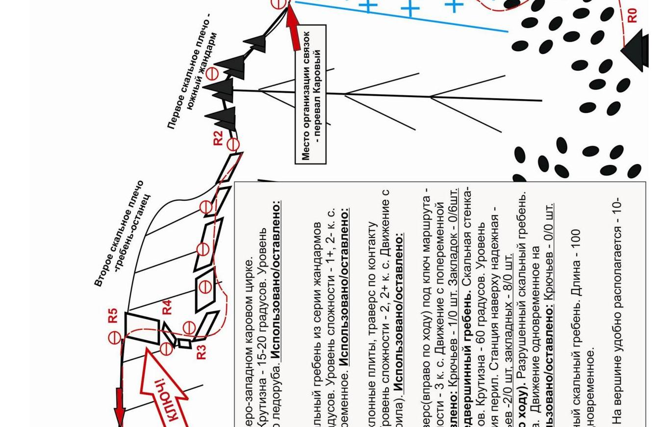
From the tongue, first along the scree, then along the snowy couloir, ascend to the Karovyy Pass. The pass is a convenient place to organize links. Before starting to move, organize links.
The rocky part of the route begins with the ascent to the first rocky shoulder of the southern ridge. The shoulder is a series of destroyed rocky gendarmes of yellow and light-brown color. They are overcome head-on. Movement does not cause great difficulties in organization and finding the path of ascent, as there is a variety of relief — ledges and steps, cracks and crevices.
After exiting to the first rocky shoulder, the ridge abuts against complex rocks of the ridge-like rocky remnant. To the right of the path (on the western slope of the mountain) are dry, dense, inclined slabs. Move in traverse, holding to the line of contact between the wall and the slabs. Convenient places for stations are located at the intersection of rocky counterforts descending from the ridge and the conditional line of contact between the wall and the slabs. There are always convenient platforms.
Traverse to the point under the pronounced vertical green stripe in the ridge. In this place, the ridge "sags" and its steepness decreases. The exit to the pre-summit ridge from the western rocky slope is the key to the route.
Key section of the route
The key section of the route is the "Green Wall", located in the upper part of the route before exiting to the pre-summit ridge. The wall is composed of dense rocky formations of pronounced green color (nephrite serpentine), clearly standing out against the lighter yellow-brown rocks of the mountain. The rocks of the wall are smoothed, but this is the most reliable and safe path to the summit. There is sufficient relief for organizing intermediate insurance points. At the exit, there is a convenient station on a large rocky block.
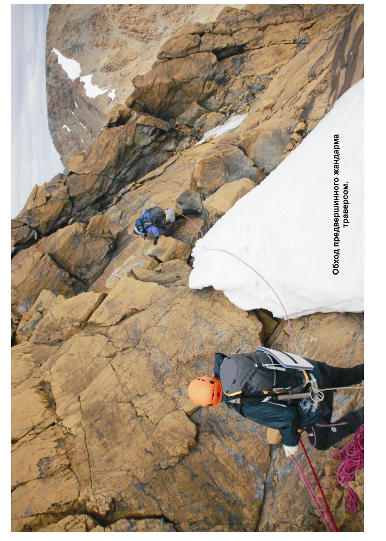
After passing the key section — the "Green Wall" — movement continues along the jagged ridge, bypassing a large pre-summit gendarme to the right of the path, in traverse along rocks of medium complexity, with an exit to the scree of the summit dome.
Summit
Pronounced, with a tur clearly in the center of large stone blocks, marked with a wooden pole.
Descent from the summit
Along the western ridge and the southern couloir of the western ridge (route 1B category of complexity).
Polar Ural. Raiiz mountain massif. Northwestern cirque. Peak: 1309 m (Polar Peak). Route: "via the southern ridge". Category of complexity: approximately — 2A category of complexity. Character of the route: combined.
(table of natural obstacles on the route)
| Section | Length | Steepness | Character of relief | Cat. sl. | Number of hooks/placements |
|---|---|---|---|---|---|
| APPROACH | From the base camp in the upper reaches of the Sob River to the foot of the couloir 30 minutes along mountain tundra, scree, snow. | Photo №1, 2 | |||
| R0 — scree at the second mountain lake of the northwestern cirque. | Entrance to the couloir leading to the Karovyy Pass. | ||||
| R0–R1 Ascent along the snowy slope to the Karovyy Pass. | 300 | 20 | Snow. | n/k, 1- | Used 0/0 Left 0/0 Photo №3 |
| R1 — Karovyy Pass | Place for organizing links | ||||
| R1–R2 Ascent to the first rocky shoulder along a series of yellow gendarmes. | 300 | 15- 30 | Destroyed rocks. Large rocky blocks of yellow, light-brown color. Movement is simultaneous, on a shortened rope, in some areas with alternating insurance. | 1, 2- | Used 0/0 Left 0/0 Photo №4 |
| R2–R3 Traverse of the rocky massif "Ridge-remnant" along inclined slabs. | 150 | 40 | Dense, smoothed slabs. Traverse with alternating insurance, in some areas — organization of railings. Stations are conveniently organized on the ridges of rocky counterforts descending from the "Ridge-remnant". | 3- | Used 0/10 Left 0/0 Photo №5 |
| R3–R4 Approach to the KEY. Short rocky wall-monolith and complex traverse to the right under the "Green Wall". | 30 | 60 50 | Rocky wall — 5 m. Slab (traverse) — 12 m | 3 3 | Used 1/6 Left 0/0 Photo №7 |
| R4–R5. Ascent to the pre-summit ridge. KEY! "Green Wall" | 50 | 60 | Rocky wall-monolith of green rocks (nephrite serpentine) | 3- | Used 2/8 Left 0/0 Photo №7 |
| R5–R6 Ascent along the destroyed rocky ridge, bypassing the pre-summit gendarme (to the right) | 120 | 20 | Rocky ridge of large rocky blocks. | 2 | Used 0/0 Left 0/0 |
| R6–R7 Ascent to the summit along | 100 | 15–20 | Rocks-monolith, inner corner. | 1, n/k | Used 0/0 Left |
| medium-block scree. | 0 / 0 | ||||
| R7 — v. 1309 (n. Polar Peak) | Pyramid-shaped, pronounced, tur in the center, marked with a wooden pole. | Photo №8 | |||
| DESCENT | Along the western ridge and the southern couloir of the western ridge (route 1B category of complexity) |
Total
Length of the route — 1050 m. Average steepness — 35°. Character of relief — combined.
Technical sections:
- 1 cat. — 3 sections — 500 m
- 2 cat. — 2 sections — 270 m
- 3 cat. — 3 sections — 80 m
- 4 cat. — 0 sections — 5 m
- 5 cat. — 0 sections — 0 m
- 6 cat. — 0 sections — 0 m
Hooks and placements used: 2(16) pcs. Hooks and placements left: 0(0) pcs.
R0. Start of the route. Medium-block scree at the second sub-glacial lake in the northwestern cirque.
R0–R1. Ascent to the Karovyy Pass along the snowy couloir.
- Length — 300 m.
- Steepness — 15–20°.
- Level of complexity — N/K, 1 cat.
- Movement is simultaneous, with self-insurance using an ice axe.
- Used(left): Hooks — 0(0) pcs, placements — 0(0) pcs.
R1. Karovyy Pass. Place for organizing links.
R1–R2. Ascent to the first rocky shoulder of the southern ridge. Destroyed rocky ridge from a series of gendarmes of yellow, light-brown color.
- Length — 300 m.
- Steepness — 15–30°.
- Level of complexity — 1+, 2- cat.
- Movement is simultaneous, on a shortened rope, in some places — alternating.
- Used(left): Hooks — 0/0 pcs, placements — 0/0 pcs.
R2–R3. Traverse of the rocky massif "Ridge-remnant". Dense rocks, inclined slabs, traverse along the contact between the wall and the slabs.
- Length — 150 m.
- Steepness — 40°.
- Level of complexity — 2, 2+ cat.
- Movement with alternating insurance, in some areas — interaction of links (railings).
- Used/left: Hooks — 0/0 pcs, placements — 0/10 pcs.
R3–R4. Approach to the KEY. Wall of dense monolithic rocks, complex traverse (to the right) under the "Green Wall".
- Length — 17 m.
- Steepness — 45–50°.
- Level of complexity — 3 cat.
- Movement with alternating insurance. Interaction of links (organization of railings).
- Used/left: Hooks — 1/0 pcs, placements — 0/6 pcs.
R4–R5. Passage of the key section "Green Wall" and exit to the pre-summit ridge. Rocky wall-monolith of green color.
- Length — 50 m.
- Steepness — 60°.
- Level of complexity — 3-, 3+ cat.
- Movement with a leader. Interaction of links. Organization of railings.
- Station at the top is reliable — a large stone block. Platform is convenient.
- Used/left: Hooks — 2/0 pcs, placements — 8/0 pcs.
R5–R6. Passage of the pre-summit ridge. Bypassing the gendarme (to the right).
- Movement is simultaneous on a shortened rope.
- Insurance for ledges and large stone blocks.
- Used (left): Hooks — 0/0 pcs, placements — 0/0 pcs.
R6–R7. Ascent to the summit dome along medium-block scree.
- Length — 100 m.
- Steepness — 15–20°.
- Level of complexity — N/K, 1 cat.
- Movement is simultaneous.
- Used/left: Hooks — 0/0 pcs, placements — 0/0 pcs.
R7 — peak 1309 (Polar Peak). The summit is pronounced. Tur in the center. Convenient for 10–12 people.
Polar Ural. Raiiz mountain massif. Peak: 1309 (Polar Peak). Route: "Via the southern ridge". Approximately: 2A category of complexity (Rock climbing).
Photo: Ascent to the Karovyy Pass along the snowy couloir from the Sob River valley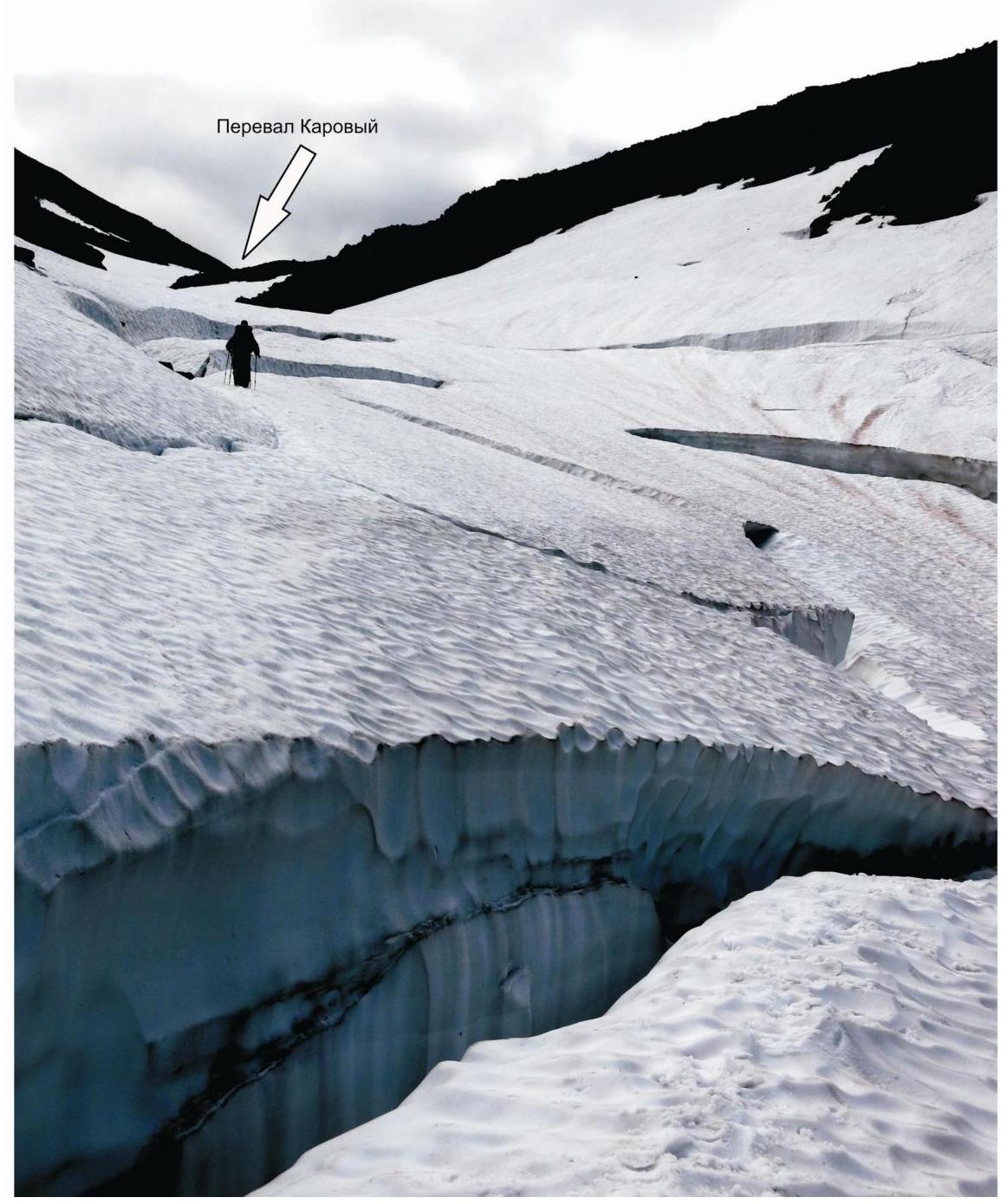
Polar Ural. Raiiz mountain massif. Peak: 1309 (Polar Peak). Route: "Via the southern ridge". Approximately: 2A category of complexity (Rock climbing).
Photo: key section of the route — "Green Wall"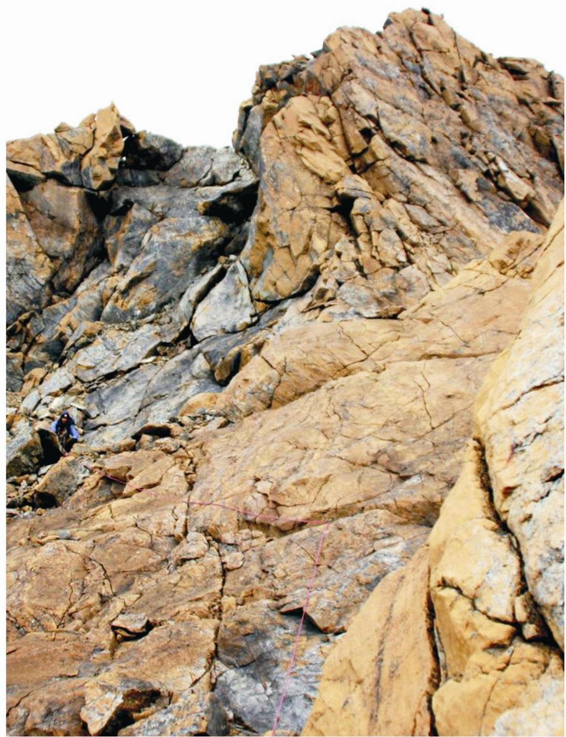
Bypassing the pre-summit gendarme