Ascent Passport
-
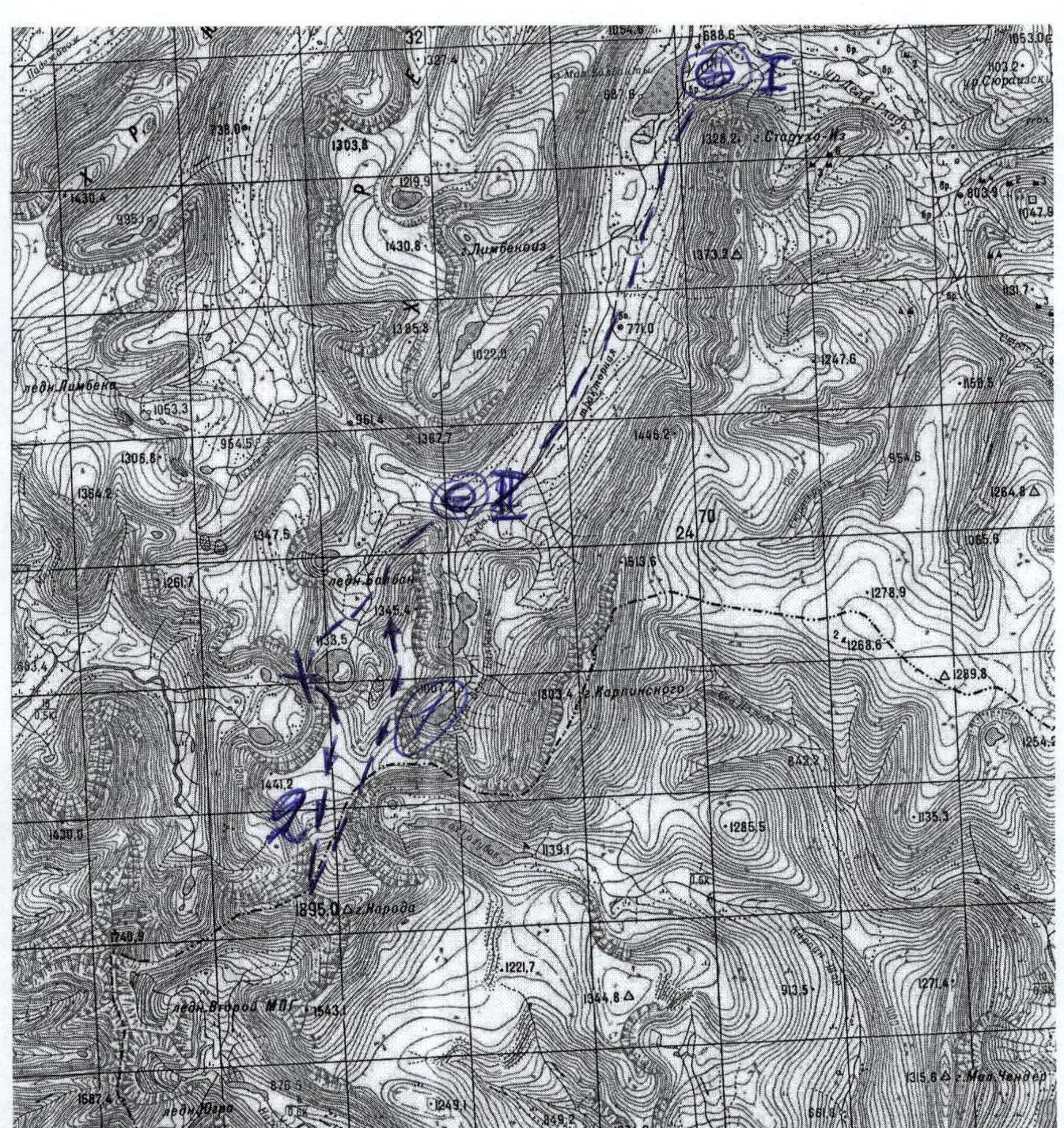
Region, valley, section number according to KMGV 1.1. Region — Subpolar Urals. 1.2. Ridge — Issledovatorsky Ridge. 1.3. Valley — River valley Balbanyu. 1.4. Section number according to KMGV–2001 — 8. "Other mountain systems, massifs".
-
Name of the peak, height, route name 2.1. Name of the peak — Mt. Narodnaya 2.2. Height — 1895 m 2.3. Route name — via the northern ridge from the Balbanyu river valley
-
Proposed category of complexity (variant, combination) 3.1. Proposed 1B category.
-
Route characteristics 4.1. Combined
-
Height difference, route length, length of sections with 5, 6 categories of difficulty, average steepness of the main part of the route, entire route 5.1. Height difference — 1420 m 5.2. Route length — 2700 m 5.3. Sections with 5 — none, 6 — none 5.4. Average steepness of the main (technical part) of the route — 45°. 5.5. Average steepness of the entire route — 50°.
-
Pitons left on the route, including bolted ones, used on the route: rock, stoppers, bolted stationary, bolted removable. NTO 6.1. No pitons left on the route. 6.2. Pitons were not used.
-
Team's travel hours 7.1. Approach to the "Behind the all-terrain vehicle" bivouac — 1 day. 7.2. Ascent from the "Behind the all-terrain vehicle" bivouac — 14 hours.
-
Leader — Full name, sports rank, title, participants 8.1. Polyakov Sergey Nikolaevich, 1st sports rank, instructor 2nd category. 8.2. Participants: P. Gayner — 3rd sports rank (Syktyvkar), I. Ivonina — 3rd sports rank (Syktyvkar), V. Toropov — 3rd sports rank (Syktyvkar), A. Shershov — 3rd sports rank (Syktyvkar). 8.3. Note: We ask the classification commission of the FAR not to include the group in the KMGV as pioneers. This route is a classic ascent path to Mt. Narodnaya, the sports group only classified this route to match the KMGV requirements.
-
Coach, Full name, title, instructor qualification 9.1. Zhuravlev Sergey Vasilyevich, Candidate Master of Sports, instructor 2nd category.
-
Exit to the route: hours, day, month, year. Exit to the summit, return to the base camp 10.1. Exit to the route — 8:00, July 22, 2005. 10.2. Exit to the summit — 14:00, July 22, 2005. 10.3. Return to the base camp — 18:00, July 22, 2005.
-
Organization 11.1. Youth Alpine Scientific-Sports Expedition of the Alpinism Federation of the Komi Republic and the "Yugyd va" National Park — "Victory–2005", from July 15 to August 2, 2005.
Exec. Zhuravlev Sergey Vasilyevich. Syktyvkar, 167000, Internatsionalnaya st., 97, apt. 12. Phone 24-24-91. E-mail: Zhur58@rambler.ru

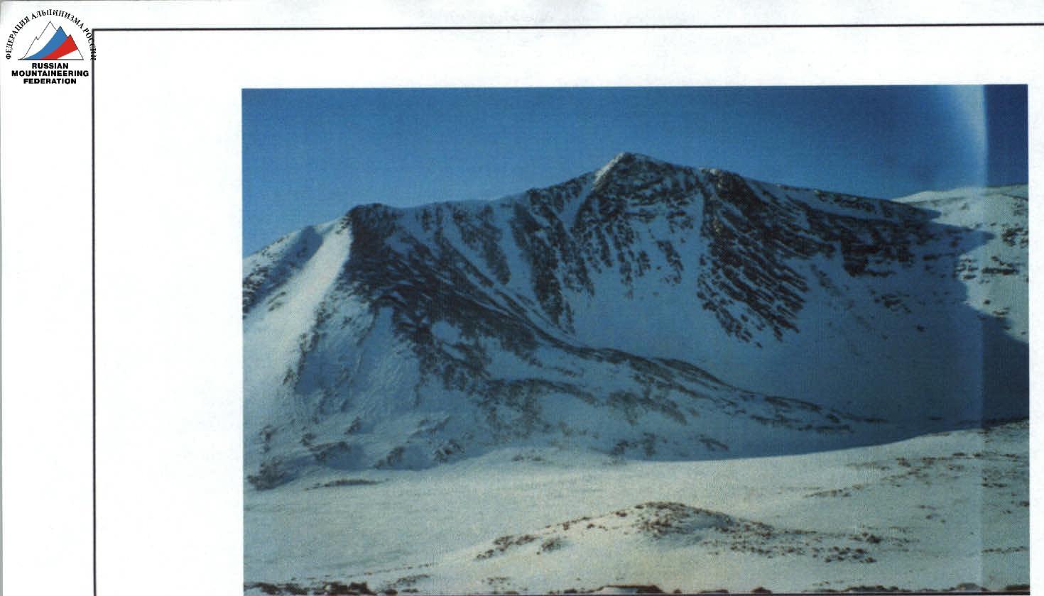
Peak "Narodnaya" (?) (1895)
Route: via the Northern Ridge — 1B category.
View from Mt. Barkova. (To the left is the peak — Pik Karpinsky)
 www.alpfederation.ru↗
Alpine Route Passport
Peak "Narodnaya" (1895) via the Northern Ridge 1B category. PSK "Subpolar Urals". PSP "Balbanyu River Valley".
| 1 | Administrative district of the Russian Federation | North-Western |
|---|---|---|
| 2 | Subject of the Russian Federation | Komi Republic |
| 3 | Administrative region | Inta |
| 4 | Natural sports complex (PSK) | "Subpolar Urals" |
| 5 | Natural sports training ground (PSP) | "Balbanyu River Valley" |
| 6 | Mountain ridge | Issledovatorsky Ridge |
| 7 | Mountain spur | Mountain horseshoe: v. Chyornaya — v. Erkusei — v. Starik — v. Starukha — p. Severny — p. Karpinsky — v. Narodnaya — v. Limbe-iz. |
| 8 | Mountain massifs within this PSP | 1. Issledovatorsky Ridge. 2. Narodo-Itinsky Ridge. 3. Maldy-Nyrd Ridge. |
| 9 | Peak (object of sports ascent) | Peak Narodnaya. Height above sea level — 1895 m. |
| 10 | Route (object of sports passage) | Northern Ridge |
| 11 | Time to complete the route | 8–10 hours from the base camp under the Limbe Pass |
| 12 | Category of difficulty | 1B |
| 13 | Analogues of the route: | 1. Kaydzhany M. (North Ossetia, Kaydzhany tract). 2. Peak Nikolaev (North Ossetia, Tsey Valley). |
| 14 | Route features | Meets the requirements of a combined route of 1B category. |
| 15 | Recommendations | The route is promising for climbers NP-1, NP-2, performing certified ascents for the "Alpinist of Russia" badge, as well as for training groups performing standards for the 1st junior rank in mountaineering. During the ascent, it is possible to learn interaction between teams on various types of mountain relief, both when moving up and when moving down. |
| 16 | Route passed and classified | This is the "classic" ascent path to Mt. Narodnaya, the highest peak in the Urals. Proposed by the FAR for classification without specifying the group of pioneers. The expert group consisting of: S. Zhuravlev (Syktyvkar, CMS, instructor 2nd category), Polyakov S. N. (Syktyvkar, 1st sports rank, instructor 2nd category), Shulepov G. G. (Syktyvkar, 1st sports rank, instructor 3rd category), Eremkin M. A. (2nd sports rank, instructor 3rd category) believe that the route meets the requirements. |
| 17 | Required additions: Protected territories, Transport, Communication, Organization of search and rescue operations | Mt. Narodnaya is located on the protected territory of the "Yugyd va" National Park of federal subordination. The most convenient way to transport workers and participants of the VUSL (outdoor training and sports camp) or VUTS (outdoor training and sports gathering) is by car from the city of Inta. Organization of communication within the VUSL or VUTS is convenient using VHF radios. For communication with the city of Inta in case of necessity, there is a constantly operating radio station based on the geologists' base "Zhelannaya", which is located 3–4 hours from the bivouac under the Limbe Pass. By the forces of the public rescue team (CO) of the alpine event. In case of necessity, it is possible to involve the PSO of the EMERCOM of Russia, based in the city of Inta. |
Notes:
- The name of the natural sports training ground is determined geographically.
- Cartography and diagrams in UIAA signs, photographic materials are attached.
- Classification of the route via the Northern Ridge to peak Narodnaya is a timely necessity, allowing the most popular route in the Subpolar Urals to be included in the unified classification of alpine routes.
Description of the peak (DSP)
Peak Narodnaya is the highest peak in the Urals — 1895 m above sea level, one of the most visited natural objects in the Komi Republic. Climbers and tourists from Russia, near and far abroad are attracted by its absolute Ural height and transport accessibility (relative to other peaks in the Subpolar and Polar Urals). It is also attractive because during the ascent, the Ural boundary between Europe and Asia is crossed. The names of the first ascenders to peak Narodnaya should be sought in the lists of geodetic expeditions of the 30s, or even earlier. The etymology of the peak's name still causes debate: whether it is named after the Siberian river Naroda, which originates on the slopes of this peak, or from the word "narod" (people). The name is well-established and marked on all maps. The alpine feature of the route is the height difference from 320 m above sea level at the foot of the mountain. Obviously, after classification of the route, the interest of Russian climbers in this peak will increase, as there will be another opportunity to fulfill normative and ranking requirements at such an attractive natural object within the framework of sports gatherings, outdoor training and sports camps, alpinadas dedicated to significant historical events.
Description of the route (DSP)
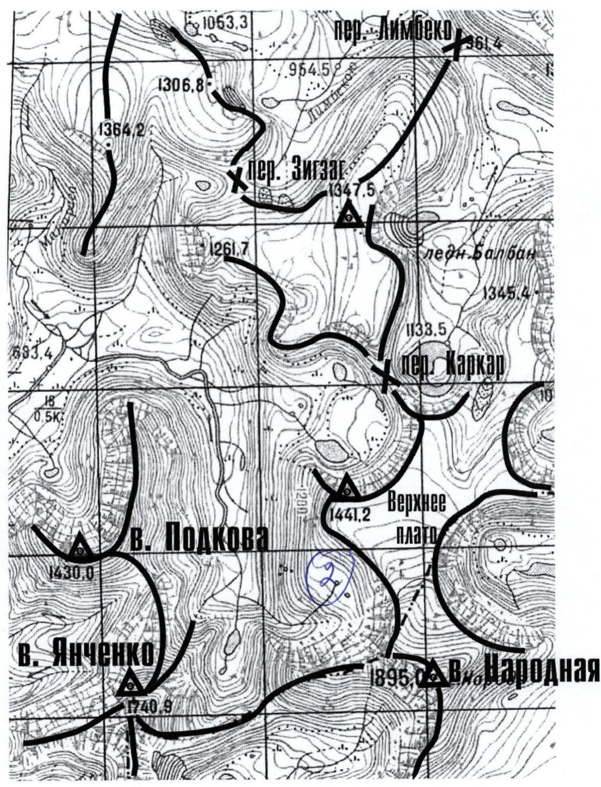
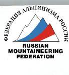
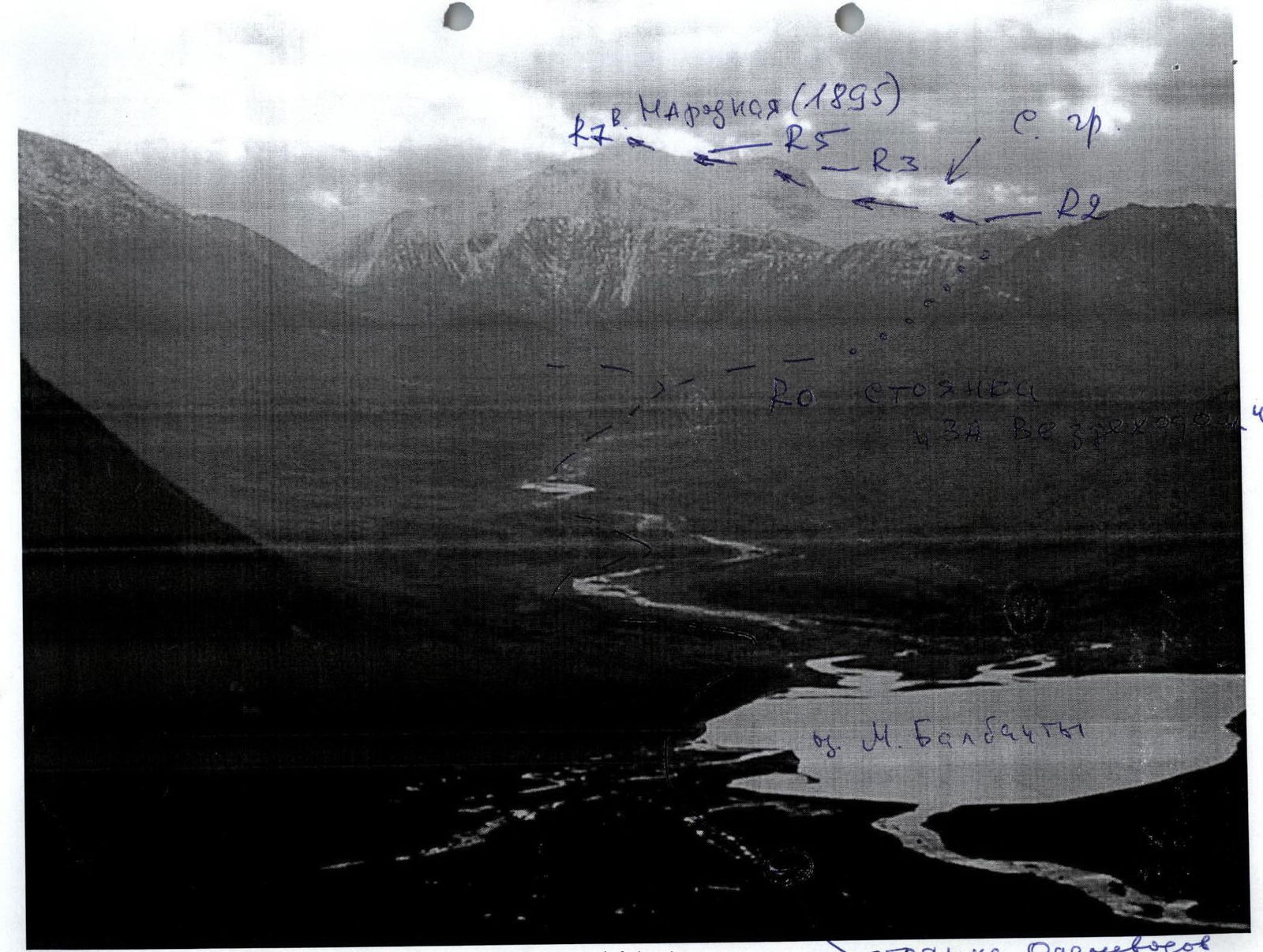
Approach: From the geologists' base — Zhelanny settlement upstream along the Balbanyu river valley on the left (in the direction of travel) bank. 3–4 hours to the reindeer herders' camp near Lake Maly Balbanty (before the camp, a ford crossing a mountain stream), approximately the same time upstream to the traditional bivouac on the slopes of peak Narodnaya under the Limbe Pass. A bright landmark on the approach is a burned-out all-terrain vehicle. Near it, one should cross the Balbanty river over rocks. Further, from the remains of the all-terrain vehicle to the traditional camps is less than 1 hour's walk. Technical part of the route: From the bivouac under the Limbe Pass, cross the stream, one of the tributaries of the Balbanty river, and begin the ascent along the right (in the direction of travel) slope of the northern ridge of peak Narodnaya. The ascent along a weakly defined mountain-tundra trail (about 1 hour) leads to the first step of the slope leading to the Kar-Kar Pass. Further, when examining the left part of the northern ridge, a wide snow-ice couloir leading to the northern ridge of peak Narodnaya is clearly visible in clear weather. The ascent along the couloir takes about 1.5 hours and leads to a wide large-block talus plateau. Along the rocks of the northern ridge, movement along the plateau to the right, towards the Kar-Kar Pass, to a noticeable flattening of the rocks. Further, not reaching the pass, along a large internal angle in the rocks on the right part, ascent to the Northern Ridge of peak Narodnaya. Then movement along the ridge to the cross. The ridge is wide. The cross is installed on the border between Europe and Asia. After the cross, a short movement along the wide ridge, then the ridge narrows and becomes rocky. The rocks are dense, 1–2 categories of difficulty. From the cross to the summit along the rocky ridge is within 1–1.5 hours for an average trained sports group. The summit is well-defined and marked by a considerable number of memorial signs of various alpine, tourist clubs and federations. Required special alpine equipment for a training and sports group of 10 people: Climbing rope — 3×30 m. Climbing pitons — 3. Station loops (descenders) — 3. Ice axes — 10. Climbing carabiners (communal) — 5. Crampons — 2 pairs. Stove (gas burner) with a pot — 1.
Tactical scheme of the route
R0–R1 Crossing the stream and ascent to the first step of the slope leading to the Kar-Kar Pass. R1–R2 Ascent along the snow-ice couloir to the northern ridge (1000 m. Snow, ice. 1–2). R2–R3 Traversing rocks and movement along the upper plateau to the internal angle. 1500 m. No category. R3–R4 Wide internal angle (in mountaineering, such angles are often called "books"). 300 m. Rocks 1–2 categories of difficulty. Movement along the talus slope composed of large blocks. Rocks 1. R4–R5 Exit and movement along the Northern Ridge to the cross. 500 m no category. R5–R6 Exit to the pre-summit rocky ridge. 500 m no category. R6–R7 Movement along the rocky ridge to the summit. 700 m. Rocks 1–2 categories of difficulty. R7 Summit Narodnaya R7–R0 Descent along the ascent route.
Exec. Zhuravlev S. V., Polyakov S. N.
Northern ridge of peak Narodnaya from the side of Goluboe Lake (winter)
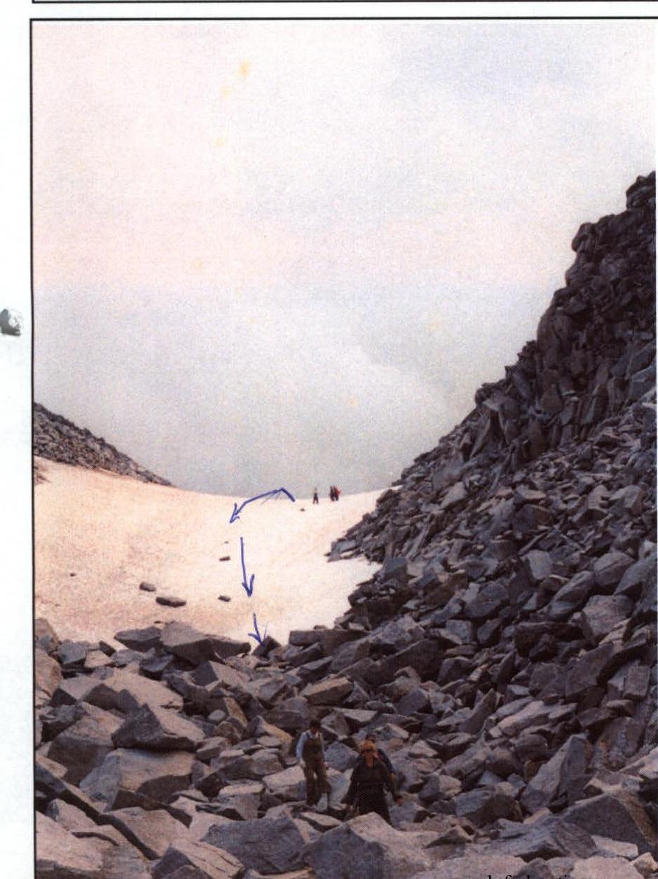
Upper part of the snow-ice couloir of the Northern Ridge, leading to the plateau of peak Narodnaya