Ascent Passport
- Region — Subpolar Urals
- Ridge — Research Ridge
- Gorge — Mountain horseshoe of Olenevodov Plateau
- Section number according to KMGV-2001 — 8. "Other mountain systems, massifs"
- Name of the peak — 1729 (p. Komsomola Main)
- Height: 1729
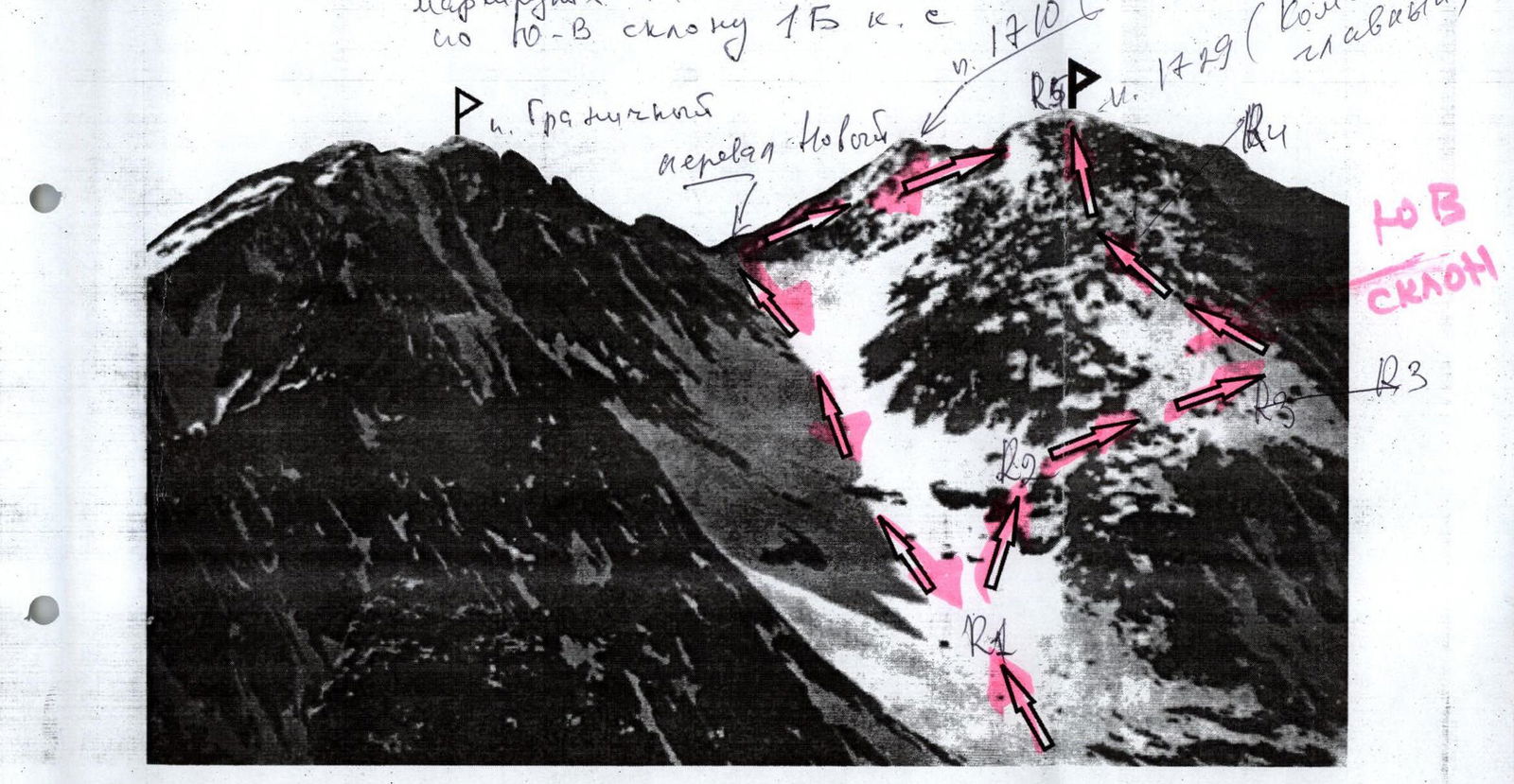
- Route name — via the south-eastern slope
- Category of difficulty — 1B category of difficulty
- Route character — Combined
- Height difference — 1150 m
- Route length: 2500 m
- Sections of 5th category of difficulty — none
- Sections of 6th category of difficulty — none
- Average steepness of the main (technical part) of the route: 55°
- Average steepness of the entire route: 55°
- No pitons left on the route:
- Pitons used: none
Team's travel hours:
- From the "Manaraga" bivouac to the "Polyakovskie nochi" bivouac: 18 h
- Ascent from the "Polyakovskie nochi" bivouac: 5 h
Leader: Polyakov S. N., 1st sports category, instructor 2nd category.
Participants:
- Gayner P. (3rd sports category, Syktyvkar)
- Toropov V. (3rd sports category, Syktyvkar)
- Ivonina I. (3rd sports category, Syktyvkar)
Polyakov Sergey Nikolaevich, 1st sports category, instructor 2nd category.
Departure on the route — 8:00, July 10, 2005 Reaching the summit — 11:00, July 10, 2005 Return to the base camp — 16:00, July 10, 2005
Youth scientific-sports expedition of the Alpinism Federation of the Republic of Komi "Pobeda-2005", July 17 – August 2, 2005
Performed by: Gayner P. S., Ivonina I. A.
Syktyvkar 167000, Internatsionalnaya st., 97, apt. 12. Tel. 24-24-91. E-mail: Zhur58@rambler.ru
 www.alpfederation.ru↗
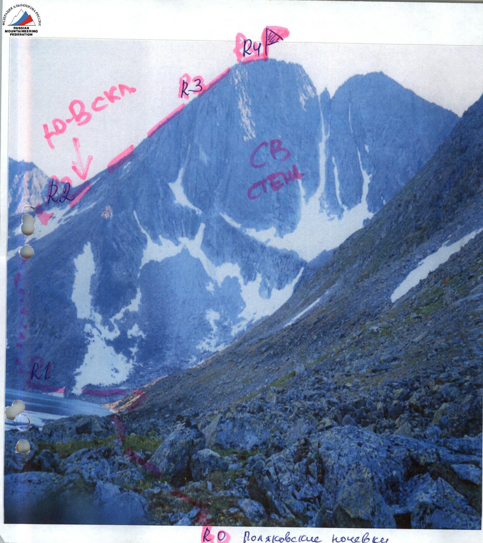
Upper part of the route to p. 1729 via the South-Eastern slope 1B category of difficulty.
Mountain horseshoe of Olenevodov Plateau (view from "Polyakovskie nochi")

- v. Bezymyannaya-1 (1675 m).
- v. Bezymyannaya-2 (1680 m).
- p. Sverdlova (?) (1711 m).
- p. Reguly (1650 m).
- v. Bezymyannaya-3 (1600 m).
- v. Bezymyannaya-4 (1661 m).
- p. Granichny (1671 m). On the photo, it is hidden by the eastern slope of p. Komsomola (?).
- p. Komsomola Main peak (1729 m).
- p. Komsomola Western peak (1695 m).
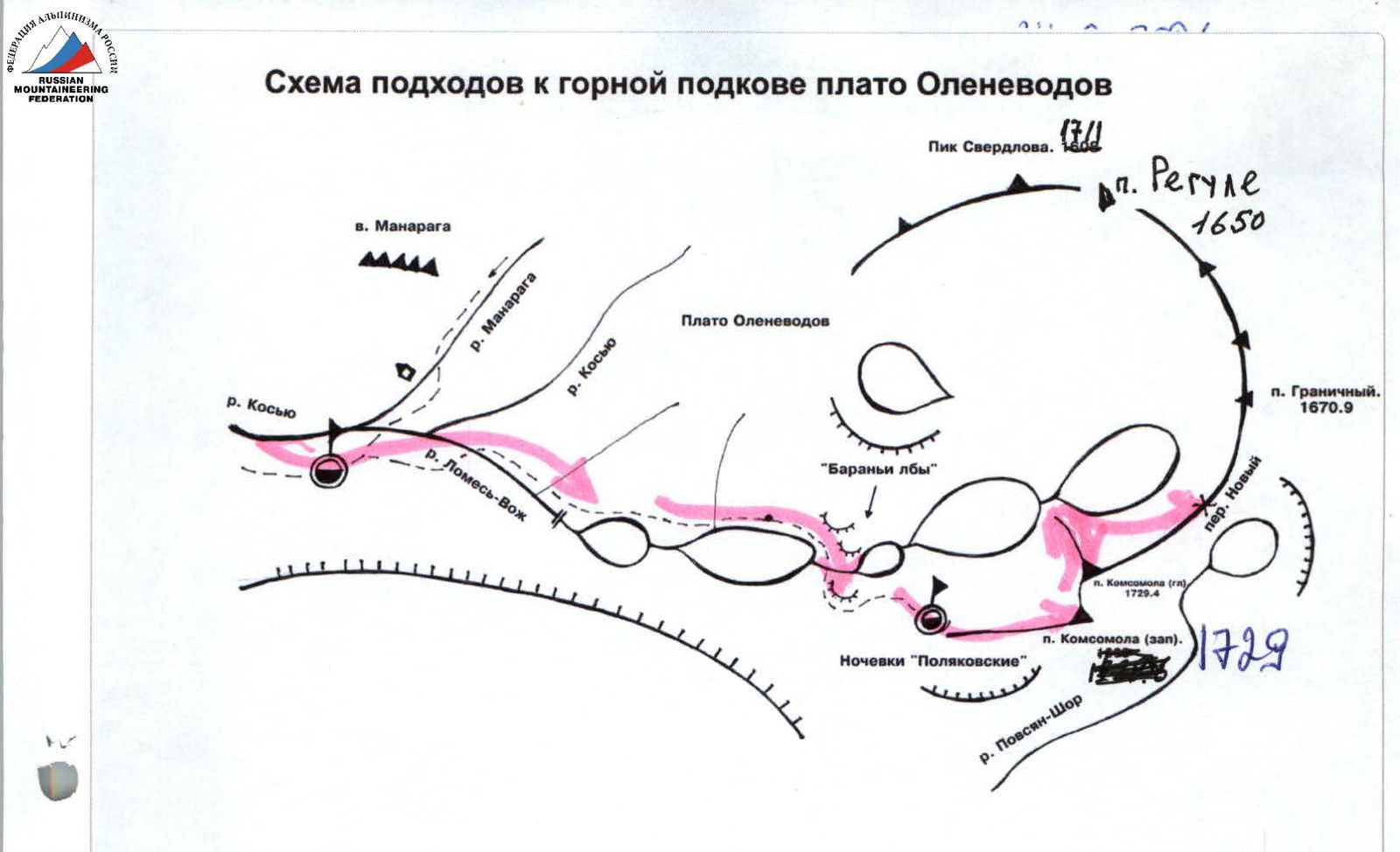
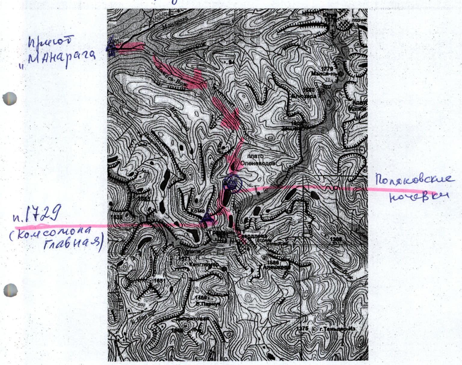
Approach route to the mountain horseshoe of Olenevodov Plateau
Scale 1 cm → 1.3 km
The height of p. Komsomola (?) is 1729 m above sea level. It is located in the Research Ridge. This is the far right peak in the mountain horseshoe of Olenevodov Plateau. Streams Lomes'-voz', Pyvsyan-shor, and Morenny (all streams are left tributaries of the Kos'yu river) originate from the slopes of p. Komsomola. When approaching via the Lomes'-voz' stream valley, the peak is easily recognizable by its characteristic appearance: two oval peaks and a gendarme in the gap between them. The classic approach route: from the mouth of the Lomes'-voz' stream and along the old geological trail to Olenevodov Plateau. Then, transition to "Polyakovskie" overnight stays under the eastern wall of p. Komsomola.
Route description (OSP)
Approach: From the base camp on the bank of the Kos'yu river, move along the Lomes'-voz' stream to Olenevodov Plateau (Old geological trail on the right bank of the Lomes'-voz' stream), then across the plateau to "Polyakovskie nochi" near the nameless lake under the eastern wall of p. Komsomola (?). An alternative approach is possible (see the approach scheme) both from the left along the way, through Olenevodov Plateau, and from the right, after crossing the stream under the cliffs limiting the plateau, along the talus slopes. During the approach, in the upper part, there are: rocky sections, large-block taluses, and "ram's foreheads" of 1–2 categories of difficulty. The approach takes 8–12 hours.
"Polyakovskie nochi" is a convenient place to set up a bivouac and survey the ascent area. p. Komsomola (?) is the first peak on the right among the peaks of the mountain horseshoe, characteristically expressed by a double peak with a large gendarme between them.
The technical part of the route begins from "Polyakovskie nochi". First, move to the right along the right (along the way) bank of the lake, bypassing the eastern wall along the taluses. Approaching the upper lake of the cirque of the mountain horseshoe, start ascending along the north-eastern slope (at times, climbing of 1st category of difficulty along large-block taluses). Closer to the pre-summit ridge, the taluses change to medium-block ones. It is convenient to use snowfields for the ascent, which by the end of summer more resemble prolonged snow islands in the slope hollows.
Steady movement to the pre-summit ridge without pronounced landmarks on the slope, with alternating movement along taluses and snowfields.
Reaching the pre-summit ridge. Simultaneous movement to the summit along rocks of 1, at times — 2 categories of difficulty. The summit is well-defined.
Recommended descent: via the ascent route. Passing the route from the base camp in the Kos'yu river valley with a return to the base camp requires at least 3 days.
Passing the technical section from the bivouac at "Polyakovskie nochi" — 6–8 hours.
Required equipment for a sports group of 4 people:
- Climbing rope 2×50 m
- Ice pitons — 2
- Stopper set — 5 (standard set)
- Rock pitons — 3
- Station loops — 5–8
- Primus (gas burner) — 1
- Poncho capes — 4
Recommendations for the coach of training, training-sports groups NP-1, 2: near "Polyakovskie nochi" on the slopes of Olenevodov Plateau, there are rocky outcrops typical for the area. These rocky outcrops allow for rock climbing training or competitions.
When approaching "Polyakovskie nochi", it is possible to conduct practical training on topics: "Crossing mountain rivers", "Movement along taluses and grassy slopes".
Specific features: In the summer, due to the polar day, there is an added resource of daylight hours.
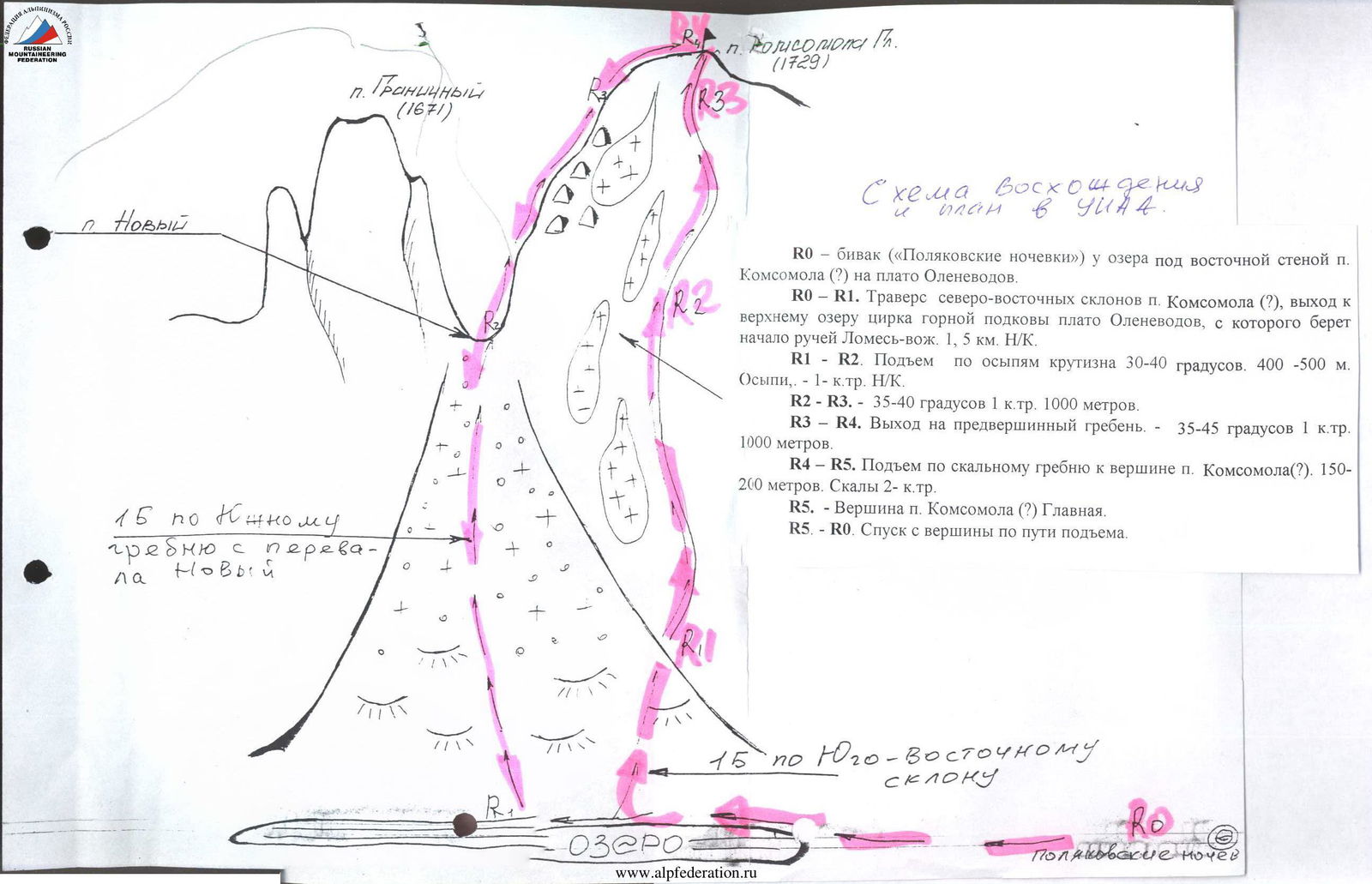
Alpinist route passport
Mountain region — Subpolar Urals Gorge — Lomes'-voz' stream valley Ridge — Research Ridge Section — mountain horseshoe of Olenevodov Plateau Peak — p. 1729 (Komsomola) Route — via the southern ridge from p. Novy Category of difficulty — 1B category of difficulty (combined)
Alpinism Federation of the Komi Republic, Syktyvkar
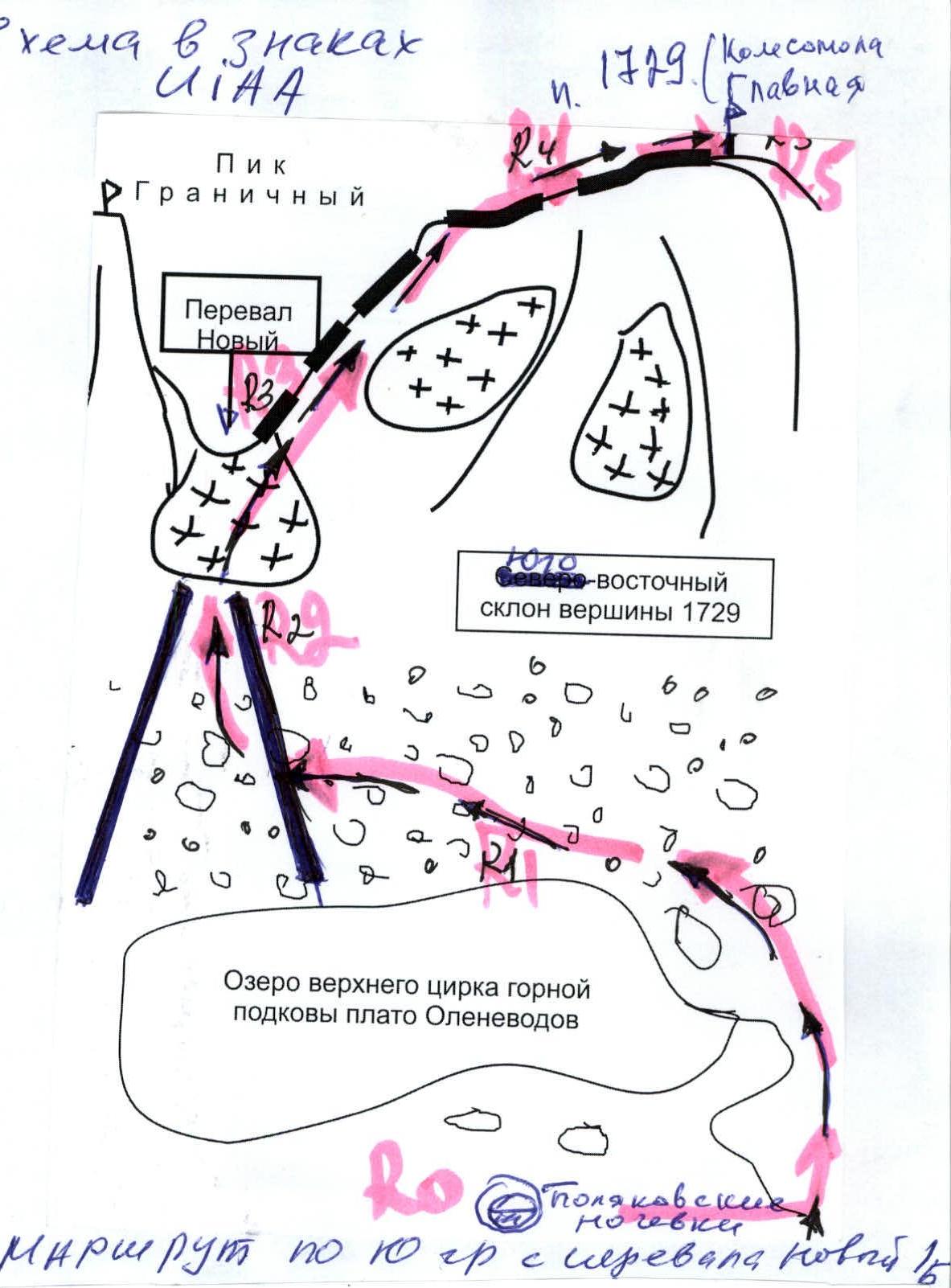
R0 — "Polyakovskie nochi" bivouac near the lake under the Northern wall of p. Komsomola (?) on Olenevodov Plateau.
R0–R1. Traverse of the north-eastern slopes of p. Komsomola (?), exit to the upper lake of the cirque of the mountain horseshoe of Olenevodov Plateau, from which the Lomes'-voz' stream originates. 1.5 km, n/c.
R1–R2. Ascent along taluses to a snow couloir. 300–500 m.
- Taluses
- n/c, 30°
R2–R3. Ascent along a snow couloir to the Novy pass. Snow — 35–40°, 1 km, 1000 m.
R3–R4. Ascent along a rocky ridge from the Novy pass to the summit of p. Komsomola (?). 300–350 m.
- Rocks 2
R5. — Summit of p. Komsomola (?) Main. R5–R0. Descent from the summit via the ascent route.