24
Mountain region — Subpolar Urals, gorge — Balbanyu river valley, peak — Mount Karpinsky (1803)
Route — via the southern ridge, diff. cat. — 2A (rock)
Alpinism Federation of the Komi Republic, 2005
View from the top of Narodnaya
Ascent passport
-
Region — Subpolar Urals. Gorge — Balbanyu river valley.
-
KMGV-2001 section number — #8. "Other mountain systems, massifs"
-
Peak name — Mount Karpinsky
-
Height — 1803 m
-
Route name — via the southern ridge from pass #23
-
Diff. cat.: 2A
-
Route type: combined
-
First ascent
-
Height difference: 1320 m
-
Route length: 2000 m
-
Sections of 5th diff. cat. — none
-
Sections of 6th diff. cat. — none
-
Average steepness of the main (technical) part of the route: 50°
-
Pitons on the route: not left behind
-
Drill-in pitons: not used
-
Team's travel hours:
- Approach to the "Za vezdehodom" bivouac from the Zhelannaya geologists' base — 12 h
- Ascent from the "Za vezdehodom" bivouac — 14 h
Participants:
- Popov Mikhail Borisovich, 2nd sports category (Syktyvkar)
- S. Prima — 3rd sports category (Inta)
- S. Kiselev — 3rd sports category (Inta)
- Yu. Mezenev (Inta)
Coach: Zhuravlev Sergey Vasilyevich, CMS, 2nd category instructor
Chronology:
- Departure on the route — 7:00, July 18, 2004
- Reaching the summit — 12:30, July 18, 2004
- Return to the base camp — 14:30, July 18, 2005
Organization: Monitoring expedition of the Alpinism Federation of the Komi Republic and the Yugyd Va National Park — "Polar Vertical – 2005", July 15 – August 2, 2005.
Executors: Zhuravlev Sergey Vasilyevich, Prima Sergey Nikolayevich. Syktyvkar, 167000, Internatsionalnaya st., 97, apt. 12. Phone: 24-24-91. E-mail: Zhur58@rambler.ru
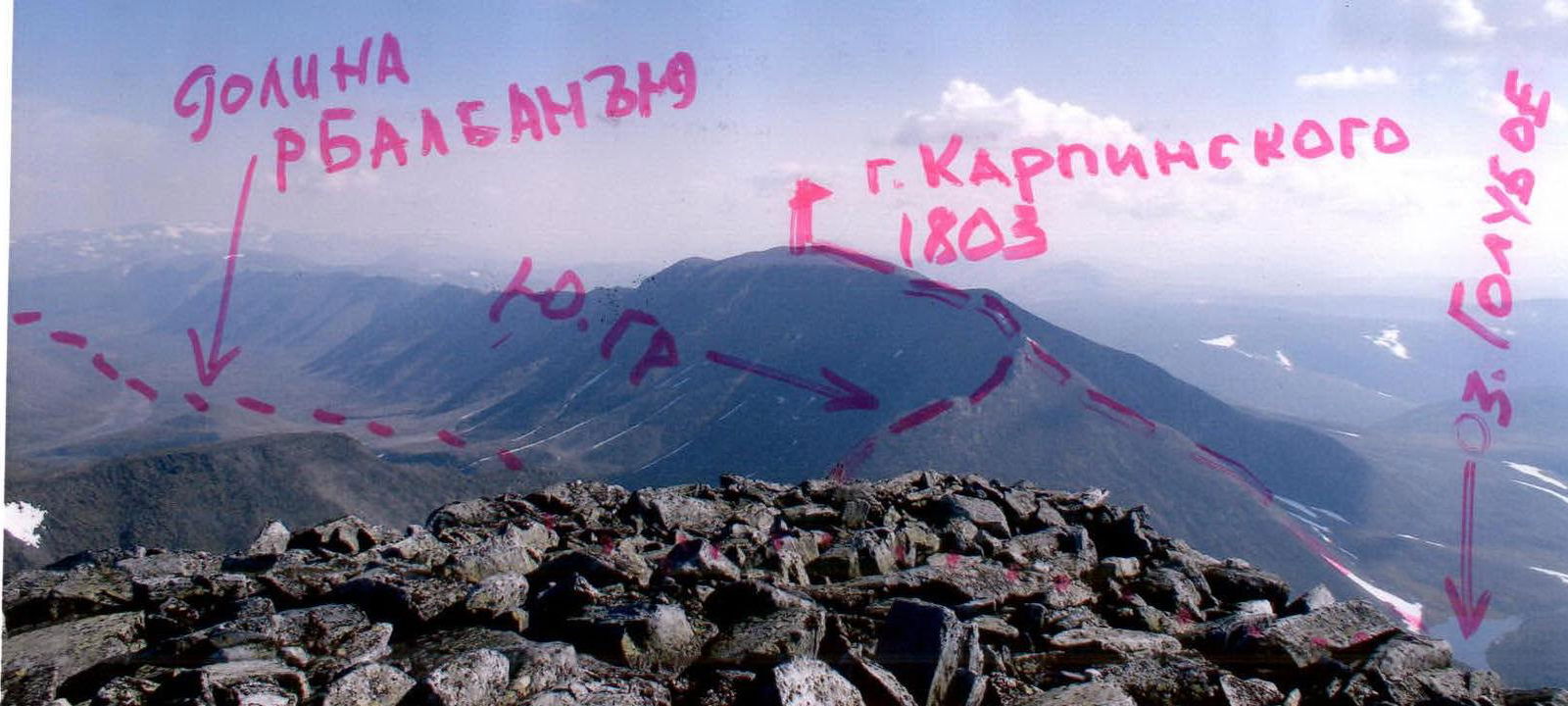
Summit — Mount Karpinsky (1803 m)
Mount Karpinsky, 1803 m above sea level, is the second highest peak in the Urals and the highest peak in the Komi Republic. It is located in the Research Ridge, on the border between Europe and Asia, between the mountain massifs of Mount Starukha (1439 m) and Mount Narodnaya (1895 m). It was discovered in 1927 and named after the first president of the USSR Academy of Sciences, A. P. Karpinsky (1847–1936).
Several routes lead to the summit of Mount Karpinsky, both from the west (from Europe) and from the east (from Asia).
A distinctive feature of all routes is their considerable length (the technical part of each route is over 2000 m). The routes are structured in a step-like manner, with short, complex rock walls alternating with lengthy ridge sections. The height difference from the base camp is over 1500 m.
Another common feature of all routes is the climate:
- From October 15 to May 25, the routes on Mount Karpinsky are combined.
- Only during the short summer season, from May 25 to October 15, are the routes rock.
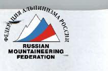
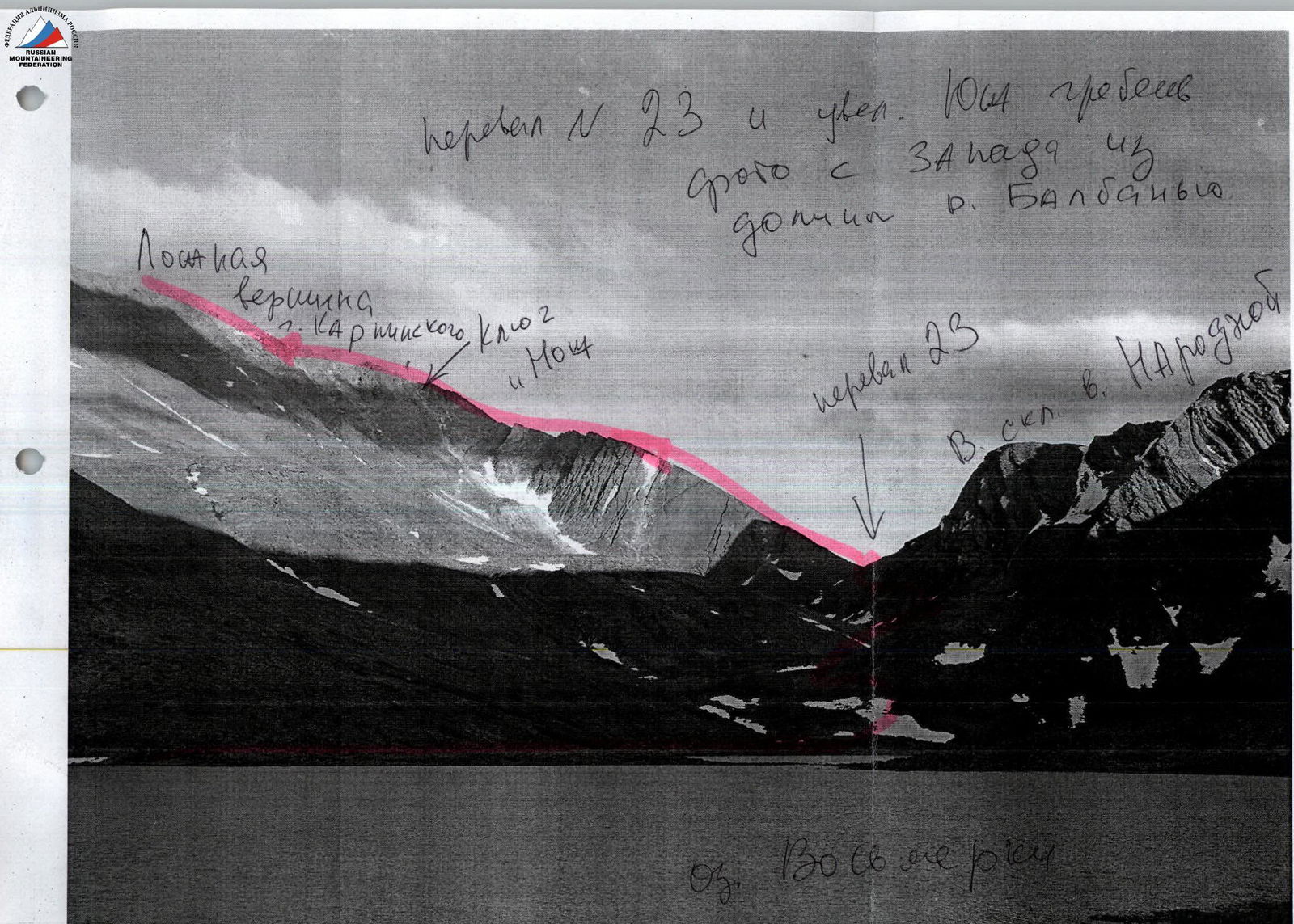
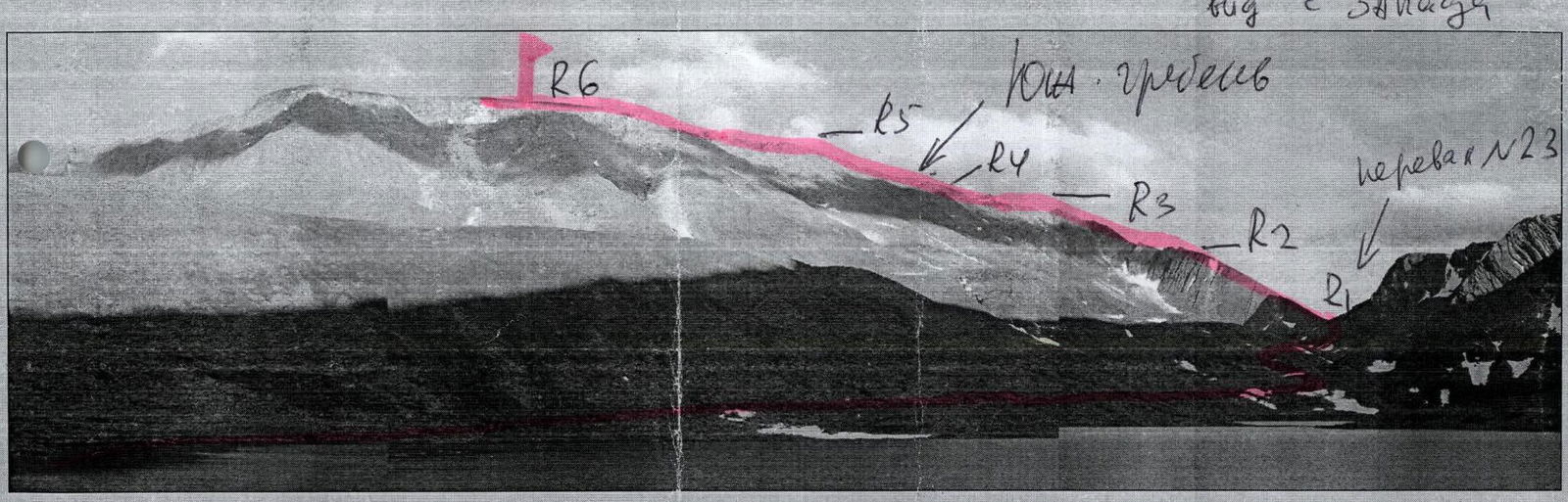
Via the Southern ridge from pass #23, 2A diff. cat. (View from the east)

Route diagram: via the S ridge from pass #23. 2A diff. cat.
R0–R1 — Ascent to pass #23.
- Large-block talus, low category
- Steepness 35–45°
- The exit to the pass point is steeper — 45–55°
- Approach to the pass from the right
R1–R2 — Ascent along talus to the rocks.
- Talus, 300 m, 45–50°, low category
R2–R3 — Ascent along the rocky ridge to the "Blade".
- Rocks, 200–300 m, 50–60°, 2nd diff. cat.
- Simultaneous movement with rope placement around ledges
R3–R4 — Passage of the "Blade" key (Rocky ridge, 100 m, 2nd diff. cat.). Insurance with chocks, pitons (medium-sized boxes are most convenient). The complexity of the "blade" traverse is 3rd diff. cat., length — 15 m.
R4–R5 — Exit to the sub-summit.
- Medium-block talus, section complexity — low category
- Transition along the plateau to the rocky ridge of the summit tower
- Medium-block talus, section complexity — low category – 1st diff. cat.
R5–R6 — Passage of the rocky ridge of the summit tower. (Rocks. Heavily destroyed ridge, 40 m, 1–2 diff. cat.).
R6 — Summit of Mount Karpinsky
- R6–R0 — descent via route 1B diff. cat. (Along the counterfort of the eastern slope from Goluboye Lake)
- Through pass #23
- Descent to the base camp.
Route diagram: Along the counterfort of the E slope from Goluboye Lake. 1B diff. cat.
R0–R1 — Ascent to pass #23.
- Grassy slopes
- Talus
- Large-block talus
Steepness 35–45°. The exit to the pass point is steeper — 50–55°. Approach to the pass from the right. Low category.
R1–R2 — Approach to the base of the counterfort. (Grassy slopes, talus, large-block talus, low category.)
R2–R3 — Ascent along the counterfort. (Large-block talus. 800 m, 45–55°. Simultaneous movement on a shortened rope. On individual sections, alternating insurance using ledges on large rock blocks. Climbing complexity — 1st diff. cat. (2nd diff. cat. on individual sections)).
R3–R4 — Exit to the sub-summit. (Talus ridge, 500 m, 45–55°, low category.)
R4–R5 — Transition along the plateau to the rocky ridge of the summit tower. (Medium-block talus. Section complexity — low category – 1st diff. cat.)
R5–R6 — Passage of the rocky ridge of the summit tower. (Rocks. Heavily destroyed ridge, 40 m, 1–2 diff. cat.)
R6 — Summit of Mount Karpinsky
- R6–R0 — descent via the ascent route.
Route description
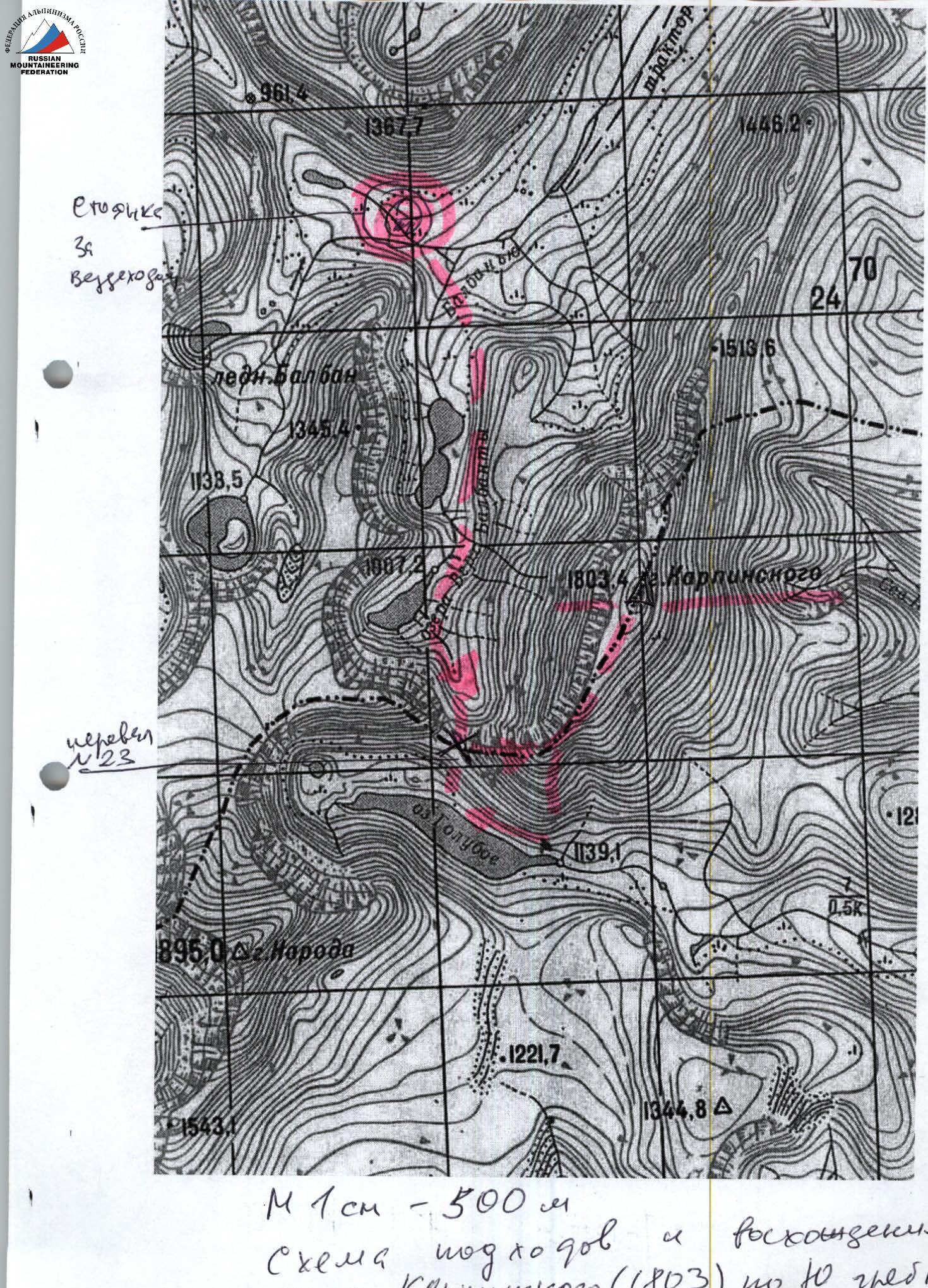
Approach: Depart from the "Za vezdehodom" campsite, cross the left tributary of the Balbanyu river, and ascend along the Balbanyu riverbed, which is composed of large stones (the river often disappears into stone depressions), to the Vosmerki lakes. Then proceed along the right bank of the lakes (on the left when moving forward) through the Balbanyu river valley to the Verkhniye Balbanyu lakes.
Then ascend to pass #23 (large-block talus, rocks 1st diff. cat., 400 m):
- ascent to the pass from the right.
Technical part: Organize teams at pass #23. Then ascend along the large-block talus to the start of the rocky ridge on the right (when moving forward) side of the southern ridge.
Then begin ascending along the rocks of 1st, 2nd diff. cat. along the ridge, staying on the right (when moving forward) side of the ridge. (Sloping rock shelves of varying steepness. Alternating insurance using ridge ledges or simultaneous movement on a shortened rope). The key section of the route is the "Blade" ridge section. It is an extremely narrow 15-meter rocky section with a small angle of ascent, but without convenient ledges or footholds. It is traversed in counter-pressure from the right side of the ridge. The complexity of this section is 3rd diff. cat.
Then again, the rocky ridge is 2nd diff. cat., and the exit is to the false summit. The false summit of the southern ridge is formed by the junction of the eastern counterfort to the southern ridge and is the boundary of the pre-summit plateau.
Then move along the pre-summit plateau — a large talus plateau (2000, low category).
Then exit to the summit rocky tower — 15 m, rocks 1st diff. cat.
Descent:
- first, via the ascent route,
- then via route 1B diff. cat. (along the rocky counterfort of the eastern slope) to Goluboye Lake.
Return to the base camp through pass #23.
Equipment for a sports group of 6 people:
- climbing rope 3x40
- pitons — 5 (preferably boxes)
- chock stones — set — 12 pcs.
- tent — 1
- stove (gas burner) — 1
- pot — 1
Instructor's notes: The route is lengthy and requires an overnight stay near pass #23 or, when returning, at Goluboye Lake. From October 25 to June 25, the route is more combined than rocky. Ice formations on the route and snow on the approach. During this period, crampons are required for all participants.
Profile of the southern ridge of Mount Karpinsky (1803 m)
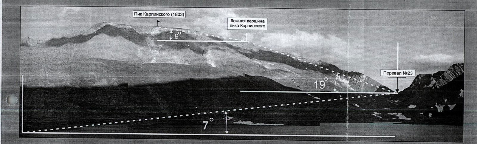
The route along the southern ridge of Mount Karpinsky from pass #23, 2A diff. cat., is a lengthy route, conditionally divided into three profile sections:
- The first — ascent from the base camp ("Za vezdehodom" campsite) along talus and mountain tundra to pass #23
- The second — transition along the southern ridge of Mount Karpinsky
- The third — descent to the settlement
The first — ascent from the base camp ("Za vezdehodom" campsite). Along talus and mountain tundra to pass #23. Average steepness 7°, when ascending to the pass — 45–50°.
The second — ascent from the pass to the jagged rocky ridge to the false summit. Average steepness 19°. On individual rocky sections — up to 60°.
The third — movement along the pre-summit plateau to the summit of Mount Karpinsky (1803 m). Average steepness 9°.