Peak Gora Barkova (1320.8) Route: via the western slope Approximate complexity category: 1Бз Leader: Goletarov A. Subpolar Urals, Rossomakha mountain range Section in CMGA — 8.3. E-mail — mr.zhur1958@mail.ru
Report
On the first ascent of the climbing route to the peak Barkova (1320.8) via the route: "Along the western slope." The complexity level is approximately 1Б category (winter) at the alpinist event "Severnaya Vertikal" (joint project of JSC "Severgaztrans" and NP "Club of Northern Travels 'Sauk-Pai'") in 2016 (Class "First Ascent").
Region: Northwestern Federal District of the Russian Federation, Komi Republic. Mountain country: Subpolar Urals. Gorge: Bolbanyu River valley. Mountain range: Rossomakha. Peak: Gora Barkova (1320.8). Route: via the western slope. Complexity category: approximately 1Бз. Route character: winter. Prepared by: A. Goletarov, Zhuravlev S. V. Date: March 2016.
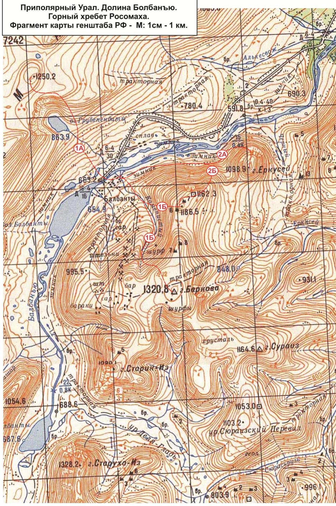
 Subpolar Urals. Bolbanyu valley. Rossomakha mountain range. Fragment of the map of the General Staff of the Russian Federation — scale: 1 cm — 1 km.
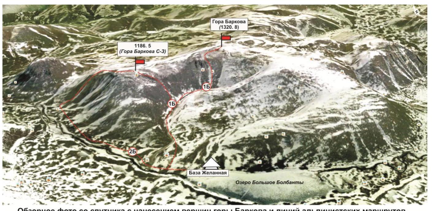
 Overview photo of Barkova mountain from a satellite for March-April 2016 with a drawing of the mastered routes (photo is not to scale).
Description of the peak
Gora Barkova is one of the peaks of the Rossomakha mountain range, located in the territory of the Municipal Formation "City District — Inta", in the Komi Republic, in the Northwestern Federal District of the Russian Federation. Geographically, it is in the central part of the Rossomakha mountain range of the Subpolar Urals, in the Bolbanyu River valley, on the right bank of Lake Bolshoy Bolbanty.
Gora Barkova is a mesa with two peaks marked on the kilometer grid map of the General Staff of the Russian Federation. The main peak of Gora Barkova is a dome-shaped elevation on a vast plateau of the mesa; the northwestern peak, which does not have an official name, is a destroyed, rubble-strewn dome, to which lead rocky buttresses from the north, northwest, and west, and on the east, a gentle slope, after a slight depression (–100 m), turns into the plateau of the main peak.
Height:
- main peak of Gora Barkova — 1320.8 m
- northwestern peak — 1186.5 m
The name of the mountain is official, given in honor of the famous Russian geographer A. S. Barkov, and is marked on the state maps of the Russian Federation.
The alpinist interest in the main peak of Gora Barkova is represented by:
- routes from the valley of the Kamienisty stream along the rocky slope of the western cirque;
- rocky buttresses leading to the northwestern peak of Gora Barkova.
As part of the "Severnaya Vertikal" alpinist event, the following routes were traversed and classified:
- Barkova Main — "Along the western slope" — approximately 1Бз (winter).
- Barkova (NW) — "Along the southwestern edge" — approximately 1Бз category (rocky).
- Barkova (NW) — "Along the 1st buttress of the northern slope" — approximately 2А category (rocky).
- Barkova (NW) — "Along the 2nd buttress of the northern slope" — approximately 2Б category (rocky).
Western slope of Gora Barkova
The western slope of Gora Barkova is a pronounced rocky slope, dissected by couloirs, located to the west of the peak, towards the Bolbanyu River valley, above the valley of its tributary — the Kamienisty stream. The average steepness of the slope is 45°. The slope is easily identifiable from the base camp (Zhelannaya base). The slope is potentially interesting for laying educational and sports routes — 1–2 categories.
Description of the route: Barkova (Main) "Along the western slope" approximately 1Бз category (winter).
Route: "Along the western slope" — a logical, winter combined route, oriented towards educational and sports groups of climbers undergoing training under Initial Training programs (NP-1, NP-2). The route allows for full development of:
- techniques of movement on snow and ice slopes,
- as well as techniques of belaying and self-belaying on snow, ice, and rocky terrain in winter conditions.
In the summer, the route is of no sporting or educational interest, as the snow cover is seasonal (from October 15 to June 15). The route is logical in orientation; the line follows a pronounced couloir.
Equipment
To complete the ascent in a sports group of 6 people, the following special equipment is required on the route: Personal — standard (crampons and ice axe are mandatory). Group equipment:
- main rope 10 mm — 2 pcs. × 50 m
- protection elements — 4 pcs.
- quickdraws — 4 pcs.
- slings — 2 pcs.
- ice screws — 2 pcs.
Approach
From the Zhelannaya base, go up the Kamienisty stream valley to the confluence of the couloirs — a weakly pronounced, central, and southwestern one.
At the confluence of the couloirs, put on harnesses and helmets, as there will be no convenient places on the steep slope.
Technical part
Then, along the left, weakly pronounced couloir (central couloir of the western slope), begin the ascent upwards towards the rocky outcrop. On the first rocky outcrop, there is a convenient place to organize the rope team. After ascending to the first rocky outcrop, the steepness of the slope increases significantly, requiring movement with alternating belays. In the upper part, it is convenient to organize belay points in the cracks of the rocky buttress (on the left), which is the boundary of the couloir. The second rocky outcrop is located below the key section of the route.
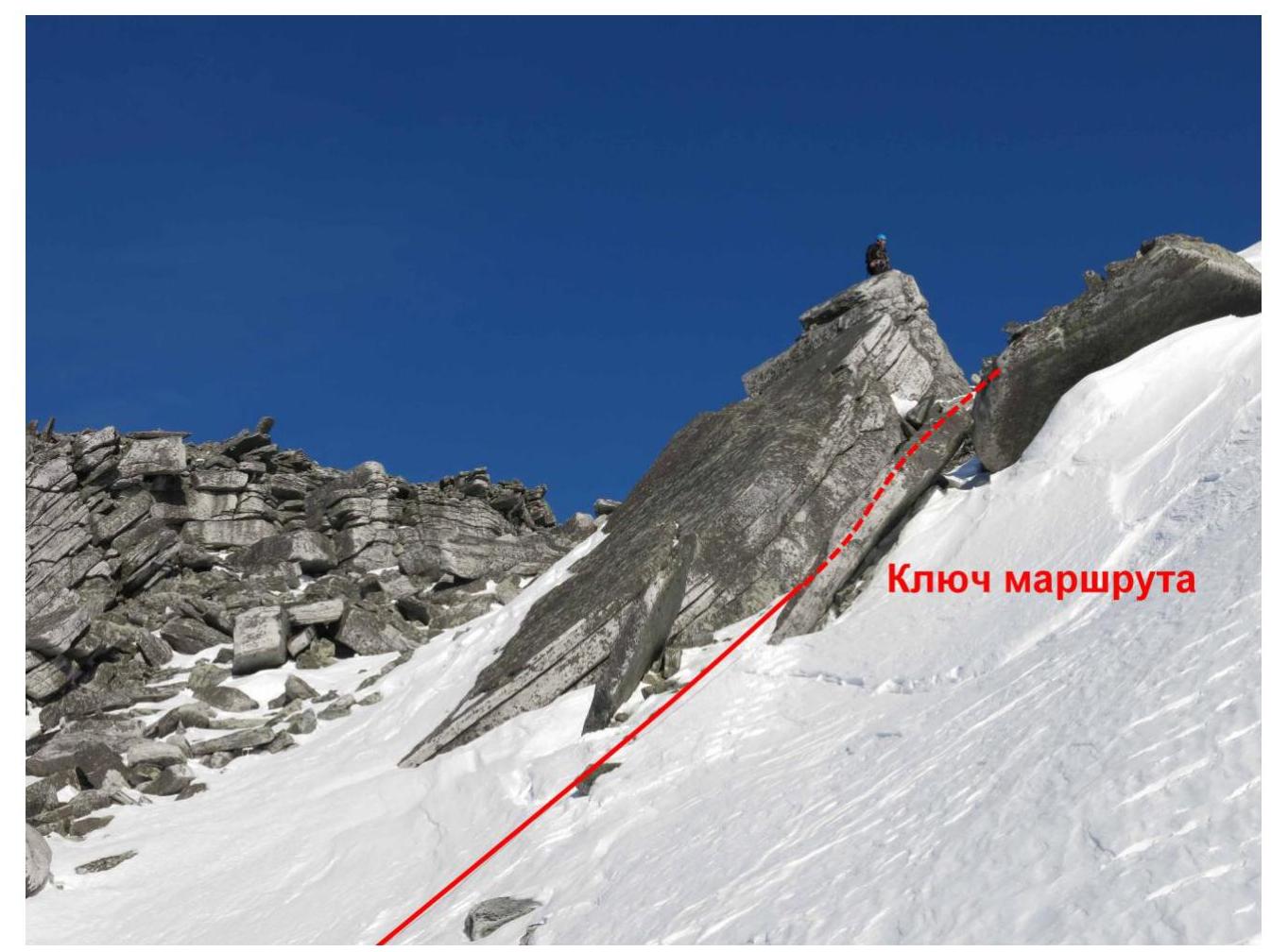
Key section: rocky belt when exiting onto the peak plateau. Passed with alternating belays and organization of fixed ropes (about 100 m).
Then, along gentle, rubble slopes, to the rocky outcrop on the dome-shaped, rubble peak with a geodetic benchmark.
Peak
The peak is a dome with large stone blocks. With a geodetic benchmark.
Descent from the peak
Along the non-categorized southwestern couloir into the Kamienisty stream valley. Then, down the valley to the Zhelannaya base.
Descent on skis or snowboards is possible along the southwestern slope. Prolonged, gentle, and avalanche-safe descent.
After the passage of this non-categorized slope by French ski-alpinists, it is called the "French trail".
Subpolar Urals. Bolbanyu valley. Peak Gora Barkova (1320.8). Route: "Along the western slope". Complexity level: 1Бз category (winter) approximately. Table of natural obstacles.
| Section № | Length (m) | Steepness | Character of terrain | Category | Number of pitons/slings (pcs.) |
|---|---|---|---|---|---|
| APPROACH | From "Zhelannaya" base along the Kamienisty stream valley to the start of the route — confluence of two couloirs — 50 min. | ||||
| R0 | Confluence of two couloirs. Convenient place for changing, organizing rope teams. | ||||
| R0–R1 Passage of the first couloir to the rocky outcrop | 400 | 15°–20° | Snow and ice couloir. Crust, firn | 1- | 0 / 0 |
| R1–R2 Passage of the second couloir. Movement along the rocky slope on the left. Belaying — stations and intermediate points on rocky terrain | 200 | 45° | Snow and ice couloir. Crust, firn | 1- | 0 / 4 |
| R2–R3 KEY! Passage of the rocky belt and exit onto the pre-peak plateau | 100 | 50° | Rocky belt. Rocks — monolith, inner angle | 2- | 2 / 2 |
| R3–R4 Passage of the pre-peak plateau and ascent to the rocky outcrop of the peak. | 200 600 | 15° | Large-block rubble slope | 1, n/k | 0 / 0 |
| R4 Peak of Gora Barkova (1320.8) | The peak is marked by a heap of large stones. Placement of the group does not cause problems | ||||
| DESCENT | Descent along the non-categorized western slope ("French trail") to the Zhelannaya base. Or along the western couloir into the Kamienisty stream valley. Further — along the Kamienisty stream valley to the Zhelannaya base. |
Total
Route length — 1500 m. Height difference — 665 m. Average steepness of the entire route — 30°, key section — 45°, at the exit — up to 55°.
Character of terrain — winter.
Technical sections:
- 1 category — 3 sections — 800 m,
- 2 category — 1 section — 100 m,
- 3 category — 3 sections — 0 m,
- 4 category — 0 sections — 0 m,
- 5 category — 0 sections — 0 m,
- 6 category — 0 sections — 0 m.
Pitons and protection used: 0/4 pcs.
Pitons and protection left: 0/0 pcs.
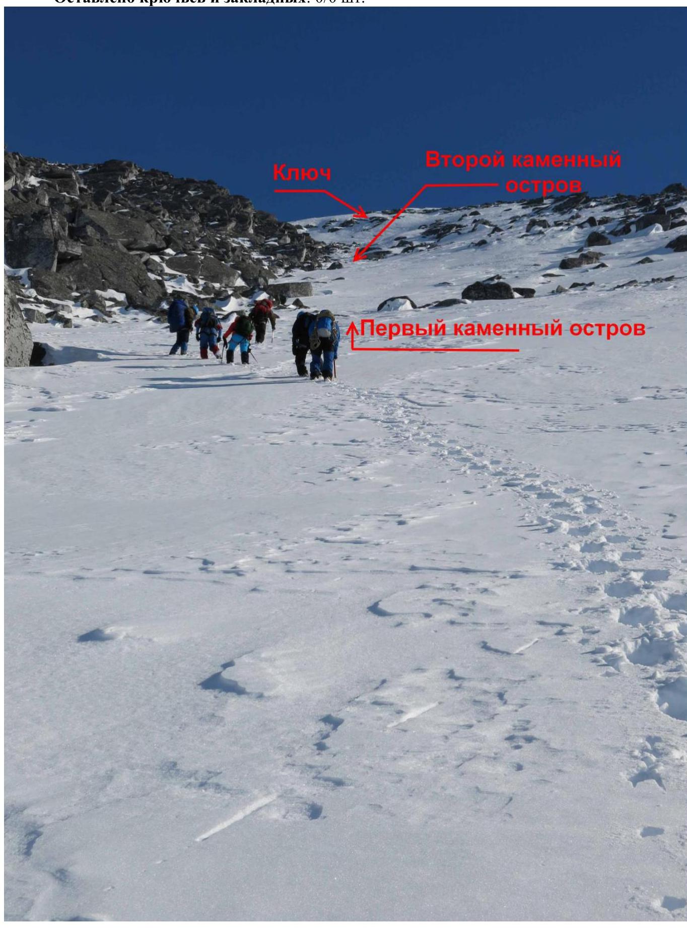 Photo №1. View of the route with main landmarks.
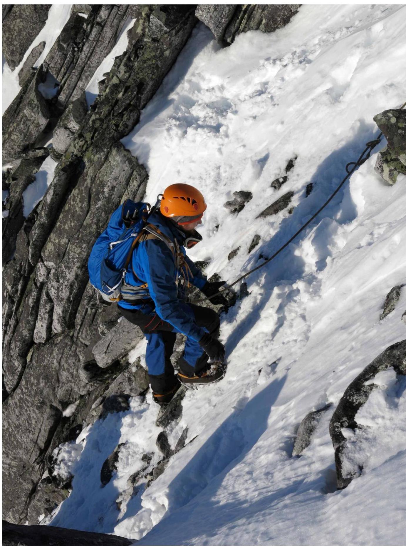 Photo №2: Passage of the couloir between rocky outcrops.
 Photo №3: Passage of the key section.
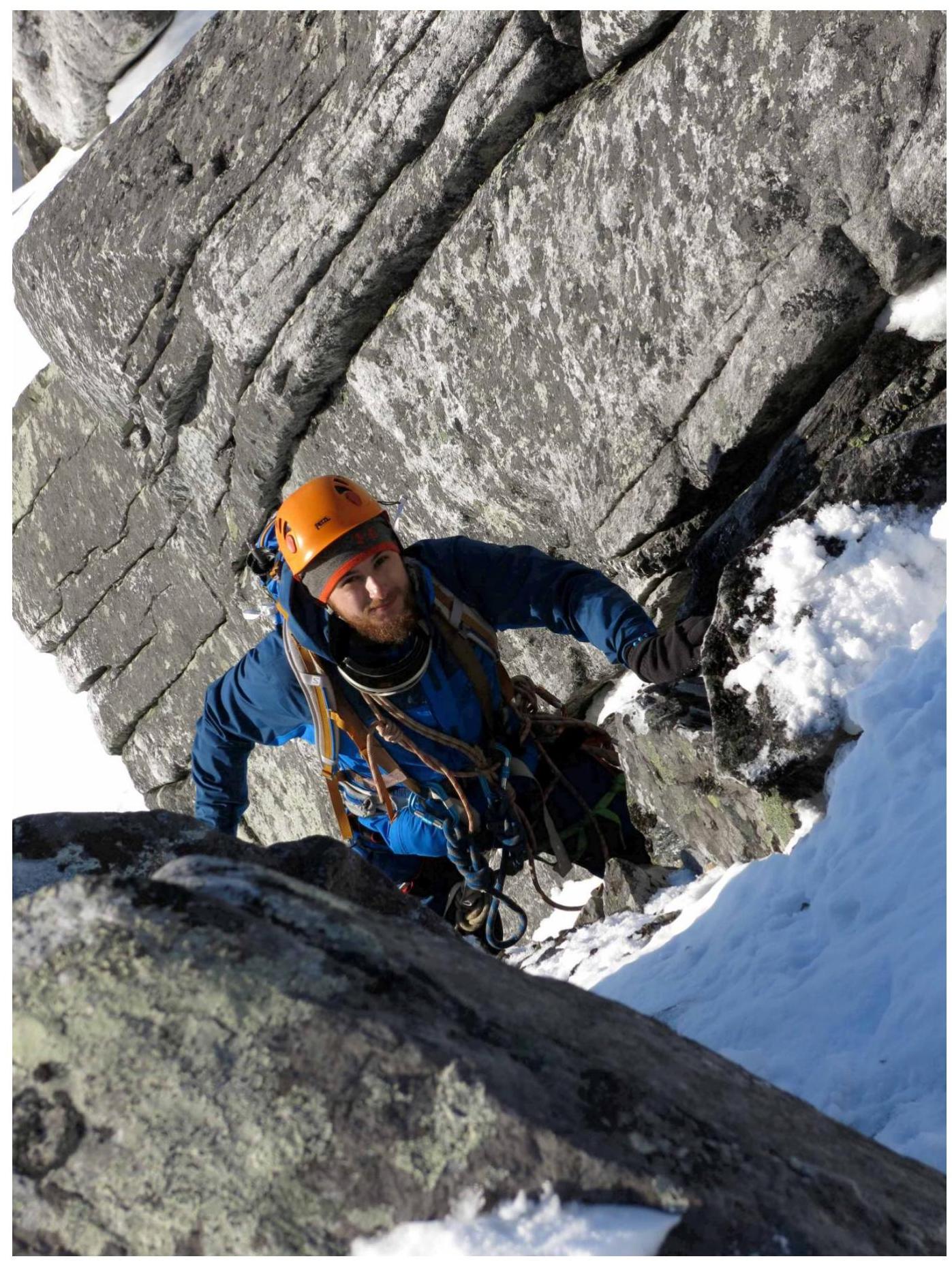 Photo №4: Passage of the upper part of the key section before exiting onto the peak plateau.
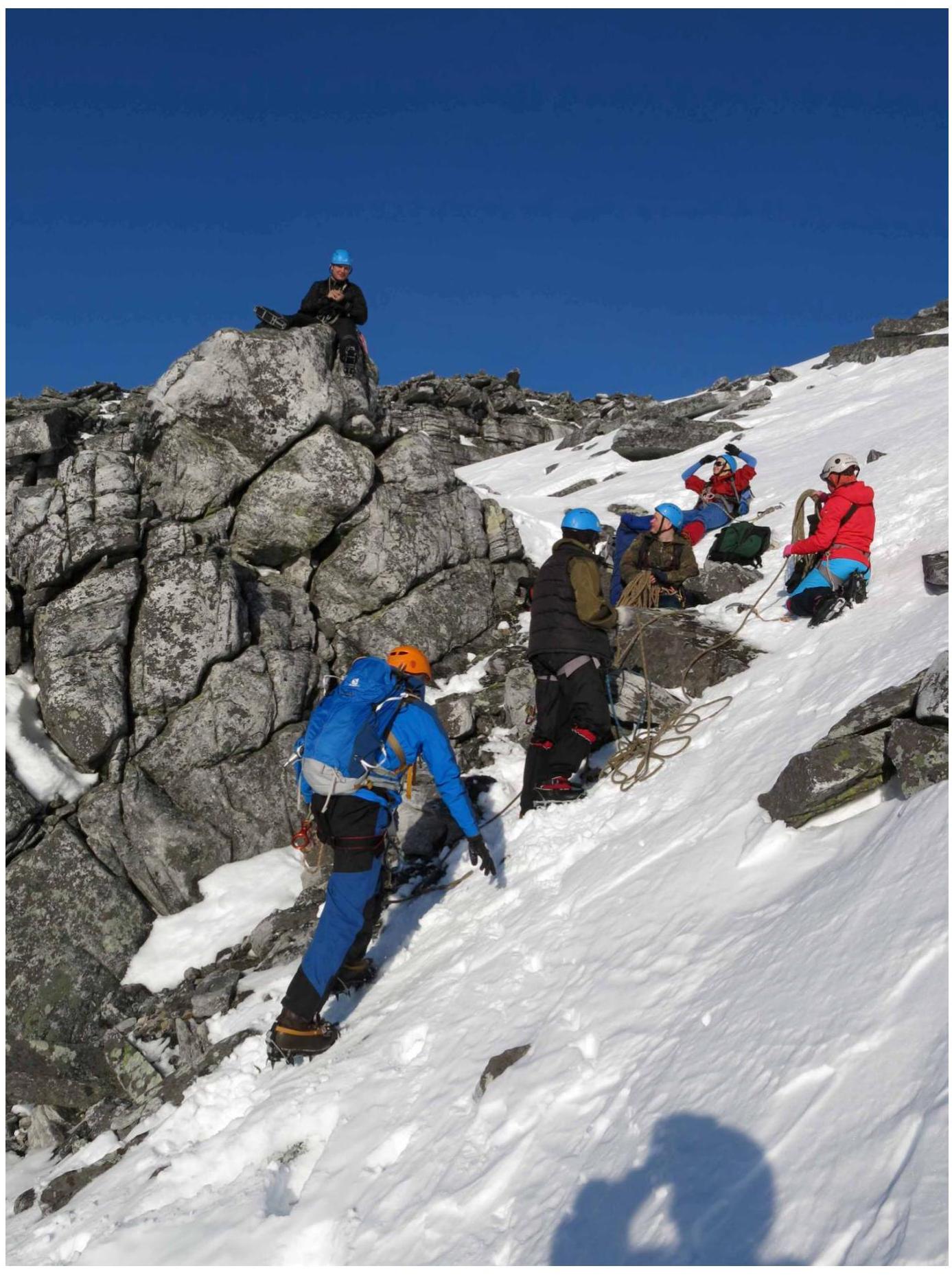 Photo №5: Station after passing the key section before exiting onto the peak plateau.
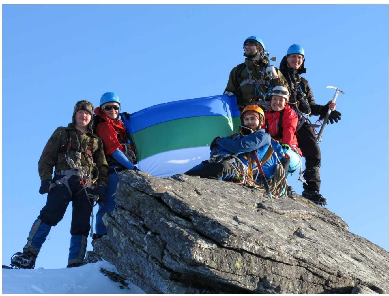 Photo №6: Peak — Gora Barkova.