
Report
Teams from Sverdlovsk Region
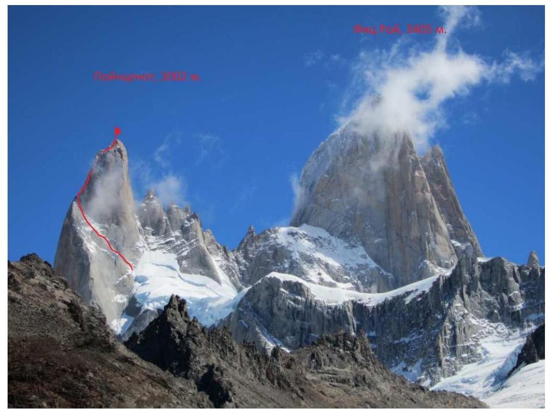
On the ice-snow "ramp" of the East wall of Poincenot peak, 3002 m (Fitz-Roy massif, Patagonia, Argentina)
February 11, 2012
Russian Championship 2012. High-altitude technical class, Yekaterinburg, 2012.
Ascent Passport
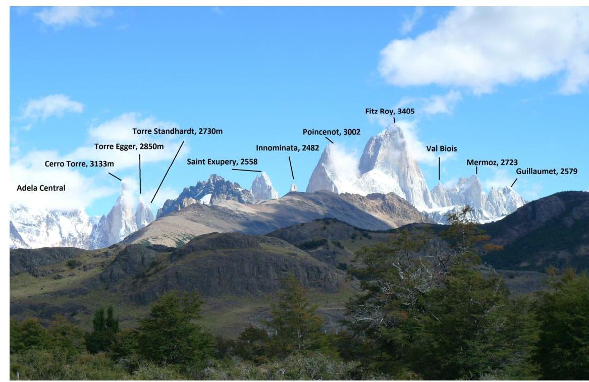
- Mountain system: Patagonia (Argentina). Valley: Fitz-Roy massif (Fitz-Roy). Peak name: Poincenot, 3002 m. (The peak is not in the classification table)
- Route name: Whillans–Cochrane via the ice-snow ramp of the East wall
- Proposed category: 5B
- Route character: combined
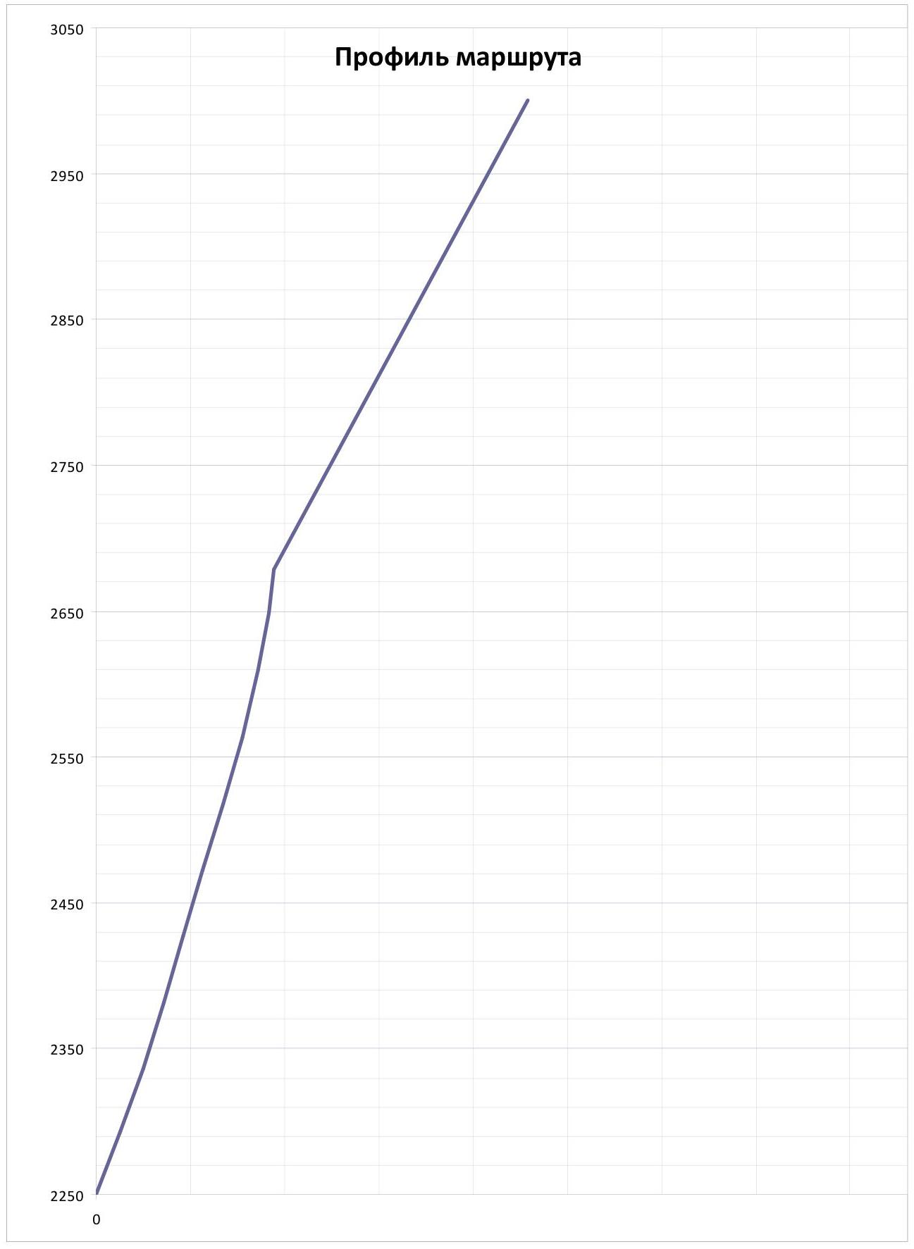
- Route characteristics: Height difference: 750 m. Route length: 890 m. Section lengths: Category V: 490 m. Category VI: 40 m. Average steepness: Main part of the route ("ramp" of the East wall): 66.3° Total route: 58.6°
- Pitons used on the route: Stationary pitons: 0 pcs. Removable pitons: 0 pcs. Total: 0 pcs. Total artificial protection points used: 35 pcs. Pitons left on the route: – rock: 0 pcs. – pitons: 0 pcs. – ice screws: 0 pcs. – snow stakes: 0 pcs.
- Team's time on the route to the summit: 15 hours (1 day).
- Team leader: Sergey Anatolyevich Grachev, Candidate for Master of Sports. Participants: – Alexander Anatolyevich Shabunin, Master of Sports.
- Coach: Sergey Vladimirovich Timofeev. Sports qualification: Master of Sports.
- Departure for the route: 6:00, February 11, 2012. Summit reached: 20:00, February 11, 2012. Return to Base Camp (El Chaltén): 21:00, February 12, 2012.
Team's Technical and Tactical Actions
Upon arriving in Patagonia, our team planned a wall ascent in a pair using a platform on a medium-length wall with a height difference of up to 600 m in 3–4 days. However, it turned out that during our two-week stay in the area, the weather was good only for two days. Therefore, the ascent using a platform was replaced with a one-day attempt on a simpler and safer route with a clear and logical descent. The only worthy option that met all the above characteristics was the route to Poincenot peak, 3002 m (the second-highest peak in the Fitz-Roy massif) via the ice-snow "ramp" of the East wall.
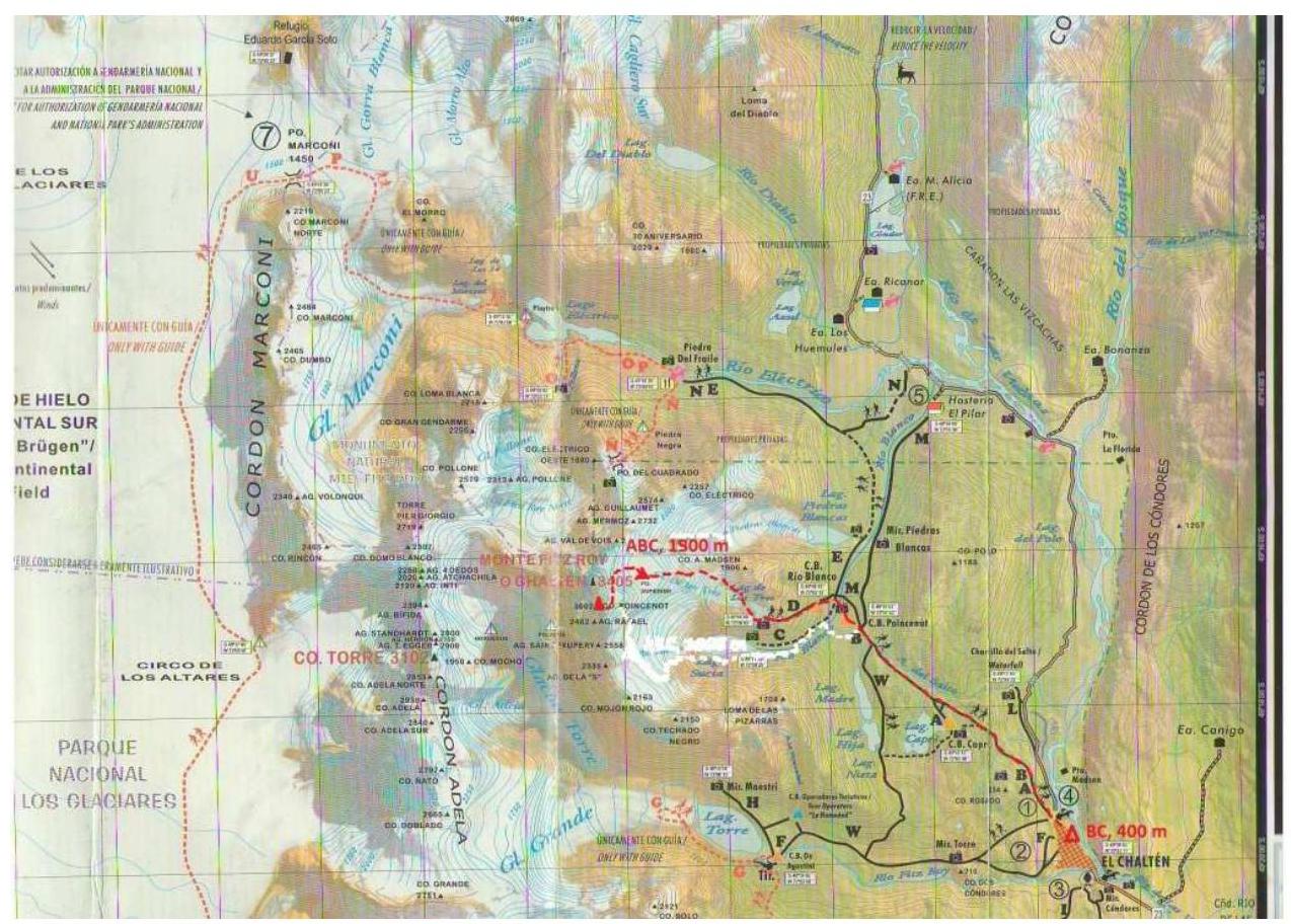
To ascend the peak via this route, a weather window of two to three days was necessary. The internet forecast promised relatively good weather in the second half of the day on February 10 and almost the entire day on February 11. It had snowed shortly before, and the one good weather day on February 10 was used to clear the wall of ice. The ascent was planned for February 11 with a descent on the same day. On February 10, the team moved from the base camp in El Chaltén (400 m) to the advanced base camp Paso Superior (1850 m). They departed from the cave at 3:00 and reached the wall by 6:00.
The technical movement on the route was organized in a way practiced on previous ascents—the first climber moved on a double rope, while the second followed with top-rope protection, collecting gear and memorizing convenient station locations for the subsequent rappel descent via the ascent route.
The choice of leader was based on the prevailing character of the route section: – Grachev led on sections with ice and mixed terrain; – Shabunin led on rock sections with free climbing in the upper part of the route to the summit.
Unfortunately, the good forecast for the entire day on February 11 was only partially correct, and it started snowing in the afternoon. The team decided to ascend until 20:30 and then turn back. Stations in the upper part of the route were not dismantled to speed up the rappel descent. The summit was reached at 20:00. The weather deteriorated significantly, with visibility reduced to 10 m and winds estimated at 35–40 m/s.
For 5 hours in such conditions, they managed to rappel down 7 rope lengths almost blindly. They decided to bivouac on a convenient ledge, as there was a risk of missing the turnoff to the East wall and falling onto the 500-meter Southeast wall.
At night: – the wind gradually subsided; – visibility increased to 100–150 m; – by 5:00, it was possible to continue moving down the ascent route.
Further actions: – by 9:00, they successfully descended to the snow pad under the East wall; – by 12:20, the team descended to the advanced base camp; – by 21:00, the ascent was completed in El Chaltén.
Route Description by Sections
From the base camp in El Chaltén (400 m), follow a well-marked trail to the Poincenot camp (700 m) in 2–2.5 hours. Then turn right and follow the trail towards Laguna De Los Tres in 1–1.5 hours. By passing the lake on the left, ascend the moraine to the glacier tongue in 1 hour. Here, it is necessary to rope up. From the glacier tongue, move upward to a characteristic saddle on the ridge in 1 hour. Then follow the ridge, overcoming two steep rises, to the advanced base camp (ABC Paso Superior). It is advisable to dig a snow cave here. All ascents in this area start from this location.
Then: – Rappel down 20 m to the other side of the ridge onto the glacier. – Roped up, move up the closed glacier to the snow pad under Fitz-Roy peak. – Along the snow pad, with a gradual gain in height, move under the center of the East wall of Poincenot peak. – The route starts from the right part of the characteristic rock "paw," up the ice-snow ramp (start at 1900 m)—3–4 hours from the cave.
Section R0–R4. Duration 400 m, 3–5, M1–M3.
Move up and left along a characteristic snow-ice ledge with rock outcrops. Stations are located on convenient platforms. Occasional rappel loops are encountered.
Section R4–R5. Duration 40 m, 6, M4, fr 6a, A1.
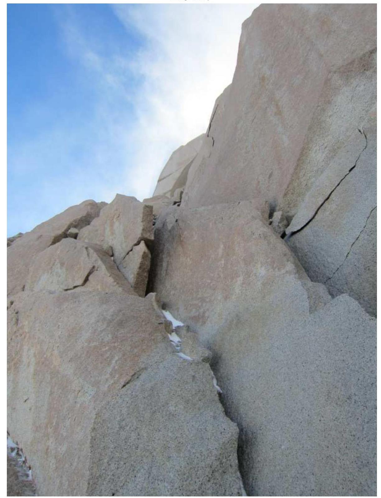
Move straight up a rock-ice wall with good cracks, some filled with ice. Exit into a steep inner corner. The station is inconvenient.
Section R5–R6. Duration 30 m, 5, M4. Move along the right part of the inner corner. Walls are iced. At the top: – Traverse left onto the ridge; – Joining the East and Southeast walls.
Section R6–R7. Duration 420 m, 5. Constantly move left and upward. Many traverses and moderate climbing on walls of average steepness. Exit onto Poincenot peak (3002 m).
Descent from the route is via the ascent route (logical and safe). In windy weather, rappels can be challenging due to the high risk of rope jamming.
UIAA Scheme
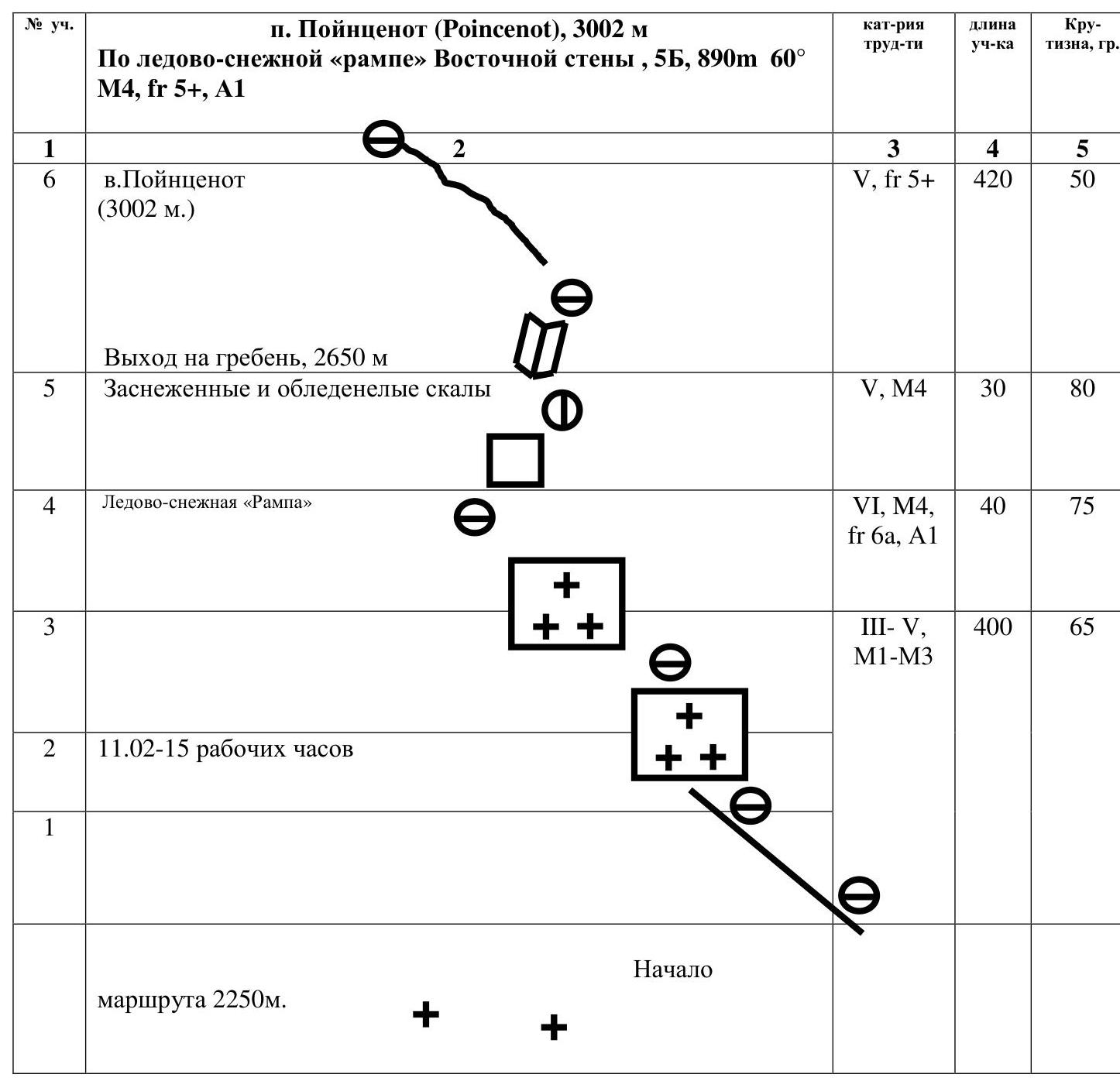
Poincenot Peak, 3002 m
Route: Via the ice-snow "ramp" of the East wall, 5B, 890 m, 60°, M4, fr 5+, A1
| Section # | Section Description | Difficulty Category | Section Length | Steepness, ° |
|---|---|---|---|---|
| R0–R4 | Move up and left along a characteristic snow-ice ledge with rock outcrops. Stations are on convenient platforms. Occasional rappel loops. | 3–5, M1–M3 | 400 m | 65 |
| R4–R5 | Move straight up a rock-ice wall with good cracks, some iced. Exit into a steep inner corner. (Diagram: Ice-snow "ramp"). | 6, M4, fr 6a, A1 | 40 m | 75 |
| R5–R6 | Move along the right part of the inner corner. Walls are iced. At the top: traverse left onto the ridge joining the East and Southeast walls. (Diagram: Snowy and iced rocks; Exit onto the ridge, 2650 m). | 5, M4 | 30 m | 80 |
| R6–R7 | Constantly move left and upward. Many traverses and moderate climbing on walls of average steepness. Exit onto Poincenot peak (3002 m). (Diagram: Poincenot peak, 3002 m). | 5, fr 5+ | 420 m | 50 |
Start of the route: 2250 m. February 11: 15 working hours.
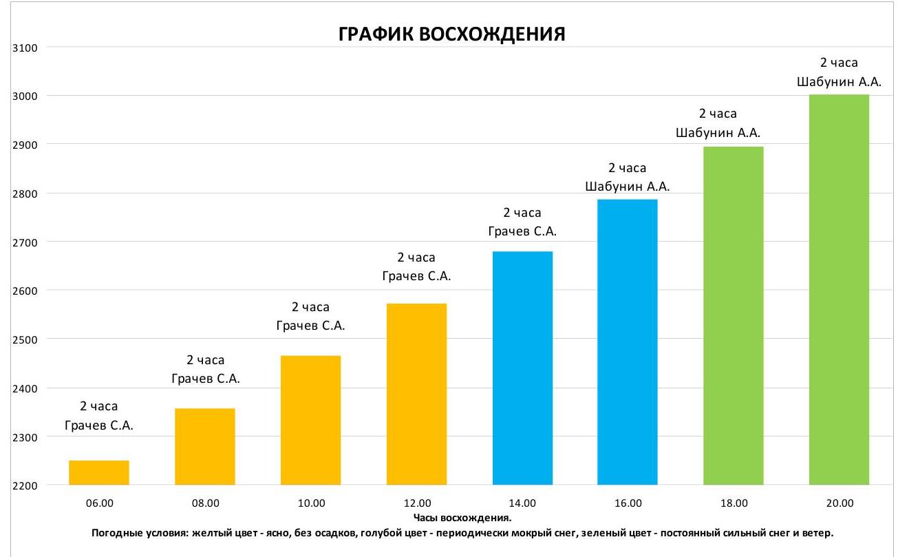
Weather Conditions
– Yellow: clear, no precipitation; – Blue: occasional wet snow; – Green: constant heavy snow and wind.
Start of the route R0–R4

R4–R6

R6–R7
Fitz Roy, 3405 м Torre Standhardt, 2730 м Poincenot, 3002 м Torre Egger, 2850 м Innominata, 2482 м Cerro Torre, 3133 м Saint Exupery, 2558 м Adela Central Mermoz, 2723 м Guillaumet, 2579 м