
2016 Russian Mountaineering Championship
High Altitude Category
Report on the ascent of the Moscow Alpine and Rock Climbing Federation team to Thalay Sagar (6904 m)
Via the counterfort of the North Face, "Moveable Feast" — first ascent, approximately 6B category difficulty.
Senior coach: E.V. Kuznetsova Team leader: S.A. Nilov
Thalay Sagar (6904 m) via the counterfort of the North Face "Moveable Feast"
Ascent Details
- Ascent category: high altitude
- Ascent area: Indian Himalayas, India
- Peak, its height, ascent route: Thalay Sagar (Thalay Sagar) (6904 m) via the counterfort of the North Face
- Difficulty category: 6B (first ascent)
- Route characteristics:
| Route length | 1471 m | |
|---|---|---|
| wall section: | 971 m | |
| sections of V–VI category difficulty | 971 m | |
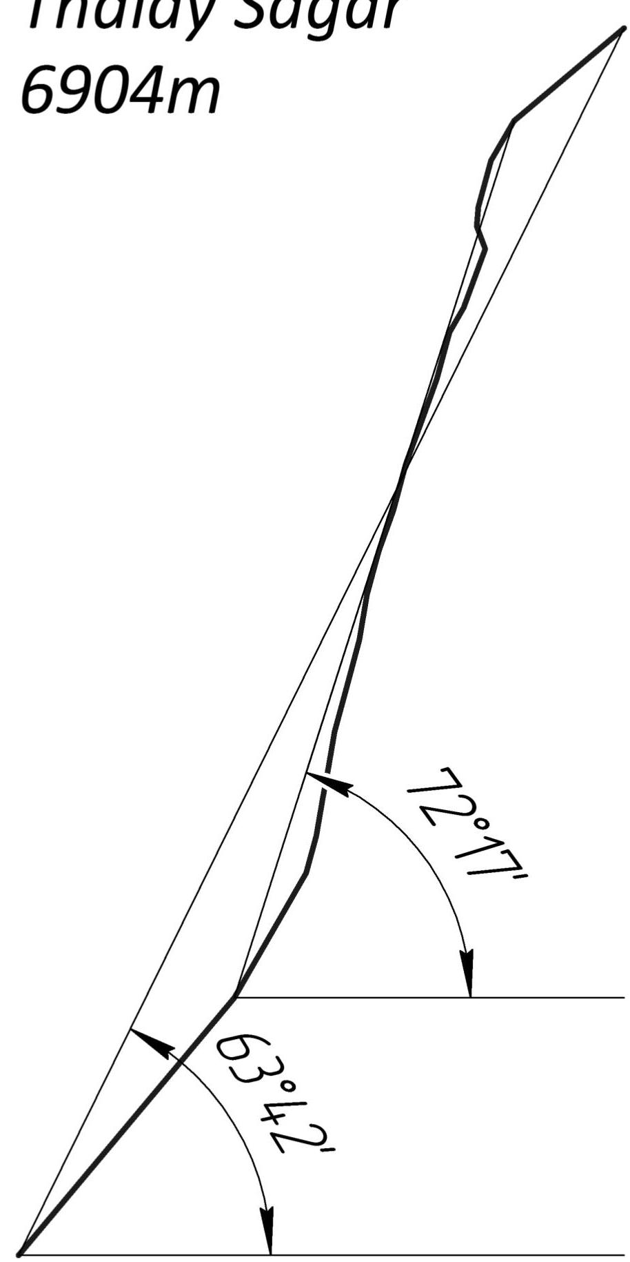
| Height difference | route: | 1204 m |
| wall section: | 870 m | |
| Average steepness | route: | 63° |
| wall section: | 72° |
- Pitons left on the route (including bolts): 0 (0)
- Team leader: Sergey Nilov — Master of Sports
Team members:
- Dmitry Grigoryev — Candidate for Master of Sports
- Dmitry Golovchenko — Candidate for Master of Sports
- Team coach: E.V. Kuznetsova
- Departure from base camp: September 9, 2016
Ascent to the summit: September 17, 2016. Return to base camp: September 18, 2016.
- Demchenko CSKA, Moscow
Technical photo of the route
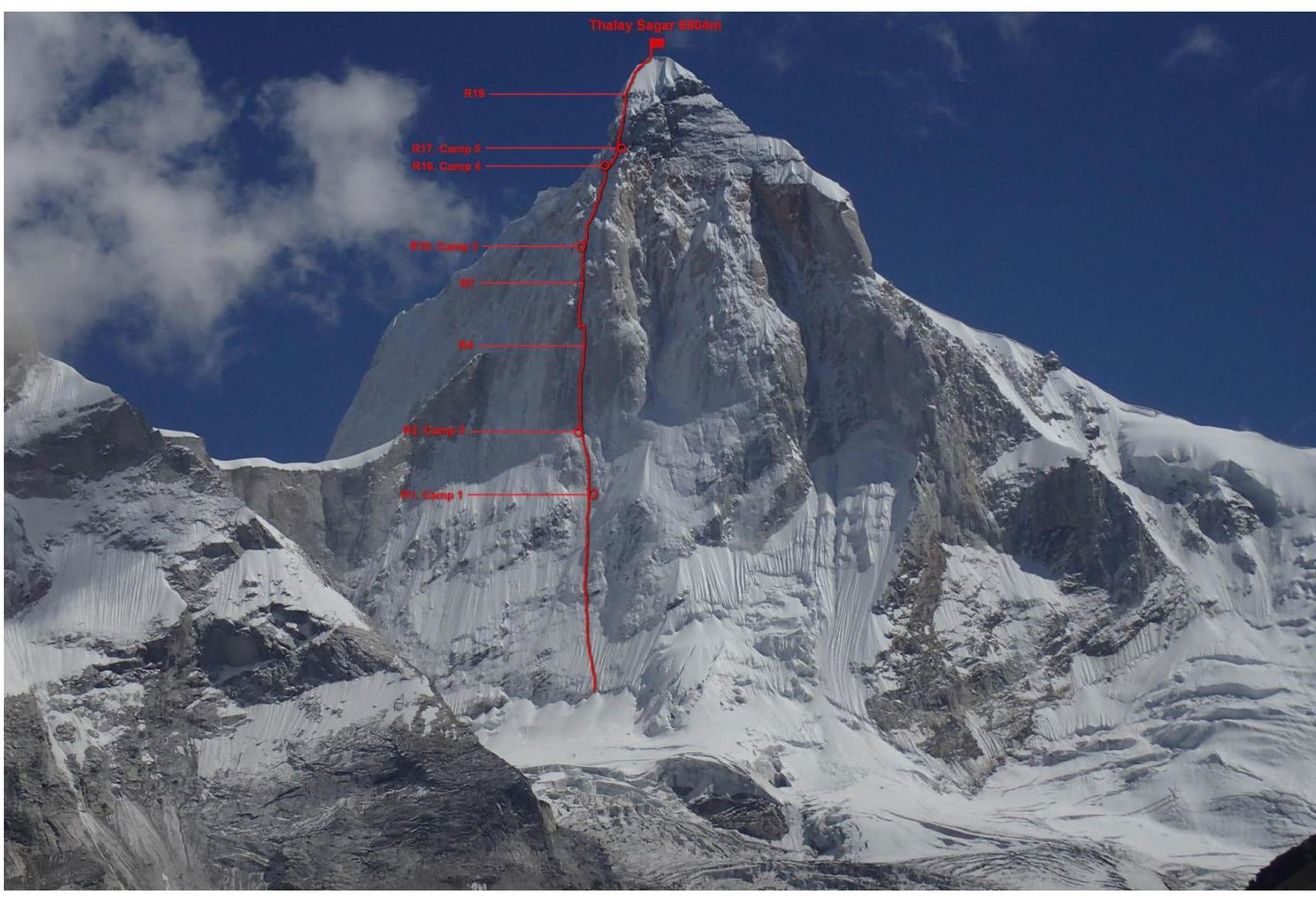
General photo of Thalay Sagar (6904 m) from the North and the route thread
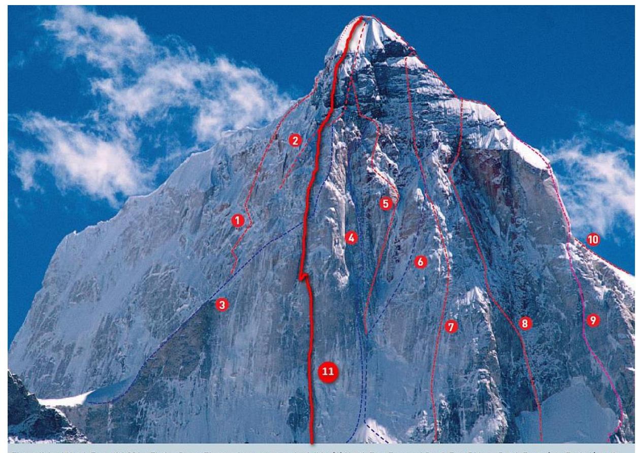
General photo of the mountain and existing routes
The well-iced North Face of 6904 м Thalay Sagar. The top three-quarters is visible.
(1) North East Face and South East Ridge – Dutch Route Ivan Berkel/van de Gevel/Redeker, 2003: c800 м: ED1/2: WI5: V+ and A1. (2) Top section of North East Ridge (Czok/Doeseth/Guidal/Nesheim/Skorek, 1983: c900 м: TD+: VI+ and A1, ice and mixed. This route climbs the left flank of the ridge and is mostly hidden on this photograph). (3) Italian attempt on the North East Ridge and Right Flank (Rosso/Ruffino/Vanetti, 1994: c750 м: ED2: VII and 80°: stopped at the shale band below the corner system later taken by Lindblade and Whimp). (4) One Way Ticket (Benoist/Glairon-Rappaz, 2003: c1,400 м: WI6, M6 and F5b). (5) Central Couloir Direct (Lindblade/Whimp, 1997: c1,400 м: WI5 and VI+). (6) North Face – Original Route (Dekany/Ozsvath, 1991: c1,400 м: ED1/2: V+ and 85°). (7) Russian Direct – High Tension (Bolotov/Davy/Klenov/Pershin, 1999: c1,400 м: F7b and A3). (8) Bulgarian Route – Between Light and Shadow (Hristov/Levakov, 2003: c1,400 м: VII-, A2 and ice/mixed). (9) North West Pillar – Harvest Moon (Burdet/Senf/Siegrist/Weber, 2004: c1,400 м: 6a, A3, WI 5 and M5+: Camp 2 is marked; Camp 1 is just off the bottom of the picture). (10) Top section of West Ridge – Original Route (Kligfield/Thackery/Thexton, 1979: c1,400 м: 60° then 5.8 and A1). MELVIN REDEKER
The team's line is number 11
Panoramic photo of the area from the North

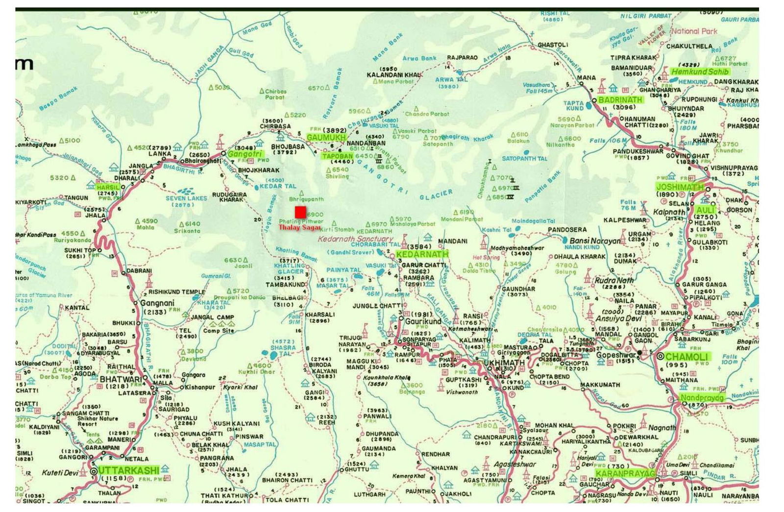
Map of the area
Description of the area
The Gangotri group is a collection of mountains in the western part of the Garhwal Himalayas, located in the state of Uttarakhand in northern India. They surround the Gangotri glacier and consist of peaks famous either for their significance in Hinduism or their challenging routes, or both. Ascents of the three peaks: Thalay Sagar, Shivling, and Meru, have been awarded the most prestigious award in mountaineering — the Piolet d'Or.
The most famous peaks are:
- Chaukhamba I–IV. A four-peak massif, with Chaukhamba I (7138 m) being the highest point in the group.
- Kedarnath (6940 m) – the highest point to the southwest of the glacier.
- Thalay Sagar (6904 m) – a steep rocky peak, possibly the most technically difficult mountain in the entire group.
- Shivling (6543 m) – another steep rocky peak with two summits, offering a striking view from the Gaumukh glacier, visited by thousands of pilgrims annually. As a symbol of Shiva, it is the most revered peak in the group.
- Meru (6660 m) stands between Thalay Sagar and Shivling. Several extremely challenging routes lead to the summit, which have only recently been climbed despite numerous attempts by top mountaineers from around the world.
- Bhagirathi I–III (6856 m, 6512 m, and 6454 m, respectively) — these peaks have moderate complexity on the reverse side but very steep and often overhanging walls on the glacier side. In particular, Bhagirathi III is one of the most technically challenging peaks in the Himalayas.
History of ascents
-
1979 — first ascent via the Northwest Ridge. An Anglo-American team consisting of Roy Kligfield, John Thackray, and Peter Thexton. 10 porters, bears on the way, a week-long approach. The ascent took 8 days. Summit on June 24, 1979.
-
1983 — A Polish-Norwegian team climbed a new route via the Northeast counterfort. Out of 7 team members, five reached the summit: Poles Janusz Skorek and Andrzej Czok, and Norwegians Hans Christian Doseth, Havard Nesheim, and Frode Guldal. Ascent duration from August 16 to August 24.
-
1991 — In August, a team from Hungary arrived at the mountain: Ozsváth Attila, Dékány Peter, Kiszely György, Szikszai Attila, and Berecz Gábor. In the first half of September, the first two climbed a new route via the North Face, while the trio attempted to repeat the Polish-Norwegian route but retreated due to high avalanche danger.
-
1992 — In May, Scots led by Keith Milne returned to the South Face. The team required almost a month (May 9, 1993 – June 6, 1993) to complete the ascent, with Keith Milne and Tom Prentice finishing what they started 2 years earlier.
-
1998 — A Korean team led by Hyung Jin Kim worked on the North Face. 75 m from the summit, the leading trio was caught in a cornice collapse; no one survived. Nevertheless, the team decided to complete the route. The same year, a duo, Andrew Lindblade (Australia) and Athol Whimp (New Zealand), returned to the North Face. From September 13 to 25, they managed to climb a new line on the North Face, for which they received the prestigious Piolet d'Or award in 1999.
-
1999 — This year, a Russian team consisting of Klenov, Davey, Bolotov, and Pershin visited Thalay Sagar for the first time. On May 27, 1999, after 11 days of work on the mountain, the team stood on the summit in full, having laid the most direct route on the North Face, known as "High Tension" or "Russian Directissima" in the Western world.
-
2003 — The first new route of the year was the "Dutch Route" on the East Face by Mike van Berkel, Cas van de Gevel, and Melvin Redeker. Duration: September 17–23. Another new route on the North Face was climbed by French climbers Stéphane Benoist and Patrice Glairon-Rappaz, named "One Way Ticket." The line runs left of the central couloir and merges with the Lindblade-Whimp route at the top. The French team completed it in 10 days, reaching the summit on September 30. In October, a Bulgarian duo, Nicola Levakov and Hristo Hristov, climbed a new route, "Between the Light and the Shadow," on the North Face, to the right of High Tension. The Bulgarians climbed in capsule style and, after reaching 6450 m, continued to the summit without a bivouac but were unable to finish in a day and had to spend the night in a snow cave. The next day, they reached the summit; however, Nicola suffered severe frostbite and was later evacuated from the base camp by helicopter.
-
2004 — In September, a German-Swiss team consisting of Thomas Senf, Stephan Siegrist, Ralph Weber, and Denis Burdet climbed the route "Harvest Moon" via the impressive Northwest Ridge. They fixed the entire technical section and ascended to the summit in alpine style from Camp 2.
-
2006 — A large Korean team, primarily composed of members from the Seoul Alpine Rescue Team, totaling 23 people, led by Kim Hyeong-Seop, arrived at the North Face of Thalay Sagar on August 1. After acclimatizing on Jogin III, the team focused on the main objective. It took them 3 weeks to ascend via a new route, which they named "Period For Friends" in memory of their companions who died in 1998.
-
2015 — Basques Felix Criado, Adrian Legarra, Txus Lizarraga, Ekaitz Maiz, and Alex Txikon, along with Italian Daniele Nardi, climbed a variant on the Northwest Ridge but did not reach the summit. Initially, they followed the Harvest Moon route for 700 m, then deviated directly onto the counterfort, climbing 11 pitches on it. The difficulty of the ITO was up to A3, and mixed climbing up to M6.
Tactical actions of the team
Before departing for the area, we gathered all available information about the peak and the history of ascents. We also determined that September is the best time for climbing, as the weather is still warm, the days are long, and the monsoon has passed, making the weather more stable.
Before departing, the team actively engaged in general physical preparation (GFP) and visited various climbing gyms in Moscow.
The area is high-altitude; the base camp is located at 4700 m. The nearest peaks are above 6000 m, and Thalay Sagar is 6904 m, so we had to acclimatize actively. As the first stage of acclimatization, the team independently (without porters) carried part of the gear from the village of Gangotri to the base camp near Kedarnath Lake, a total ascent of about 600 m. The second stage involved various activities at the base camp (construction, walks around the area, and slacklining), as well as reconnaissance of the approach to the route. The third stage was an ascent to the route. The team spent the night at 5700 m, assessed the condition and behavior of the route, prepared the first bivouac under the start of the route, and carried some equipment there before returning to the base camp in the green zone.
After two days of rest and active recovery, the team departed for the ascent. Unlike the previous ascent, which took over a day to approach the route, this time the team reached the starting point in 6 hours.
One of the principal decisions made before leaving Moscow was to attempt to climb the North Face without using a platform. To our knowledge, no team had attempted this before due to the peak's extreme steepness. Therefore, we had to spend a significant amount of time organizing bivouacs on the route. To expand the area of the ledges, the team wove snow catchers from ropes, filled them with large blocks, and then compacted them with snow. This allowed us to set up lying-down bivouacs throughout the ascent, as rest during the climb is crucial.
For high-altitude food, we used instant noodles and dry mashed potatoes. Proteins: sausage and lard brought from Moscow. Snacks and quick carbohydrates included:
- chocolate bars
- chocolate slabs
- caramel
- nuts
- dried fruits. We cooked on a JetBoil gas stove with a 1-liter volume.
The descent from the route followed the 1979 pioneers' route, initially heading West, then South, and finally Northwest. On the route, the team used 50-meter ropes, 1 dynamic and 4 static. To complete the route, anchor pitons, protection gear (friends, cams), crampons, and ice axes are necessary.
Brief description of the route by sections
R1 From the Ranth Klift directly up the snow-ice slope. First bivouac. Semi-comfortable ledge made of snow. 350 m, 50°, III R2 Continue moving up the snow-ice slope to the base of the first bastion. Bivouac on a semi-comfortable snow ledge. 150 m, 60°, IV R3 Start moving up the bastion. Up the ice-filled internal corner. Station under a small overhang, semi-comfortable. 40 m, 80°, VI, A2 R4 Continue moving up the internal corner and crack system. Station in the internal corner under an overhang, semi-comfortable. 40 m, 80°, VI, A2 R5 Move up the crack system. Complex ITO. 30 m, 80°, VI, A3 R6 Ten-meter pendulum left to the ice-filled internal corner. Up the internal corner 30 m. Protection on ice screws, sometimes on protection gear. 40 m, 80°, VI, A2 R7 Up the disappearing internal corner and then along the wall sections to two large rocks on the counterfort ridge. 50 m, 75°, VI, A2 R8 Along the wall sections filled with flowing ice, move up towards the black rock bastion. 49 m, 75°, VI R9 Up the huge internal corner filled with flowing ice. 48 m, 80°, VI R10 Continue moving up the wall sections filled with flowing ice. Complex climbing. Bivouac on a ledge cut into the ice. 47 m, 75°, VI R11 Move along the system of ledges filled with flowing ice. 45 m, 70°, VI R12 Up the firn snow, sometimes very steep, towards the converging ridges. 49 m, 75°, VI R13 Up the system of small wall sections. 48 m, 70°, V R14 Up the firn snow and flowing ice. 47 m, 70°, VI R15 Up the ledges and wall sections. 50 m, 75°, VI R16 Traverse along the snowy slope up left under the rocks. Bivouac. Comfortable snow and ice ledge. 30 m, 60°, V R17 Along the inclined wall filled with ice and covered with snow, up right under the black rocks, the summit bastion. Directly under the rocks, a ledge cut into the ice for bivouac. 65 m, 70°, VI R18 Up the bastion directly. Half a rope length of complex ITO. 25 m, 110°, VI, A3 R19 Further, the wall becomes less steep, and climbing becomes possible. 20 m, 85°, VI, A1 R20 Follow the wall sections filled with ice and covered with snow towards the huge chimney and then up it. At the end of the chimney, exit right. 50 m, 75°, VI R21 Up the snow-ice slope, slightly bearing right. 48 m, 60°, V R22 Up the snow-ice slope and then along the snow to the summit. 150 m, 40°, IV
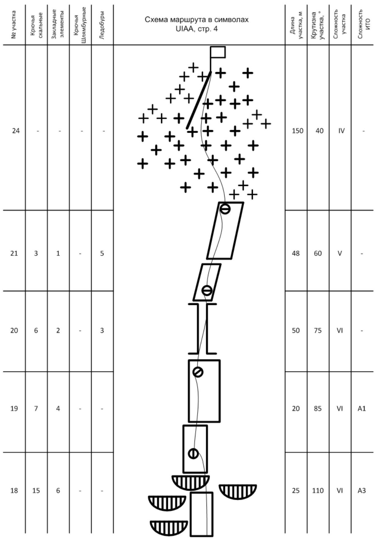
Route diagram in UIAA symbols
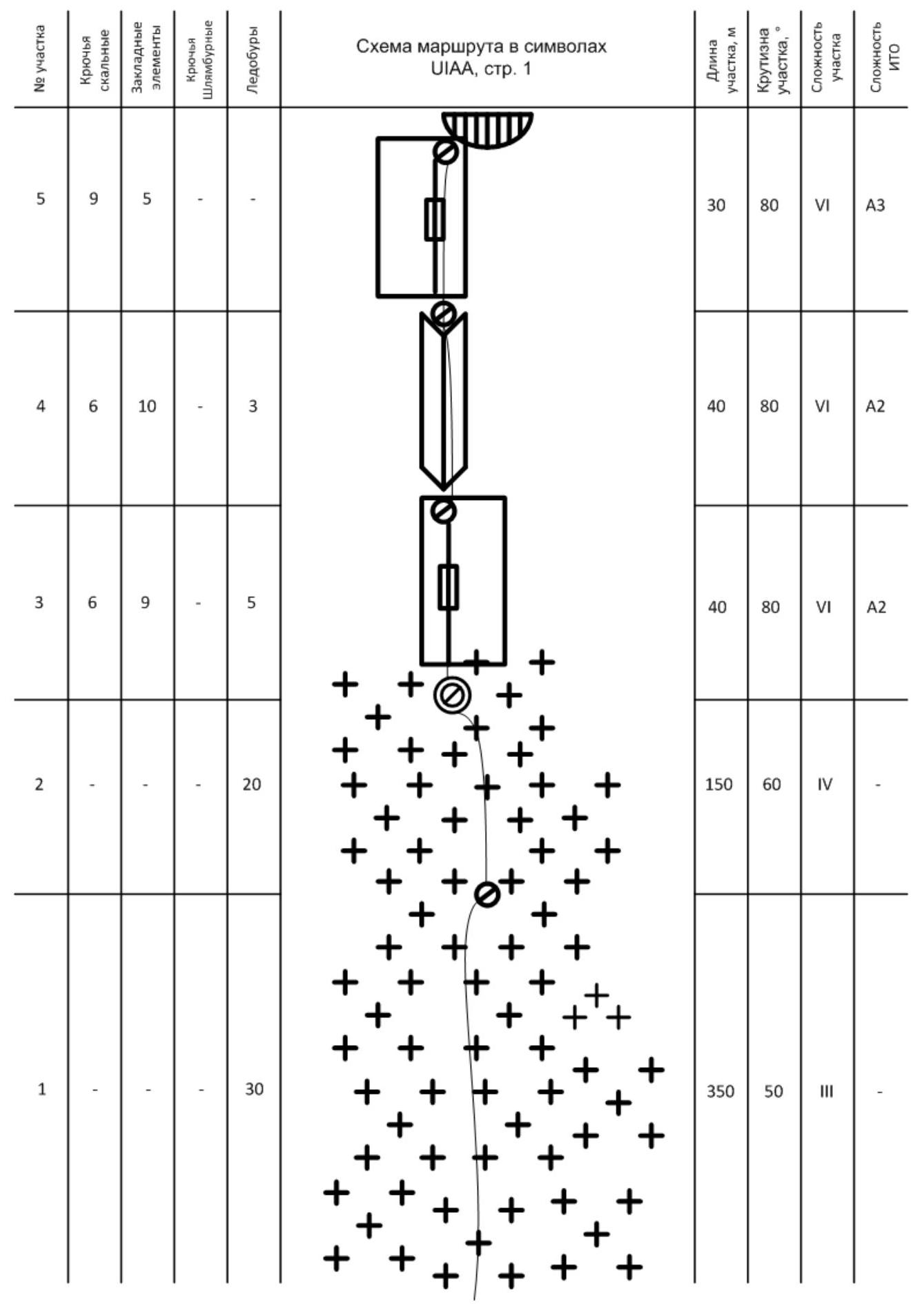
| Pitch № | Rock pitons | Protection gear | Bolt pitons | Ice screws | Pitch length, m | Pitch steepness, ° | Pitch difficulty | ITO difficulty |
|---|---|---|---|---|---|---|---|---|
| 1 | – | – | – | 30 | 350 | 50° | III | – |
| 2 | – | – | – | 20 | 150 | 60° | IV | – |
| 3 | 6 | 9 | 5 | – | 40 | 80° | VI | A2 |
| 4 | 6 | 10 | 3 | – | 40 | 80° | VI | A2 |
| 5 | 9 | 5 | – | – | 30 | 80° | VI | A3 |
| 6 | 3 | 3 | – | 6 | 40 | 80° | VI | A2 |
| 7 | 7 | 8 | – | 2 | 50 | 75° | VI | A2 |
| 8 | 6 | 2 | – | 3 | 49 | 75° | VI | – |
| 9 | 5 | 1 | – | 6 | 48 | 80° | VI | – |
| 10 | 7 | 3 | – | 2 | 47 | 75° | VI | – |
| 11 | 4 | 3 | – | 3 | 45 | 70° | VI | – |
| 12 | 5 | 1 | – | 2 | 49 | 75° | VI | – |
| 13 | 5 | 2 | – | 3 | 48 | 70° | V | – |
| 14 | 3 | 1 | – | 5 | 47 | 70° | VI | – |
| 15 | 5 | 2 | – | 3 | 50 | 75° | VI | – |
| 16 | 2 | – | – | 1 | 30 | 60° | V | – |
| 17 | 4 | 1 | – | 5 | 65 | 70° | VI | – |
| 18 | 15 | 6 | – | – | 25 | 110° | VI | A3 |
| 19 | 7 | 4 | – | – | 20 | 85° | VI | A1 |
| 20 | 6 | 2 | – | 3 | 50 | 75° | VI | – |
| 21 | 3 | 1 | – | 5 | 48 | 60° | V | – |
| 22 | – | – | – | – | 150 | 40° | IV | – |
Drawn profile of the route
Thalay Sagar
6904 м
Height gain chart
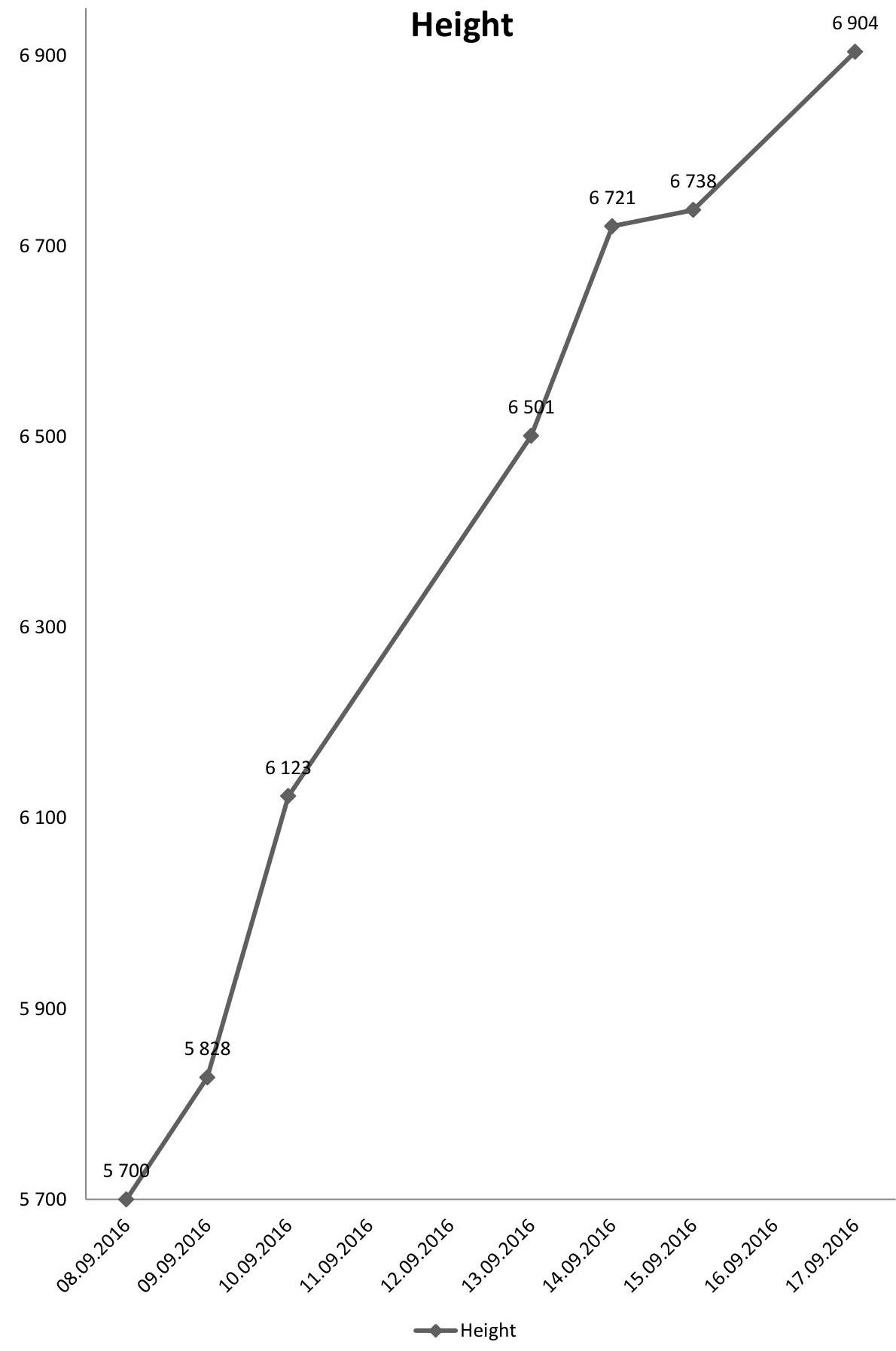
Photo illustrations
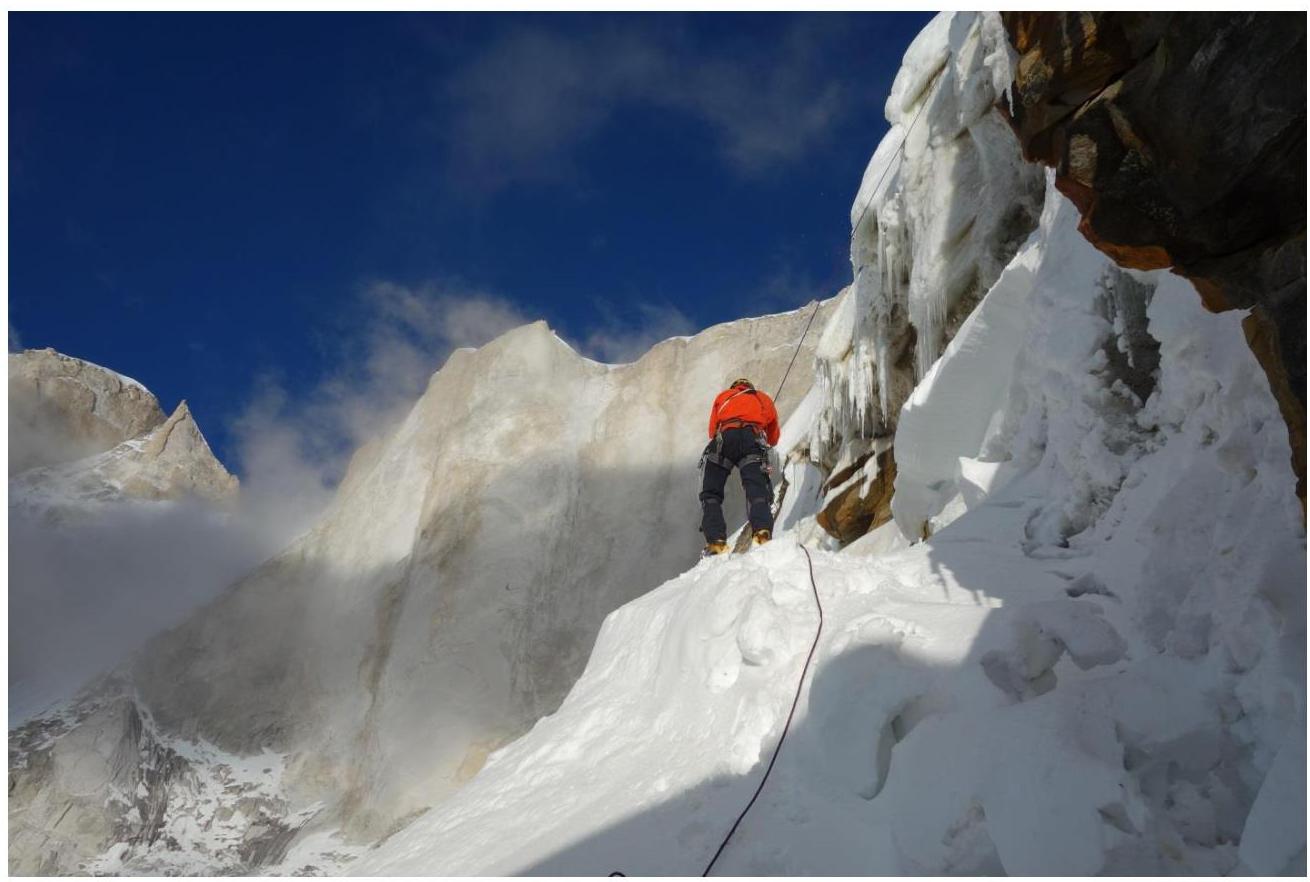
Photo 1. Pitch R1
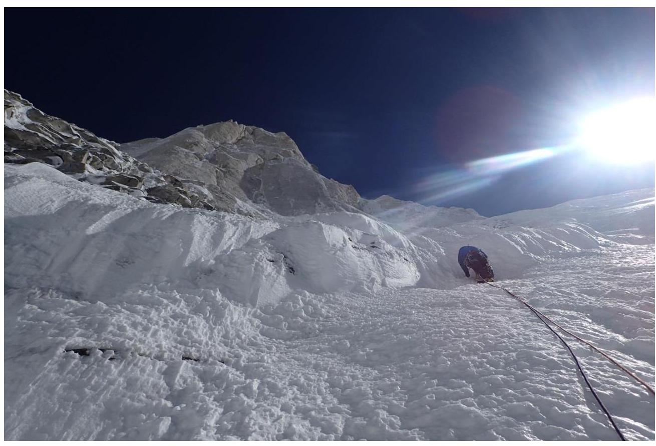
Photo 2. Pitch R2
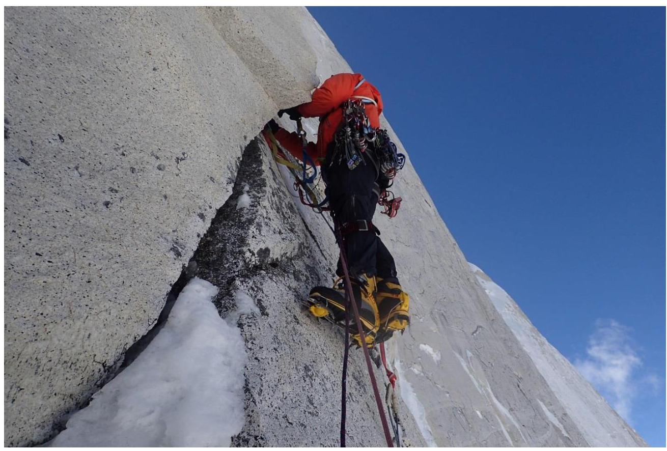
Photo 3. Pitch R3
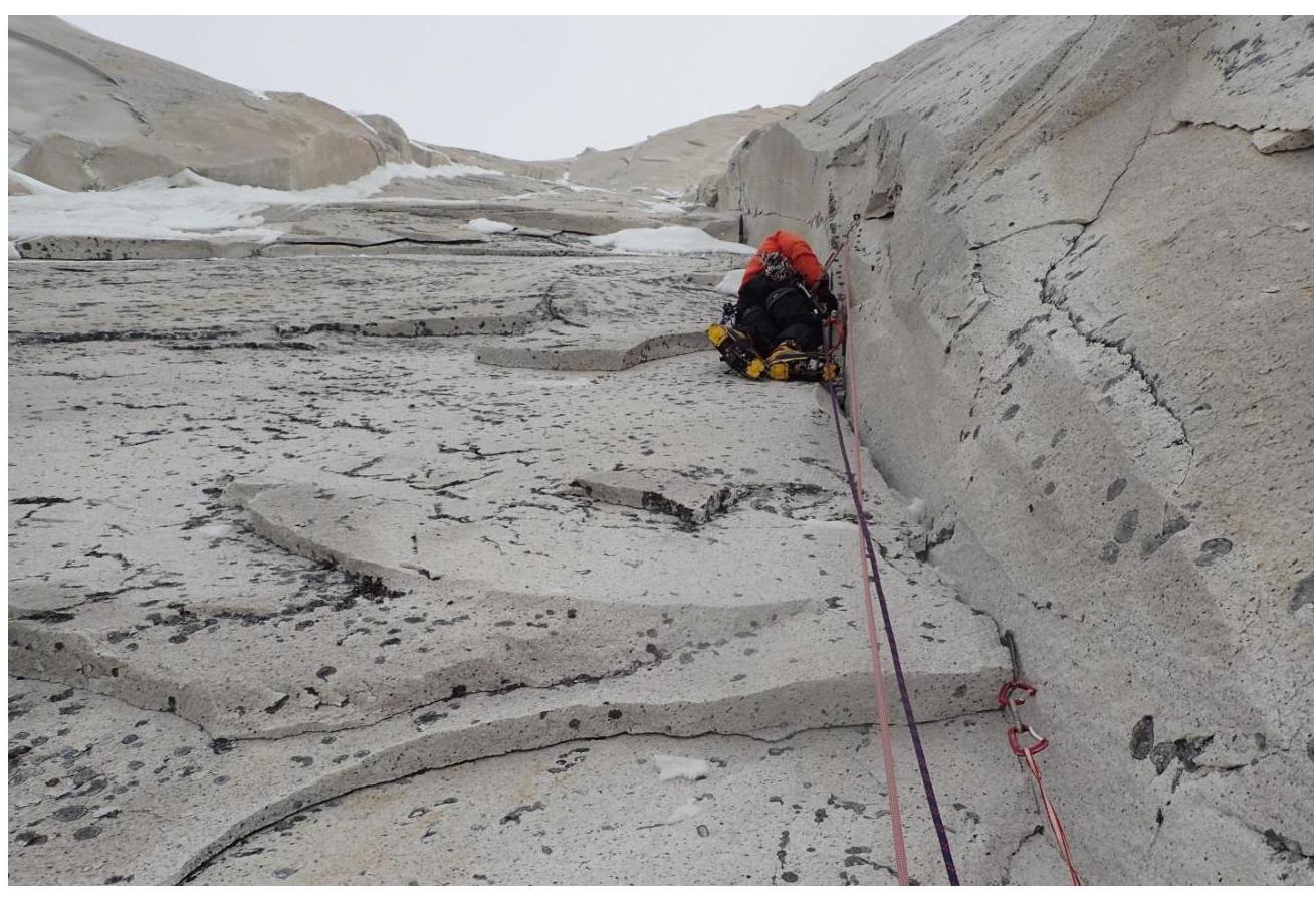
Photo 4. Pitch R4
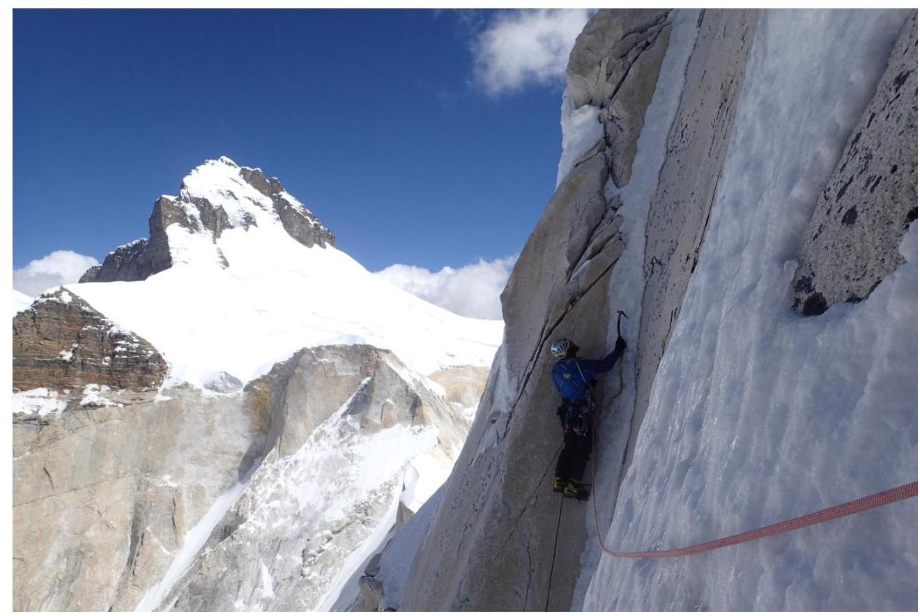
Photo 5. Pitch R6
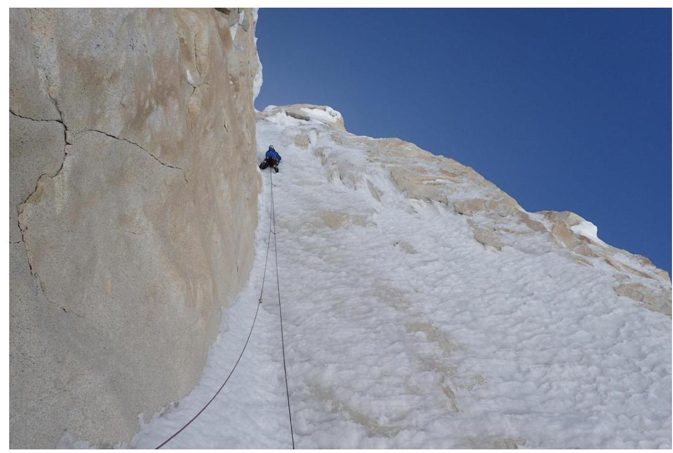
Photo 6. Pitch R8
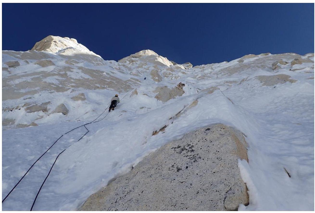
Photo 7. Pitch R10
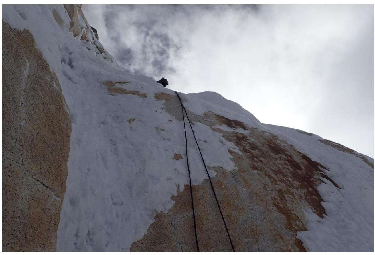
Photo 8. Pitch R12
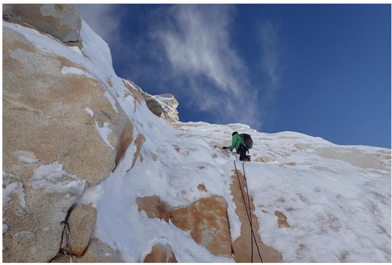
Photo 9. Pitch R14
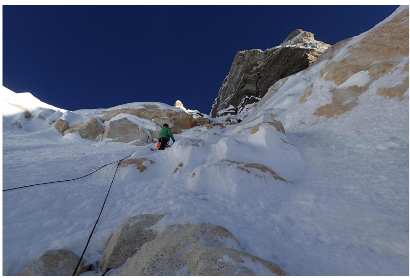
Photo 10. Pitch R15

Photo 11. Pitch R17
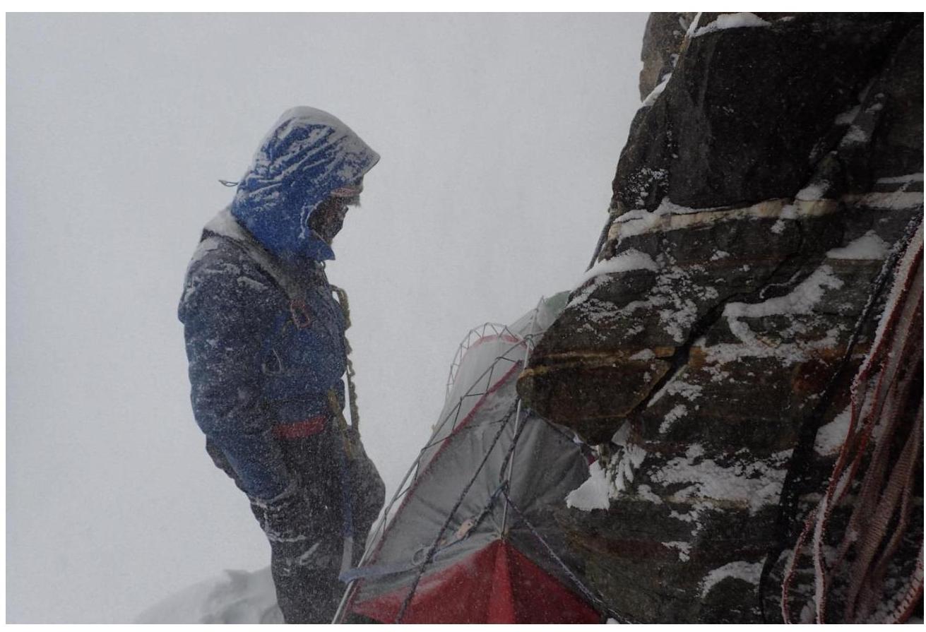
Photo 12. Bivouac 4
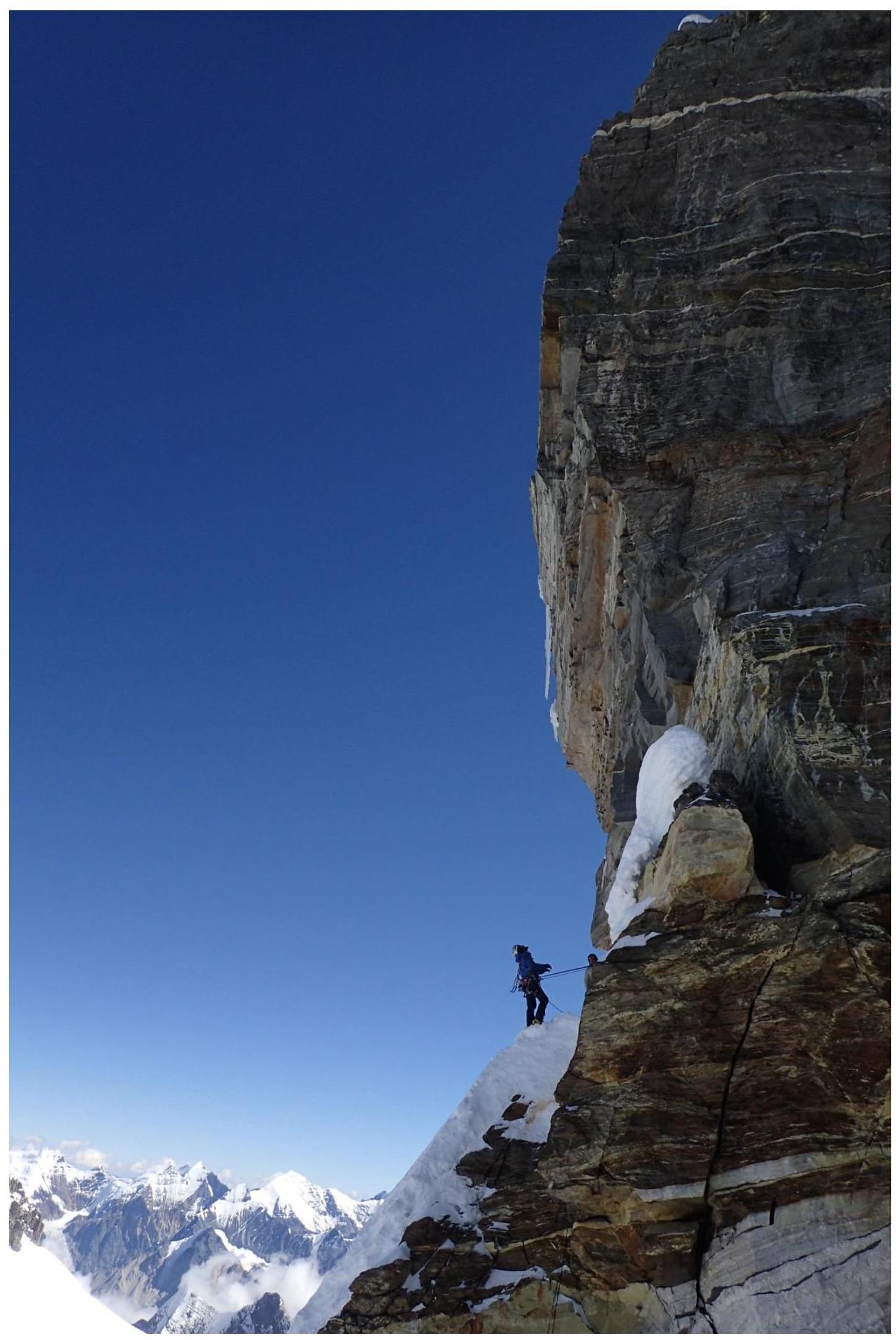
Photo 13. Pitch R18
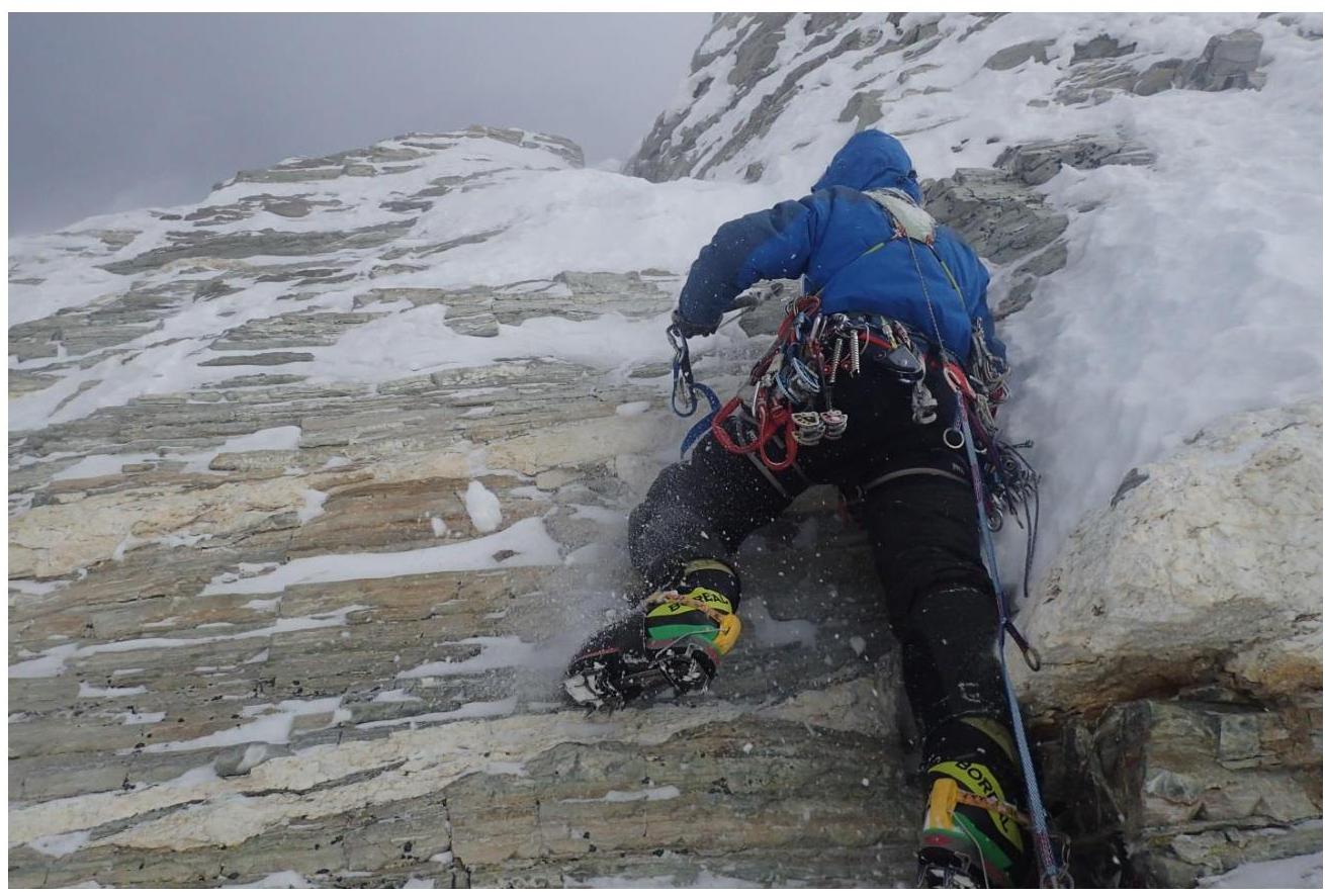
Photo 14. Pitch R20
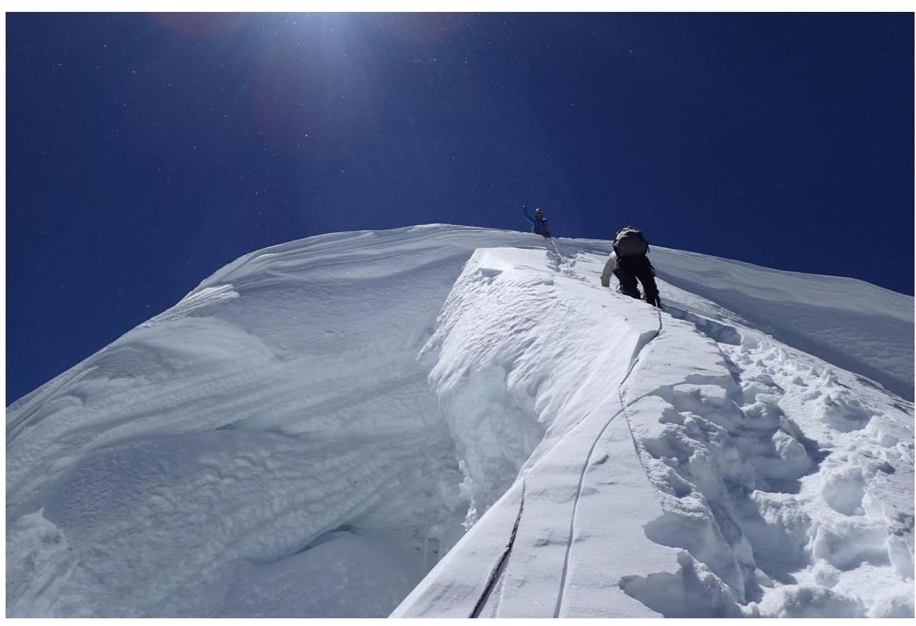
Photo 15. Pitch 23
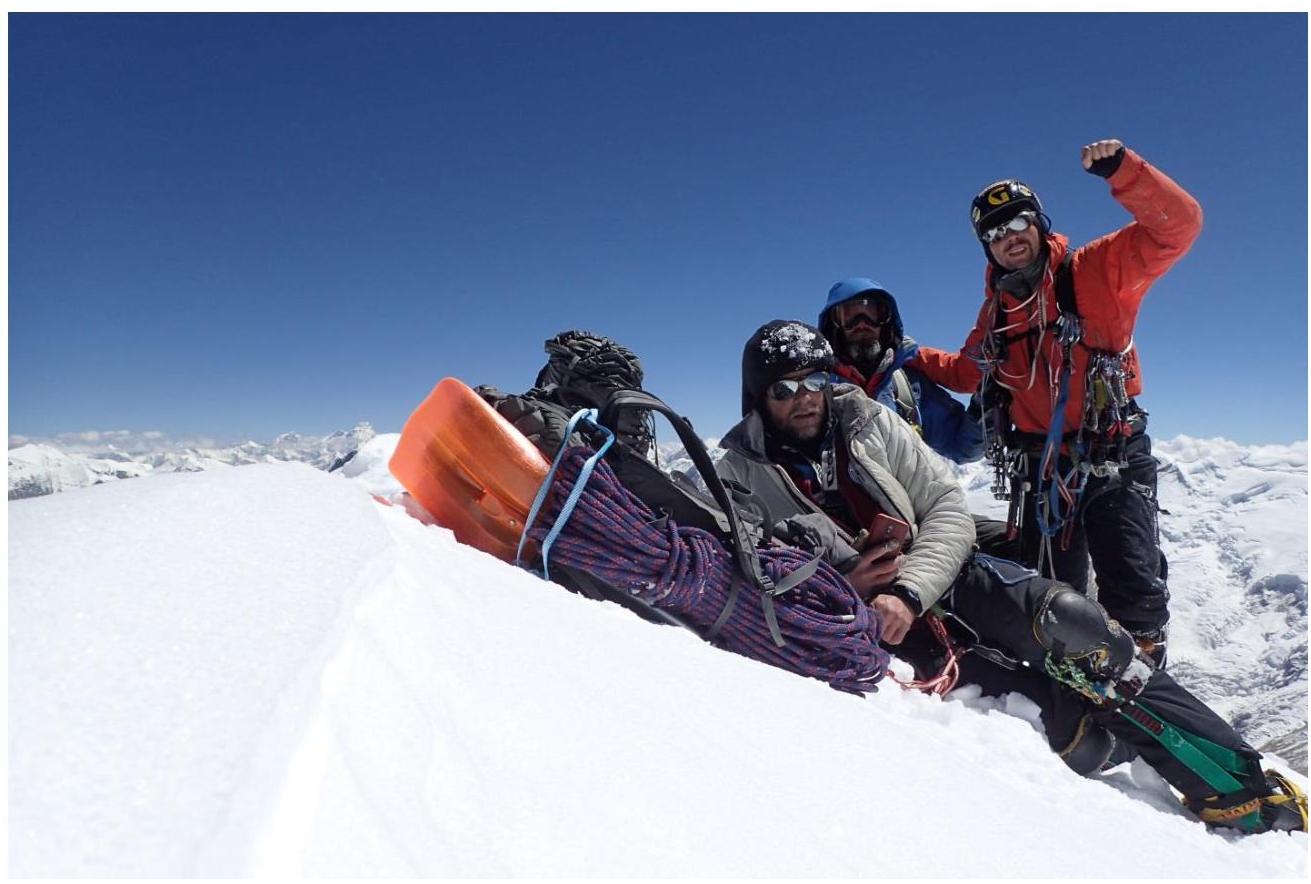
Photo 16. Team on the summit of Thalay Sagar 6904 m

Photo 17. Descent via the Southwest Ridge
Comments
Sign in to leave a comment