Chelyabinsk Region Alpinism Federation
High-Altitude Technical Climbing Category
Report
on the ascent to the summit of McKinley, 6196 m, via West Rib
approximately 5B category of difficulty
Climbing Passport
- Competition class: Russian Championship, high-altitude technical class
- Region — Alaska, Alaska Range;
- Summit — McKinley 6196 m;
- Ascent route: via West Rib;
- Expected category of difficulty — 5B;
- Route characteristics: snow and ice; height difference: from the ice airstrip — 4000 m, West Rib — 2796 m; length: from the ice airstrip — 23500 m, West Rib — 5610 m; length of sections with 5th category of difficulty — 1590 m; average steepness — 34 degrees;
- Equipment used: rock pitons and protection — 12, ice screws — 28, snow stakes — 16;
- Total climbing hours: 39.5 hours; climbing days — 7 (including 1 rest day)
- Team: Chelyabinsk Region Alpinism Federation
Team leader — Soldatov Sergey Yuryevich — Master of Sports, Magnitogorsk. Participants: Igolkin Viktor Ivanovich — Master of Sports, Magnitogorsk; Kondrashov Vladimir Viktorovich — Candidate for Master of Sports, Chelyabinsk
-
Team coach: Igolkin Viktor Ivanovich — Master of Sports, 1st category instructor;
-
Dates of ascent:
- departure to the approach (2160 m) — June 3, 2008
- departure to the route from ABC (3400 m) — June 8, 2006 at 11:00
- summit — June 14, 2008 at 21:00
- descent to Camp II (4950 m) — June 15, 2008 at 01:00
- descent to the glacier airstrip (2160 m) — July 17, 2008 at 17:00
-
Organizing body: Chelyabinsk Region Alpinism Federation.
"West Rib" route scheme in UIAA symbols
| June 14, 2008 21:00 | R18 | 6196 | |||||||
|---|---|---|---|---|---|---|---|---|---|
| no | 3 | no | R17–R18 | 250 | 10 | 3A | |||
| no | no | no | R16–R17 | 300 | 25 | 3A | |||
| no | no | no | R15–R16 | 250 | 10 | 2A | |||
| no | no | no | R14–R15 | 900 | 50 | 5A | 5450 | ||
| no | no | no | R13–R14 | 600 | 35 | 4A | |||
| no | no | no | R12–R13 | 90 | 15 | 2A | |||
| 12 | 4 | 1 | R11–R12 | 140 | 50 | 56 | |||
| June 14, 2008 00:00 June 10, 2008 | no | no | no | R10–R11 | 100 | 25 | 4A | 4950 |
R2 ||| no | no | no || R9–R10 | 250 | 20 | 3Б |||| 1 | no | 1 || R8–R9 |
50 | 55 | 5Б |||| no | no | no || R7–R8 | 750 | 25 | 3Б |||| no | no | no
|| R6–R7 | 60 | 50 | 56 | 4550 ||| no | no | no || R5–R6 | 800 | 35 | 4Б ||||
no | no | no || R4–R5 | 350 | 15 | 2Б ||| June 9, 2008 0 June 8, 2008 0 | no |
ret | 4 || R3–R4 | 200 | 40 | 5Б | 3900 R1 ||| 1 | 9 | no || R2–R3 | 180 | 45 |
4Б |||| 12 | no | 6 || R1–R2 | 500 | 55 | 3Б |||| June 8, 2008 ABC | no | no |
no || R0–R1 | 100 | 35 | 4Б | 3400 ABC || Overnight stays | Pitons ||||||||||| Route
scheme in UIAA symbols | Section # | Length | Steepness, degrees | Category of difficulty |
Height ||| 28 | 16 | 12
|||||||
Ariznam Bekhozuania
| Ariznan | Bekhozuani |
|---|---|
| Verauna Mak–Kunan | 6196 m 2100 m |
| Zheneroga | 42 |
| Zhengai | 810 |
| Apa | 2700 |
| Apegan | 2100 |
| Apegan | 2100 |
| Apegan | 2100 |
| Apa | 2100 |
| Apegan | 2100 |
| Apegan | 2100 |
| Apegan | 2100 |
| Apegan | 2100 |
| Apegan | 2100 |
| Apa | 2100 |
| Apegan | 2100 |
| Apegan | 2100 |
| Apegan | 2100 |
| Apegan | 2100 |
| Apegan | 2100 |
| Apegan | 2100 |
| Apegan | 2100 |
| Apegan | 2100 |
| Apegan | 2100 |
| Apegan | 2100 |
| Apegan | 2100 |
| Apegan | 2100 |
| Apegan | 2100 |
| Apegan | 2100 |
| Apegan | 2100 |
| Apegan | 2100 |
| Apegan | 2100 |
| Apegan | 2100 |
| Apegan | 2100 |
| Apegan | 2100 |
| Apegan | 2100 |
| Apegan | 2100 |
| Apegan | 2100 |
| Apegan | 2100 |
| Apegan | 2100 |
| Apegan | 2100 |
| Apegan | 2100 |
| Apegan | 2100 |
| Apegan | 2100 |
| Apegan | 2100 |
Tactical Actions of the Team
Based on the gathered material, the team studied the tactics of various groups' ascents, including those of Yanochkin V. and Nevorotin V. K. via the classic route in 1998 to this summit. The following factors were taken into account:
- The most favorable period for ascents
- Working in polar latitudes and low temperatures at altitudes above 4000 m
- Time difference of 11 hours with Magnitogorsk
- Impossibility of quick physiological adaptation of the body
- Duration of daylight
- Unpredictability of weather
The ascent tactic chosen was alpine, with lifts and descents for cargo, the initial weight of which was about 40 kg per person when departing from the airstrip.
The group had:
- sleds, which significantly helped in transporting cargo.
In case of prolonged bad weather, additional food for 4 days was taken beyond the planned amount.
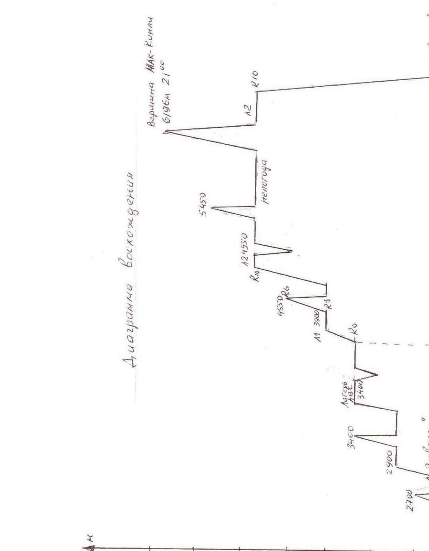
On the approach, there were 2 intermediate camps and ABC at an altitude of 3400 m, and on the route itself — camps:
- #1 (3900)
- #2 (5000)
- #3 (5240)
The preliminary exit to the 5500 m mark and weather conditions showed the inexpediency of organizing Camp #3. The condition and preparation of the participants allowed them to successfully storm the summit from the 4950 m mark and film the ascent.
The most challenging sections with hard ice were:
- from ABC to Camp #1 (11 ropes)
- on the ridge at the 4600 m mark (2 ropes)
- above Camp #2
- when exiting to the pre-summit plateau.
Brief Overview of the Ascent Region
Deep in Alaska rises the highest massif of North America — McKinley (6193 m). The snowy giant, located at 63° N in the Alaska Range, is not only the highest summit in North America but also one of the world's highest mountains. The peaks of the Himalayas and the Andes, undoubtedly, surpass it, but they rise above plateaus with absolute heights of 3000 m and above. Here, the wide Kuskokwim valley, where the northern slope of the massif descends, is located at a height of 450 m above sea level.
Among McKinley's nearest companions are very challenging peaks for mountaineers:
- Foraker (5303 m) — the second-highest in this group, was conquered by only a few mountaineering teams;
- Hunter (4443 m);
- Moose's Tooth (3150 m) — extremely difficult to ascend and were conquered quite recently.
The chain of the Wrangell Mountains, lying closer to the Gulf of Alaska, includes two high peaks: Blackburn (4918 m) and Bona (5004 m). The second-highest peak in the region is Logan (6050 m), and the third is St. Elias (5488 m).
The high latitude at which the summit is located, its relative proximity to the ocean (250 km from the Cook Inlet), and the cyclonic center above the Aleutian Islands, from which moist winds easily penetrate into the Yukon and Kuskokwim valleys, bringing heavy snowfalls — all this creates harsh climatic conditions here, perhaps one of the most challenging in the world.
In winter, temperatures can drop to -60°C even in the valley, and in summer, average temperatures are around 12°C–14°C and can occasionally rise to 30°C. However, nights are cold even in summer, and only in July are there almost no nighttime frosts.
Alaska's climate and its mountainous regions are not only cold but also windy and wet. Cold southwesterly winds prevail (on the peaks, their speed can reach 160 km/h) with short, even stronger gusts, very dangerous for mountaineers. Periods of bad weather last a very long time. For example, in 1947, out of ninety days in the three summer months, there were only five clear days, and on average, out of three days, two were cloudy.
Although precipitation in the valleys of Central Alaska is low, storms on the mountain slopes bring a lot of snow, falling almost all year round. In summer, there can be up to 15–20 days with precipitation per month. The snow line is low — at an altitude of 1650 m. It is not surprising that on the slopes of such high mountains as McKinley and in the adjacent gorges, huge glaciers are born, the largest of which are:
- Kahiltna (73 km)
- Muldrow (66 km)
in the northern part of the McKinley massif.
The most favorable period for ascents is from May to the end of July, as the weather noticeably worsens in August. Clear weather is usually observed in the first half of the day; by noon, clouds appear at altitudes of 1200–2000 m. The following statistics indicate the most favorable conditions for ascents: between 1910 and 1972, the number of groups that successfully ascended McKinley was:
- in April — 2
- in May — 23
- in June — 28
- in July — 47
- in August — 9
For a mountaineer ready for deprivations and challenges and setting significant sports goals, Alaska offers a vast field of activity. However, on the approach to the mountains, one has to:
- overcome glaciers and snowy slopes,
- be under the influence of changeable weather with lower temperatures,
- encounter stronger and more gusty winds than, for example, in the Caucasus or the Alps.
In addition, expeditions to Alaska's mountainous regions still face difficult transport problems. Although mountaineers no longer have to carry equipment and food on dog sleds as in the past, and air transport largely solves the transportation tasks, climatic conditions still create significant obstacles.
The McKinley summit attracts a large number of mountaine mountaineers from around the world. Several hundred ascents have been made by mountaineers from different countries. The success of these ascents can be ensured only by:
- thorough preparation,
- excellent equipment,
- exceptional physical data of the participants,
- "luck" with the weather.
