Report
On the ascent of the CSKA team named after Demchenko to the summit of Aiguille du Tour North (3540 m) via the South slope, 2A category of difficulty, Savoy Alps, Chamonix area
Moscow 2014
Ascent Passport
- France. Savoy Alps, Chamonix area. Section №10.3 (according to KGBM 2013)
- Summit Aiguille du Tour North (Aiguille du Tour N) 3540 m. Via the South slope
- Proposed category of difficulty: 2A,
- Route characteristics: combined
- Height difference of the route: 700 m
Route length: 3000 m. Length of sections:
- V category of difficulty — m.
- VI category of difficulty — m.
Average steepness:
- main part of the route — 40 degrees.
- entire route — 23 degrees.
- Pitons left (used) on the route:
total 0; including bolted pitons —
- Team's walking hours: 5 hours (excluding descent)
- Team leader: Galimzyanov T.R. 3rd sports category
Team members:
Korol E. Master of Sports. Galinova T. 3rd category. Tsepnyatov P. 3rd category. Golyakov V. 3rd category
- Coach: Korol E.M. Master of Sports.
- Departure to the route from the Albert 1 hut: 6:00, August 26, 2014. Summit ascent: 11:00, August 26, 2014. Return to the hut: 16:15, August 26, 2014. Descent from the summit: via the ascent route
- Organization: CSKA training camp named after Demchenko (Moscow)
- Responsible for the report: Galimzyanov T.R.
Email address: gal_timur@yahoo.com
General information about the ascent area
The summit Aiguille du Tour North (Aiguille du Tour N) 3540 m, which was the target of the ascent, is located in the Chamonix valley area. This valley is territorially situated in the Savoy Alps system in southern France. Chamonix is known as a place with developed mountain infrastructure, glorious alpine traditions, and history.
The highest point of the Chamonix area and the Savoy Alps is Mont Blanc 4808 m, which is the highest peak in the Alps.
The ascent to the summit Le Tour took place within the framework of the CSKA training camp named after Demchenko (Moscow) in June — early July 2014. The base camp of the training camp was located in the Montroc campsite. The village is the highest after Le Tour (which is slightly higher but is located off the main road to the pass from Chamonix to the neighboring valley) and is the last settlement in the Chamonix valley. Elevation above sea level — 1300–1400 m.
Most routes interesting for alpinism are located in the Mont Blanc massif. Since the height of the peaks in the area is 3500–4000 m, almost all forms of relief are present:
- rocks
- ice
- snow
There are many combined routes. The area has a huge variety of rock, ice-snow, and combined routes from 1B to 6A category of difficulty.
The immediate exit to the route was made from the Albert 1 hut. The hut is located in the lower reaches of the Glacier du Tour at an altitude of 2702 m. The route taken by the team is a classic route to the summit Aiguille du Tour North. The names of the first ascenders of the route are unknown.
Some GPS coordinates along the route: Aiguille du Tour North summit: 45°59′42.50″ N 7°0′40.01″ E; Col du Tour: 45°59′18.62″ N 7°0′42.60″ E; Signal Reilly: 45°59′40.18″ N 6°59′54.40″ E; Albert 1 hut: 45°59′48.36″ N 6°59′11.66″ E
Photo panorama of the area.
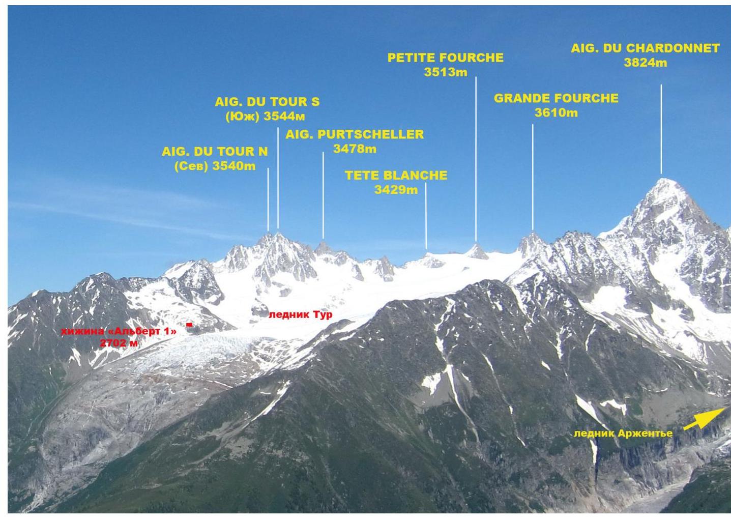
Photo of the Glacier du Tour area. Taken from Lac Blanc on July 3, 2014.
Map of the area

Approach to the Albert 1 hut

Scheme of the approach from Le Tour village to the Albert 1 hut
Almost all ascents in the Glacier du Tour area start from the Albert 1 hut. The approach can be made via two paths.
- From Le Tour village, take the two-stage cable car to the start of the trail to the hut. Then, follow the trail to the right with a relatively gentle slope, following the signs, to reach the hut. Travel time from the cable car is 1–1.5 hours.
- From the outskirts of Le Tour village, cross a large field with a small cable car towards the Glacier du Tour. From the edge of the field, the trail will start to wind its way up the left side of the rocky outcrops and glacier debris. On the rocky sections of the trail, there is red paint marking. In the middle of the ascent, there is a helicopter pad where you can rest. From there, the path continues along the moraine part of the trail. Total ascent time from the village to the Albert 1 hut is 3–3.5 hours.
General photo of the summit.

Photo of the Aiguille du Tour South and North summits. Taken from the summit of Petit Fourch. June 2014.
Labels on the photo:
- Aiguille du Tour (S) Classic route from the Albert 1 hut via the East slope, 1B category of difficulty (C.G. Heathcote, M. Andermatten, 1864)
- Aiguille du Tour (S) Route via the "colour Table" couloir, 2A–B category of difficulty [PD+ (French)](S. Cachat-Rosset, D. Samblanet, 1974)
- Aiguille du Tour (S) Route via the 3rd grade (through the "Table" gendarme), 2B category of difficulty [PD (French)](M. Dreyfus, A. and R. Duval, 1926)
- Aiguille du Tour (N) Route via the South slope (2A category of difficulty);
- Aiguille du Tour (N) Route via the Southwest ridge (3A category of difficulty)
Technical photo of the summit.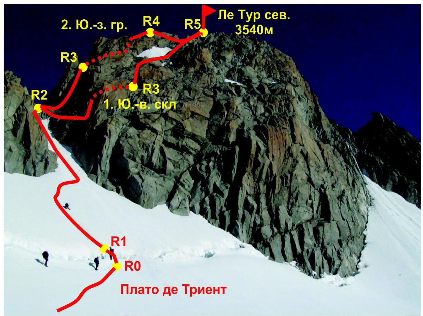
Photo of the Aiguille du Tour North summit. Taken from the Glacier (plateau) de Trient, on August 15, 2014.
Routes:
- Route 1 — via the South slope (2A)
- Route 2 — via the Southwest ridge (3A)
Description of the route sections' difficulty
| Section № | Length | Steepness | Relief characteristics | Category of difficulty | Number of pitons |
|---|---|---|---|---|---|
| R0–R1 | 7 m | 60° | Snow-ice slope, bergschrund | III | 0 |
| R1–R2 | 100 m | 30° | Snow-ice slope | II | 0 |
| R2–R3 | 50 m | 60° | Rocky slope (with snow in places) | II+ | 2 |
| R3–R5 | 50 m | 35° | Rocky slope (with snow in places) | II |
Brief description of the route passage by sections.
From the hut, move along the rocky moraine alongside the glacier, turning left. Reach the glacier. Here, it is recommended to put on climbing gear (20 minutes).
Then, along the glacier, bypassing the cirque from the left, reach the foot of the rocky Signal Reilly (2883 m). Follow the gentle glacier towards the large rusty "gates" — the approach to the Col du Tour.
- The approach to the col is via a snowy slope, squeezed between rocky ridges.
- From the col, continue moving left along the ridge (40 minutes) with a slight gain in height.
- The route begins below the bergschrund on the southeast slope of the summit.
R0–R1 overcome the bergschrund. At the beginning of summer, there are snow bridges; it may be necessary to overcome a 2–3 m snow wall.
R1–R2 ascend the snowy couloir to the ledge; movement is in linked teams, simultaneously. II 30° 100 m.
R2–R3 from the ledge, slightly pressed, traverse the southern slope, then ascend. II+ 60° 50 m
R3–R5 ascend the несложному, osypному slope to the summit. II 35° 50 m
Descent
Descent from the route is made via the ascent route.
Recommendations for the route
The route can be assessed as relatively safe. Insurance is organized without particular problems. The route is suitable for training purposes as well as for acclimatization outings. Key hazardous moments on the route:
- Movement across the glacier on the approach, with crevasses in some places!
- Large glacier area where it is easy to get lost in case of poor visibility (it is recommended to bring a GPS or compass and follow the trail)
- Snowy couloir on section R1–R2
Photo illustrations of the report
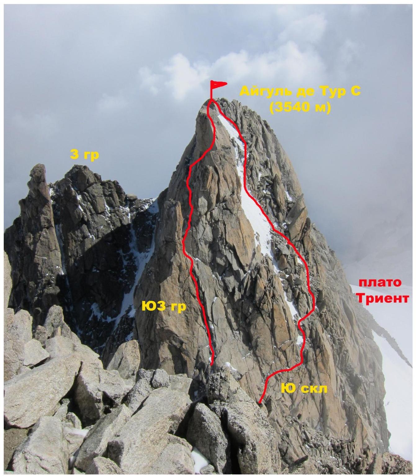
Photo of the Aiguille du Tour North summit from the South summit. Left — route via the Southwest ridge (3A), right — via the South slope (2A)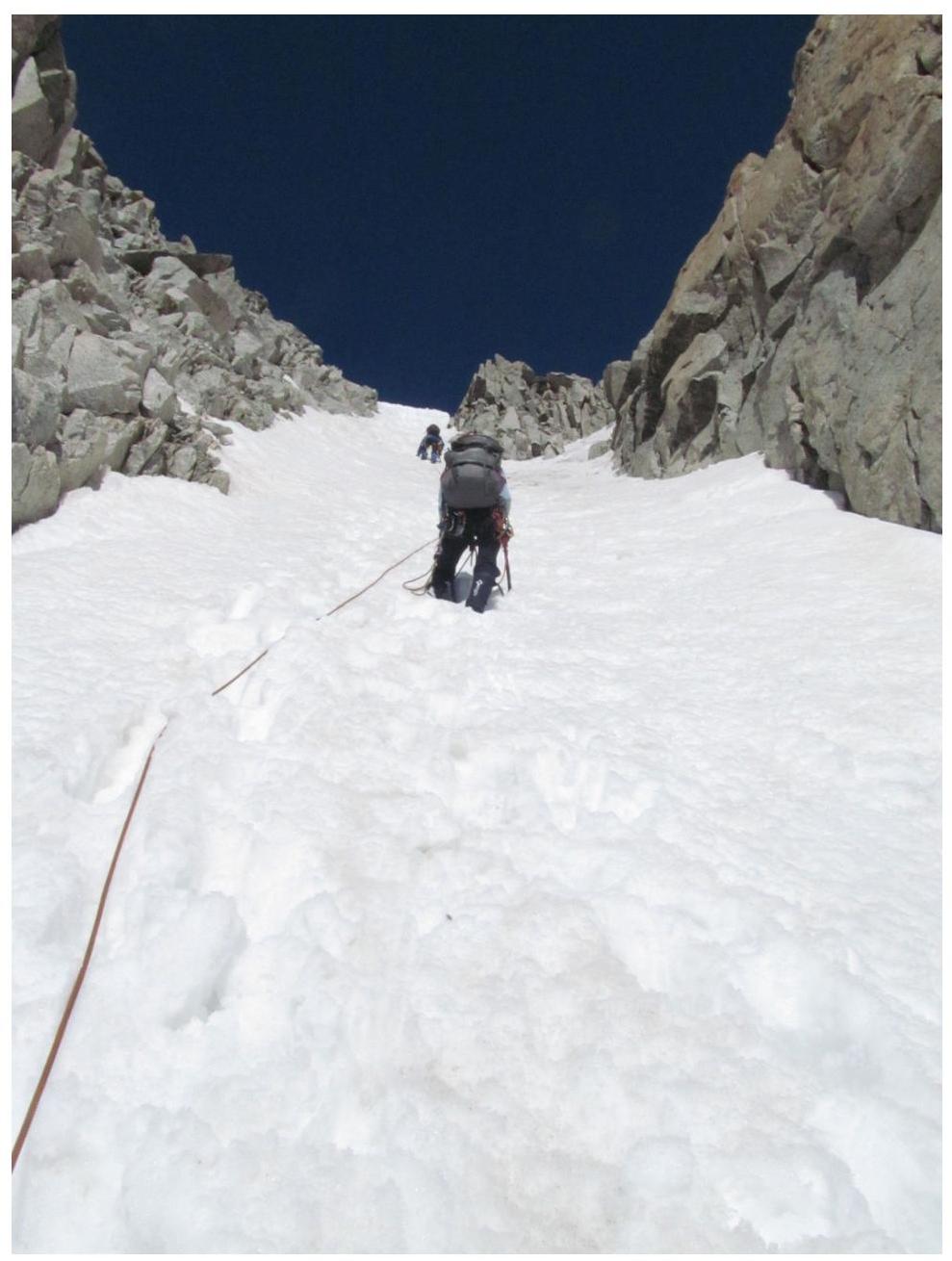
Passage of section
R1–R2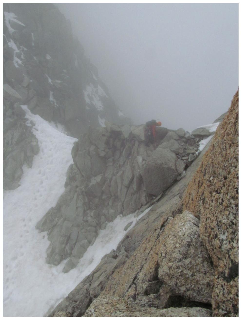
Ledge at point
R2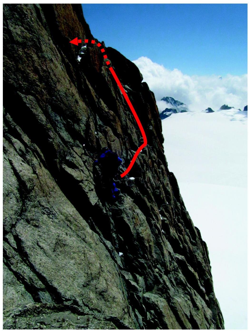
Passage of traverse section
R2–R3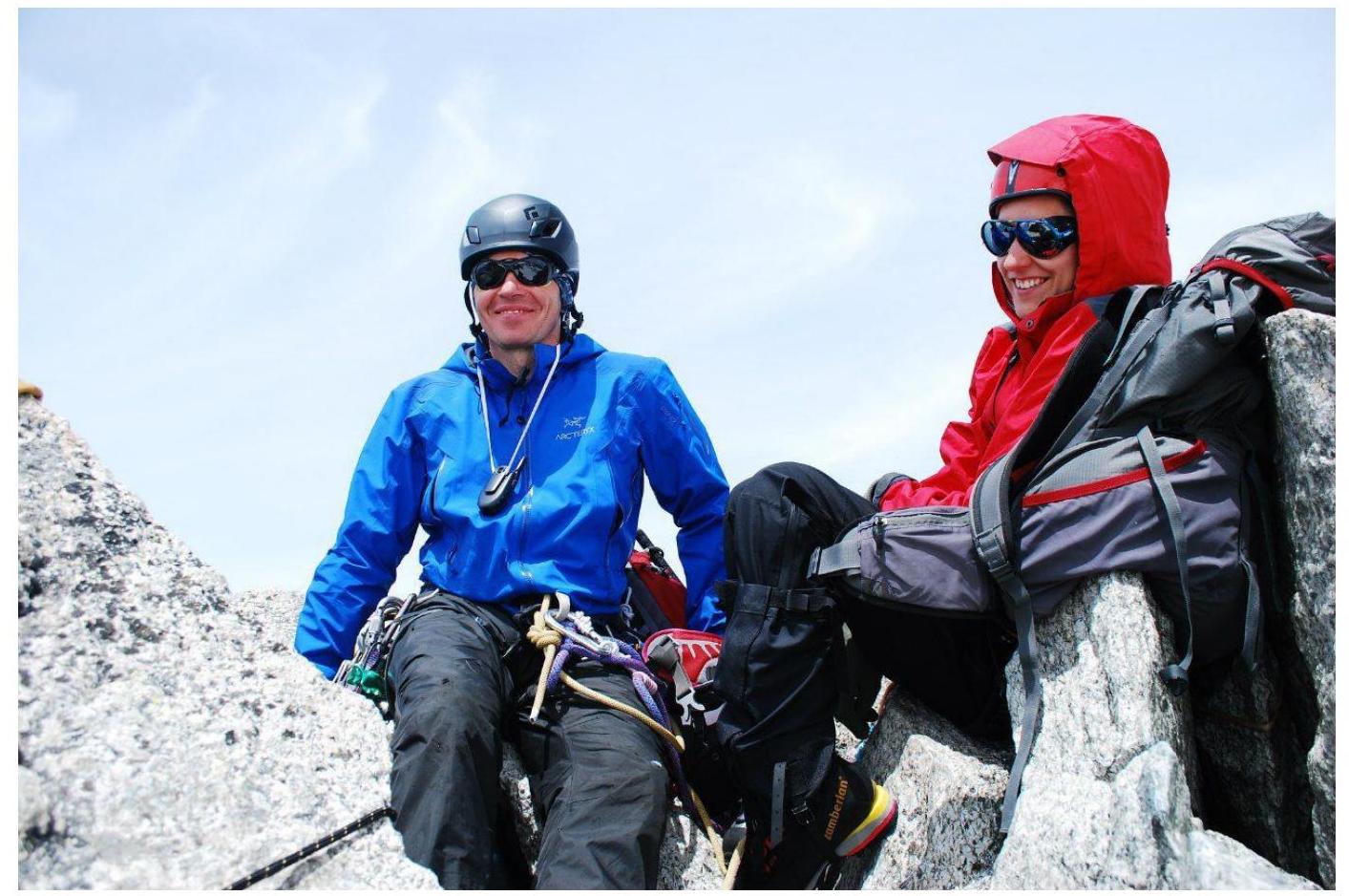
On the summit (V. Golyakov, T. Galinova)


