
MOSCOW ALPINISM CHAMPIONSHIPS 2013 IN TECHNICAL CLASS August 2013
Report on the ascent of Petit Dru (3733 m) — "American Direct" route variant, 6A category
Route Passport
-
Mountain region: Western Alps, France, Chamonix.
-
Petit Dru (3733 m), "American Direct" route variant on the western wall.
-
Approximately 6A category of difficulty (ED, 6c or ED, 6b, A1).
-
Route type: rock climbing.
-
Height difference — 1050 m, length — 1510 m.
Wall section height difference — 1000 m, wall section length — 1260 m.
Section lengths:
- V–VI difficulty category — 745 m.
-
Pitons left on the route: total — 0.
Equipment used on the route:
- bolted stationary — 40 pcs., including 9 pcs. for artificial climbing aids (ITOs);
- rock pitons — 12 pcs., including 4 pcs. for ITOs;
- chocks — 65 pcs., including 10 pcs. for ITOs;
- cams — 121 pcs., including 18 pcs. for ITOs;
Total ITOs used — 41 pcs.
-
Climbing hours to the summit:
- Day 1: 5 hours;
- Day 2: 13 hours;
- Day 3: 9 hours;
- Day 4: 11 hours;
- Day 5: 3.5 hours.
Total: 41.5 hours. Overnight stops:
- 1st on a ledge, reclining;
- 2nd on a large rock block, reclining;
- 3rd on a rock ledge, reclining;
- 4th on a rock shelf, reclining.
-
Ascent made by a team of two: Kozhevnikov Alexey, Murga Sergey.
-
Coach: Nasedkin Oleg Yuryevich — Candidate Master of Sports.
-
Exit to the route:
- Exit from Base Camp: August 10, 2013, 08:00.
- Start of the route: August 10, 2013, 14:00.
Summit: August 14, 2013, 10:30. Descent to the glacier: August 14, 2013, 18:00.
-
Organization: Zelenograd Sports Club of Alpinism and Rock Climbing.
Tactical Actions of the Team
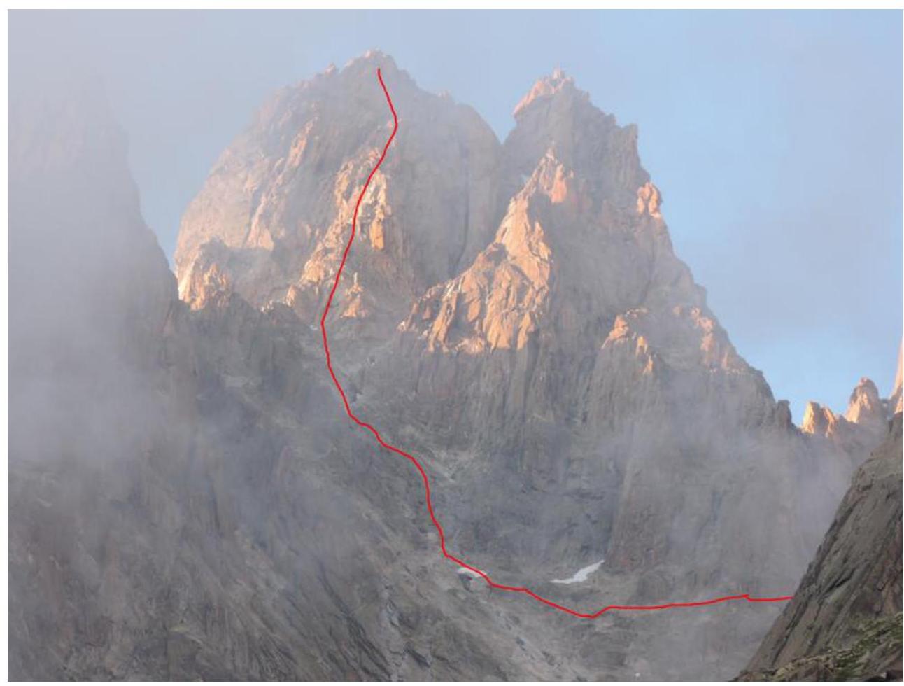
The route can be divided into three parts.
Lower part — 8 ropes, maximum V+, 300 m. This part of the route can be actively affected by falling rocks, so it has many bolts, which speeds up the passage.
Middle part — the most challenging. Length — 13 ropes, several sections of VII, 500 m to the overnight stop. The crux of the route — 120 m:
- 40 m immediately after the overnight stop, IV+;
- 80 m along the internal corner, VII+/VIII− or A1.
After the crux, a transition to the northern wall was made using old bolts — 30 m, A1. The total length of the middle part is 650 m.
The third, upper part of the route:
- Ascent along the right edge of the northern wall for 310 m to a hole in the wall, then transition to the southern wall. Maximum difficulty — V+, characterized by climbing on broken rocks, partially iced;
- Transition to the southern wall;
- Traverse along the southern wall to the east — 180 m (III category of difficulty);
- Ascent to the summit — 70 m (IV+ category of difficulty).
The total length of the upper part of the route is 560 m.
On August 10 at 12:00, the team of two reached the start of the route. The weather was good, and the mood was excellent, so it was decided to start climbing immediately.
To approach the start of the route, it is necessary to:
- Cross a snow slope with a slope angle of up to 45°
- Wear crampons and carry an ice axe
A few ropes from the start, a ledge for an overnight stop is visible. The lower bastion is well-equipped with bolts, so little personal equipment is needed. This equipment allows for a quick passage through the lower section, which is prone to rockfall, and to approach the wall.
Directly under the wall, a small tent was set up, and a relatively comfortable overnight stay was achieved. Camp 1 — end of section R9.
On August 11 at 07:00, the team started moving upwards. On the same day at 20:00, they stopped for the night at the designated spot — on a large rock block. Camp 2 — end of section R20.
The next day, August 12, the team was slightly delayed in starting the route (another team was ahead). They climbed the key 80-meter internal corner and moved to the northern wall using old bolts (after rockfalls on the western wall, it became dangerous to continue the "American Direct" route via the classic path).
After moving to the northern wall, an unscheduled bivouac was organized — there was a high risk of not reaching the planned overnight spot before dark. Camp 3 — end of section R24.
On August 13 at 8:00, the team started moving upwards. At 15:00, they climbed through a hole in the wall to the southern side. Before dark, they searched for a passage to the summit but were unable to find one due to low visibility in heavy fog. They organized a bivouac. Camp 4 — end of section R32.
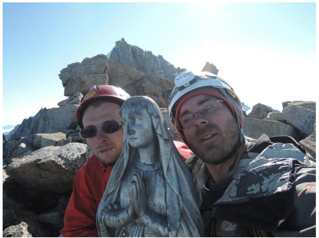
On August 14 at 07:00, the team again set out to find the summit. At 10:30, they reached the summit.
To find the summit:
- From the hole in the ridge, traverse along "quartz" ledges to the east
- Move approximately 180 m, almost to the couloir between Petit Dru and Grand Dru
- Then, using internal corners and walls, crossing a small snow patch, ascend to the summit
At 13:00, the team began their descent from the bivouac site. The descent was made along the southern wall using numerous rappel points. A total of about 14 rappels were made. At 18:00, they descended to the glacier and reached the moraine near the refuge. The first climber in the team worked without a backpack on challenging sections and with a small backpack containing personal items on easier sections. Belaying was done with a double rope (twin). The team was equipped with:
- a first-aid kit,
- communication means,
- all necessary bivouac gear.
The equipment set was standard for rock climbing routes. A wide range of chock sizes was used, up to #3 camalot (double sizes of Black Diamond camalots #2, #1, #0.75). Rock pitons were used once. It is possible to climb without rock pitons. Ice screws were not used. For artificial climbing aids, one lightweight ladder was used.
Ropes:
- Two dynamic ropes, 8.7 mm, 50 m each.
The crux of the route (80-meter internal corner after Camp 2) and the transition to the northern wall were climbed using artificial climbing aids (sections R22–R24). The rest of the route was climbed using free climbing.
There were no falls or injuries. During the ascent, two deviations from the tactical plan occurred.
- On August 12, the team stopped for a bivouac early after the crux. This was dictated by the need to rest and uncertainty about reaching the planned bivouac spot before dark — the topo and description of the upper part available to them were very scarce. During the ascent, it became clear that bivouacs could be organized at the end of sections R27, R28.
- On August 13, the team was unable to immediately find the passage to the summit.
Despite deviations from the tactical plan, the ascent was completed with a sufficient margin of safety. The amount of food and fuel was calculated with a small reserve.
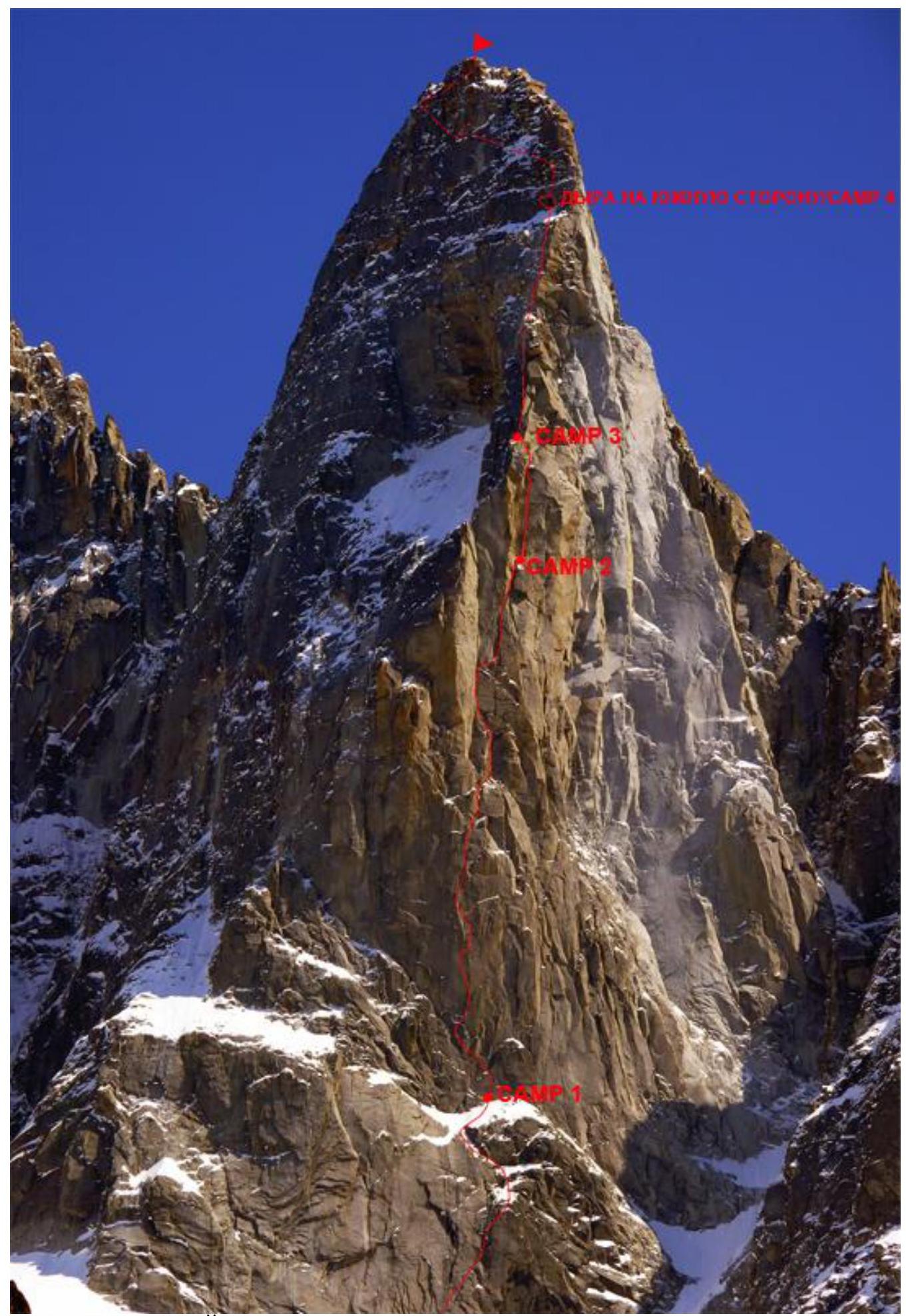
PHOTO TAKEN FROM THE SITE http://www.summitpost.org ↗
Upper part of the route
Average slope 70°, length 310 m.
Middle part of the route
Average slope 80°, length 650 m.
Lower part of the route
Average slope 70°, length 300 m.
Description of the route by sections
| Section # | Length, m | Chocks | Pitons | Cams | UIIA | Difficulty | Slope angle, degrees |
|---|---|---|---|---|---|---|---|
| R0 | 60 |  | II | 30 | |||
| R1 | 45 | 2* | 2 |  | IV | 70 | |
| R2 | 35 | 2* |  | III | 30 | ||
| R3 | 45 | 7* | 1 |  | V+ | 80 | |
| R4 | 45 | 6* |  | V | 75 | ||
| R5 | 45 | 7* |  | V+ | 80 | ||
| R6 | 35 | 4* |  | IV+ | 70 | ||
| R7 | 50 | 3* | 2 | IV | 65 | ||
| R8 | 10 | II | 40 | ||||
| R9 | 35 | 3 | 4 | V | 75 | ||
| R10 | 50 | 4 | 2 | V+ | 80 | ||
| R11 | 45 | 3 | 2* | 6 | VII | 90 | |
| R12 | 40 | 4 | 5 | V+ | 85 | ||
| R13 | 40 | 3 | 5 | V+ | 85 | ||
| R14 | 45 | 3 | 1* | 7 | VII | 85 | |
| R15 | 40 | 4 | 1* | 6 | VII | 85 | |
| R16 | 40 | 3 | 5 | V+ | 70 | ||
| R17 | 35 | 2 | 4 | IV+ | 75 | ||
| R18 | 40 | 3 | 5 | V | 75 | ||
| R19 | 45 | 2 | 4 | V+ | 80 | ||
| R20 | 45 | 3 | 4 | IV+ | 75 | ||
| R21 | 40 | 2 | 3 | IV | 70 | ||
| R22 | 40 | 6 | 2* | 10 | VI/A1 | 90 | |
| R23 | 40 | 4 | 2 | 8 | VI/A1 | 90 | |
| R24 | 30 | 9* | 2 | V/A1 | 90 | ||
| R25 | 45 | 2 | 7 | IV+ | 70 | ||
| R26 | 45 | 3 | 5 | V | 75 | ||
| R27 | 35 | 2 | 6 | V+ | 80 | ||
| R28 | 50 | 2 | 4 | IV | 60 | ||
| R29 | 30 | II | 20 | ||||
| R30 | 45 | 3 | 4 | IV+ | 70 | ||
| R31 | 45 | 2 | 4 | IV | 55 | ||
| R32 | 15 | III | 30 | ||||
| R33 | 180 | 4* | 2 | III | 15 | ||
| R34 | 40 | 2 | 2 | IV+ | 60 | ||
| R35 | 30 | 2 | III | 40 |
* Marks points left by previous climbers on the route.

CAMP 2
Crux section after CAMP 2
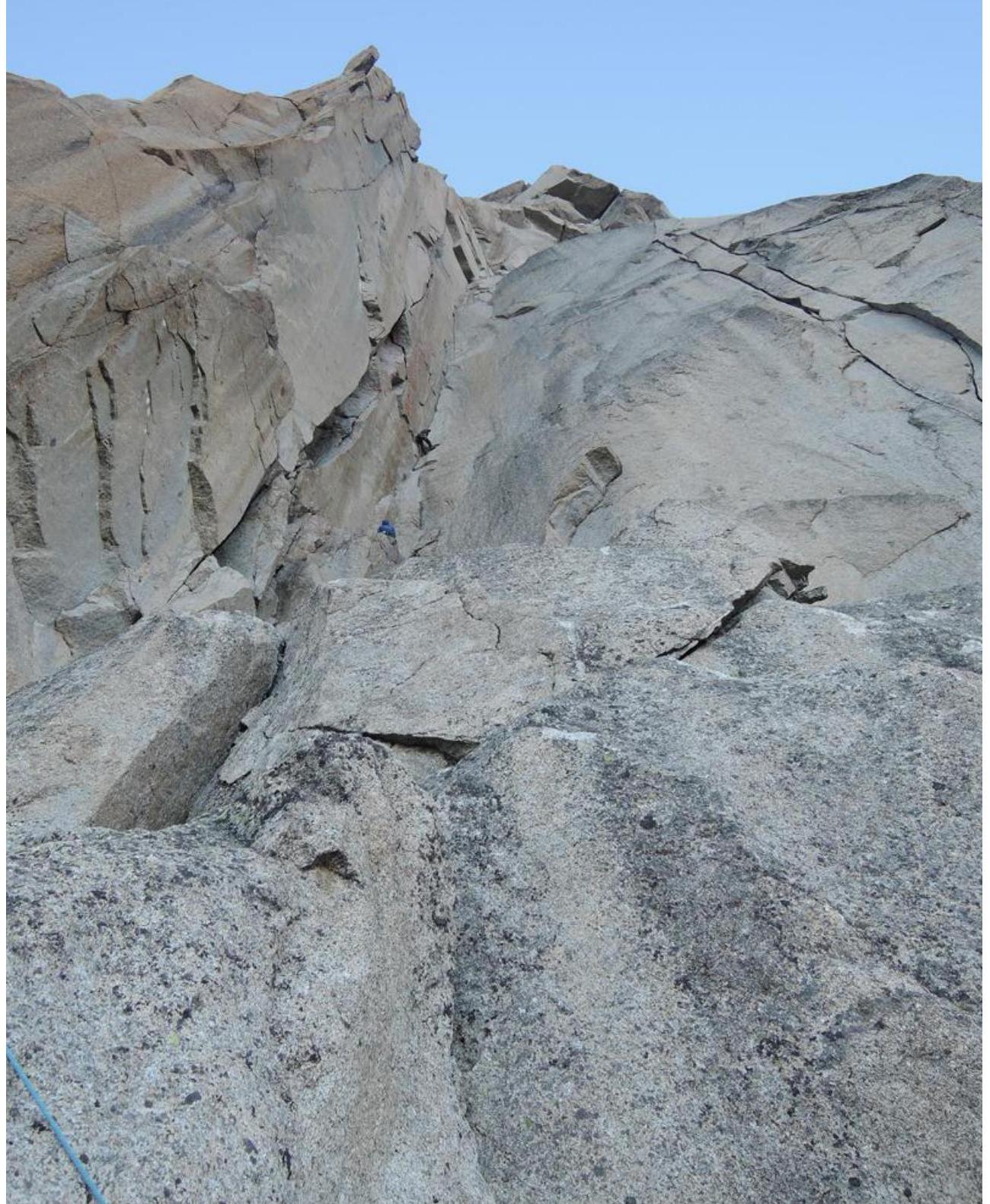
Useful information for the descent. From the hole connecting the northern and southern sides, approximately 100 m along the "quartz" ledge, on a local loop, we begin the descent. The main landmark is the ridge to the right of the descent direction. The main effects — not to go right beyond it, as the western wall is there, and after rockfalls, it has become very dangerous. After descending to the talus (right is a sharp ridge that should be avoided), continue the descent along the talus-filled couloir, which then becomes quite narrow and has a powerful water flow at the bottom. The rappel stations are initially located in the center, then they shift to the LEFT side of the couloir.
After reaching a gentler slope (there is a small snow patch and some grass appears), we turn left. The belay is simultaneous, the terrain consists of talus shelves, and, turning around a large boulder — the edge of the southern wall, we reach a good trail that leads to the glacier. The glacier is closed, so it is recommended to wear crampons and carry an ice axe to cross it.
Comments
Sign in to leave a comment