Passport
- Winter category.
- France, Alps, Mont Blanc massif.
- Grand Capucin peak, 3838 m, via the East face. Route "Russkaya zima" (Russian Winter).
- Proposed category — 6A, first ascent.
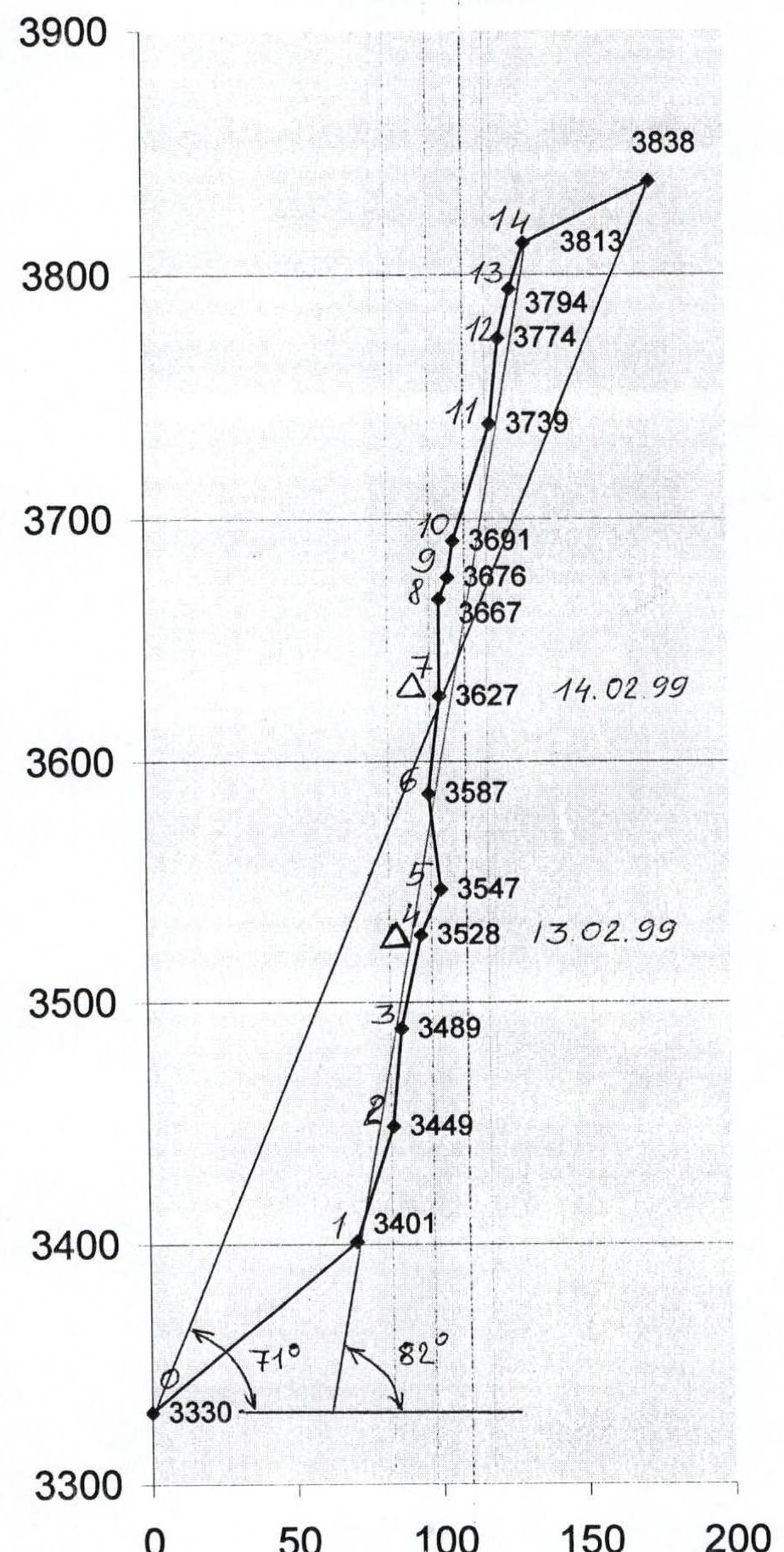
- Height difference — 508 m, length — 570 m, including wall section 413 and 420 m, respectively.
Length of sections with 5th category difficulty — 30 m, 6th category difficulty — 390 m. Average steepness of the wall section 82°, from bergschrund to summit 71°.
- Pitons driven: rock bolts, pitons, ice screws
| 42 | 230 | 0 | 0 |
|---|---|---|---|
| 30 | 180 | 0 | 0 |
Left on the route: rock — none, chocks — none.
- Team's climbing hours — 22, days — 3.
- Overnight stays: both on a platform.
- Participants: Klenov Alexander Valerievich, MSMS (Master of Sports of International Class), home address: 620144, Yekaterinburg, Sheinkmana st., 128, apt. 125.
Davi Mikhail Marenglenovich, MSMS, home address: 620137, Yekaterinburg, Blyukhera st., 49, apt. 70.
- Coach: Ostanin Victor Vasilyevich, MS (Master of Sports)
home address: 620003, Yekaterinburg, Rodonitovaya st., 30, apt. 120.
- Route start: February 13, 1999.
Summit: February 15, 1999. Return: February 16, 1999.
- Organization: Committee for Physical Culture and Sports of Sverdlovsk Region. 620151, Yekaterinburg, Malysheva st., 60.
IIème Rassemblement International d'Alpinisme Hivernal
Nouvelle voie
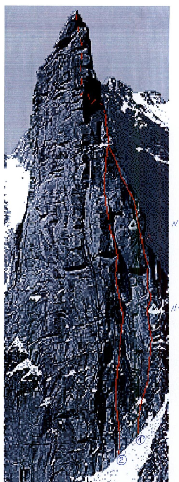
Face NE du Grand Capucin — «Hiver Russe» Photo JC. Marmier
Grand Capucin
3838 м — France — Massif du Mont Blanc «Russkaya zima» «Hiver Russe»
1re ascension: Mikhail DEVI et Alexandre KLENOV from February 13 to 15, 1999. Difficulté : ED — 400 м (12 longueurs jusqu’à 50 м) — A3/6С maximum — Tout le matériel a été récupéré. Accès : depuis la France par le téléphérique de l’Aiguille du Midi et le refuge des Cosmiques ou depuis l’Italie par le refuge Torino. On accède facilement au pied de la Face. Descente : Les premiers ascensionnistes sont descendus en 11 rappels dans la voie.
Malgré les très importantes chutes de neige qui marquent le début du mois de Février sur les Alpes, le team «Russian Big Wall Project» profite du premier créneau de beau temps pour prendre de l’altitude. Après d’аprés discussions autour de flacons aux effluves enivrantes, c’est le Grand Capucin (Massif du Mont Blanc) qui est choisi pour cible. Décidément, le second Rassemblement International d’Alpinisme Hivernal démarre sur les chapeaux de roue…
Rp. Alexandre Klenov — Mikhail Devi
Haut de page / Expe.com / Rassemblement

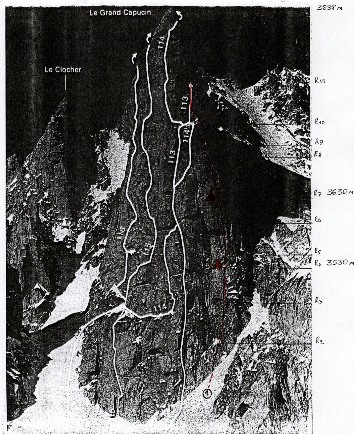
General photo of the summit.
-
- Team's route
-
- Ruchkin – Zaimov's route
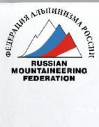
Photopanorama of the area
Grandes Jorasses 4200 m Dent du Géant 4013 m Grand Capucin 3838 m Mont Blanc de Tacul 4248 m
Photo taken from Aiguille du Midi, 3842 m, February 12, 1999.
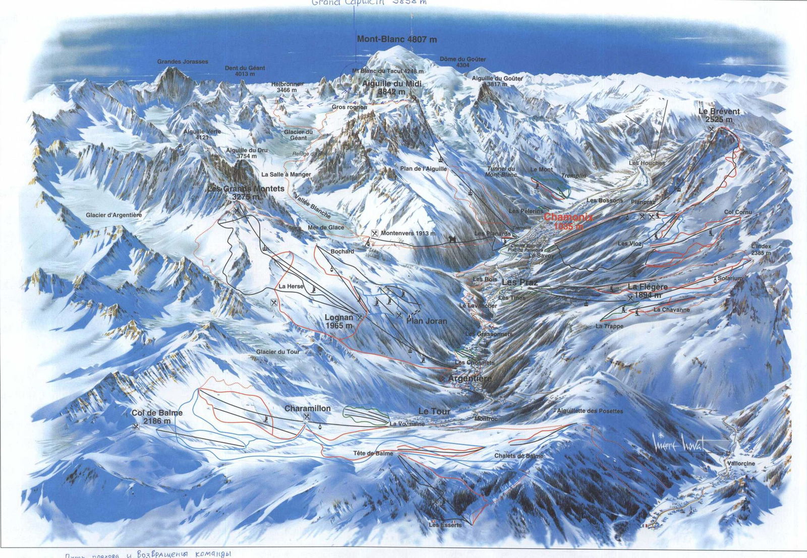
A place of your preference...
The Mont Blanc mountain, enchanting and intimidating, has become, thanks to its slopes, a symbol of a fabulous massif for daring climbers, scientists, writers, and poets who have admired it, and a welcoming valley.
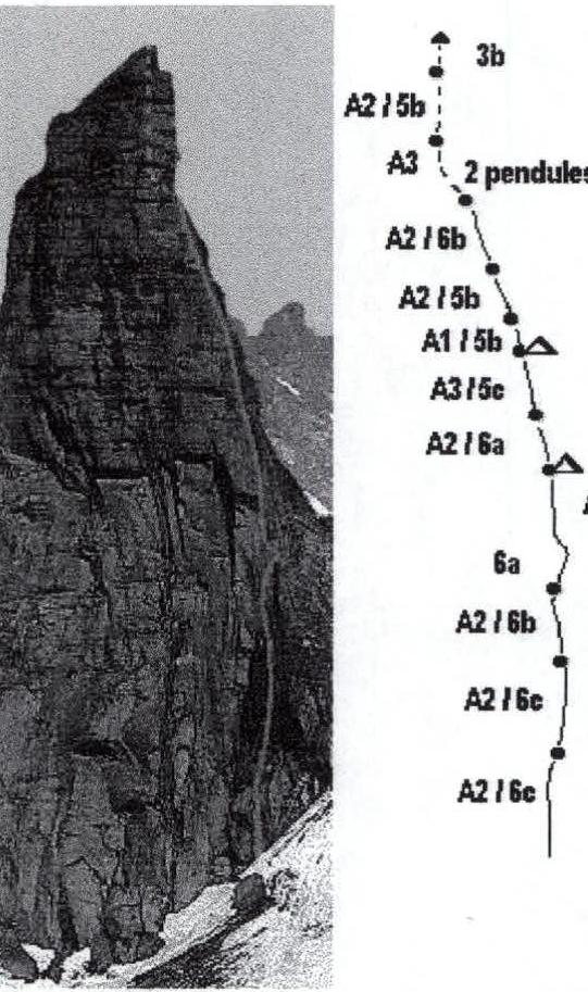
Route profile
Tactical actions of the team
The team's tactical actions were based on previous experience of wall ascents, as well as the specifics of this ascent. The steep monolithic rocks of Grand Capucin in conditions of severe frost and gusty winds could only be climbed by technically prepared climbers with a sufficient supply of equipment and warm clothing. Regular training on artificial and natural climbing walls, the level of "free climbing" 7A–7C allowed the team to overcome a significant part of the route by free climbing, which in these conditions would be beyond the capabilities of weaker climbers. A tent with a self-made platform was constructed, allowing for a "roof over their heads" and satisfactory rest, regardless of the terrain and weather conditions.
The team's movement was organized as follows. The first climber moved without a backpack on a double rope (both — "1" UIAA), one of the ropes was fixed as a handrail. The second climber moved along the handrail with a backpack and platform with top rope protection, while the first climber pulled up another backpack connected to the second climber with a short piece of rope. Each day, the lead climber was changed, allowing for an even distribution of the ascent load. The nutrition regime included hot food in the morning and evening, with a snack during the day.
Throughout the entire route, there was radio communication with the Ruchkin – Zaitov team, and if necessary, there was the possibility of calling a professional rescue team from Chamonix.
Knowing the instability of the weather recently and having a favorable weather forecast for only three days, the team had previously worked out the possibility of returning after descending from the wall towards Italy, examined the return route, and had a map and compass.
All of the above allowed the team to complete a complex first ascent in difficult conditions with a sufficient margin of strength and safety and in good style.
Route diagram in UIAA symbols
M 1:2000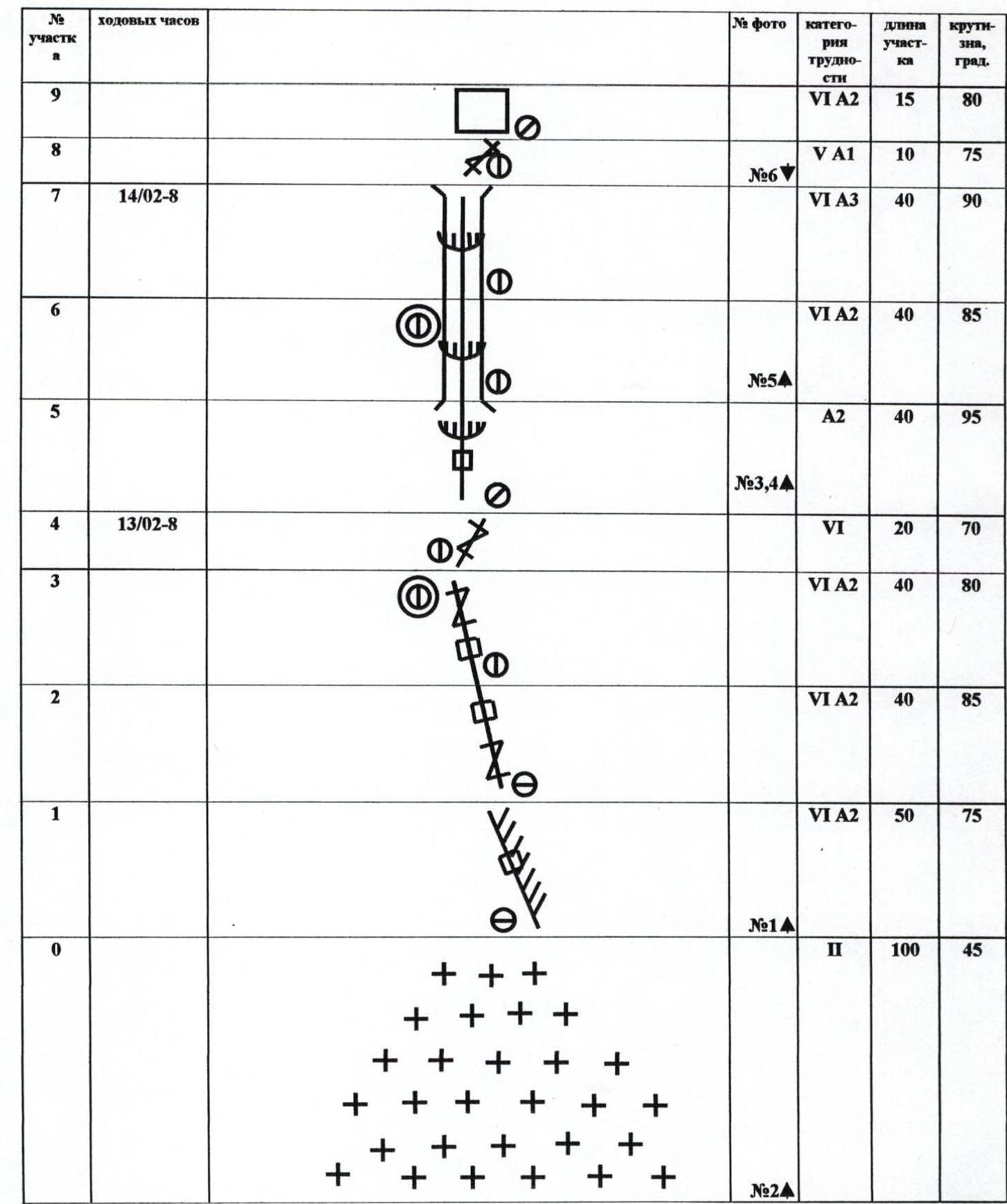
| Section № | Climbing hours | Photo № | № (P10) | Difficulty category | Section length | Steepness, degrees |
|---|---|---|---|---|---|---|
| 14 | Total to summit – 22 15/02–6 |  | № 8 | III | 50 | 30 |
| 13 | V+ | 20 | 75 | |||
| 12 | A2 | 20 | 80 | |||
| 11 | VI A3 | 35 | 85 | |||
| 10 |  | VI A2 | 50 | 75 | ||
| 9 | VI A2 | 15 | 80 | |||
| 8 | V A1 | 10 | 75 | |||
| 7 | 14/02–8 | № 6 | VI A3 | 40 | 90 | |
| 6 | VI A2 | 40 | 85 | |||
| 5 | № 5 | A2 | 40 | 95 | ||
| 4 | 13/02–8 | № 3, 4 | VI | 20 | 70 | |
| 3 | VI A2 | 40 | 80 | |||
| 2 | VI A2 | 40 | 85 | |||
| 1 | VI A2 | 50 | 75 | |||
| 0 | № 1 | II | 100 | 45 |
Route description by sections
Section R0. Steep slope covered with deep snow, with several crevasses. Initially traversed without a backpack, digging a trench. Section R1. On artificial terrain (ITO) along a crack to the right of a blind internal corner. At the end of the section, exit to a snowy ledge under a monolithic wall. Section R2–R3. Along a thin crack to the left of the largest crack, upwards and to the left, using ITO and difficult climbing. A small snowy ledge for overnight stay. Section R4. To the right and upwards by climbing. Section R5. To the left and upwards on ITO to a large cornice, overcome along the left crack. Section R6–R7. Upwards along a cleft, overcoming two cornices, second overnight stay (possible only on a platform). Section R8. To the right and upwards by climbing to an edge. Section R9. To the left and upwards on ITO and climbing to a large snowy ledge. Section R10. Cornice with a crack, then a slab with a cleft for large cams and a bit more, exits to the north wall. Section R11. Traverse to the right, then along cracks and flakes upwards, two pendulum movements from crack to crack. Section R12. Straight up on ITO, then pendulum to the left. Section R13. Climbing to the right and upwards. Section R14. Traverse to the right of the ridge in crampons. Exit to the summit from the western side.
Technical photo of the route 1 — team's route
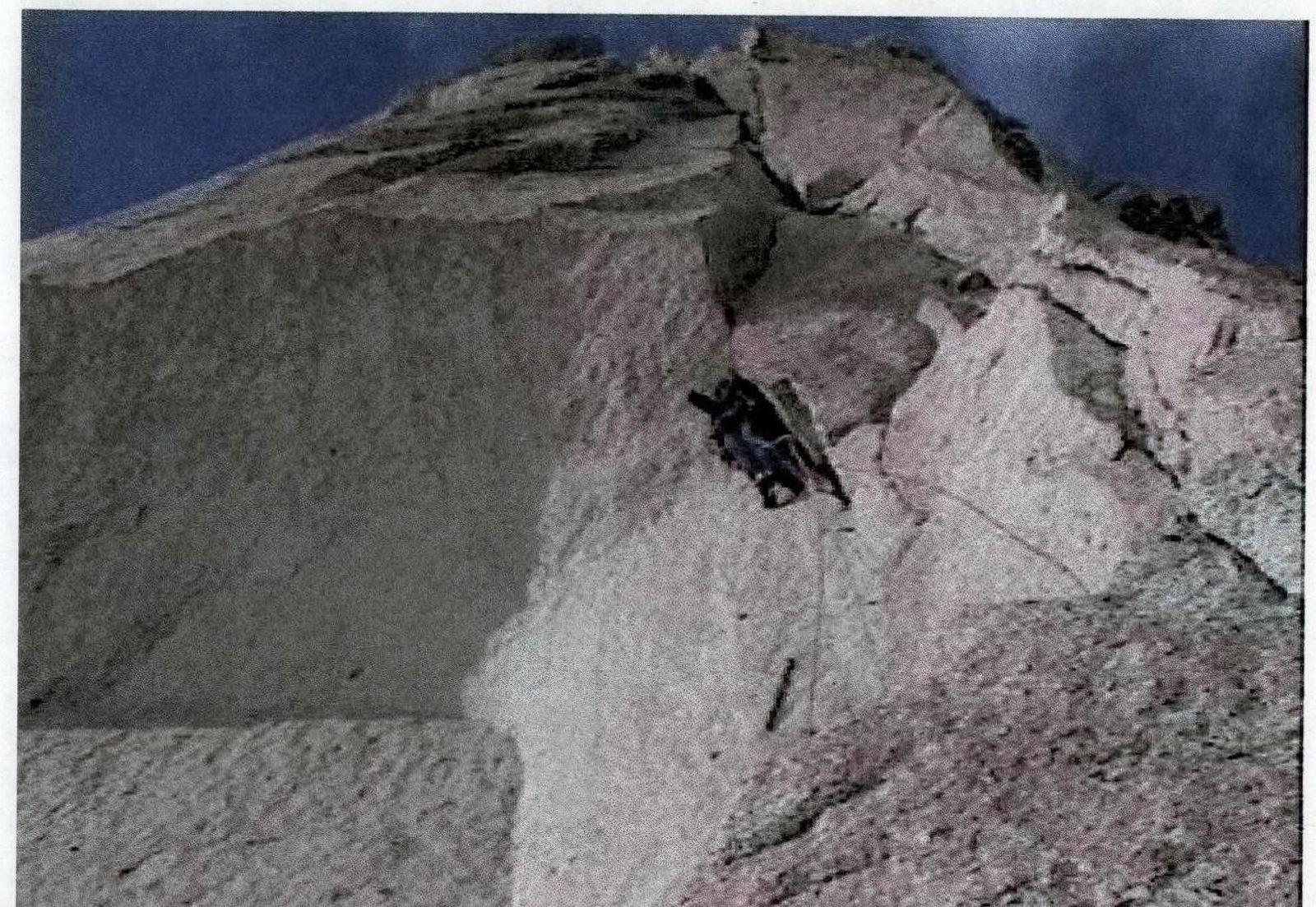
Photo 3. Cornice on section R5.


