
Map diagram

General photo of the summit. Routes from left to right:
- 1 — team's route
- 2 — English route 87 (Saunders, 1987)
Description of the Climbing Area
Spantik or Golden Peak is located in the second-highest mountain system in the world — Karakoram, which directly continues Hindukush, rising between Pamir and Himalayas. In particular, the road that leads to the climbing area passes directly through the junction of the three greatest mountain systems in the world:
- Himalayas
- Karakoram
- Hindukush
This territory is currently controlled by Pakistan, although it is disputed with India.
A fairly convenient transport route lies through Tashkent, which we chose to get to our destination. By plane from Yekaterinburg — Tashkent — Lahore, then by comfortable DAEWOO-EXPRESS bus to Islamabad, where a minibus was waiting for us under an agreement with a local firm. The road further follows the Karakoram Highway to Karimabad, where the minibus is replaced by jeeps (easily rented on the spot), which deliver to the last settlement — Hoppar village. The journey from Islamabad to Hoppar takes two days. From Hoppar with a caravan of porters (hired from the village residents) it takes another two days to reach the base camp. The trail, not very good (the area is not frequently visited), immediately crosses a huge glacier from the village, and then winds along its right (orographic) side in the lateral moraine pockets, coming out onto the glacier a couple of times. The distance from Hoppar to the base camp, located at an altitude of 4500 m, is about 30 km.
The climate of this area is sharply continental. At an altitude of 3500 m, the average temperature in July is +16 °C, and in January -8 °C. Climbing season — from May to September. Gradual warming by mid-summer, on the one hand, facilitates climbing conditions, but on the other hand — snow avalanches. From dry (up to 6000 m) they turn into wet ones, which are much more dangerous, and rockfall danger on combined routes increases.
The population consists of local ethnic groups Ladakhi, Balti, Hunza, Brokpa — close to Tibetans. The attitude of local residents is quite friendly, but they never miss their advantage.
The animal world of the mountains is very diverse, and the mountain rocks are rich in various minerals, crystals of which are happily traded by local residents.
In conclusion, I would like to say that besides the well-known peaks of Karakoram, there are many mountains from 7000–7800 m, which are not only unconquered, but even unexplored and await their climbers.
Route Profile

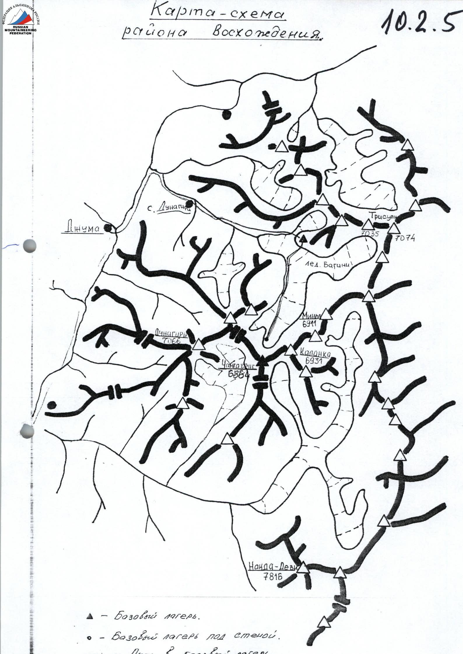
Map diagram of Garhwal Himalayas region.

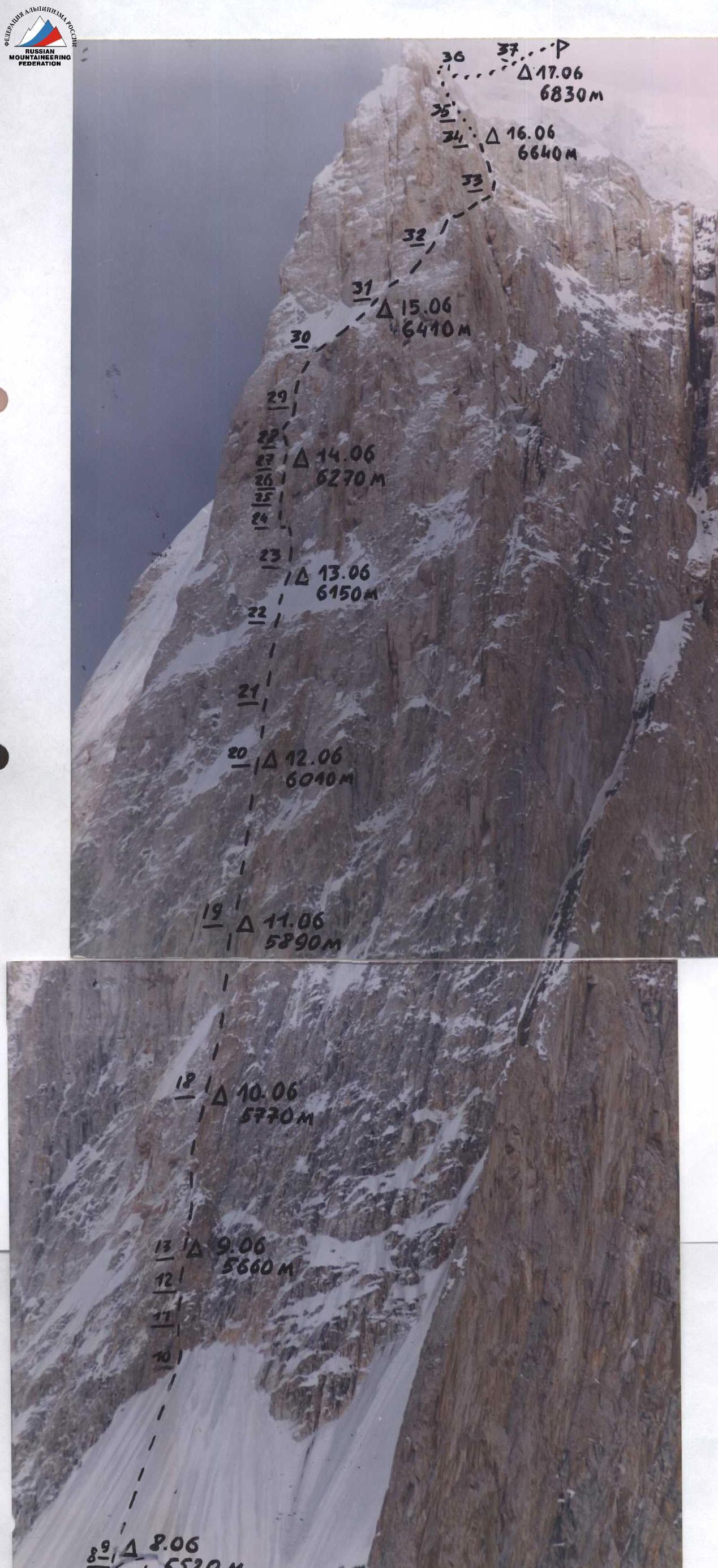

Route Diagram in UIAA Symbols
M 1:2000 (Sections over 100 m and less than 10 m are not to scale)
| Section № | Description | Symbols | Photo № | Diff. Cat. | Section Length | Steepness, ° |
|---|---|---|---|---|---|---|
| 0 | Rock-1 | ++++++ | I | 300 | 40 | |
| 1 | Ice-4 | ++++++ | №1 | III | 50 | 50 |
| 2 | Axe-10 | +++++++++ | II | 500 | 45 | |
| 3 | Ice-3 Rock-2 | ++++++ | III | 100 | 50 | |
| 4 | Rock-2 Piton-4 | +++ | IV | 40 | 60 | |
| 5 | ++++++ | I | 200 | 20 | ||
| 6 | Ice-2 | ++++++++++ | II | 120 | 45 | |
| 7 | Ice-2 | +++ TRAVERSE LEFT ALONG BERGSCHRUND | VI | 2 | 120 | |
| I | 30 | |||||
| 9 | Ice-10 | +++++++++++++++ | III | 110 | 45 | |
| 10 | Rock-4/2 Piton-5/3 | □+ | №2 | VI A2 | 20 | 70 |
| 11 | Rock-3/1 Piton-4/2 | □+ | V+A1 | 30 | 50 | |
| 12 | Rock-4/2 Piton-5/3 Ice-2 | +□+ | VI A2 | 25 | 60 | |
| 13 | Rock-10/4 Piton-15/9 Ice-3/3 | ++++ | VI A2 | 120 | 70 | |
| 18 | Rock-11/4 Piton-16/8 Ice-2 | +++ | №3 | VI A2 | 120 | 75 |
| 19 | Rock-10/4 Piton-15/9 Ice-3/2 | +[]+ | №4 | VI A2–A3 | 120 | 80 |
| 20 | Rock-4 Piton-5 Ice-2 | +0 | VI | 40 | 70 | |
| 21 | Rock-6/4 Piton-10/7 Ice-2/1 | (symbols) | VI A2 | 70 | 85 | |
| 22 | Ice-2 | (symbols) | II | 50 | 45 | |
| 23 | Rock-3 Piton-8 | V+ | 40 | 60 | ||
| 24 | Rock-11/10 Piton-18/16 | A3 | 40 | 95 | ||
| 25 | Rock-4 Piton-7 | VI | 50 | 75 | ||
| 26 | Rock-3 Piton-6 | (symbols) | VI | 20 | 80 | |
| 27 | Rock-2 Piton-4 | №5 | VI | 20 | 70 | |
| 28 | Rock-9/8 Piton-12/11 | (symbols) | №6 | A3 | 30 | 95 |
| 29 | Rock-5 Piton-8 | VI | 40 | 75 | ||
| 30 | Ice-2 | +++++ | II | 50 | 40 | |
| 31 | Rock-9/4 Piton-13/7 | (symbols) | VI A2 | 100 | 75 | |
| 32 | Rock-2 Ice-3 | (symbols) | III | 40 | 45 | |
| 33 | Rock-6 Piton-12 | (symbols) TRAVERSE ALONG SLANTING SHELVES | IV–V | 120 | ||
| 34 | Rock-7/4 Piton-10/7 | (symbols) | VI A1 | 50 | 75 | |
| 35 | Ice-3 | (symbols) | III | 50 | 45 | |
| 36 | ++++ | I | 600 | 20 | ||
| 37 | (symbols) | №7 | II | 400 | 30 |

Photo 1. Section R1.
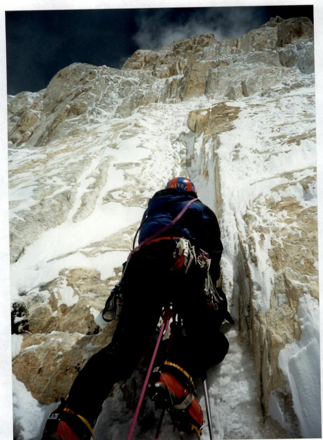
Photo 2. Section R11.

Photo 3. View down from the bivouac to sections R2–R13.

Photo 4. Section R19.
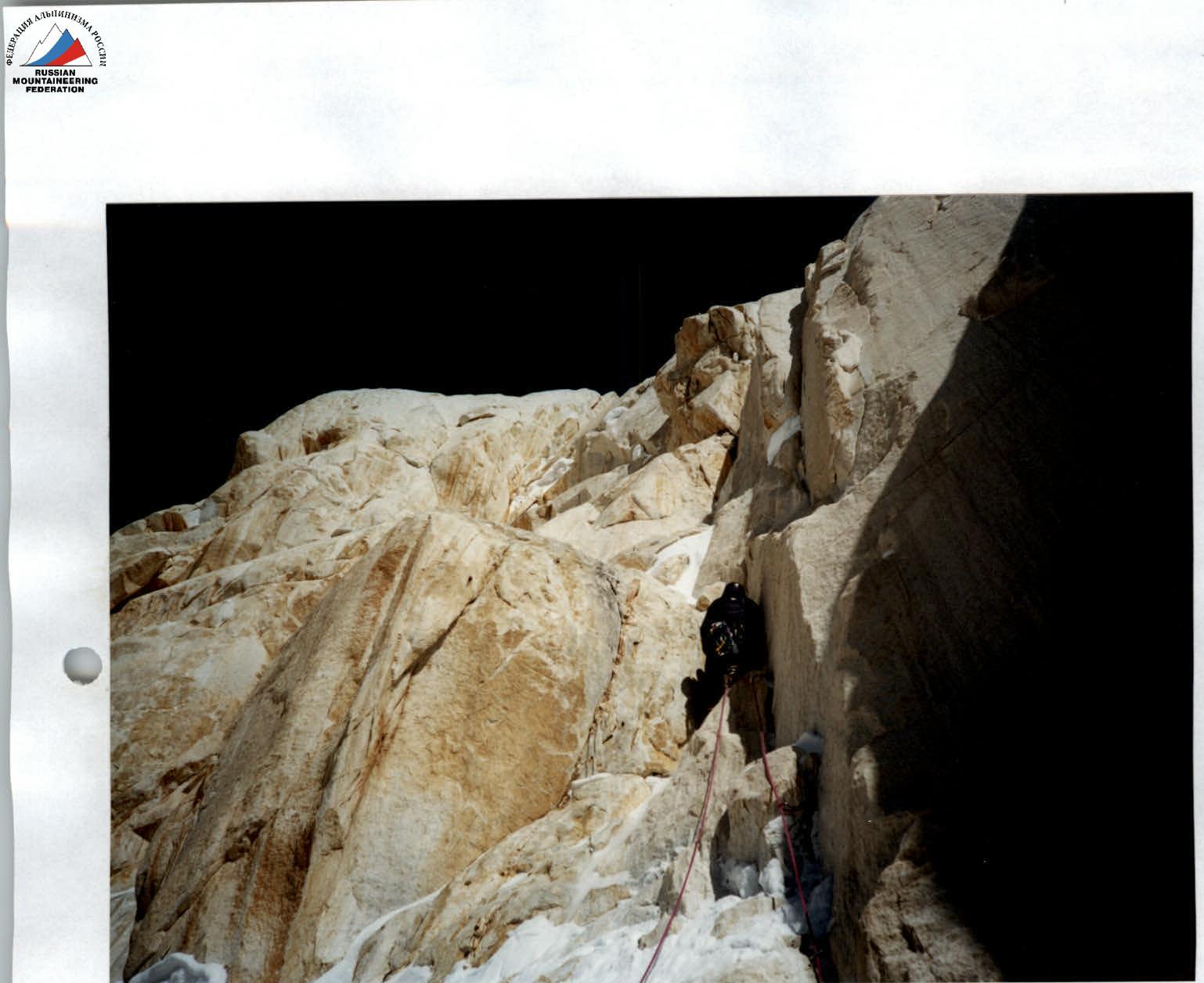
Photo 5. Section R27.
Comments
Sign in to leave a comment