
Ascent Report
Within the framework of the Russian mountaineering championship. High-altitude-technical class.
Shtyk–Nozh Peak (2540 m)
- North counterfort of the "Shtyk" bastion
- East edge
Route 6A cat. diff. (proposed), first ascent, first ascent. Ikatsky Ridge, Barguzin River valley, 9.9.
Team Leader: Klepikov A.A. Participants: Ilyinsky V.A.
Ascent Passport
- Ikatsky Ridge, Barguzin River valley, 9.9.
- Shtyk–Nozh Peak (2540 m), via N counterfort of "Shtyk" bastion and E edge.
- Proposed — 6A — first ascent, first ascent.
- Route character: combined.
- Route height difference: 650 m.
- Route length: 1238 m.
Height difference of the main route section: 600 m. Length of the main route section: 913 m. Section lengths: V–VI cat. diff. — 636 m, including:
- VI cat. diff. — 204 m
- V cat. diff. — 432 m
- IV cat. diff. — 340 m
Average steepness of the main section: 67° degrees. Average steepness of the key wall section: 76° degrees (410 m height difference).
- Pitons left on the route:
total: 4; including bolted: 4.
Total used on the route:
- bolted pitons — 4
- rock pitons (including anchors) — 92
- chocks — 15
- friends — 96
- sky-hooks (including fiffies) — 108
Total number of belay points using artificial aids (ITO): 200.
-
Team's clock hours (until the summit) — 44 h; days — 3. Number of bivouacs on the route — 1. ("Climbed NON-STOP, didn't stop for a bivouac").
-
Team Leader: Klepikov Alexander Alexandrovich (Master of Sports), trainee. Participants: Ilyinsky Vasily Andreevich (Candidate Master of Sports).
-
Team Coach: Afanasyev Andrey Evgenievich (Master of Sports), 1st sports category.
-
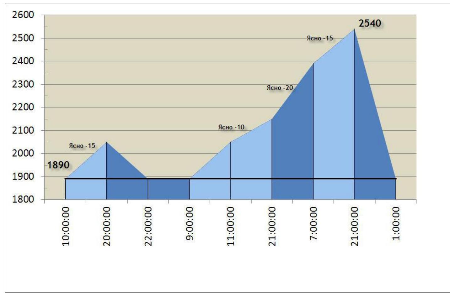
Processing start (10:00): April 12, 2014. Route start: 11:00, April 13, 2014. (Processed rappels completed, started working upwards). Summit reached: 21:00, April 14, 2014. Return to Base Camp: 02:00, April 15, 2014.
-
Report responsible: Klepikov A.A. (Baikalteam@Gmail.com).
General View Photo of the North Wall of Shtyk–Nozh Peak
Photo taken on April 16, 2014, from the summit of a lateral spur. The shooting height, according to the topographic map, is 2000 m above sea level.
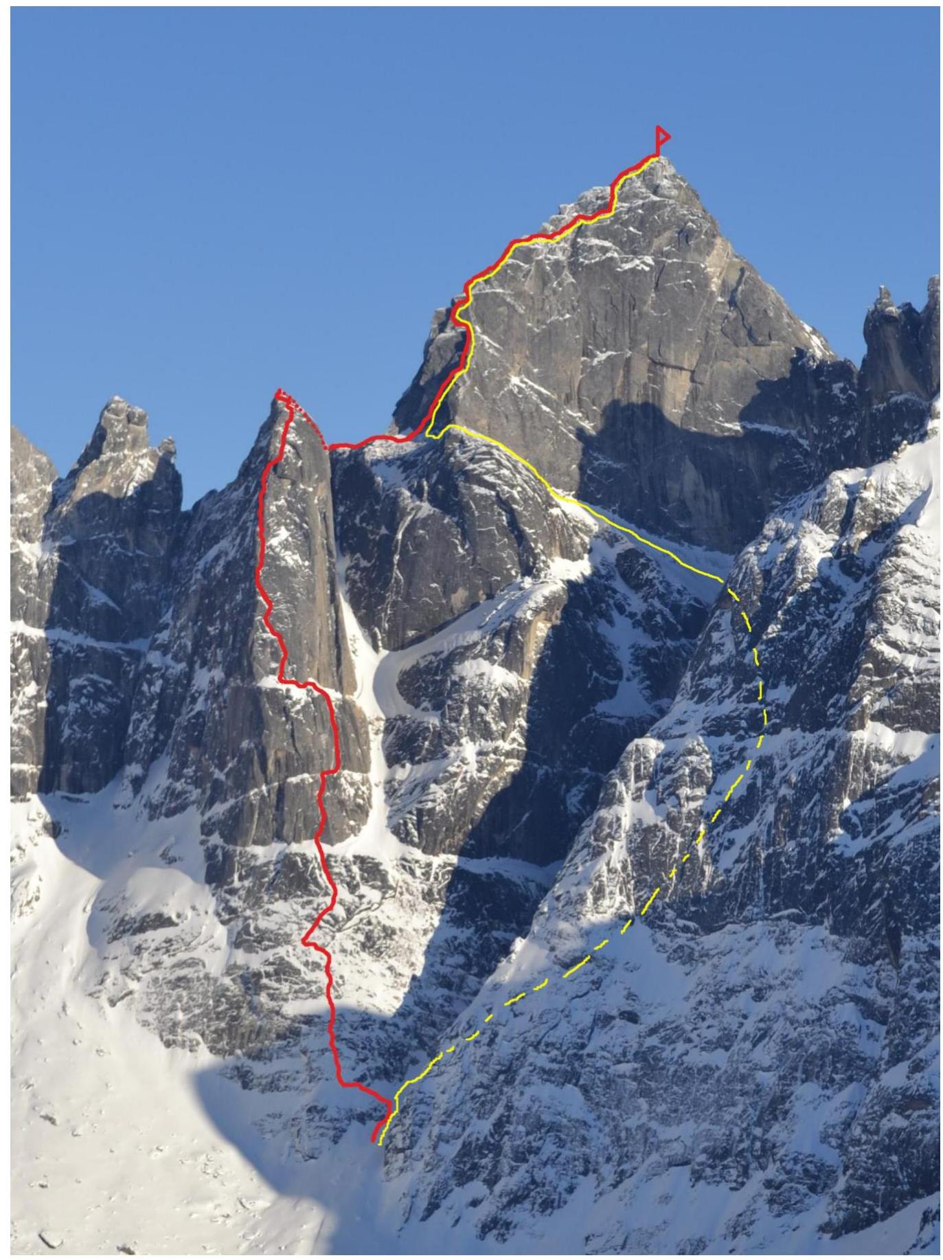
RED — Klepikov 2014 route, 6A cat. diff., new route. YELLOW — descent path.
List of Routes in the Area:
- RED — Klepikov 2014 route, 6A cat. diff., new route.
- YELLOW — descent path.
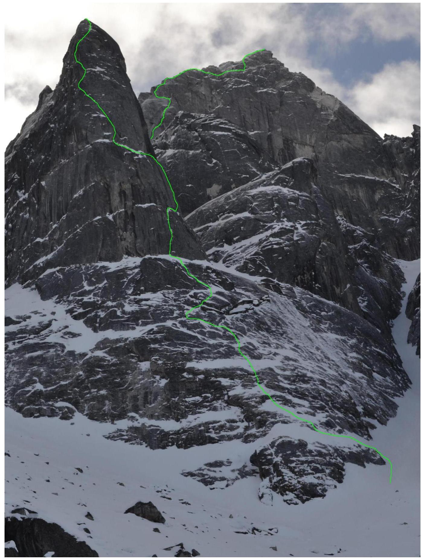
Route Profile Photo from the Right
Photo taken on April 13, 2014. Before completing the processed rappels the day before. Shooting height 1800 m.
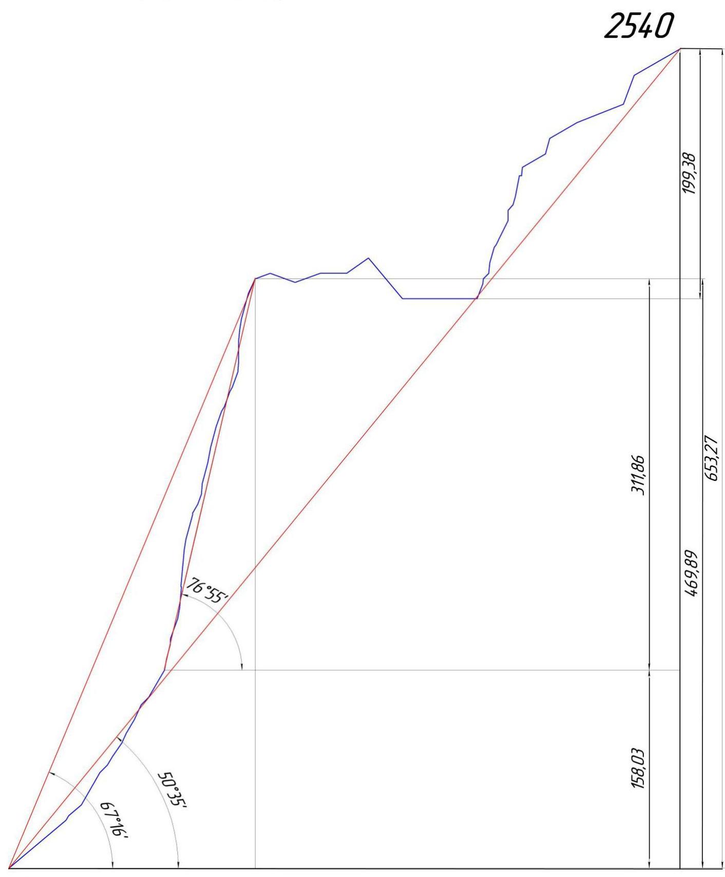
Drawn Route Profile
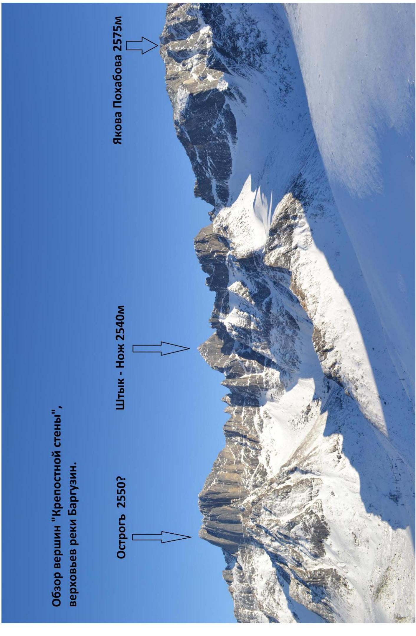
Panorama of the "Fortress Wall" peaks, Barguzin River upper reaches.
Map-Scheme of the Barguzin River Upper Reaches
The Barguzin River upper reaches — a new mountaineering area, which we visited first in 2011, but due to harsh weather conditions, we were only able to make a reconnaissance ascent — a first ascent on Yakov Pokhabov peak. And only this year we were able to return to the Ikatsky Ridge.
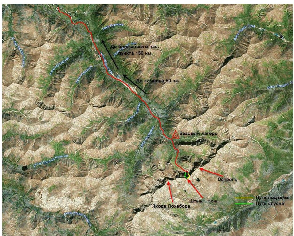
Geographical information: Shtyk–Nozh peak is located on the main, watershed crest of the Ikatsky Ridge, a few kilometers east of the highest point of the Ikatsky Ridge (Yakov Pokhabov mountain 2575 m above sea level), Kurumkan district, Republic of Buryatia. The nearest major settlement is Kurumkan village.
From Kurumkan, by a high-passability vehicle, you can reach the Barguzin River at the point where it intersects with the road, approximately 120 km from the village of Maisky or 90 km from the end of civilization. Then move along the ice of the Barguzin River:
- First transition — 25 km to the Balin-Tamur lake, where there is a habitable winter quarters.
- Second transition — 25 km to the end of the aufeis on the Barguzin River, where the river narrows significantly and looks like an ordinary mountain river.
- Third transition — 6–8 km to the base camp at the edge of the forest just below the cirques of Ostrog and Shtyk–Nozh.
The first time, it took us a week to deliver supplies due to abundant snow, the second delivery took only three days due to ideal conditions. In the summer, land delivery is practically impossible. Our route is the first technically difficult ascent in the area.
Ascent Schedule
Team's movement schedule on the route:
- April 12, 2014 — from 10:00 to 20:00: processed the first five ropes of the "Shtyk" tower, sections R0–R13.
- April 13, 2014 — from 09:00 to 11:00: completed the processed rappels on sections R0–R13, selected ropes.
- April 13, 2014 — from 11:00 to 21:00: completed sections R13–R22, passed the key section of the "Shtyk" tower, decided not to stop for a bivouac, continued climbing. (Forgot tea).
- April 13–14, 2014 — from 21:00 to 10:00: completed sections R22–R42, reached the summit of the bastion.
- April 14, 2014 — from 12:00 to 21:00: completed sections R48–R69, climbed seven ropes of the summit tower "Nozh" and reached the summit.
- April 14–15, 2014 — from 21:00 to 02:00: descended to the base camp, first seven ropes via the ascent route, then via the system of ledges on the north wall of Shtyk mountain.
The route has a northern exposure, so the sun only appeared before sunset for 2 hours, it was cold.
Route main section diagram, made in UIAA symbols, scale 1:2000. Sheet 1
| Section | Chocks | Friend | Rock Piton | Sky-hook/Fif | Bolt | Length (m) | Steepness (°) | Climbing | ITO |
|---|---|---|---|---|---|---|---|---|---|
| R45–R47 | - | 2 | 2 | - | - | 75 | 50 | 4- | - |
| R42–R45 | - | 3 | 2 | - | - | 75 | 30(70) | 4- | - |
| R41–R42 | - | - | - | - | - | 15 | 20 | 2+ | - |
| R40–R41 | - | 1 | - | - | - | 15 | 65 | 5- | - |
| R39–R40 | 1 | 5 | 2 | 5 | - | 25 | 75 | 5- | A3 |
| R38–R39 | - | - | 2 | 3 | - | 10 | 80 | 6+ | A3 |
| R37–R38 | 1 | 2 | - | 2 | 10 | 85 | 6- | A3 | |
| R36–R37 | - | 3 | 2 | 3 | 10 | 90 | 6- | A3 | |
| R35–R36 | - | - | 1 | 3 | - | 10 | 90 | 6+ | A4 |
| R34–R35 | - | 2 | 1 | 2 | 10 | 85 | 6- | A3 | |
| R33–R34 | - | 2 | 1 | - | - | 15 | 70 | 5- | A1 |
| R32–R33 | - | - | 3 | - | - | 5 | 60 | 4+ | - |
| R31–R32 | - | 2 | - | - | - | 15 | 70 | 5+ | |
| R30–R31 | - | 3 | 2 | - | - | 20 | 75 | 5+ | A1 |
| R29–R30 | - | 2 | 1 | 3 | 15 | 80 | 5+ | A2 | |
| R28–R29 | 1 | 3 | 4 | 5 | - | 20 | 75 | 5+ | A2 |
| R27–R28 | - | 1 | 4 | 4 | - | 10 | 85 | 6+ | A3 |
| R26–R27 | - | - | - | - | 10 | 70 | 5- | - | |
| R24–R25 | - | 2 | 3 | 5 | - | 24 | 75 | 5+ | A2 |
| R23–R24 | - | 3 | 2 | 5 | - | 10 | 80 | 5+ | A2 |
| R22–R23 | - | 2 | 1 | - | 35 | 50 | 3- | - | |
| R21–R22 | 2 | 3 | 1 | - | - | 35 | 50 | 3- | - |
| R20–R21 | 2 | 4 | 4 | 10 | - | 35 | 85 | 6+ | A3 |
| R19–R20 | - | 1 | - | - | - | 0.5 | 180 | 6+ | A2 |
| R18–R19 | 1 | 1 | 4 | 10 | - | 20 | 85 | 6- | A3 |
| R17–R18 | - | - | 2 | 3 | 10 | 80 | 5+ | A2 | |
| R16–R17 | 2 | 4 | 2 | 20 | 70 | 5+ | A1 | ||
| R15–R16 | - | 2 | - | 5 | 90 | 5+ | - | ||
| R14–R15 | - | 1 | 1 | - | - | 15 | 75 | 5- | A1 |
| R13–R14 | 1 | 1 | - | 10 | 80 | 5- | - | ||
| R12–R13 | 1 | 3 | 3 | 5 | - | 30 | 70 | 6- | A3 |
| R10–R11 | - | 1 | 1 | - | - | 15 | 70 | 5+ | - |
| R9–R10 | 1 | 2 | 1 | 2 | - | 15 | 65 | 4+ | - |
| R8–R9 | 1 | 2 | 1 | 5 | 25 | 70 | 5- | A1 | |
| R7–R8 | - | - | 4 | 3 | 10 | 70 | 5- | - | |
| R6–R7 | - | - | - | 2 | - | 15 | 60 | 4- | - |
| R5–R6 | - | - | 1 | 2 | - | 10 | 65 | 5- | - |
| R4–R5 | - | - | - | - | 10 | 50 | 3- | - | |
| R3–R4 | - | - | 5 | - | - | 35 | 65 | 5- | - |
| R2–R3 | - | - | - | - | 15 | 45 | 3- | - | |
| R0–R1 | - | - | 4 | - | - | 70 | 45 | 3+ | - |
Route main section diagram, made in UIAA symbols, scale 1:2000. Sheet 2
| Section | Chocks | Friend | Rock Piton | Sky-hook/Fif | Bolt | Length (m) | Steepness (°) | Climbing | ITO |
|---|---|---|---|---|---|---|---|---|---|
| R68–R69 | - | 1 | - | - | 1 | 50 | 40 | 4- | - |
| R67–R68 | - | 3 | 3 | 5 | - | 30 | 80 | 5+ | A2 |
| R66–R67 | - | 3 | 1 | - | - | 50 | 30 | 4- | - |
| R65–R66 | - | 2 | - | 30 | 30 | 4- | |||
| R64–R65 | - | 1 | 1 | - | - | 15 | 75 | 5+ | - |
| R63–R64 | - | 1 | 1 | 25 | 30 | 4- | |||
| R62–R63 | - | 3 | 2 | 4 | 1 | 8 | 90 | 6+ | A4 |
| R60–R61 | - | 1 | 4 | 5 | 20 | 85 | 6- | A2 | |
| R59–R60 | - | 1 | - | - | 1 | 8 | 80 | 5+ | A1 |
| R57–R59 | 1 | 2 | 1 | 14 | 55 | 4- | - | ||
| R56–R57 | - | - | 3 | 3 | - | 10 | 95 | 6+ | A3 |
| R55–R56 | - | 1 | 2 | 2 | 15 | 70 | 5- | - | |
| R54–R55 | - | 1 | 1 | - | - | 10 | 70 | 5- | - |
| R52–R53 | - | 3 | 3 | 2 | 1 | 15 | 80 | 5+ | A1 |
| R51–R52 | - | 3 | 1 | 5 | - | 10 | 90 | 6+ | A4 |
| R50–R51 | - | - | - | - | 7 | 50 | 2+ | - | |
| R49–R50 | - | 1 | - | 3 | - | 5 | 90 | 6+ | A2 |
| R48–R49 | - | 2 | 1 | 2 | 15 | 75 | 5+ | - | |
| R47–R48 | - | - | - | - | 70 | 0 | 1+ | - |
Belay points include points used for organizing stations. Scale of the UIAA diagram relative to the height difference.
Terrain Description
- 70 m, 55° R0–R1: 70 m, 45°, 3+. Snow and mossy rocks on a steep inclined ledge to the left.
- 55 m, 60°, 4+ R1–R2: 5 m, 65°, 4-. Wall. R2–R3: 15 m, 45°, 3-. Snow-covered slabs. R3–R4: 35 m, 65°, 5-. Ram's foreheads, problem with organizing a belay station.
- 45 m, 65°, 4+ R4–R5: 10 m, 50°, 3-. Snow-covered ledge, slabs. R5–R6: 10 m, 65°, 5-. Ram's foreheads, deep cracks. R6–R7: 15 m, 60°, 4-. Snow-covered slabs. R7–R8: 10 m, 70°, 5-. Wall.
- 40 m, 70°, 5-. Direction under the cornice to the left. R8–R9: 25 m, 70°, 5-, A1. Traverse along slabs to the left. R9–R10: 15 m, 65°, 4+. Up slightly to the right towards the cornice, main cornice is bypassed on the left, but a small one is collected.
- 55 m, 70°, 5+, exit to a large ledge. R10–R11: 15 m, 70°, 5+. From the station, a small cornice and up to a small ledge. R11–R12: 10 m, 50°, 3+. Snow to the right. R12–R13: 30 m, 65°, 6-, A3. Cracks filled with ice, ITO.
- 50 m, 75°, 5+ R13–R14: 10 m, 80°, 5-. Up to the corner — a chimney. R14–R15: 15 m, 75°, 5-, A1. Alive rock, undercut under the "Shkuroder". R15–R16: 5 m, 90°, 5+. "Shkuroder". R16–R17: 20 m, 70°, 5+, A1. Exit to a very small ledge.
- 65 m, 85°, 6+ R17–R18: 10 m, 80°, 5+, A2. Horizontal crack into the corner to the right. R18–R19: 20 m, 85°, 6-, A3. VU, cracks filled with ice. R19–R20: 0.5 m, 180°, 6+, A2. Cornice with live rock. R20–R21: 35 m, 85°, 6+, A3. Crack upwards, filled with ice and earth, 60 m rope is only enough to reach the beginning of a large ledge.
- Hor, 35 m, 50°, 3- R21–R22: 35 m, 50°, 3-. Ledge to the left around the corner to an oblique VU with a couple of cornices.
- 45 m, 75°, 5+ R22–R23: 10 m, 80°, 5+, A2. Randomly upwards, override the rib to the right into an internal corner. R23–R24: 24 m, 75°, 5+, A2. Along VU under a small overhang. R24–R25: 1 m, 100°, 6-, A2. Cornice, overhang. R25–R26: 10 m, 60°, 4-. Snow-covered ledge with a wall, station to the left.
- 40 m, 80°, 5+ R26–R27: 10 m, 70°, 5-. From the station to the left along an inclined crack with grass. R27–R28: 10 m, 85°, 6+, A3. Move to the right into a chimney under a cornice on relief sky-hooks. R28–R29: 20 m, 75°, 5+, A2. Steep chimney filled with ice and snow. Exit to the left rib of the bastion.
- 55 m, 75°, 5+ R29–R30: 15 m, 80°, 5+, A2. Slightly left upwards, VU, exit to the "cucumber" to the right. R30–R31: 20 m, 75°, 5+, A1. Upwards, climbing on frozen live rocks and cracks. R31–R32: 15 m, 70°, 5+. Chimney with stacked stones "Alive". R32–R33: 5 m, 60°, 4+. Along a system of snow-covered ledges.
- 45 m, 85°, 6+ R33–R34: 15 m, 70°, 5-, A1. To the left along a system of ledges into VU. R34–R35: 10 m, 85°, 6-, A3. ITO along VU, everything crumbles, very bad belay. R35–R36: 10 m, 90°, 6+, A4. Traverse to the right into a crack, not worth going up, ITO along a crumbling wall, one hole for a sky-hook, in case of a fall — a pendulum against the VU wall, no points!!! R36–R37: 10 m, 90°, 6-, A3. ITO along a bad crack with crumbling edges.
- 45 m, 75°, 6- R37–R38: 10 m, 85°, 6-, A3. ITO along VU upwards. R38–R39: 10 m, 80°, 6+, A3. Move to the right ITO to relief hooks. R39–R40: 25 m, 75°, 5-, A3. VU, cracks filled with ice, the corner is filled with snow, relief for climbing has to be dug out, snow is stuck to rocks with a steepness of even 90° degrees.
- 30 m, 4- R40–R41: 15 m, 65°, 5-. Exit from the bastion wall to its summit. R41–R42: 15 m, 20°, 2+. From the edge of the wall to a stone on the bastion summit, station on it.
- 50 m, 3+ R42–R43: 25 m, 30°, 4-. Sharp ridge from the bastion summit towards the main peak and watershed ridge. R43–R44: 25 m, 30°, 3+. Bypassing a gendarme to the right along snow-covered ledges.
- 50 m, 45°, 4- R44–R45: 25 m, 0°, 4+. Through an overhang along a narrow ledge above a vertical rock. R45–R46: 25 m, 50°, 4-. To the left onto a saddle between gendarmes and along the ridge to the second gendarme.
- 50 m, 50°, 4- R46–R47: 50 m, 50°, 4-. Descent from the gendarme towards the main peak, at the end a 8-meter rappel.
- 70 m, 0°, 1+ R47–R48: 70 m, 0°, 1+. Horizontal traverse to the right, shaded side of the ridge under a system of VU.
- 55 m, 75°, 6- R48–R49: 15 m, 75°, 5+. System of cracks upwards. R49–R50: 5 m, 90°, 6+, A2. Small cornice. R50–R51: 7 m, 50°, 2+. Ledge. R51–R52: 10 m, 90°, 6+, A4. Destroyed cornice 1 m, with live wedged blocks, blocks move, in case of a fall, a 7–8 meter fall onto a ledge. R52–R53: 15 m, 80°, 5+, A1. VU, filled with ice. R53–R54: 3 m, 60°, 4-. Approach to the station on a bend.
- 50 m, 75°, 6- R54–R55: 10 m, 70°, 5-. From the station to the left into the corner. R55–R56: 15 m, 70°, 5-. VU, ice. R56–R57: 10 m, 95°, 6+, A3. Cornice, hanging VU upwards. R57–R58: 7 m, 55°, 4-. Move to the wall. R58–R59: 7 m, 50°, 3-. To the left under the wall along a ledge.
- 38 m, 85°, 6- R59–R60: 8 m, 80°, 5+, A1. Wide crack. R60–R61: 20 m, 85°, 6-, A2. VU, cracks. R61–R62: 2 m, 0°, 2-. Ledge. R62–R63: 8 m, 90°, 6+, A4. ITO on relief sky-hooks, in case of a fall, a fall onto a ledge.
- 40 m, 50°, 5- R63–R64: 25 m, 30°, 4-. Sharp snow ridge, abysses on both sides, no belay. R64–R65: 15 m, 75°, 5+. Gendarme on the ridge, quite difficult climbing.
- 80 m, 30°, 4- R65–R66: 30 m, 30°, 4-. Sharp snow ridge. R66–R67: 50 m, 60°, 30°, 4-. Along a faintly expressed ledge to the right of the ridge to its end, then upwards.
- 30 m, 80°, 5+ R67–R68: 30 m, 80°, 5+. From the ledge, exit to the ridge before the summit.
- 50 m, 40°, 4- R68–R69: 50 m, 40°, 4-. Steep rocky-snowy ridge, then to the left of the ridge in a screw motion to the summit.
Technical Photo of the Route
Photo taken on April 16, 2014, from the eastern slope of the lateral, northern spur of the main ridge. Shooting height 1800 m.

Route Characteristics and Team Actions on the Wall
The route climbed by our team is the first ascent to Shtyk–Nozh peak. The route follows the north wall and the east ridge of the mountain. There are no easy paths to the summit!
The descent from the summit was made via the ascent route until section R48 (seven ropes), with four bolted descent stations (8 mm × 56 mm Hilty pins), then via a system of couloirs on the north wall to the right of the route thread, approximate category of difficulty of the descent route when ascending it is 5A — this is the simplest way to ascend the peak. Since there were no routes on the peak before, we chose:
- the most beautiful and logical line, fully tied to the terrain;
- tried to adhere to the external forms of the terrain as much as possible to minimize the danger of rockfall.
Since the route was climbed in cold weather, a significant part of the route was completed using ITO. To increase the number of sections climbed using free climbing, we brought lightweight climbing boots. The difficulty of sections climbed on dry rocks is 6A (French scale), more difficult sections were climbed using ITO. Also, part of the route prone to icing was climbed using:
- fiffies;
- crampons.
The route length is 25 pitches, from 30 to 80 m, of which 17 are technically difficult — from 30 to 65 m, averaging 45 m.
Comparison of the route with other 6th category routes climbed earlier. Our route is more difficult than such classified 6A routes as:
- Ergaki, Zvezdny peak, 6A, Central NW route by Khvostenko;
- Eastern Sayan, Kupon peak, 6A, Central S route by Kuzmenko, 2010.
The route is monolithic, the rocks are of an intrusive type, mainly granite and syenite, relatively rock-dangerous is only the upper part of the "Shtyk" bastion in the summer. Almost all stations were organized in rockfall-protected areas.
Initially, it was planned to climb the route non-stop, but it turned out that the scale of the mountain was significantly larger than expected, and the difficulty of the sections was higher. It was decided to process the route considering the available rope length. On the second day, a significant amount of time was spent overcoming the key ropes. Before nightfall, a suitable ledge for a bivouac was not found, so it was decided to continue climbing non-stop. In hindsight, this decision was correct, as the summit was only reached by sunset the next day.
Ilyinsky V.A. led during the processing, Klepikov A.A. led on the rest of the route:
- Ilyinsky V.A. worked on two dynamic ropes meeting UIAA requirements;
- Klepikov A.A. moved along the perils with belay.
To speed up the work, friends and anchor pitons were mainly used. The technical photo indicates the time it took for both participants to pass a point.
Comments
Sign in to leave a comment