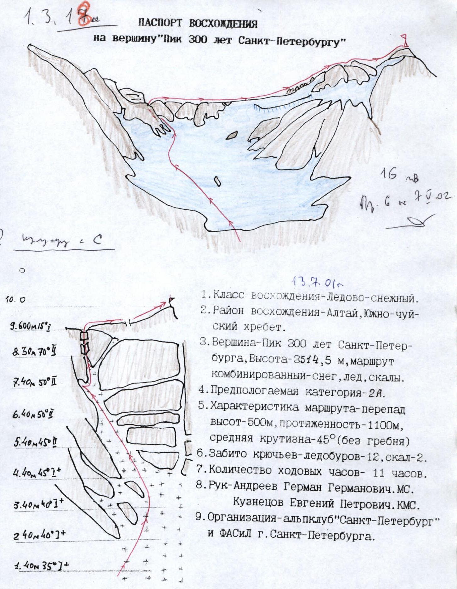
July 13, 2001
ASCENT DOCUMENT for the summit "Peak 300 years of St. Petersburg"
- Ascent category – Ice and snow.
- Ascent area – Altai, South Chuya Ridge.
- Peak – Peak 300 years of St. Petersburg, Height – 3514.5 m, combined route – snow, ice, rocks.
- Expected category – 2A.
- Route characteristics: height difference – 500 m, length – 1100 m, average steepness – 45° (excluding the ridge).
- Number of ice screws used – 12, rock anchors – 2.
- Total climbing hours – 11 hours.
- Leaders – German G. Andreev, Master of Sports. Evgeny P. Kuznetsov, Candidate Master of Sports.
- Organisation – Alpine club "St. Petersburg" and FASIL St. Petersburg.
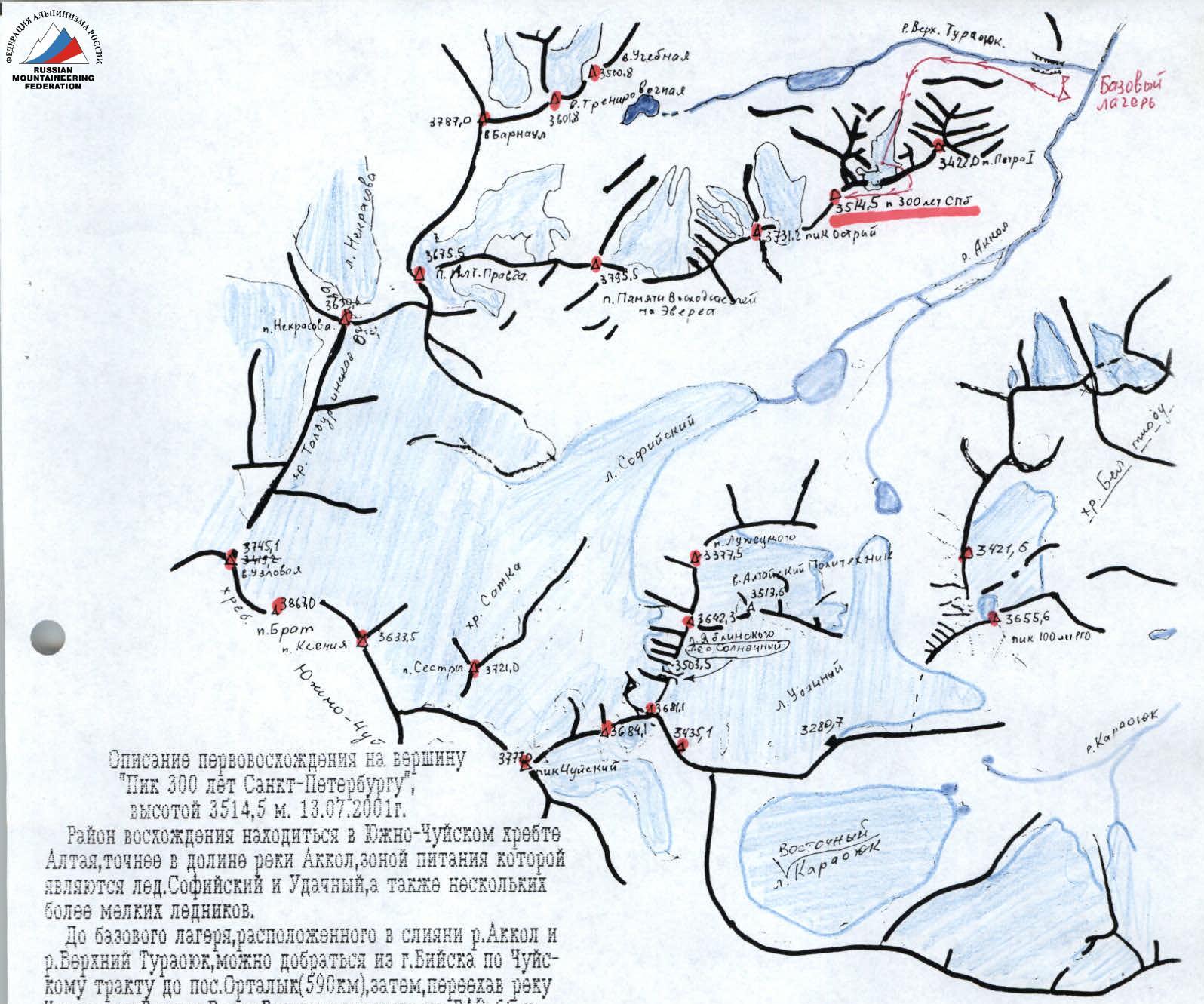
Description of the first ascent to the summit "Peak 300 years of St. Petersburg"
Height 3514.5 m. July 13, 2001
The ascent area is located in the South Chuya Ridge of Altai, more precisely in the Akkol river valley, which is fed by the Sofiyskiy and Udachny glaciers, as well as several smaller glaciers.
To reach the base camp, located at the confluence of the Akkol and Verkhny Turasyuk rivers, one can travel from the city of Biysk along the Chuyskiy tract to the village of Ortalyk (590 km), then, crossing the Chuya river, to the village of Beltir. In Beltir, switch to a GAZ-66 vehicle and follow the left orographic bank of the Chegan-Akkol river to the Akkol river, and then to the Verkhny Turasyuk river.
From the camp, move towards the start of the route along the Verkhny Turasyuk river, keeping close to the right orographic slope of the Hanging valley. After 30 minutes, a large-boulder talus begins, leading to the first cirque of the South Chuya Ridge spur, where the following peaks are located:
- Peak Ostry (3731.2 m)
- Peak Pamyati voskhoditeley na Everest (3614.0 m)
The cirque contains a cirque glacier. The journey from the camp takes 1 hour 30 minutes. To the south, the cirque is bounded by a steep rocky wall, which transitions into an ice fall with an overhanging cornice in its western part.
The route begins in the eastern part of the glacier, where a couloir is clearly visible. Initially, the slope of the glacier is 20°, then the steepness increases, and ice appears 3 rope lengths before the mouth of the couloir.
Equipment:
- Crampons
- Ice screws – start of the route
Characteristics:
- Slope steepness – 35–40°
- Couloir is steep, icy, with steep sides: the right side is monolithic, the left side is heavily fractured.
Passage:
- Up to the last rope length – traverse through the center of the couloir (sections R4–R7 with protection via ice screws).
- Before reaching the rocks (internal corner leading to the ridge) – protection in a rocky chimney to avoid dislodging rocks onto the belayers.
- Exit onto the ridge – via a very steep, rock-filled internal corner, and then along a small wall.
- Along the ridge – move to the right, onto not too steep (~15°) ice and snow shelves, and traverse around seracs – 600–700 m.
- Cairn – on the highest of them.
Time:
- Time from the start of the glacier traverse – 6 hours.
- Descent via the ascent route – 5 hours.
Equipment for descent:
- 6 ice screw stations with 2 screws each were set up.
- 1 rock anchor station with 2 anchors and a nut.

View of the South Chuya Ridge spur, separating the Akkol and Verkhny Turasyuk river valleys. Photographed from Peak 100 years of RGO. Photo by Valakhnichev A.V.