
Report
on the first ascent of the route to the summit DVS, 3755 m, Altai Republic, Kosh-Agachsky district, North-Chuya ridge, Akturu gorge
via the icy slope through Jelo pass 3A cat. diff. (combined) by a group of climbers at the Tomsk Alpinism Federation gathering on November 2, 2022.
Participants:
Temerev Ivan Mikhailovich, Master of Sports
Khasanov Nail Albertovich, 3rd sports category
Shubin Andrey Sergeevich, 3rd sports category
Bunkov Viktor Evgenievich, 3rd sports category
Saraev German Igorevich, 3rd sports category
Tarasova Olga Sergeevna, 3rd sports category
Yatsenko Oksana Andreevna, 3rd sports category
I. Ascent Passport
| № | 1. General Information | |
|---|---|---|
| 1.1 | Full name, sports rank of the leader | Temerev Ivan Mikhailovich, Master of Sports |
| 1.2 | Full name, sports rank of participants | Khasanov Nail Albertovich, 3rd sports category; Shubin Andrey Sergeevich, 3rd sports category; Bunkov Viktor Evgenievich, 3rd sports category; Saraev German Igorevich, 3rd sports category; Tarasova Olga Sergeevna, 3rd sports category; Yatsenko Oksana Andreevna, 3rd sports category |
| 1.3 | Full name of the coach | Temerev Ivan Mikhailovich, Master of Sports |
| 1.4 | Organization | Tomsk Alpinism Federation |
| 2. Characteristics of the Ascent Object | ||
| 2.1 | Region | Akturu gorge |
| 2.2 | Ridge | North-Chuya ridge |
| 2.3 | Classification table section number for 2020 | ALTAI |
| 2.4 | Name and height of the summit | DVS, 3755 m |
| 2.5 | Geographical coordinates of the summit (latitude/longitude), GPS coordinates | N 50°03′12.48″ E 87°41′58.27″ |
| 3. Characteristics of the Route | ||
| 3.1 | Route name | Summit DVS via the icy slope through Jelo pass |
| 3.2 | Proposed category of difficulty | 3A |
| 3.3 | Degree of route exploration | Presumably a first ascent, possibly first ascended in 1957 (see Afanasiev's report, 1993: DVS — Krylia Sovetov) |
| 3.4 | Route terrain | Combined |
| 3.5 | Route elevation gain (according to GPS data) | 555 m |
| 3.6 | Route length (in meters) | 690 m, not including the approach |
| 3.7 | Technical elements of the route (total length of sections with different difficulty categories, specifying the terrain type) | II cat. diff. — 300 m: ice, 35–50° slope, 150 m, including a rocky ridge with up to 40° slope, partially iced — 150 m; III cat. diff. — 390 m: ice, 45–60° slope, 240 m, including a rocky ridge with up to 90° slope — 150 m. Glacier travel — 1 km. Rappelling (on descent) — 4 ropes, 240 m. |
| 3.8 | Descent from the summit | Via the ascent route. 3A cat. diff. at 17:30 in the Akturu gorge. |
| 3.9 | Additional route characteristics | Water is likely present during warm seasons. In cold seasons, be cautious of avalanche danger on the Jelo pass slope and the upper part of DVS's Eastern ridge. |
| 3.10 | Equipment used | Ice tools — 7 pairs; ropes — 4×70 m (1/2), 1×60 m; ice screws — 3 pcs.; local loops with carabiners — 6 pcs.; short quickdraws with carabiners — 30 pcs. |
| 4. Characteristics of the Team's Actions | ||
| 4.1 | Time taken (team's climbing hours) | 19 hours, including approach — 8 hours, ascent — 5 hours, descent and return — 7 hours. |
| 4.2 | Overnight stays | — |
| 4.3 | Start of the route | 4:00, November 2, 2022 — departure from Akturu alpine camp; 12:00 — start of work on the route. |
| 4.4 | Summit attainment | 17:00; 17:30 — start of descent. |
| 4.5 | Return to base camp | 23:00 |
| 5. Report Responsible | ||
| 5.1 | Full name, e-mail | Temerev I.M., ivantem@ngs.ru |
II. Ascent Description
1. Characteristics of the Ascent Object
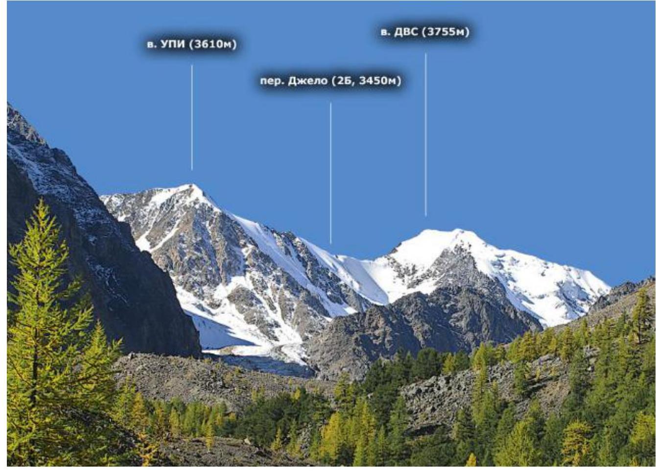
1.1. General photo of the summit DVS, 3755 m using, shown on photos 1, 2, 3, 4.
Photo 1 taken from the slopes of Kupol peak at an approximate height of 3000 m.

Photo 2 taken from Pravy Akturu glacier at an approximate height of 3000 m.
 Photo 3. Photo by Yu. Surikov, 2011. Taken from https://pereval.online↗. Shot from Akturu valley between the slopes of Karatash and Kzyltal peaks.
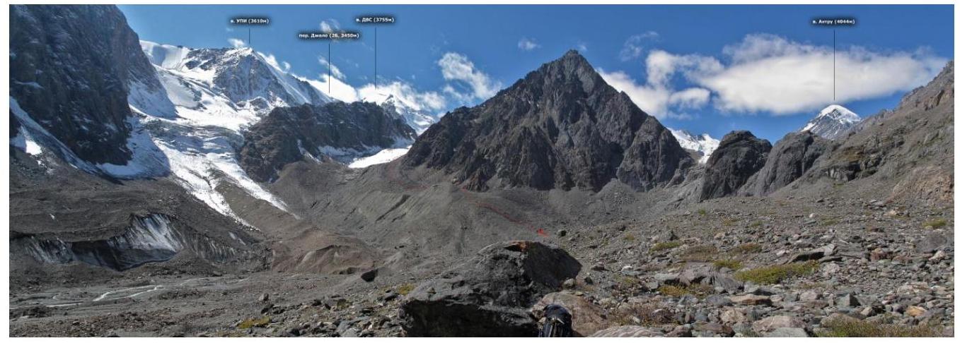
Photo 4. Photo by Yu. Surikov, 2011. Taken from https://pereval.online↗. Shot from Akturu gorge at the confluence of Akturu and Maly Akturu rivers.
1.2. Profile photo of the route
Figure 1. Screenshot of the profile of the Eastern ridge on DVS summit. Screenshot taken from https://www.google.ru/maps↗.
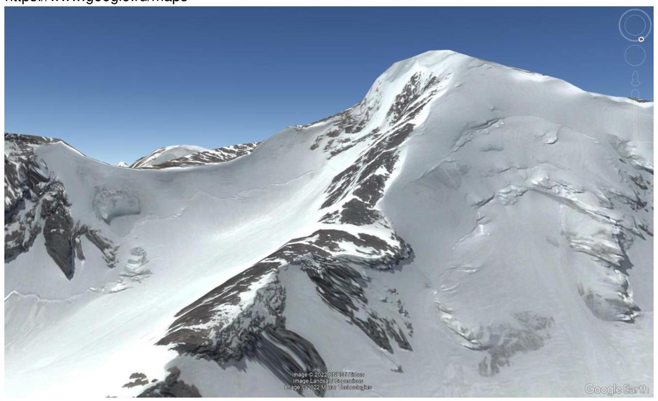
Photo 1 of the profile of the lower part of the route via the icy slope to Jelo pass. Taken from Pravy Akturu glacier at an approximate height of 3000 m.
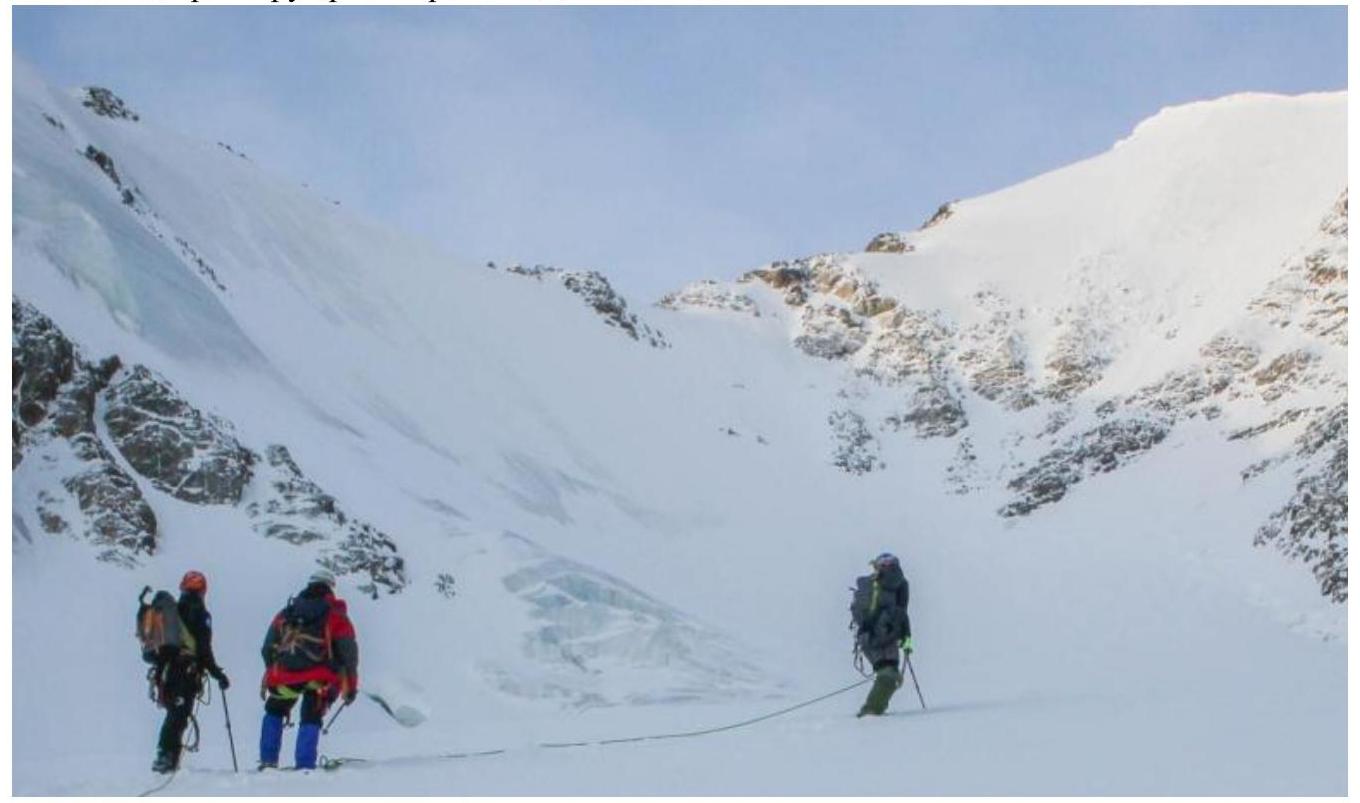
Photo 2 of the profile of the lower part of the route via the icy slope to Jelo pass.
1.3. Panoramic photo of the area
1.4. Area map
Taken from open internet sources.
Taken from open internet sources.
1.5. Geographical location of the area, its features, remoteness with indication of distance and time of approach or drive from the nearest settlement to the base camp (BC) and from BC to the start of the route. Description of the approach is provided according to the scheme: city (village), gorge, glacier, pass, summit.
Summit DVS («Dalnevostochnykh Stroitelei»), 3755 m above sea level, is located between UPI and Burevestnik peaks. GPS: 50.05308, 87.69923 — south of Akturu peak and SW of Akturu alpine camp. In good weather, it is clearly visible from the Akturu river in the alpine camp. Located in the Altai Republic, Kosh-Agachsky district, North-Chuya ridge, Akturu gorge.
The Akturu alpine camp can be reached from Kurai village (826 km along the Chuya tract) by a high-clearance vehicle — 32 km. By van, it usually takes about 2 hours.
The distance from Akturu alpine camp to DVS summit is about 11 km. The following is a description of the winter approach to the route.
Follow the trail to Baranii Lby. From there, descend to the Akturu river and ascend to the moraine ramparts under the eastern slopes of Radiist peak. It's not worth turning left too much, let alone climbing the separate moraine hillock Tronova. Even in a low-snow period, the gorge can be unpleasantly deep here.
Move towards Khitsan (under the nunatak dividing the Pravy Bolshoi Akturu glacier) and walk along the glacier along Khitsan to its western extremity, where it abuts the main glacier. Here is a large depression, possibly sheltered from the wind, where a tent can be set up for a storm camp.
The first time, following colleagues' tracks, we covered this segment with gear in 4.5 hours. The second time without gear — in 3 hours 20 minutes. Colleagues with a bivouac and ascent gear walked for 6 hours in bad weather.
Having reached the glacier on the southern side of Khitsan and overcome ice crevasses in rope teams, move along the glacier between the western ridge of UPI and the northeastern ridge of DVS towards the start of the ascent to Jelo pass.
In our case, it was more convenient to pass the crevasses further left — closer to the slopes of UPI peak.
From Khitsan to the pass, it took about 3 hours. Currently, there are three routes to the summit.
| № | Region | Area | Summit | Route | h, m | Difficulty | Character | Leader | Description | |
|---|---|---|---|---|---|---|---|---|---|---|
| 22 | ALTAI | North-Chuya ridge | DVS | via S couloir of NE ridge | 3755 | 3A | ice/snow | Afanasiev Andrey Evgenievich | – | + |
| 22a | ALTAI | North-Chuya ridge | DVS | via NE ridge | 3755 | 3B | k | Bazhenov N. | Description | + |
| 22b | ALTAI | North-Chuya ridge | DVS | via S couloir of NE ridge, traverse | 3B | ice/snow | Afanasiev Andrey Evgenievich | Description | + |
2. Characteristics of the Route
2.1. Technical photo of the route
Photo #1. Taken from Pravy Akturu glacier at an approximate height of 3000 m.
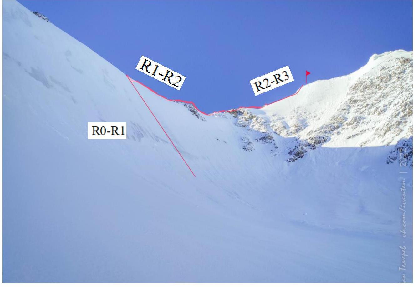
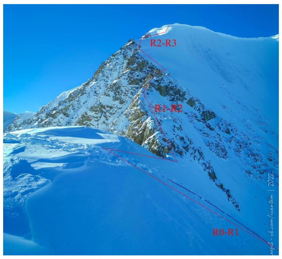
Photo #2. Taken from NE ridge of DVS summit at an approximate height of 3200 m.
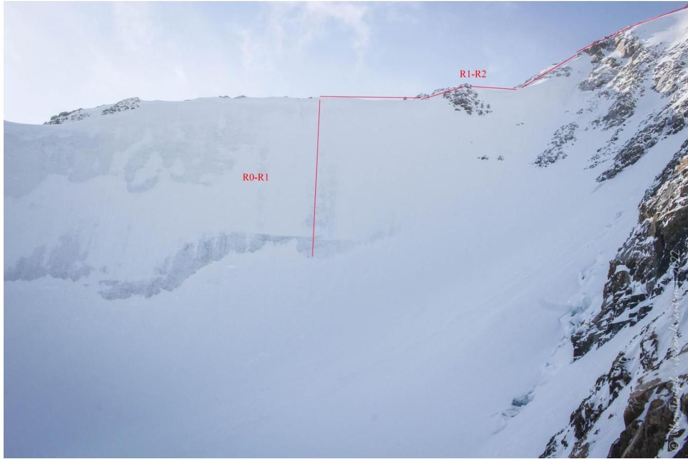
Photo #3. Taken from NE ridge of DVS summit at an approximate height of 3500 m.

Photo #4. Taken from Eastern ridge of DVS summit at an approximate height of 3500 m.
2.2. Route diagram in UIAA symbols
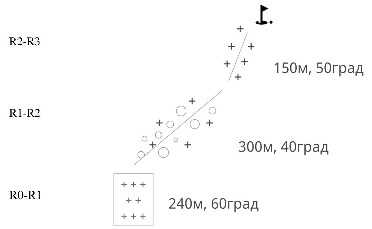
2.3. Technical characteristics of route sections
| Section number | Terrain type | cat. diff. | length | type and number of screws |
|---|---|---|---|---|
| R0–R1 | Ice covered with a thin layer of snow, 45–60° slope | III | 240 | Porous ice, difficult to make stations — need to chop 10–20 cm, ice screw belay every 7–10 m. |
| R1–R2 | Rocky ridge, simple rocks; 30–40° slope, местами стенки up to 90° | II–III | 300 | Simultaneous movement. On walls — alternating movement. |
| R2–R3 | Snow-ice slope, 50° | II | 150 | Movement in rope teams. |
3. Characteristics of the Team's Actions
3.1. Brief description of the route passage.
Accompanied by photo illustrations (at least 4). The distance from Akturu alpine camp to the summit is about 11 km. We draw your attention to the fact that the ascent was made in early November.
Route:
- Follow the trail to Baranii Lby.
- From there, descend to the Akturu river and ascend to the moraine ramparts under the eastern slopes of Radiist peak.
- It's not worth turning left too much, let alone climbing the separate moraine hillock Tronova.
- Move towards Khitsan (under the nunatak dividing the Pravy Bolshoi Akturu glacier).
- Walk along the glacier along Khitsan to its western extremity, where it abuts the main glacier.
- Here is a large depression, possibly sheltered from the wind, where a tent can be set up for a storm camp.
Time taken for the section:
- The first time, following colleagues' tracks, we covered this segment with gear in 4.5 hours.
- The second time without gear — in 3 hours 20 minutes.
- Colleagues with a bivouac and ascent gear walked for 6 hours in bad weather.
Even in a low-snow period, the gorge can be unpleasantly deep here.
Having reached the glacier on the southern side of Khitsan and overcome ice crevasses in rope teams, move along the glacier between the western ridge of UPI and the northeastern ridge of DVS towards the start of the ascent to Jelo pass.
In our case, it was more convenient to pass the crevasses further left — closer to the slopes of UPI peak.
From Khitsan to the pass, it took about 3 hours.
| Section № | Description | Photo number |
|---|---|---|
| R0–R1 | Key section. Ice covered with a thin layer of snow, 45–60° slope. Movement in rope teams and crampons, using ice tools, ice screw belay. The slope is wide, moved in independent rope teams in parallel. Be attentive and choose a place with the cleanest ice — high avalanche danger! At the start of the slope, a large bergschrund — be extremely cautious! | Photo #3–6 |
| R1–R2 | Rocky ridge, simple rocks; 30–40° slope, местами стенки up to 90°. Rocks are partially iced. Movement in rope teams — simultaneous. On walls — alternating. | Photo #7–11 |
| R2–R3 | Snow-ice slope ending in a cornice; up to 50° slope. Movement in rope teams and crampons — simultaneous. Under the cornice, the leader moved right and chopped so that falling parts flew past the group. | Photo #12–13 |
Photo #1. Approach to the bergschrund at the start of section R0–R1.
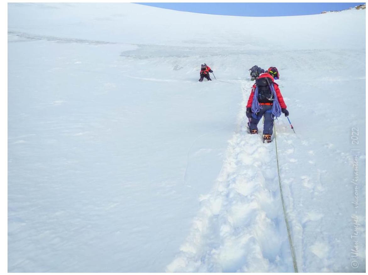
Photo #2. Start on section R0–R1 from the bergschrund.
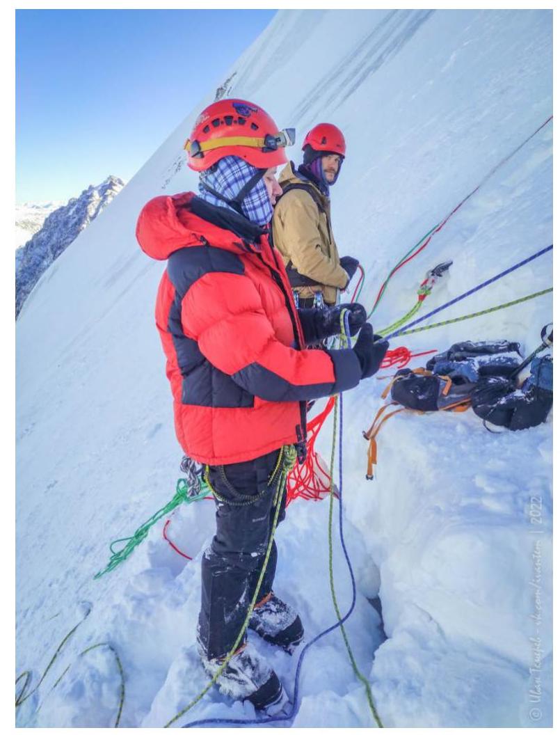
Photo #3. R0–R1. First rope.
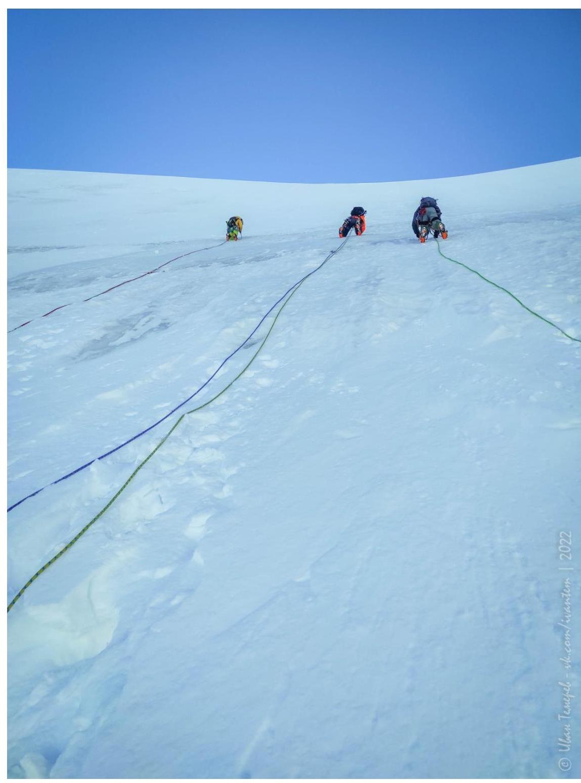
Photo #4. R0–R1. Second rope.
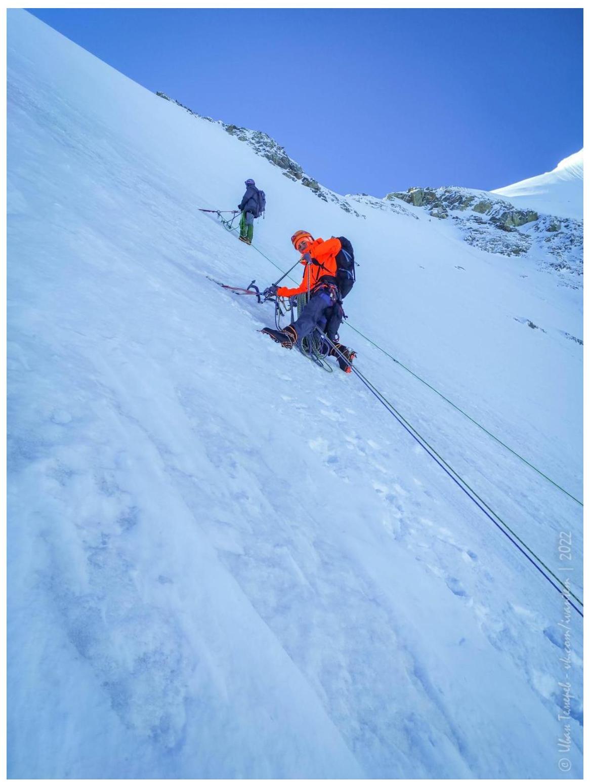
Photo #5. R0–R1. Third rope.
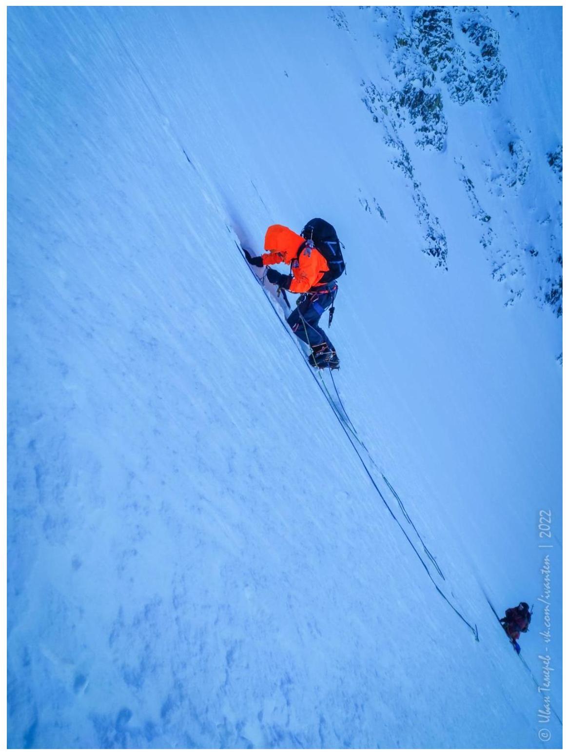
Photo #6. R0–R1. Exit at the end of the 4th rope to the Eastern ridge of DVS summit. Note that the slope below is not visible due to the bend (!).
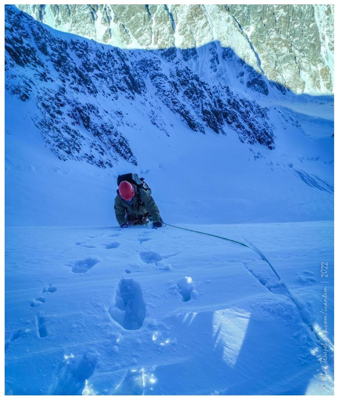
Photo #7. Shows the end of R0–R1 and the Eastern ridge of DVS — R1–R3.

Photo #8. R1–R2. Work on the Eastern ridge.
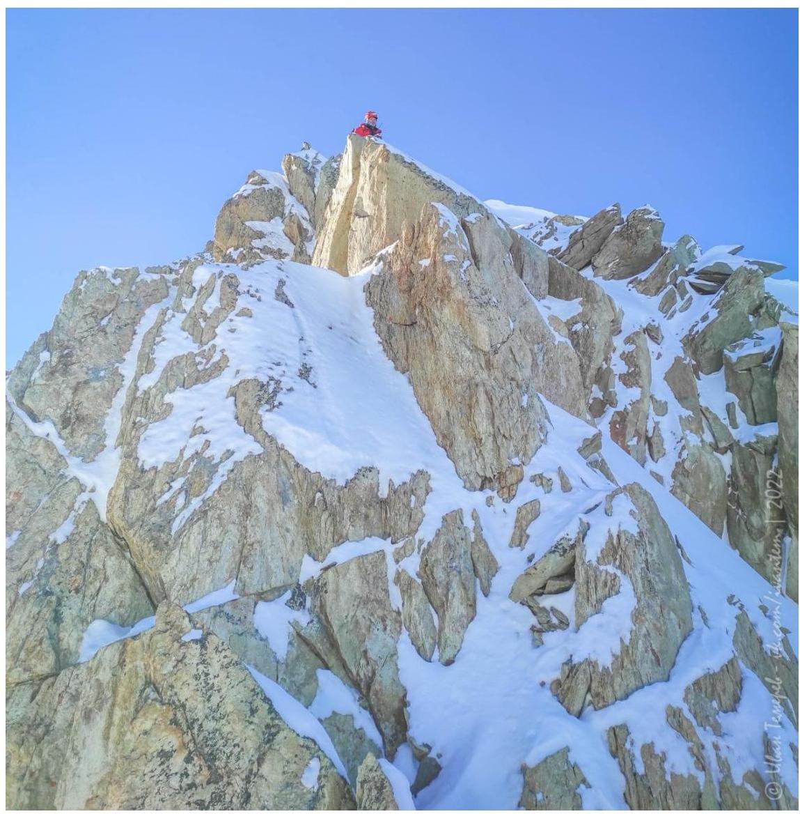
Photo #9. R1–R2. Rocky walls on the Eastern ridge.
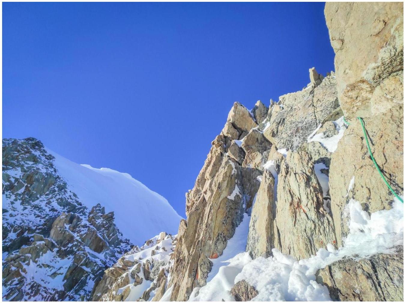
Photo #10. R1–R2. On the Eastern ridge.

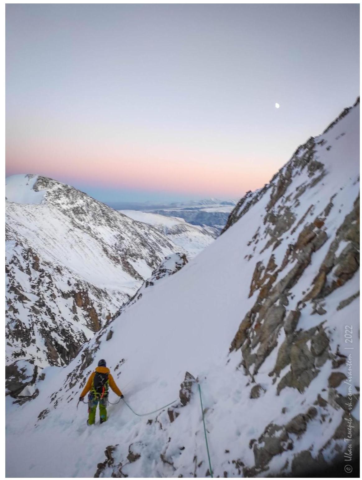
Photo #11. R1–R2. On the Eastern ridge. Taken on descent.
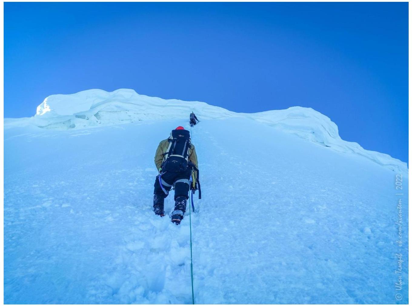
Photo #12. R2–R3. On the Eastern ridge.
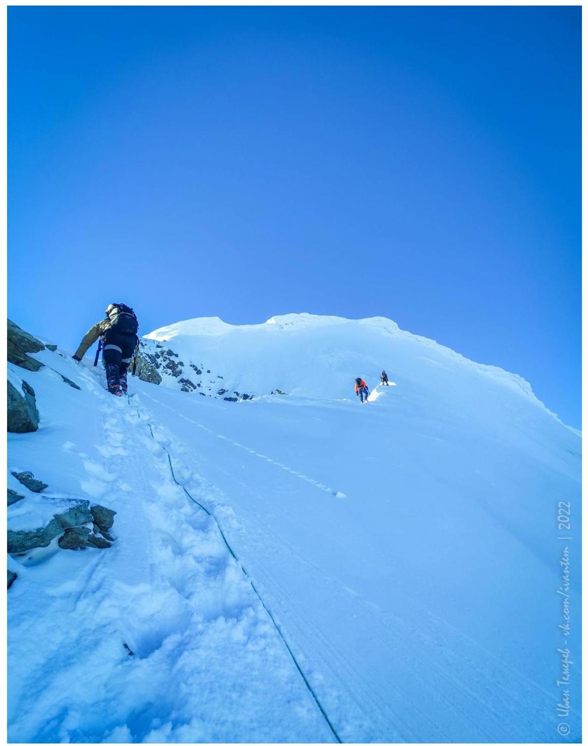
Photo #13. R2–R3. On the Eastern ridge. Exit through the cornice to the summit.
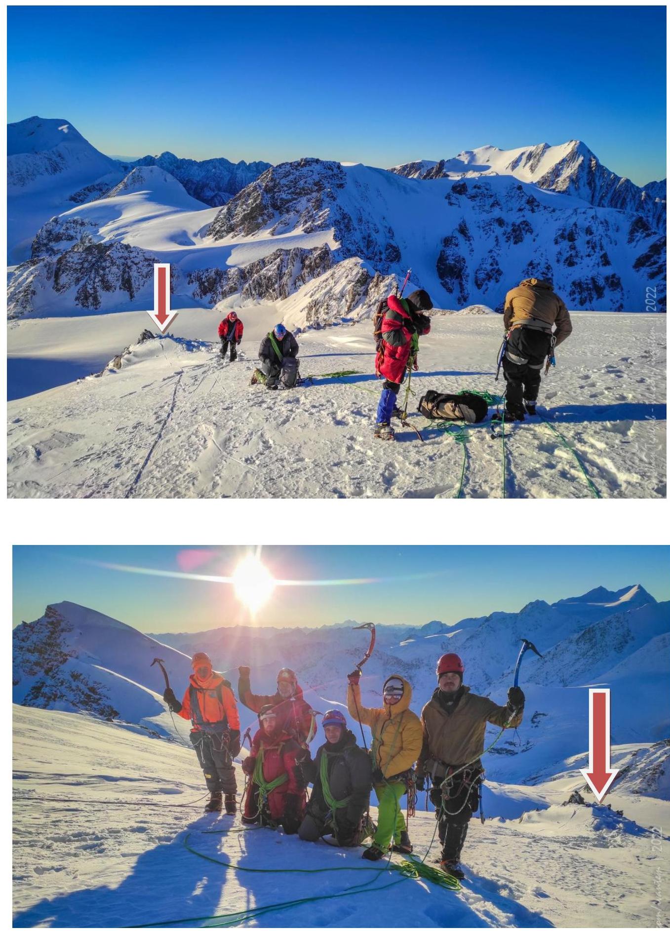
3.2. Photo of the team on the summit with the control landmark.
Control landmark not found. Made one ourselves.
3.3.1. Route safety assessment.
The route seemed fairly safe to us, but when ascending the Eastern ridge, one needs to be cautious of avalanche danger and choose a safe part of the icy slope, as it is very wide and allows for finding a clean section. When exiting to the summit, the leader needs to move left or right — depending on the situation — to avoid undermining the cornice on the group.
3.3.2. Communication options on the route.
Used Baofeng radios with RHD-771 antennas for communication with Akturu alpine camp. Without the antennas, communication in BC was intermittent. When both radios were equipped with extended antennas, communication became stable. Conducted communication sessions every 3 hours, starting at 9:00.
No cellular communication on the ridge or summit.
3.3.3. Recommendations for subsequent climbers.
Comfortable for a start to spend the night in the depression near Khitsan.
3.3.4. Detailed information about the descent from the summit, indicating landmarks.
There are three descent options:
- Via the ascent route. Convenient because Abalakov anchors can be made during the ascent. 4 rappel sections.
- To the west towards Burevestnik summit and further from Fiskulturnik pass. Inconvenient in winter due to unknown pass conditions and subsequent need to trailblaze on Pravy Akturu glacier and untangle crevasses around Khitsan.
- Via NE ridge and further — to the middle couloir to the south. Inconvenient in winter due to unknown snow conditions on the ridge. However, after completing 3B on DVS, we did just that. One 30 m rappel in the couloir to the south. Potentially avalanche-prone!
3.3.5. Conclusion on the preliminary route assessment compared to classified routes of the same category of difficulty in the team's climbing experience.
Average for the area 3A. Interesting due to the presence of combined terrain.
More complex and engaging:
- Kzyltash via the North slope of SW ridge 3A
- DVS via NE ridge 3B
Easier in the icy part than:
- Kzyltash via the icefall on NW slope 3B
But more labor-intensive due to:
- Remoteness from alpine camp
- Long ridge with rocks
Much easier than:
- Radiist East via the North slope of Western ridge 3A
Well, everything is ice/snow in the area. 3B is easier than this route (7×70 m ropes on steep ice…). Likely similar in labor intensity to Akturu summit via Eastern ridge from Akturu Levyy glacier 3A.