
Ascent
To Einstein Peak via the North-Eastern wall (approximately category 3A difficulty)
Completed by a group of climbers from the Altai Regional Federation of Alpinism expedition.
Group Members
- Bunyaeva V.S. 2nd sports category
- Tolmachev V.V. 1st sports category
- Kalachev V.V. Candidate Master of Sports
- Sannikov A.I. 2nd sports category
Group Leader: BUNYAEVA V.S.
Route Description
Einstein Peak is located in the southwestern part of the North-Chuya Ridge. The group chose the route via the northeastern wall as it is the closest logical path to the summit from the left Shavla Glacier.
On July 22, 1977, at 5:00 AM, they began their ascent. The route proceeded as follows:
- From the bivouac on the Middle Shavla lake, they ascended along the stream past the waterfall.
- Climbed via a steep trail.
- The Upper Shavla Lake was bypassed on the left.
- Then, they followed a barely noticeable trail to the tongue of the left Shavla Glacier.
- Crossed the glacier along the lateral moraine, heading towards Einstein Peak (the highest point in the rear part of the Shavla Cirque).
From the glacier, a scree couloir with three snow patches stacked on top of each other was clearly visible. This couloir led directly to the summit.
From the glacier, they traversed two moraine ridges, ascending along the right side of the steep scree, and proceeded towards the couloir.
It took 3–4 hours to reach the couloir from the base camp. The beginning of the route was marked by the waterfall above the scree couloir.
- To the left of the waterfall, they ascended the wall (about 7 meters), using piton protection, with a steepness of 70–80°.
- Then, they followed the smoothed rocks of moderate difficulty (protected by natural features) on the left side of the couloir.
The first snowy tongue was traversed via the rocks on the left. Then:
- they ascended via heavily fragmented, snow-covered rocks
- protected by natural features
- a rockfall hazard section!
Above the upper part of the second snowy tongue lay a rocky bastion. The rocks were bright reddish-brown. They built an intermediate control cairn on a ledge. The bastion was bypassed on the right. The climbing was challenging, with piton protection. The length was 2 rope lengths. Then:
- snow-covered, fragmented rocks of moderate difficulty - moving rightward along the stream
- simultaneous protection
The key section of the route was a chimney about 10 meters long, with a steepness of approximately 90°. It was climbed with piton protection. The climbing was challenging, and the section was hazardous due to rockfall!
The time taken to pass this section was 1–1.5 hours. After passing the chimney and bypassing the third snowy tongue on the left, they ascended via fragmented rocks until they reached the ridge leading to the summit.
The path to the summit along the ridge involved four ice-snow ascents. The participants needed to wear crampons. The third ascent was particularly steep (about 60°), with ice beneath a 5-centimeter layer of snow. The length of this ascent was 45 meters. The protection was provided by pitons.
After overcoming the fourth ice-snow ascent, they reached the summit. The cairn was located slightly below the summit, amidst rocky outcrops.
The time taken to ascend from the start of the route to the summit was 8 hours. The descent from the summit followed the ascent route.
The total time for the route was 15–17 hours.
Conclusion on Route Difficulty
The route was completed in 16 hours: 11 hours were spent on the ascent, and 5 hours on the descent.
7 rock pitons and 3 ice screws were used. The route was combined, long, and fairly challenging.
The group assessed the route as category 3A difficulty.
Team Equipment
- Main rope 40 m - 2 pieces
- Rock pitons - 10 pieces
- Ice screws - 5 pieces
- Rock hammers - 2 pieces
- Carabiners - 10 pieces
- "Pamirka" tent - 1 piece
- "Shmel" primus stove - 1 piece
- First-aid kit - 1 set
- Personal gear for participants - 4 sets
Table
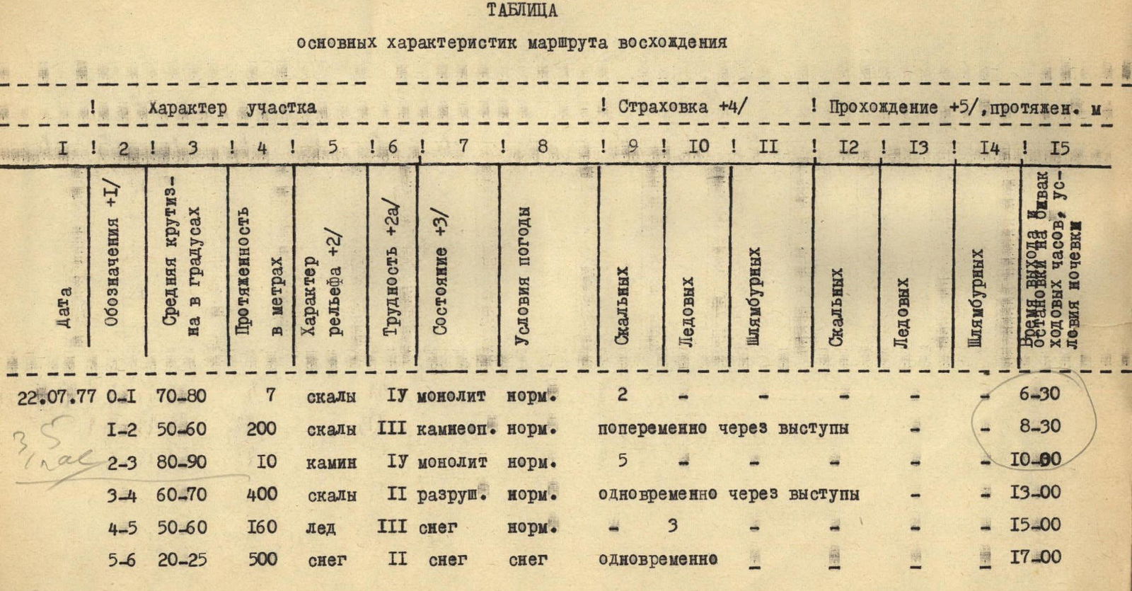
TABLE of main characteristics of the ascent route
| Date | Designation | Average steepness, ° | Length, m | Terrain characteristics | Difficulty | Condition | Weather conditions | Protection: Rock | Protection: Ice | Protection: Bolts | Climbing: Rock | Climbing: Ice | Climbing: Bolts | Time, stops, bivouac, walking hours, overnight conditions |
|---|---|---|---|---|---|---|---|---|---|---|---|---|---|---|
| 22.07.77 | R0 | 70–80 | 7 | rocks | 4 monolithic | normal | – | 2 | – | – | – | – | – | 6:30 |
| – | R1–R2 | 50–60 | 200 | rocks | 3 rockfall hazard | normal | – | alternating through features | – | – | – | – | – | 8:30 |
| – | R2–R3 | 80–90 | 10 | chimney | 4 monolithic | normal | – | 5 | – | – | – | – | – | 10:00 |
| – | R3–R4 | 60–70 | 400 | rocks | 2 fragmented | normal | – | simultaneous through features | – | – | – | – | – | 13:00 |
| – | R4–R5 | 50–60 | 160 | ice | 3 snow | normal | – | – | 3 | – | – | – | – | 15:00 |
| – | R5–R6 | 20–25 | 500 | snow | 2 snow | snow | simultaneous | – | – | – | – | – | – | 17:00 |
Comments
Sign in to leave a comment