ASCENT
To v. SHAVLA-12 from the Abul-Orek pass (approximately 36 km tr.). Completed by a group of climbers from the Altai Regional Federation of Alpinism expedition.
Group Composition
- Bunyaeva V.S. 2nd sports category
- Kuznetsov N.A. 2nd sports category
- Achkasov Yu.I. MS
- Parshennikov A.A. 2nd sports category
- Sannikov A.I. 2nd sports category
Group Leader: BUNYAEVA V.S.
Route Description
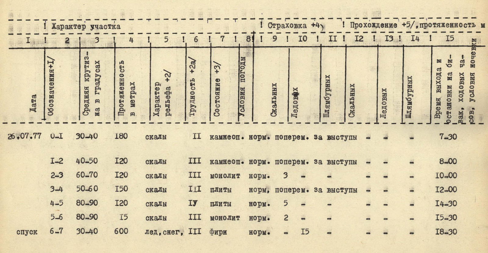
The SHAVLA-12 peak is located in the southwestern part of the North-Chuya Ridge. The group chose a route along the eastern ridge from the Abul-Orek pass. On July 26, 1977, at 5:00, they began the ascent. They followed a trail from the bivouac on Lake Sr. Shavla along a stream, past a waterfall. They bypassed the Upper Shavla Lake to the right. Then, along a barely noticeable trail, to the left of a rock massif, they traversed the tongue of the Left Shavla Glacier, and then climbed a steep snow-ice slope and damaged rocks to reach the Abul-Orek pass. They roped up on the pass.
From the pass, the path followed the edge, along severely damaged rocks. The journey from the base camp to the pass took around three hours.
The first "gendarme" on the edge is traversed on the left along a good, wide ledge (about two ropes). Further up, through damaged rocks, with climbing of moderate difficulty and intermittent belays.
The second "gendarme" is traversed on the right. Climbing is of moderate difficulty - about three ropes. After the second "gendarme," one exits to the left along inclined slabs onto the edge. Belays are made through ledges.
The third "gendarme" is climbed "head-on." Belays are made with pitons, intermittently. Three ropes. (It is possible to bypass this "gendarme" on the left along ledges). Further along the ridge, the rocks are severely damaged. Before the fourth "gendarme," there are slabs. They are traversed with intermittent belays through ledges.
The fourth "gendarme" is traversed on the left along severely damaged rocks - three ropes. Further up, through damaged rocks.
Ahead lies a wall composed of two- to three-meter slabs. The slope is 80-90°, and the height is around 120 m. This is the key section of the route. Climbing is challenging, and the difficulty lies in organizing belays - the slabs are monolithic, with virtually no cracks. Belays are made with pitons.
After the wall, climbing is of moderate difficulty. Before reaching the pre-summit ridge, there is a 15-meter rappel down a sloping slab. From the depression, one climbs to the right through rocks of moderate difficulty - four ropes. This leads to the pre-summit ridge. Along the pre-summit ridge, through rocks of moderate difficulty, with simultaneous belays through ledges, one reaches the summit.
The descent from the summit towards the Left Shavla Glacier is along a steep snow-ice slope. Crampons are necessary. Intermittent belays are required. The descent route is clearly visible when approaching the Abul-Orek pass.
The entire route takes 13-14 hours to complete.
Conclusion on Route Difficulty
The route was completed in 14 hours: 11 hours for the ascent and 3 hours for the descent. 10 rock pitons and 15 ice screws were used.
The route is combined, technically challenging, and requires good physical and technical preparedness from the participants.
The group evaluates the route as category 3B complexity