Ascent Certificate
- Altai, Severo-Chuyskie Belki ridge, Aktru gorge, section 1.2.
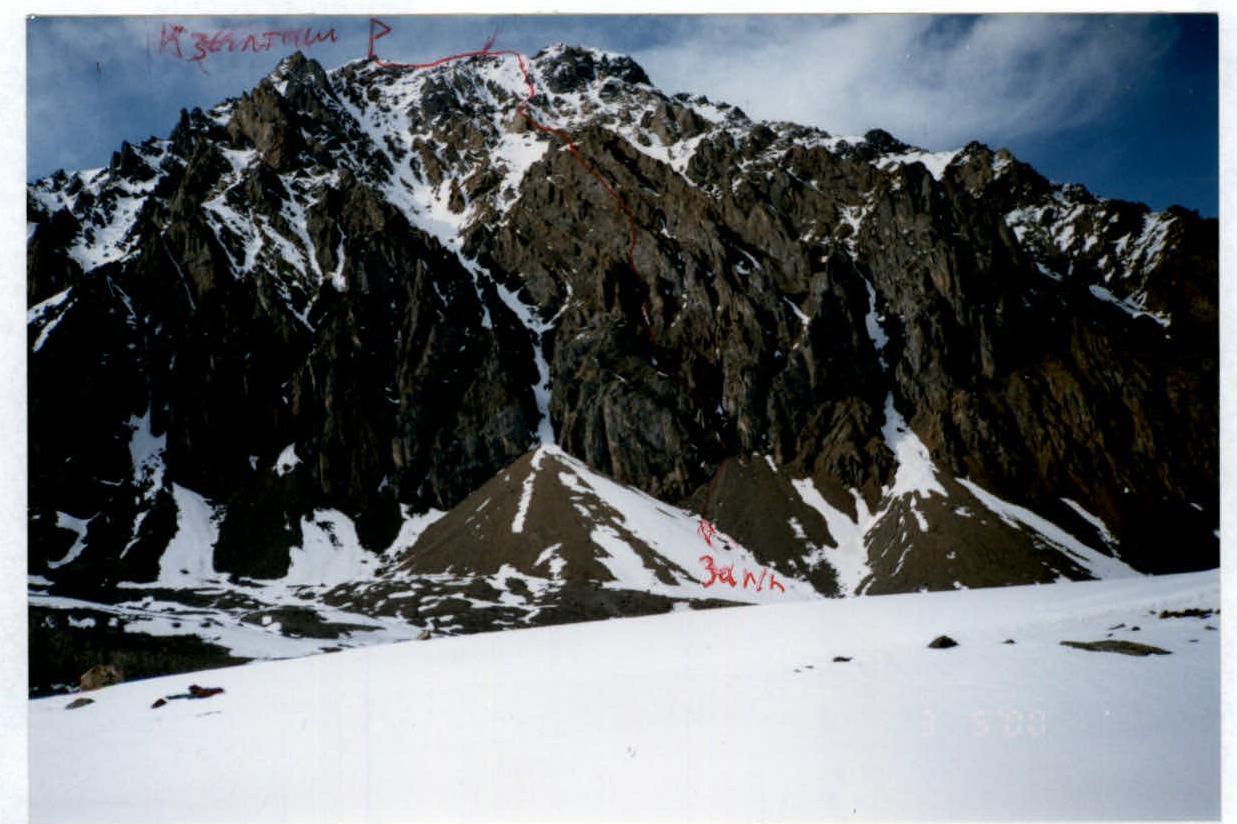
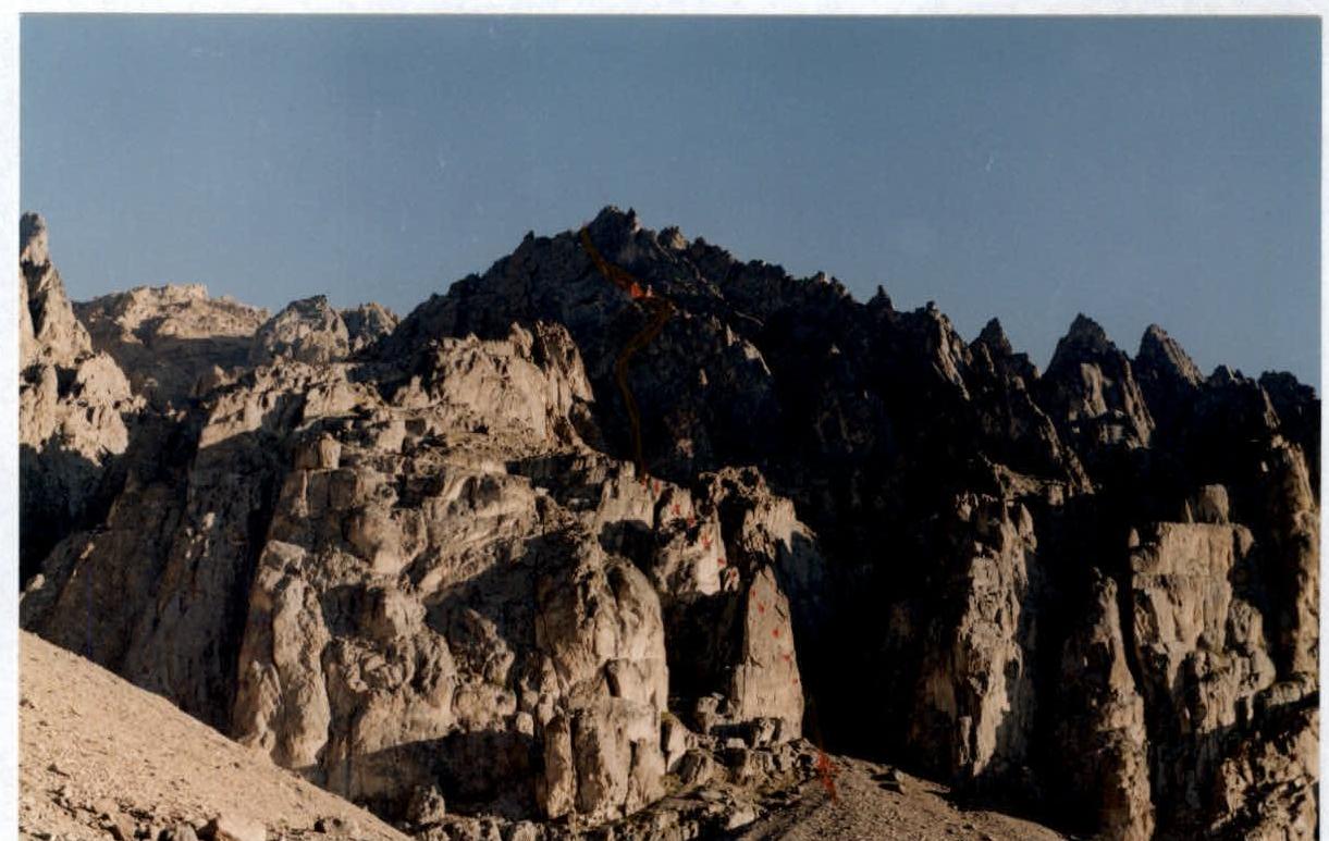
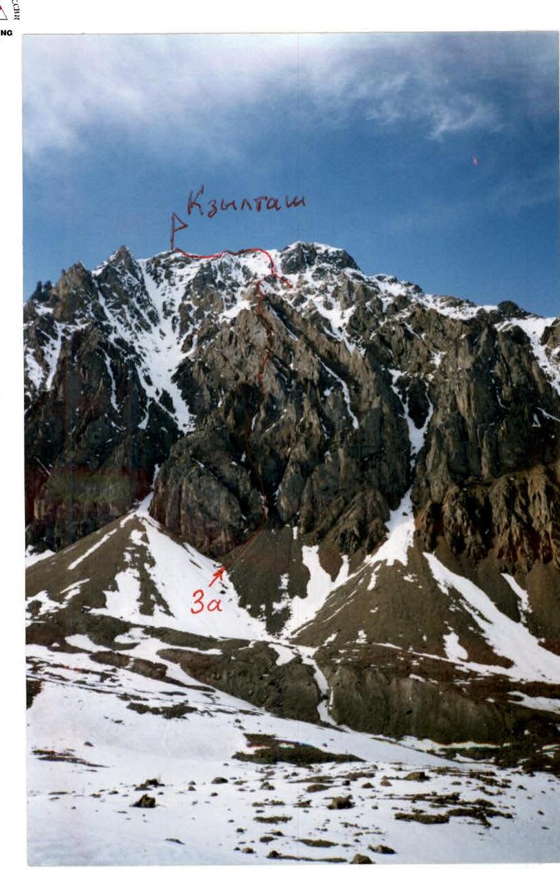
- Kzyl-Tash peak 3486 m, via the middle ridge of the Southern slope.
- Proposed category: 3A.
- Route type: rock.
- Height difference 900 m, length 1400 m, average steepness of the main part of the route 40°.
- Pitons used: rock and chocks — 15 pieces.
- Team's travel time 8 hours.
- No overnight stays.
- Leader: Afanasyev A.E., Master of Sports Team members: Kolesnikov I.E., Candidate for Master of Sports Morozov R.V., 1st sports category Novitsky O.E., 1st sports category Surazakov A.B., 2nd sports category
- Coach: Afanasyev A.E.
- Departure to the route and return — May 4, 2000.
Route Description for Ascending Kzyl-Tash peak 3486 m via the middle spur of the Southern slope, cat. 3A
The approach to the route begins on the trail leading to Goluboe Lake, short of Znakhi clearing. From the trail, one needs to cross the left lateral moraine of the 19th century. The middle spur of the Southern slope is outlined on both sides by nearly сквозными couloirs. The talus cone of the right couloir is light-colored, and the left one is dark-colored. Between these two talus cones, there is another smaller dark-colored one located at the foot of the middle spur. The starting point of the route is at the apex of this talus cone.
Sect. R0–R1 180 m. 40° 2. Snow couloir. Cairn. Sect. R1–R2 150 m. 40° 2. Traverse right, ruined rocks. Approach to the wall section, cairn. Sect. R2–R3 30 m. 50° 2. Narrow ledge from left to right on a vertical wall into a narrow couloir. Sect. R3–R4 30 m. 50° 3. Couloir in a narrow crevice. At the end of the section — a 7-meter icicle. Sect. R4–R5 20 m. 65° 4. Wall in an inner corner with ice. Sect. R5–R6 120 m. 40° 1. Talus ledge left-up to a snow couloir. Cairn under an overhang. Sect. R6–R7 100 m. 45° 2. Snow couloir. Cairn. Sect. R7–R8 40 m. 45° 3. Across ruined rocks to the right onto the ridge. Sect. R8–R9 140 m. 45° 2. Snow couloir. Sect. R9–R10 30 m. 35° 1. Talus ridge. On a gendarme, a control cairn before a sharp rocky ridge. Sect. R10–R11 80 m. 40° 3. Rocky knife-edge. Sect. R11–R12 40 m. 55° 3. Descent onto a snow col. Sect. R12–R13 100 m. 40° 2. System of low, ruined, snow-covered ridges. Sect. R13–R14 3 m. 90° 4. Collapsed snow cornice. Junction with the route from Uchitel pass (3A cat.), before the last gendarme. Sect. R14–R15 200 m. Along the ridge, bypassing the black gendarme to the right, under the summit tower. Sect. R15–R16 25 m. 80° 4. Chimney with ice. Summit. Descent via the 1B category route through Konteiner pass.
Mt. Kzyl-Tash 3486 m, via the middle ridge of the Southern slope, cat. 3A.
| Rock and chock placements | Ice and snow anchors | Sections | Length | Steepness |
|---|---|---|---|---|
| R16 | ||||
| 3 | R15 4 | 25 m | 80° | |
| 1 | R14 | 200 m | ||
| R13 4 | 3 m | 90° | ||
| R12 2 | 100 m | 40° | ||
| R11 desc | 40 m | 55° | ||
| 4 | R10 3 | 80 m | 40° | |
| R9 1 | 30 m | 35° | ||
| R8 2 | 140 m | 45° | ||
| 1 | R7 3 | 40 m | 45° | |
| R6 2 | 100 m | 45° |
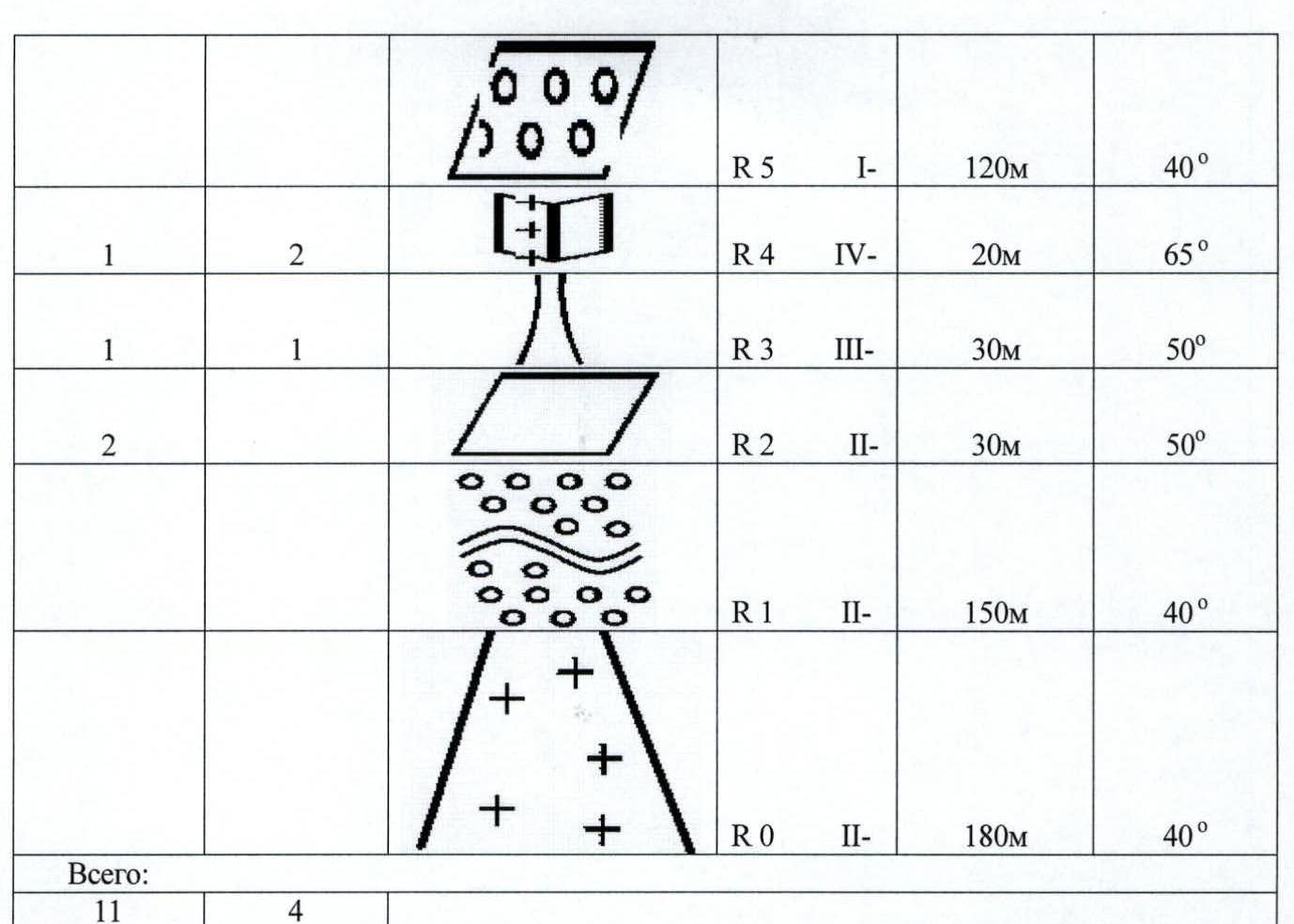
| Rock and chock placements | Ice and snow anchors | Sections | Length | Steepness |
|---|---|---|---|---|
| 1 | 2 | R5 1 | 120 m | 40° |
| 1 | 1 | R4 4 | 20 m | 65° |
| 2 | R3 3 | 30 m | 50° | |
| R2 2 | 30 m | 50° | ||
| R1 2 | 150 m | 40° | ||
| R0 2 | 180 m | 40° | ||
| Total: | ||||
| 11 | 4 |
- Kzyl-Tash M-T 3A
Start of M-T
Mt. Kzyl-Tash M-T 3A

Sect. 5