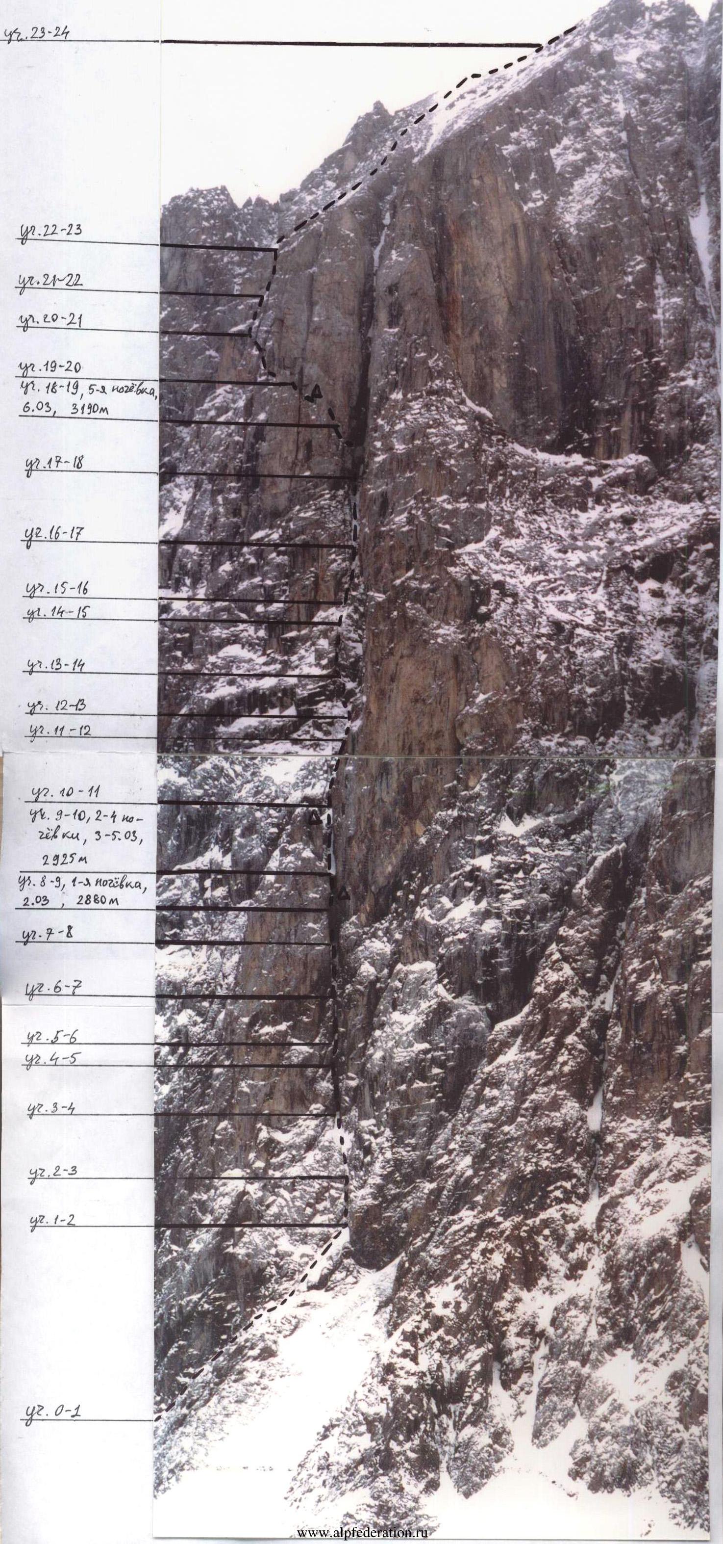
Ascent Passport
- Climbing area — Altai, Aktru gorge, section number according to KMGV — 1.2.
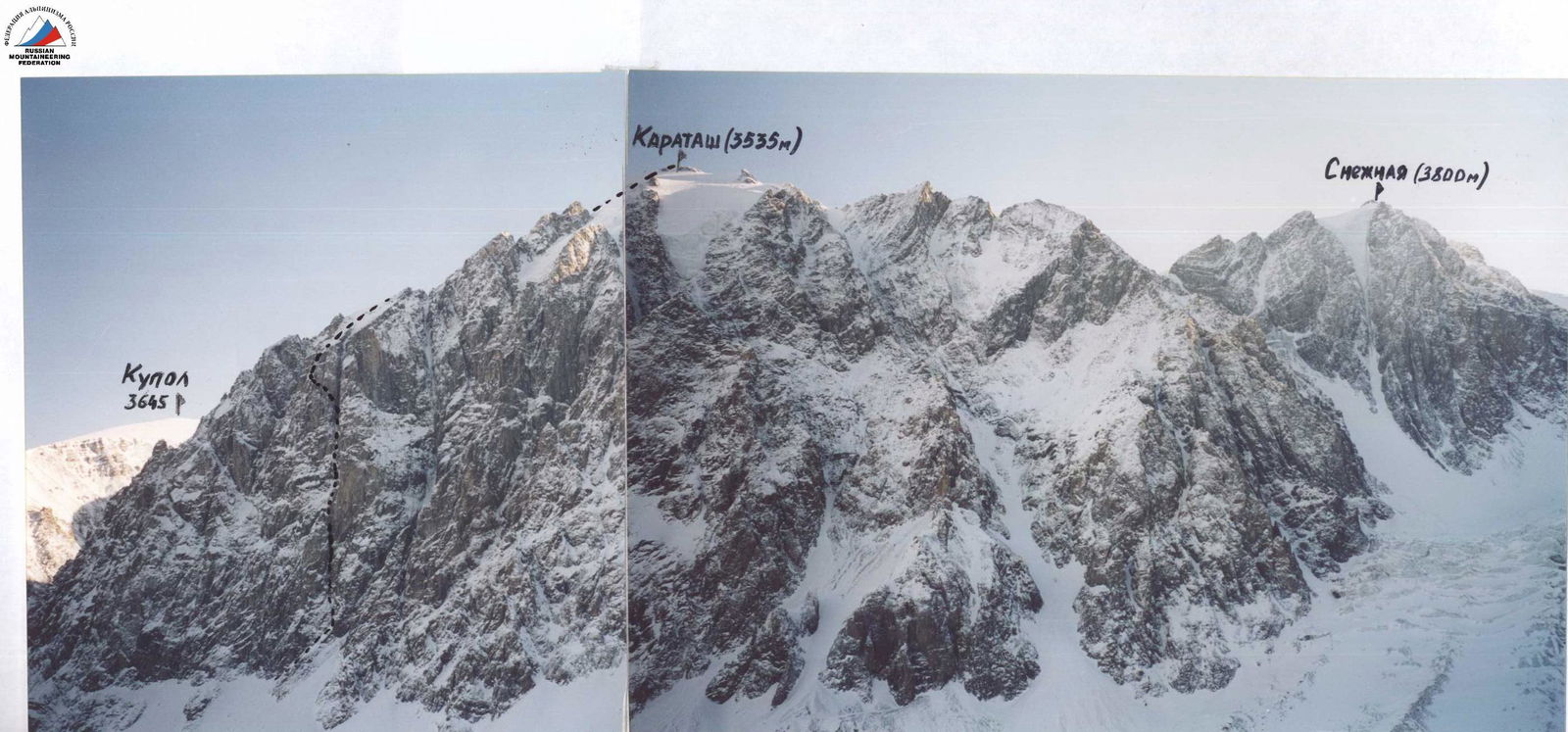
- Name of the peak: Karatash, via the left part of the North face.
- Proposed 5B category of difficulty, first ascent.
- Nature of the route — combined.
- Height difference of the route — 940 m.
Route length — 1230 m. Length of sections with 5 and 6 category of difficulty — 305 m. Average steepness:
- main part of the route — 61°
- entire route — 50°
- Pitons left on the route: total — 5, including bolted — 2.
Used on the route in total:
- rock pitons — 28
- chocks and similar — 112. Pitons used on the route:
- stationary bolted — 2, including for artificial aids — 0
- removable bolted — 1, including for artificial aids — 1. Total artificial points of support (AID) used — 105.
- Team's travel hours: 78 hours, 10 days.
- Leader: Ermilov A.A., 1st category.
Team members:
- Kuvakin A.A., 1st category
- Praslov S.V., 1st category
- Rusakov A.V., 1st category.
-
Coach: Zuev S.V., CMS.
-
Reconnaissance: February 24–25 and February 28–March 1, 2003.
Departure onto the route: 6:00, March 2, 2003. Reached the summit: 16:00, March 7, 2003. Returned to base camp: 19:00, March 7, 2003.
General photo of the summit

Route scheme in UIAA symbols
| Section № | Pitons | ||||
|---|---|---|---|---|---|
| rock | chocks | ice | |||
| 24–25 | - | - | - |  | 1, 50 m, 20° |
| 23–24 | - | - | - |  | 2, 100 m, 45° |
| 22–23 | - | - | - |  | 1, 200 m, 30° |
| 21–22 | 1/1 | 13/11 | - |  | 5+, 50 m, 80°, A2 |
| 20–21 | - | 4 | - | 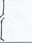 | 4, 50 m, 60° Photo № 6 |
| 19–20 | 1/1 | 6/3 | - |  | 5, 30 m, 75°, A1 |
| 18–19 | - | - | - |  | 3, 50 m, 50° |
| 17–18 | - | 4 | - | 4–, 40 m, 65° | |
| 16–17 | - | - | - | 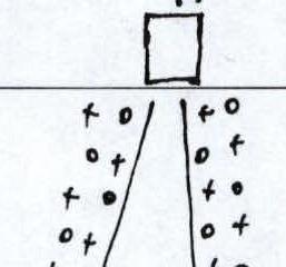 | 2–, 50 m, 30° |
| 15–16 | 3/2 | 13/13 | - | 5, 40 m, 80°, A2 | |
| 14–15 | - | - | - | 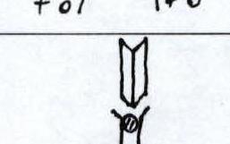 | 2+, 20 m, 35° |
| 13–14 | 3/3 | 13/13 | - | 5, 35 m, 75°, A3 | |
| 12–13 | 3/2 | 5/3 | - | 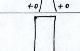 | 4–, 30 m, 50°, A1 |
| 11–12 | - | - | - |  | 2–, 25 m, 20° |
| 10–11 | 4/2 | 14/12 | - |  | 5+, 50 m, 70°, A2 |
| 9–10 | 1 | - | - | 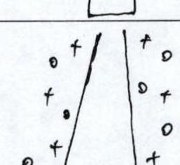 | 2, 60 m, 40° |
| 8–9 | - | 9/6 | - | 6–, 20 m, 85°, A3 | |
| 7–8 | 1/1 | 9/9 | - | 6+, 20 m, 110°, A3e | |
| 6–7 | 1 | 2/2 | - | 3, 30 m, 60°, A1 | |
| 5–6 | 3/2 | 7/6 | - | 5, 70°, 30 m, А2 | |
| 4–5 | 2/1 | 7/6 | - | 6, 10 m, 95°, A3 | |
| 3–4 | 1 | 3/1 | - | 5+, 20 m, 85°, A1 | |
| 2–3 | - | - | - | 2–, 35 m, 40° | |
| 1–2 | 4/3 | 3/1 | - | 4–, 35 m, 60°, А1 | |
| 0–1 | - | - | - | 2+, 150 m, 45° |
Brief description of the route
| 0–1 | 2+, 150 m, 45° "Ram's foreheads". Along the wall to the start of the chimney. |
|---|---|
| 1–2 | 4–, 35 m, 60°, А1 Chimney narrowing into a crack and transitioning into a wall. Piton protection. Sparse AID. |
| 2–3 | 2–, 35 m, 40° Snow and scree gully leading to a large chimney. Station on a shelf to the right. |
| 3–4 | 5+, 20 m, 85°, А1 Almost vertical chimney. Passed with body pressure. |
| 4–5 | 6, 10 m, 95°, А3 Overhanging wall. AID mainly on stoppers and friends. Narrow ledge at the exit. Station on a piton and a bolt. |
| 5–6 | 5, 70°, 30 m, А2 Narrow chimney. Body pressure, short series of AID. Bolt for protection. |
| 6–7 | 3, 30 m, 60°, A1 Chimney widens and becomes less steep. Many loose rocks. Station under a large boulder on a ledge and on stoppers. Control marker № 1. |
| 7–8 | 6+, 20 m, 110°, A3e. Up the left, slightly overhanging wall of the chimney, through a crack directly under the boulder. Then to the right into a hole through a strong overhang. Solid AID. Used a removable bolted piton. |
| 8–9 | 6–, 20 m, 85°, A3 Exit onto the boulder. Many options for setting up a station. Forced, uncomfortable bivouac here. Further, a strongly overhanging short wall. Passed to the right via a corner. AID on chocks (friends of various sizes). Section 7–9 is the key part of the route. |
| 9–10 | 2, 60 m, 40° Simple snow gully. Leads to a shoulder, from which the further perspective of the route opens. Ideal place for a bivouac. |
| 10–11 | 5+, 50 m, 70°, А2 From the base of the shoulder along the right wall. "Ram's foreheads". Many AID. Good place to set up a station. |
| 11–12 | 2–, 25 m, 20° Simple snow slope. |
| 12–13 | 4–, 30 m, 50°, А1 "Ram's foreheads". Inclined ledge. Piton station. |
| 13–14 | 5, 35 m, 75°, A3 Wall with a system of cracks for various gear. |
| 14–15 | 2+, 20 m, 35° Snow and scree gully leading to a chimney. Convenient station on a ledge to the left of the chimney entrance. |
| 15–16 | 5, 40 m, 80°, А2 Very steep and complex, widening chimney with a boulder at the top. Complex AID. Above, a small steep wall. |
| 16–17 | 2–, 50 m, 30° Long, simple gully leading under a huge boulder at the entrance to the upper large chimney. Station on chocks at the start and end. |
| 17–18 | 4–, 40 m, 65° Up the left side of the chimney to the boulder. Station on a rock a bit higher and control marker № 2. From it, up through a crack via free climbing. |
| 18–19 | 3, 50 m, 50° Uncomplicated terrain bypassing a bastion. Forced bivouac in a niche between rocks. , 150 m, 45° "Ram's foreheads". Along the wall until the start of the chimney. |
| 1–2 | 4–, 35 m, 60°, A1 Chimney, narrowing to a crack and turning into a wall. Piton protection. Sparse AID. |
| 2–3 | 2–, 35 m, 40° Snow and scree gully, leading to a large chimney. To the right, on a shelf — a station. |
| 3–4 | 5+, 20 m, 85°, A1 Almost vertical chimney. Passed with body pressure. |
| 4–5 | 6, 10 m, 95°, A3 Overhanging wall. AID mainly on stoppers and friends. Narrow ledge at the exit. Station on a piton and a bolt. |
| 5–6 | 5, 70°, 30 m, A2 Narrow chimney. Body pressure, short series of AID. Bolt for protection. |
| 6–7 | 3, 30 m, 60°, A1 Chimney widens and becomes less steep. Many loose rocks. Station under a large boulder on a ledge and on stoppers. Control marker № 1. |
| 7–8 | 6+, 20 m, 110°, A3e. Up the left, slightly overhanging wall of the chimney, through a crack directly under the boulder. Then to the right into a hole through a strong overhang. Solid AID. Used a removable bolted piton. |
| 8–9 | 6–, 20 m, 85°, A3 Exit onto the boulder. Many options for setting up a station. Forced, uncomfortable bivouac here. Further, a strongly overhanging short wall. Passed to the right via a corner. AID on chocks (friends of various sizes). Section 7–9 is the key part of the route. |
| 9–10 | 2, 60 m, 40° Simple snow gully. Leads to a shoulder, from which the further perspective of the route opens. Ideal place for a bivouac. |
| 10–11 | 5+, 50 m, 70°, A2 From the base of the shoulder along the right wall. "Ram's foreheads". Many AID. Good place to set up a station. |
| 11–12 | 2–, 25 m, 20° Simple snow slope. |
| 12–13 | 4–, 30 m, 50°, A1 "Ram's foreheads". Inclined ledge. Piton station. |
| 13–14 | 5, 35 m, 75°, A3 Wall with a system of cracks for various gear. |
| 14–15 | 2+, 20 m, 35° Snow and scree gully leading to a chimney. Convenient station on a ledge to the left of the chimney entrance. |
| 15–16 | 5, 40 m, 80°, A2 Very steep and complex, widening chimney with a boulder at the top. Complex AID. Above, a small steep wall. |
| 16–17 | 2–, 50 m, 30° Long, simple gully leading under a huge boulder at the entrance to the upper large chimney. Station on chocks at the start and end. |
| 17–18 | 4–, 40 m, 65° Up the left side of the chimney to the boulder. Station on a rock a bit higher and control marker № 2. From it, up through a crack via free climbing. |
| 18–19 | 3, 50 m, 50° Uncomplicated terrain bypassing a bastion. Forced bivouac in a niche between rocks. |
| 19–20 | 5, 30 m, 75°, A1 From the edge of a ledge up a steep wall on AID along the left crack. Crossing a very steep gully, transition to a ledge on a counterfort. Station on a ledge. |
| 20–21 | 4, 50 m, 60° To the left, parallel to the gully, a chimney passed via free climbing with body pressure. Station on a ledge. Chimney transitions into an internal corner. |
| 21–22 | 5+, 50 m, 80°, A2 Steep chimney with an overhanging boulder. Bypassed to the right via a wall, mainly on AID. Here, the chimney converges with the gully crossed below, which turns into an internal corner. Much AID. |
| 22–23 | 1, 200 m, 30° Simple scree slope leading to the ridge. |
| 23–24 | 2, 100 m, 45° "Gendarme" on the ridge, bypassed to the left. Simultaneous movement. |
| 24–25 | 1, 50 m, 20° Gentle ridge. Summit. Section 23–25 coincides with routes of 3B, 3A category of difficulty. |
Technical photograph of the route
Recommendations for passing the route
From Aktru base camp, follow along the left bank of the river to approach the route in 2 hours.
Necessary:
- cross the avalanche-prone area of the left icefall of the north face
- ascend the 300-meter snow incline to the base of the wall.
The route in its lower and middle parts follows a characteristic fault line crossing the left part of the wall from bottom to top. In the upper part, the route line turns left, bypassing a bastion.
The usual set of gear was used on the route: rock pitons, stoppers, friends.
The presence of anchor pitons can speed up the passage of the route, especially in winter conditions.
The route is prone to rockfall, so an ascent by a small group is recommended. Movement on ropes on many sections is very dangerous during work on upper sections by the leader or other participants. However, all stations were set up in safe locations.
Photo illustration of the report
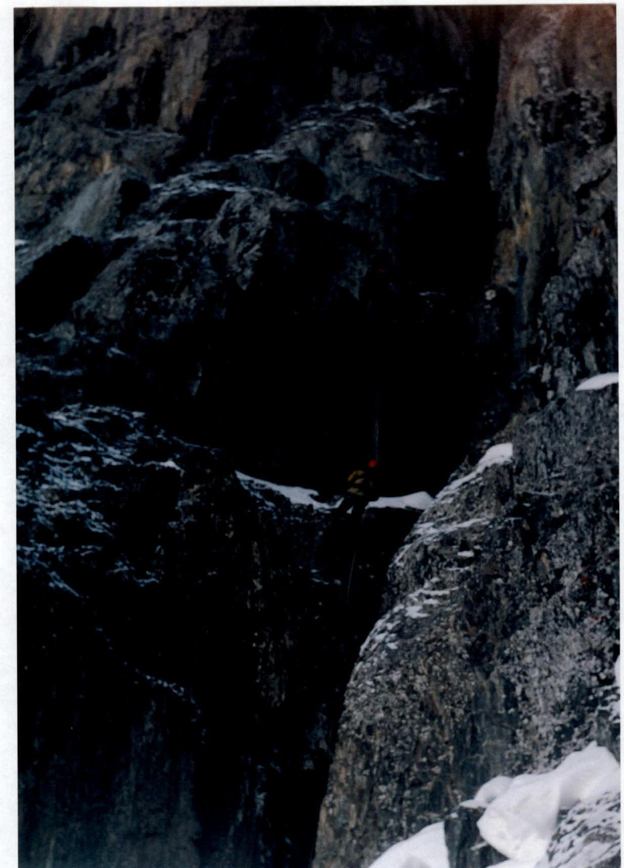
Photo № 1. Passage of sections R3–R4 and R4–R5.
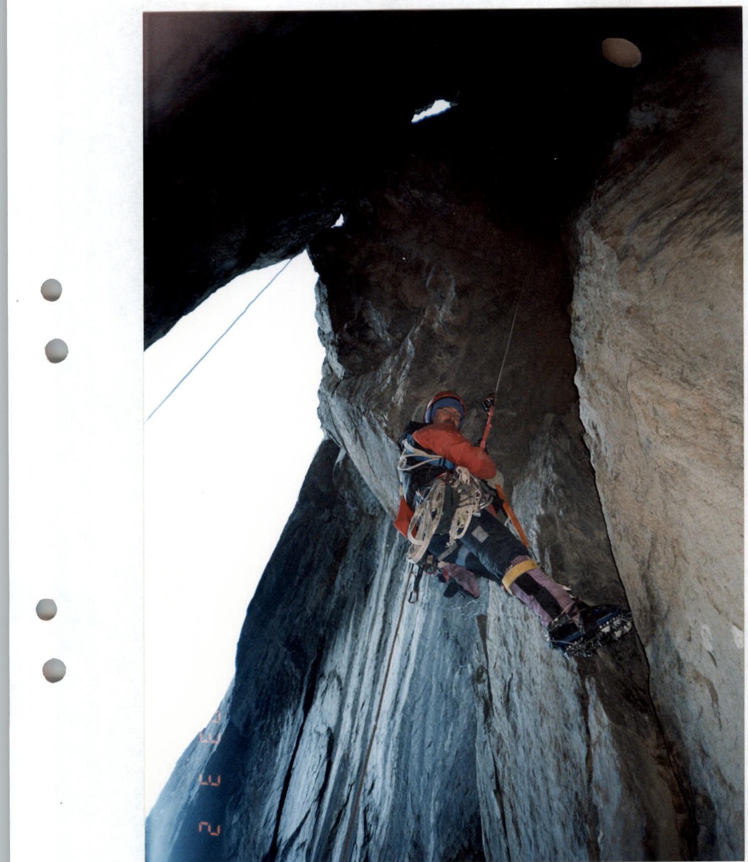
Photo № 2. Section R7–R8
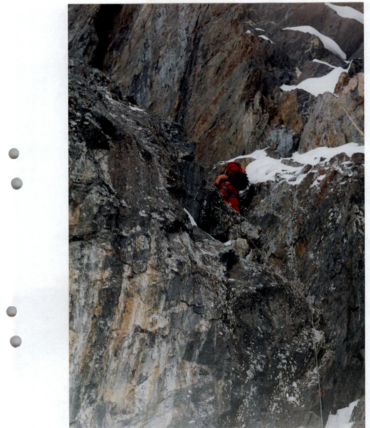
Photo № 3. Section R10–R11
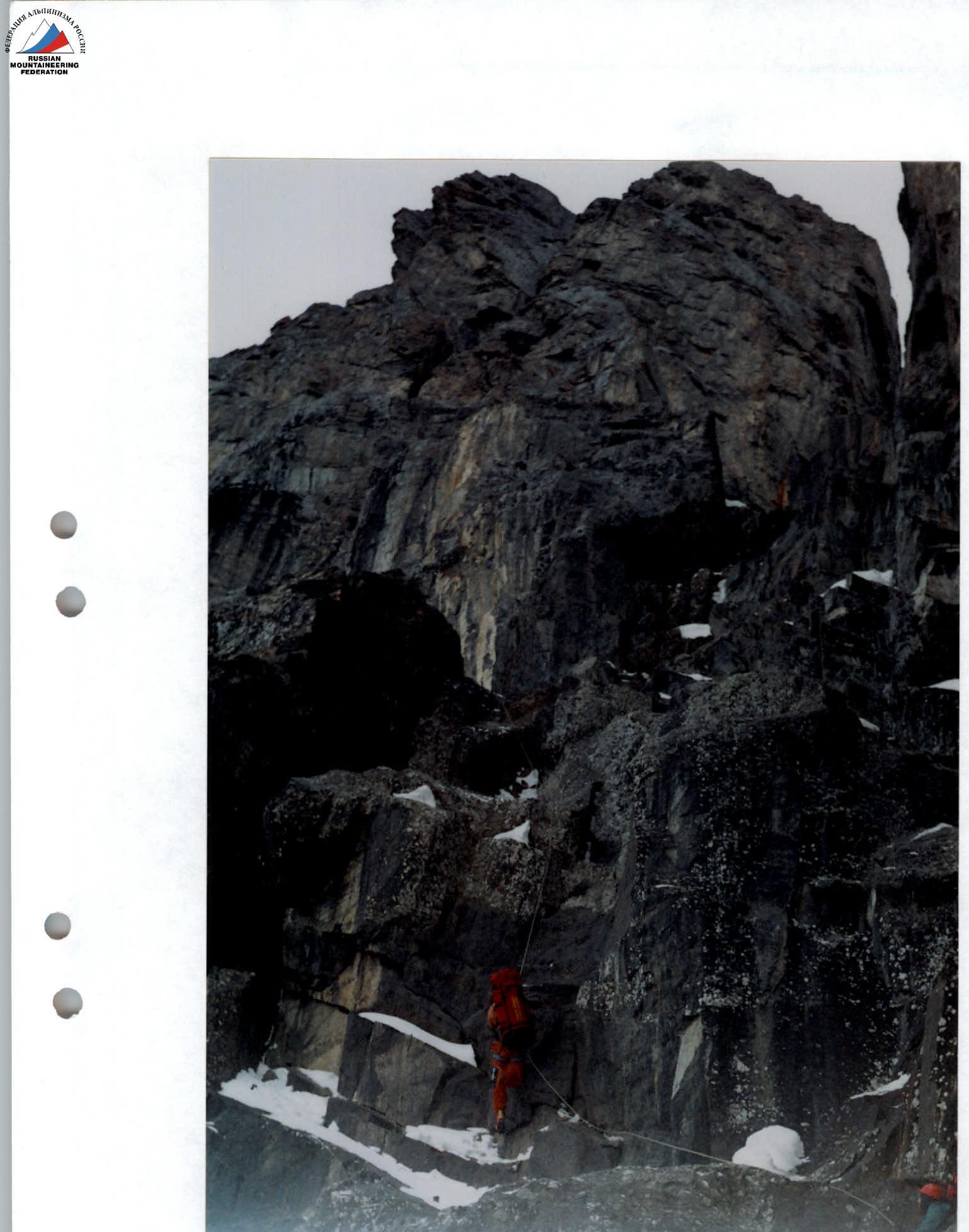
Photo № 4. Section R13–R14
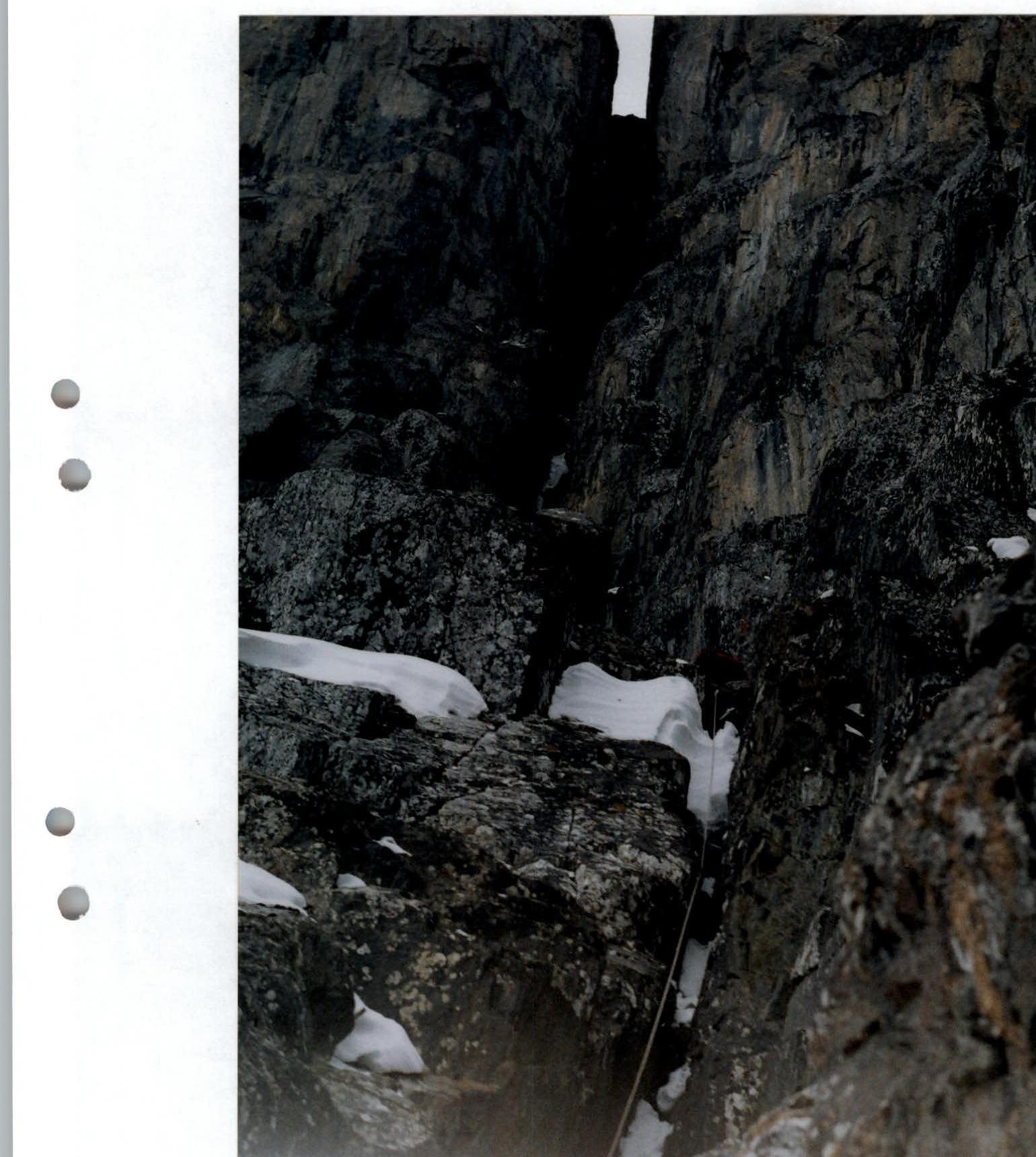
Photo № 6. Sections R20–R21 and R21–R22