1.2.18
Description of the First Ascent of the Left Buttress of the Eastern Peak of Karagem-bash (August 7-11, 1965)
The Karagem-bash peak (3972 m) is located in the central ridge of the North-Chuya Mountains of the Altai. The massif of this peak, stretching in the latitudinal direction, bounds one of the largest glaciers of the Altai - the Maashey Glacier (10 km long, 15 km² in area) from the south. To the west of Karagem-bash, in the same ridge, stands the massif of the Maashey peak (4250 m), which is the highest point of the North-Chuya Alps. To the east, the ridge from the Karagem-bash peak goes to the Tammy peak, from where it turns north to the Maashey Pass. To the south from the peak descend numerous extensive glaciers, giving rise to the Karagem River. To the north (towards the Maashey Glacier), the Karagem-bash peak is cut off by a one-and-a-half-kilometer wall. From the ice cap of the peak to the north hang seracs, separated by steep rocky buttresses. The falls of these seracs occur along the lower sections of these buttresses, where they are less steep.
The Left Buttress has a northern aspect and is lit by the sun in its lower part approximately from 10:00. To the right of the buttress pass routes of 5B category of difficulty along the northern walls:
- the eastern peak of Karagem-bash
- the western peak of Karagem-bash.
The reconnaissance of the route and its study were conducted by the group during a separate trip to the upper reaches of the Maashey gorge. The path taken fully coincided with the planned one. The group considered that the route should be 5B category of difficulty, but it turned out to be more difficult due to the upper part, which was poorly visible from below.
The ascent was conducted from the Ak-Tru tourist camp. From the camp, the group departed on August 7 in the direction of the moraine lake on the Big Aktru Glacier. The group was caught by bad weather at the lake, and the further path through the Maashey Pass took place in heavy meteorological conditions: continuous fog with snowfall and wind. Due to the bad weather, not reaching the upper serac of the Maashey Glacier, the group set up a bivouac.
August 8. The group departed from the bivouac at 8:00. The weather was good, clear. At 10:00, the group approached the base of the buttress and until 12:30 finally clarified the route. At 12:30, the group began the ascent along the right edge of the wide scree couloir, located to the left of the base of the buttress. The right part of this couloir is not prone to rockfall, while the middle and left parts of the couloir are exposed to rocks and ice fragments from the serac located above the couloir. Having passed about 100 m along the couloir, they went out to the right onto scree ledges, along which they approached the first wall. The general direction of movement is towards the slabs leading to the ridge of the buttress.
Characteristics of the route sections:
- The height of the first wall is 12-15 m. 1 rock anchor was hammered.
- Further path along the ledge to the base of the chimney, 70-80 m long (two ropes of 40-50 m), leading to the lower part of the slabs.
- On the first rope, 2 rock anchors were hammered.
- On the second - 3.
- The second rope was climbed without backpacks with subsequent pulling of them.
It is possible to bypass the chimney on the left along a wide ledge, leading to the base of the slabs. However, this route is prone to rockfall, and the group does not recommend it.
Along the slabs with a steepness of about 40-45°, exit to the right onto the ridge of the buttress (three ropes of 40 m). 3 rock anchors were hammered. On the ridge, the first control cairn was built. The group reached the ridge at 15:00.
From the cairn, the path goes straight along the ridge to the base of the gray wall, 30 m high. This wall leads to an inclined slab, 10 m long. 3 rock anchors were hammered. The slab leads to a small (2 m) overhanging plug, the exit to which is made without backpacks. Further, the path goes along the ridge along large, destroyed rocks of medium difficulty. Insurance is mostly variable. Many loose rocks. The encountered "gendarmeres" are bypassed, mainly to the right, along the way.
At 18:00, they built the second control cairn on the ridge, approximately at the level of the beginning of the snowpatch approaching the ridge from the left. Further on the ridge, a large red "gendarme" is encountered, which is bypassed to the right along the ledges with alternate insurance. The ledges lead to a scree-filled, snow-covered couloir, the ascent along which goes in its left part, along the way. The couloir leads to a saddle connecting the main ridge and a short spur buttress extending from it to the left. On the upper shoulder of the buttress, at 19:30, a bivouac was set up.
August 9. From the bivouac, the path for about 150 m goes along a sharp, heavily destroyed, dangerous ridge to the base of the 100-meter Red Tower. This is the key point of the route. The right part of the tower is represented by smooth, concave slabs of red color. The left part breaks off towards the hanging glacier with gray walls. The path goes along the junction of the left and right parts of the tower and represents a sharp outer corner with a steepness of 60°. The sides of the corner are smoothed, there are few handholds, the rocks are of a slabby structure and unreliable. On the first rope, 6 rock anchors were hammered. Movement was without backpacks with subsequent pulling of them. The next 20 m go to the left of the edge of the outer corner of the tower along a narrow chimney, along which the group passed with ladder placement. 4 rock anchors were hammered. When exiting the chimney onto the ledge, there are many "live" rocks. Maximum caution is needed when securing and pulling up backpacks. Further ascent continued along the outer corner for 30 m. There are few handholds, the rocks are smoothed, 2 ice anchors were hammered into the rocks and 1 rock anchor. This section was also passed by the group without backpacks. The upper gray rock ascent (about 20 m) is bypassed to the right along a scree ledge for 40 m under a three-meter slab, along which they go out to the left and upwards onto the ridge. They hammered 3 rock anchors. The further path (about 100 m) goes along a heavily destroyed ridge with alternate insurance. A bivouac was set up on the shoulder of the ridge at 19:30. This section of the route took the group 10 hours of work.
August 10. Departure from the bivouac at 8:00. At the bivouac site, the third control cairn was built. From the bivouac, the ascent to the ridge and further along the heavily destroyed rocky ridge with alternate insurance. The encountered gendarmes are bypassed to the right. The ridge, 100-150 m long, leads to the beginning of the ice slope of the peak. The exit to the pre-summit snow plateau passes along the ice slope with an average steepness of 50-60°, 80-100 m high. When overcoming this section, 5 ice anchors were hammered. Along the snow plateau, the group approached the base of the snow-ice dome of the peak. In places, the steepness of the slope reaches 50°; 4 ice anchors were hammered. Further along the snow ridge, the exit to the peak. From the beginning of the ice dome to the peak, the height difference is 400-500 m. The group was on the peak at 17:00.
Descent from the peak along the route of 3A category of difficulty. Having descended from the ridge, at 19:30, the group bivouacked on the Karagem Plateau.
August 11. Having departed from the bivouac at 7:00, having passed the Tammy peak and the Maashey Pass, the group descended to the Ak-Tru tourist camp by 14:00.
Overall Assessment of the Route and Features of the First Ascent
- The calculation of the time taken for the route by days and hours was as follows:
- 1 day (approach) — 10 hours
- 2 day — 11.5 hours
- 3 day — 10 hours
- 4 day — 11.5 hours
- 5 day (return to camp) — 7 hours Total — 50 hours; including on the main route (ascent along the buttress) — 27 hours.
- During the ascent, they hammered:
- into rocks — 26 rock anchors and 2 ice anchors;
- into ice — 9 anchors.
- On the main route, the weather was good. In bad weather, the passage of the route will be significantly complicated.
- The snow-ice part of the route was greatly complicated due to the low snow cover in the area this year: a large number of ice sections covered with a thin layer of loose snow!
- The group evaluates the route as 5A category of difficulty.
Group Composition
- Shilyansky G. A. — leader, 1st sports category, Barnaul.
- Zlotnik B. M. — participant, 1st sports category, Moscow.
- Gudkov V. P. — participant, 2nd sports category, Nalchik.
- Malkin V. E. — participant, 2nd sports category, Moscow Region.
Comparative Characteristics of the Route
The route to Karagem-bash along the left buttress is characterized by a significant number of complex rock sections, as well as their diversity in relief (walls, slabs, corners, chimney, etc.). A large part of the route is represented by steep (up to 60°) snow-ice slopes.
Two participants of the group can compare this route with previously passed routes of 5A category of difficulty, such as, for example:
- Uilpata
- traverse of Tal-gara.
Uilpata
The main route is passed in one day. Fewer complex rock and ice sections. The relative complexity of the route is less.
Traverse of Tal-gara
The main part of the route takes approximately the same amount of time as the presented route. Significantly less rock relief in general, the complexity of which is also inferior to the passed route.
0 0
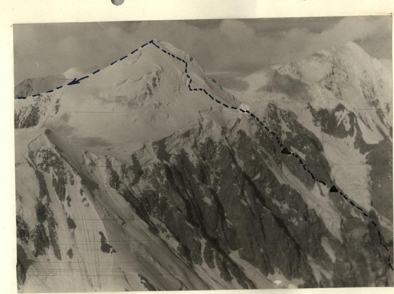 View from the Maashey Pass.
 Photo 1. View of the Karagem-bash peak from the Maashey gorge. The route is indicated by a dashed line.

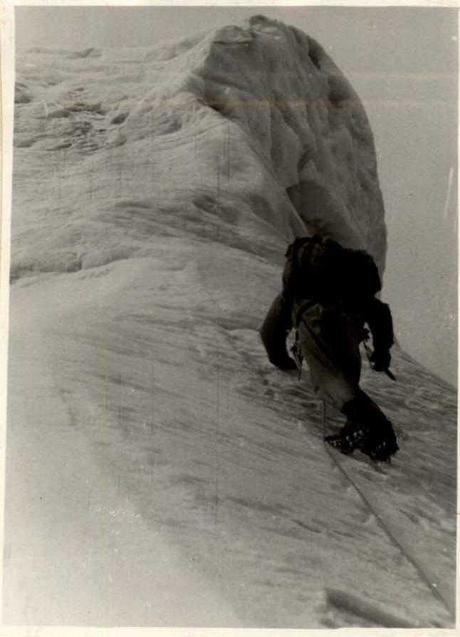 Photo 9. Red Tower.
 Photo 12. Exit from rocks to the snow-ice dome.


