Sports training camp of the Altai Republican Federation of Mountaineering and Rock Climbing, dedicated to the 240th anniversary of the Altai Mountains joining Russia.
Report
On the first ascent to the peak Sodruzhestva (2908 m) via the Eastern ridge by a group of sports training camp of the Altai Republican Federation of Mountaineering and Rock Climbing from Gorno-Altaysk.
Leader and coach of the event: Kindikov E.V. Leader of the ascent: Kindikov E.V. — 1st sports category.
Leader's address: 659700, Altai Republic, Gorno-Altaysk, Kommunistichesky Ave., 172, apt. 39, Eduard V. Kindikov.
Ascent Details
- Ascent area: Altai, Kuragansky spur of the Katunsky ridge, Chechektu gorge.
- Peak: Sodruzhestva (2908 m)
- Route: via the Eastern ridge from the peak Achylgan.
- Proposed: 1B category of difficulty, first ascent
- Elevation gain: H = 300 m.
- Average steepness of the ridge: 10–15°
- Total length: 1000 m.
- Pitons driven: 2 pcs.
- Climbing time: 4–5 hours, 5–6 hours in winter.
- Ascent participants: Karnaukhov A., Kotelanvov Yu., Matin A., Kelyuev V., Mamyev A., Tretyakov S., Burlev V., Grebenkin S., Kyzymyayev V., Saponova T., Ozheredova F.
- Leader of the ascent: Kindikov E.V.
- Approach to the route: February 29, 1996, summit: February 29, return to camp: February 29, 1996.
- Organization: Altai Republican Federation of Mountaineering and Rock Climbing (ARFMC).
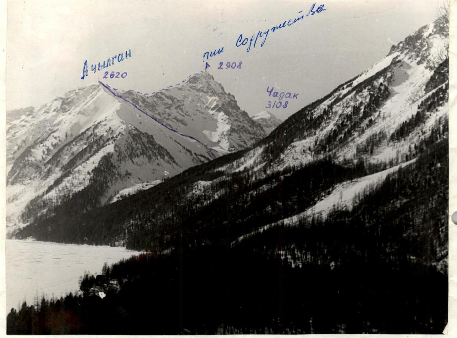
General view of the peak Sodruzhestva. Photo taken in February 1996, using a Zenit camera.

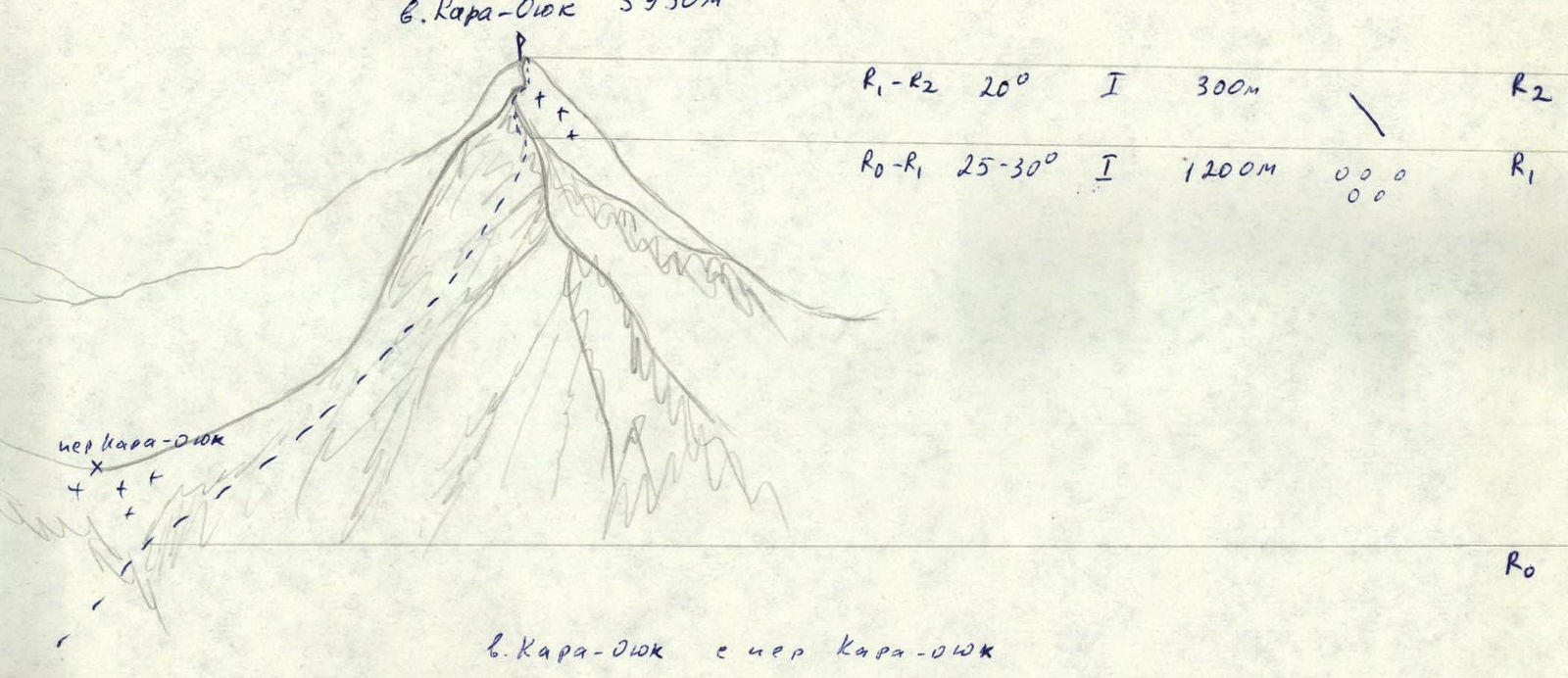
Sketch of the route to peak Kara-Oyuk (3950 m) with sections: R1–R2 (20°, 300 m), R0–R1 (25–30°, 1200 m). View from Kara-Oyuk pass.
General view of the peak Sodruzhestva from the Eastern ridge. Photo taken on the day of the ascent.
Altai Republican Federation of Mountaineering and Rock Climbing
№ 03/03 March 12, 1997
659700, Altai Republic, Gorno-Altaysk, Zarechnaya St., 1-A, phone: 60-76
Peak Sodruzhestva (3120 m)
Ascent via the Eastern Ridge
The pyramidal Peak Sodruzhestva was named by local mountaineers to commemorate the 240th anniversary of the Altai Mountains joining Russia. The peak is located in the north-eastern branch of the Kucherlinskaya horseshoe (Dyarashkolskaya ridge), beyond the peak Achylgan (2680 m), whose eastern slopes descend to the western shore of Kucherlinsky Lake. At the northern lower end of the lake, on the western shore, there is a tourist base "Kucherla", from which the approach to the start of the route should begin.
The approach is made from Kucherlinsky Lake, up the Kul'dor stream (a western tributary of the lake, originating from the Chechektu glacier in the depths of the eponymous gorge), on the southern side of which (near the lake) rise two pointed peaks mentioned above. Cross the stream before it flows into the lake, which is completely hidden under a continuous scree of large stones, and ascend the forested slope to the talus. Then, along the talus, keeping to the left side, ascend to the foot of the extreme northern ridge of the peak Achylgan, from which the Sodruzhestva cirque opens. At the bottom, in the forest zone, is the initial bivouac. From the "Kucherla" tourist base, it takes 3–4 hours.
From the initial bivouac, ascend into the Sodruzhestva cirque, keeping to the slope of the northern ridge of the peak Achylgan, bypassing the forest zone (belt), ascend to the ridge, along which it is easy to reach the peak Achylgan itself, which is the starting point for the ascent to Peak Sodruzhestva.
From the peak Achylgan, along the scree ridge, approach the eponymous pass, from which the eastern ridge of Peak Sodruzhestva begins. Along the easy, destroyed rocky ridge, approach the first rocky ascent, bypass it from the southern side of the ridge, and approach a simple 60° rocky, 10-meter ascent, which is taken head-on (loose rocks, protection). Further along the long, gentle ridge, where rocky outcrops are encountered (bypassed from the southern side), approach the ridge ascent, from which two significant gendarmes are visible. The first gendarme ("Figures of Tents") remains on the side if you start moving towards the second gendarme, bypassing it from the southern side. From the lower simple rocks, alternating with scree short rocky ledges (loose rocks, alternating protection), exit below the second gendarme, bypass it from the southern side, and exit onto the ridge section, where a rocky isthmus is located. Climb simple rocks to reach the summit, where a cairn is built. Descent is made along the ascent route. From the initial bivouac, it takes 7 hours (in winter).
The ascent was made on February 29, 1996.
Leader of the ascent: Kindikov E.V.
Participants:
- Kyzymyayev V.V.
- Mamyev A.I.
- Burlev V.I.
- Kelyuev V.N.
- Matin A.V.
- Kotelanvov Yu.G.
- Grebenkin S.P.
- Saponova T.I.
- Tretyakov S.D.
- Karnaukhov A.
- Ozheredova F.A.

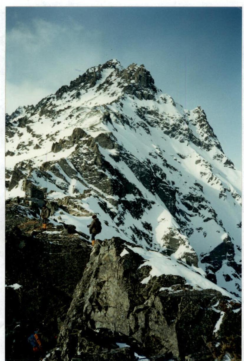
Profile of the Eastern ridge route to peak Sodruzhestva. View of the northern cirque.
- Akylgan pass
- Rocky ascent.
-
-

Gendarme "Figures of Tents". View from the ridge section № 5–6.
Area Map

M 1:200000
Route Description by Sections
R0–R1. The ascent route begins from the peak Achylgan. The route passes along a heavily destroyed, scree, gentle ridge. Movement is simultaneous in rope teams. Length 100 m.
R1–R2. From the saddle of the Achylgan pass, the encountered destroyed rocks are bypassed from the left side. Movement is simultaneous. Length 200 m.
R2–R3. A 10-meter rocky ascent, which stands on the ridge, is taken by free climbing head-on (2). Movement is alternating, protection through rocky outcrops or (ITOs). Caution, loose rocks!
R3–R4. Gentle, destroyed ridge. Encountered destroyed rocks are bypassed from the right side. Movement is simultaneous. Length about 200 m.
R4–R5. Sharp rocky ridge is bypassed from the left side. Free climbing of medium difficulty along encountered rocky ledges. Protection is alternating, through rocky outcrops. Length 120 m.
R5–R6. From the ridge section, a path to the summit opens, which passes on the side of the first gendarme "Figures of Tents", and further along rocky outcrops approaches the pre-summit gendarme. Movement is simultaneous. Protection through rocky outcrops. Length 200 m.
R6–R7. The pre-summit gendarme is bypassed from the left side along rocky ledges. Exit to the pre-summit ridge along easy rocks, then through a snowy ridge isthmus with alternating protection exits to the pre-summit rocky ascent. Exit to the summit. Protection through rocky outcrops. Length 200 m. Descent is made along the ascent route.