Russian Mountaineering Championship
High-Altitude Technical Class
2021
Report
On the First Ascent
to the summit of ShaitanKhana (Kotin Peak) 4521 m via the route on the left inner corner of the western wall, 5B category of complexity, by the team from St. Petersburg, from July 31, 2021, to August 3, 2021.
2021
I. Climbing Passport
| 1. General Information | ||
|---|---|---|
| 1.1 | Full Name, Sports Rank of the Leader | Panov Andrey Olegovich, CMS |
| 1.2 | Full Name, Sports Rank of Participants | Kovalenko Dmitry Olegovich, 1st sports rank; Kochubey Oksana Andreevna, 1st sports rank; Pilshchikova Nadezhda Sergeevna, CMS |
| 1.3 | Full Name of Coach | Tymoshenko Tatyana Ivanovna; Molodozhen Vladimir Aleksandrovich |
| 1.4 | Organization | RSOO Federation of Alpinism of St. Petersburg |
| 2. Characteristics of the Climbing Object | ||
| 2.1 | Region | Pamir-Alay |
| 2.2 | Valley | Karavshin |
| 2.3 | Number of Section According to the Classification Table of 2013 | 5.4.3 |
| 2.4 | Name and Height of the Summit | Shaitankhana (4521 m) |
| 2.5 | Geographical Coordinates of the Summit (Latitude/Longitude), GPS Coordinates | N39.6232 E70.2761 |
| 3. Characteristics of the Route | ||
| 3.1 | Name of the Route | along the left inner corner of the W wall |
| 3.2 | Proposed Category of Complexity | 5B |
| 3.3 | Degree of Route Exploration | first ascent |
| 3.4 | Nature of the Route Terrain | Rock |
| 3.5 | Height Difference of the Route (altimeter or GPS data) | 1120 m |
| 3.6 | Length of the Route (in meters) | 1650 m |
| 3.7 | Technical Elements of the Route (total length of sections of varying complexity with indication of terrain type (ice-snow, rock)) | 2 cat. rock — 200 m. 3 cat. rock — 200 m. 4 cat. rock — 450 m. 5 cat. rock — 450 m. 6 cat. rock — 350 m. |
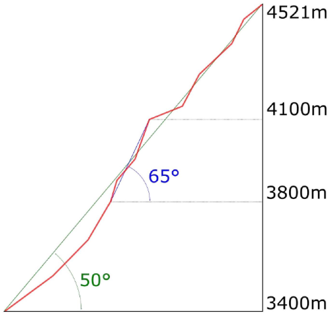
| 3.8 | Average Steepness of the Route, (°) | 50° |
| 3.9 | Average Steepness of the Main Part of the Route, (°) | 65° |
| 3.10 | Descent from the Summit | Via 5B cat. complexity to Kara-Suu valley |
| 3.11 | Additional Characteristics of the Route | Water is present at R19 |
| 4. Characteristics of Team Actions | ||
| 4.1 | Time of Movement (team's walking hours, in hours and days) | 20.5 hours, 3 days |
| 4.2 | Overnights | On platforms (R11, R19) |
| 4.3 | Time Spent on Route Development | 0 hours, 0 days |
| 4.4 | Start of the Route | 7:00 July 31, 2021 |
| 4.5 | Summit Ascent | 12:00 August 2, 2021 |
| 4.6 | Return to Base Camp | 15:00 August 3, 2021 |
| 5. Characteristics of Weather Conditions | ||
| 5.1 | Temperature, °C | –2–25 °C |
| 5.2 | Wind Speed, m/s | 0–6 m/s |
| 5.3 | Precipitation | 20 mm |
| 5.4 | Visibility, m | 35000 m |
| 6. Person Responsible for the Report | ||
| 6.1 | Full Name, e-mail | Panov Andrey Olegovich, aopanov@gmail.com |
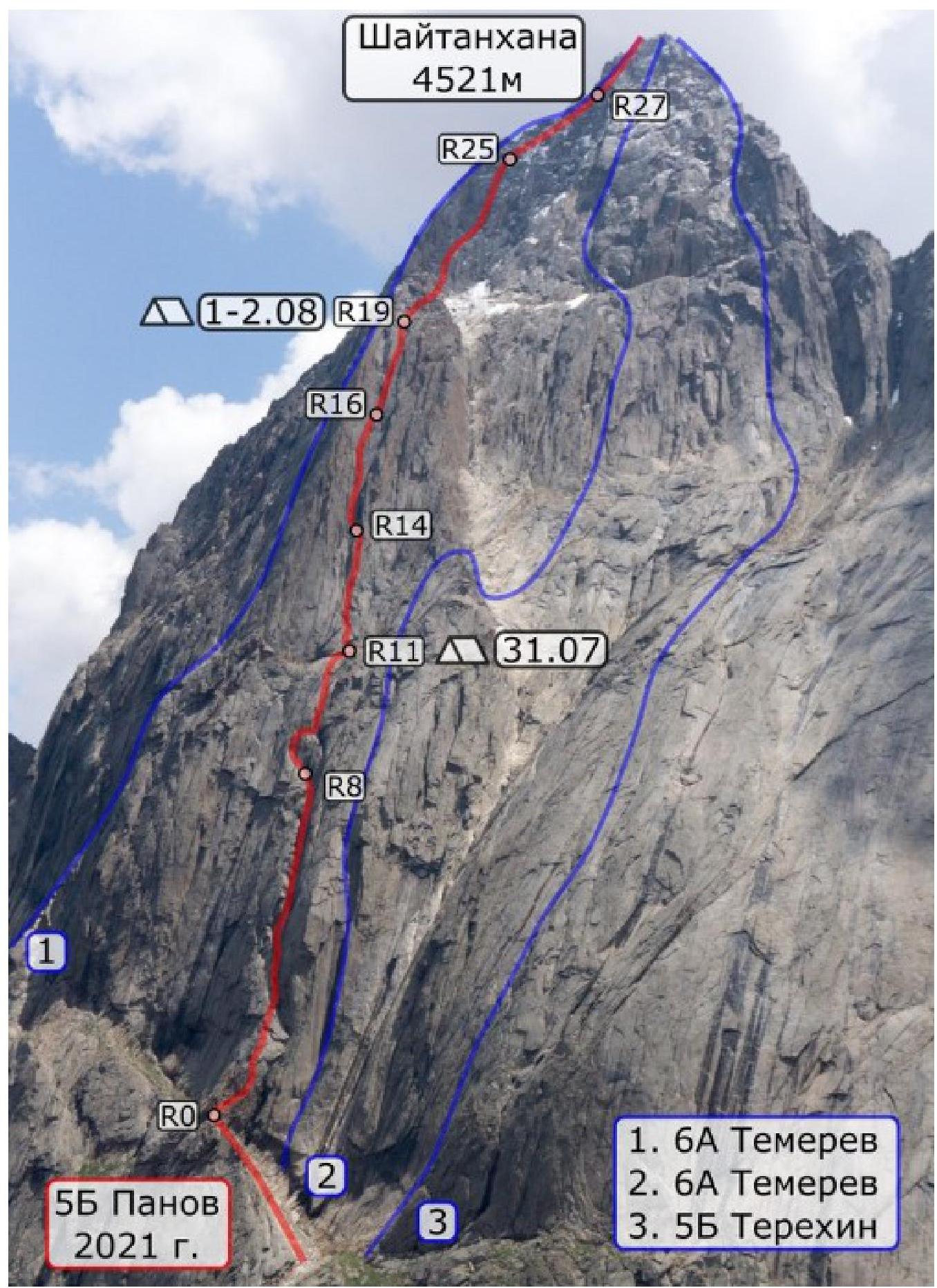
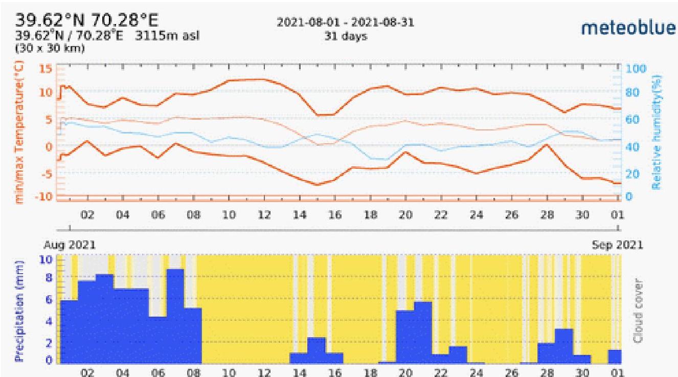
General Route Photo Date of Photo: July 20, 2021 Location of Photo: N39.6258 E70.2562
Route Profile Photo
Drawn Route Profile
Climbing Description
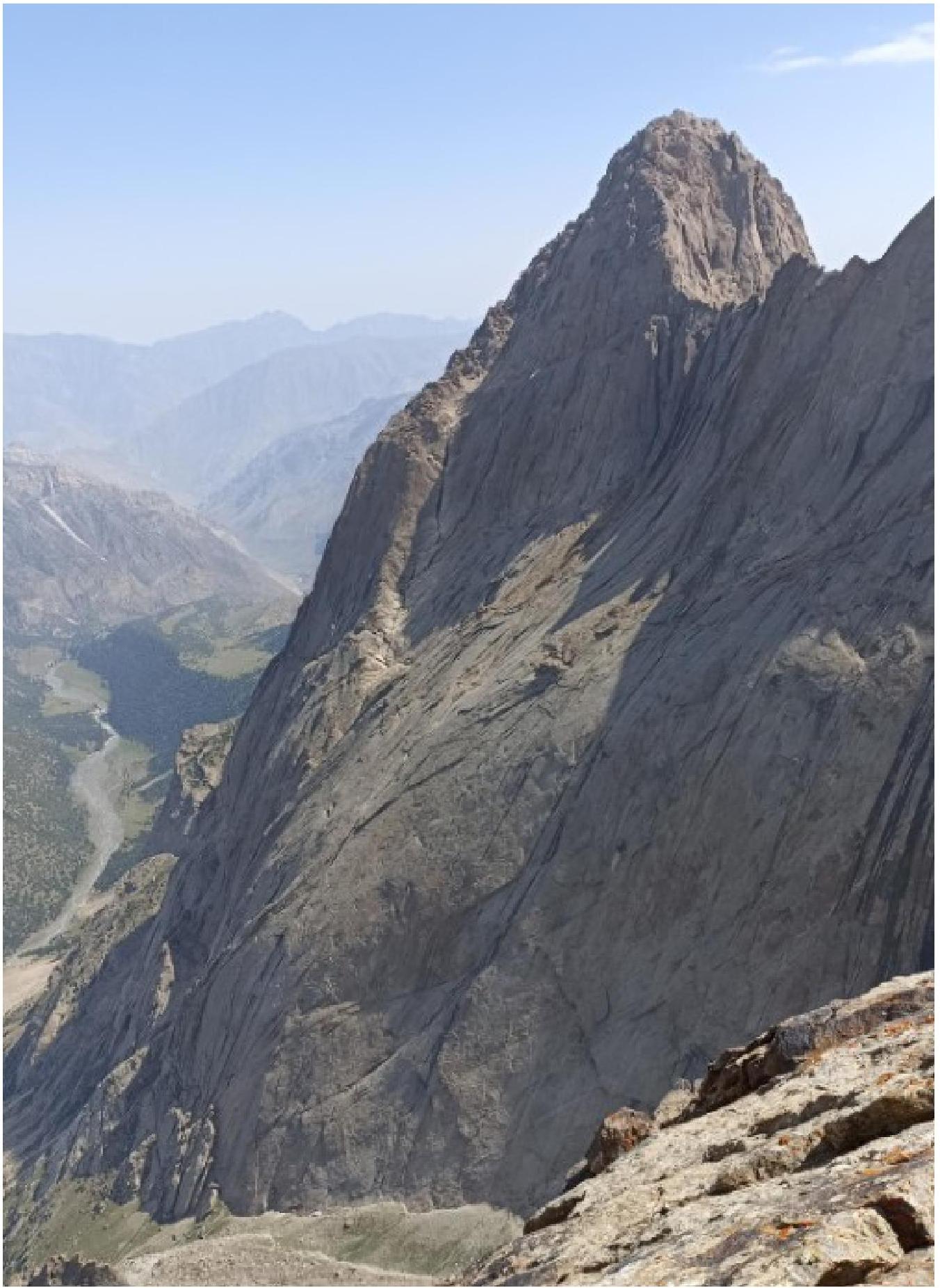
ShaitanKhana Peak, also known as Kotin Peak (4521 m), is located in close proximity to the standard base camp location in the Kara-Suu valley. The first ascents to the summit date back to 1988, at the beginning of the Karavshin area exploration.
Currently, there are three routes to ShaitanKhana via the western wall recorded in the FAR database:
- Temerev 6A via the central keystone of the NW wall, 2018
- Temerev 6A via the inner corner of the W wall and the center of the upper bastion, 2019
- Terekhin 5B via the right part of the W wall, 2019
Our route passes midway between routes 1 and 2. The route can be conditionally divided into three parts:
"First Bastion": in the first part, the route follows a huge inner corner, mainly along its left side, where it's wet. The terrain is relatively simple but slippery in places, making it challenging to organize belays.
The first bastion ends at a large shelf-terrace. Directly at the exit from the route onto the shelf lies a huge boulder leaning against the wall, under which a bivouac can be set up. There's also a ledge for a tent on the right side of the terrace (100 m from the route).
The second bastion is significantly steeper than the first, with the route proceeding via a system of inner corners and cracks. There are small ledges for overnight stays.
The second bastion ends at a huge shelf-shoulder; there's a good spot for a tent, and a stream runs at the base of the third bastion.
The third bastion is ascended on its left side. The terrain is fragile, with sections of moderate climbing complexity. After reaching the northern summit ridge, the route crosses a snow couloir and a large snowfield, requiring crampons.
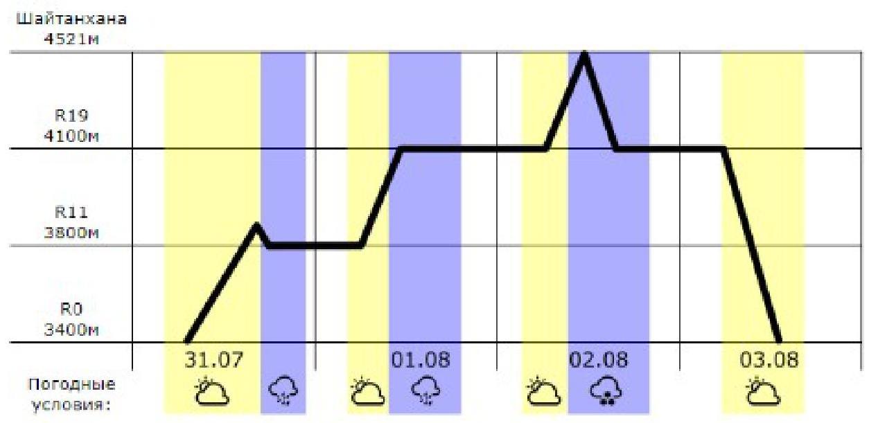
Weather Conditions and Climbing Schedule
Area Map
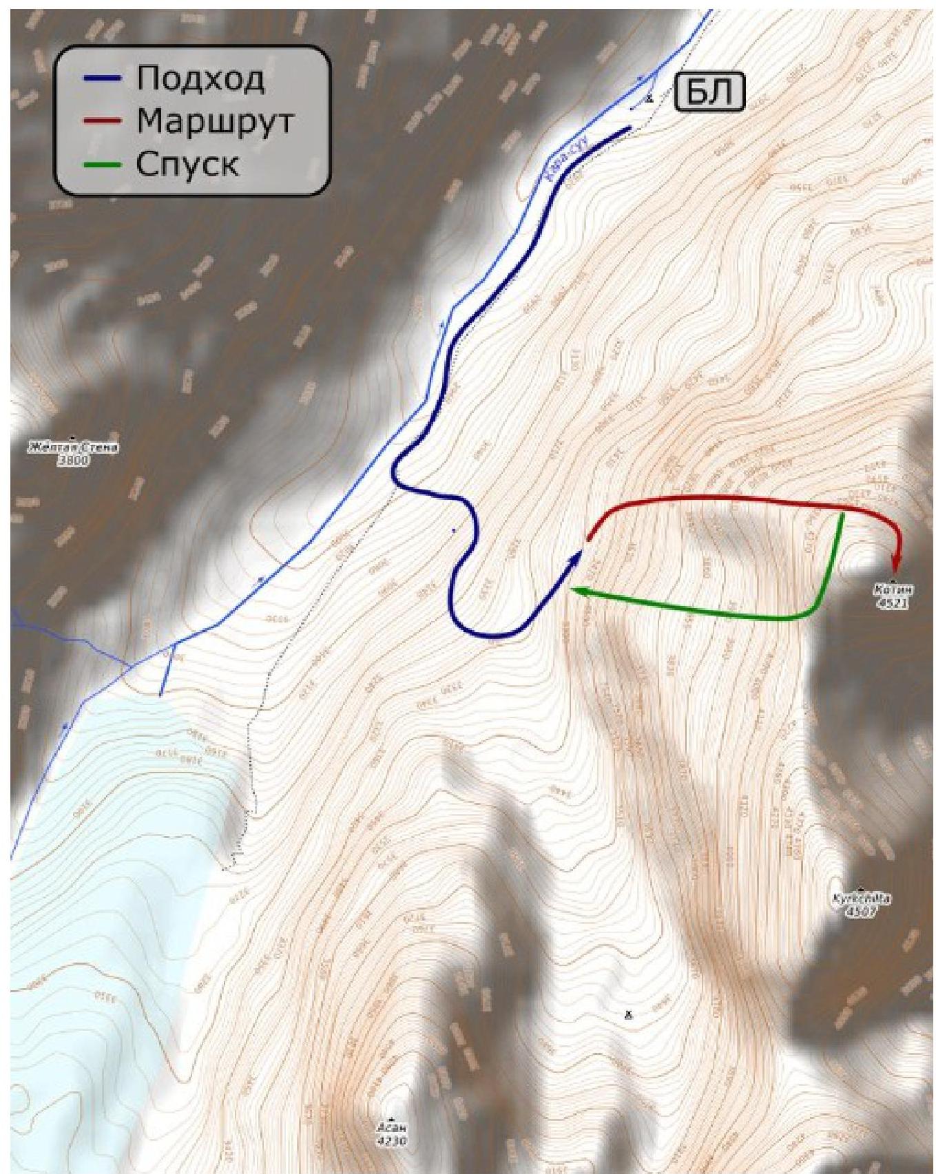
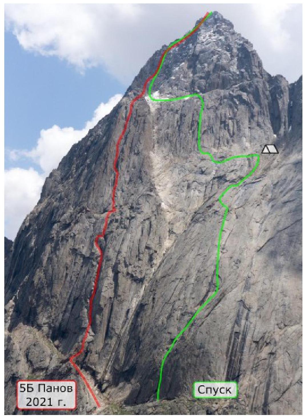
Approach: From the camp (N39.6357 E70.2686) in the Kara-Suu river valley, follow the trail towards Asan for 1.5 km, then turn left and ascend 500 m along a steep trail to the base of the western wall of ShaitanKhana Peak. From here (N39.6229 E70.2624), leave the trail and move left towards the start of the route, crossing two small couloirs, and then ascend along a talus shelf to the base of the red "finger," R0 (N39.6253 E70.2666).
R0–R1 (45 m IV): Ascend 5 m upwards and then traverse right along a sloping shelf to its end.
R1–R2 (45 m 5c): Move right around the corner for 5 m and then ascend via the inner corner, reaching a col between the red "finger" and the wall.
R2–R4 (100 m IV): Proceed via "ram's foreheads" to the base of the huge inner corner.
R4–R5 (50 m: 20 III, 10 IV, 20 III): Move along the inner corner, adhering to the left wall, as the corner is wet.
R5–R6 (50 m: 10 V, 40 IV): Approach a small inner corner, ascend 10 m up the right wall, then traverse left along a shelf back into the main corner.
R6–R7 (50 m: 30 IV, 20 V): Continue along the left side of the corner for 30 m, traverse left for 5 m, and ascend 15 m up the left corner.
R7–R8 (50 m: 35 IV, 15 V): Continue up the corner; after 20 m, traverse left for 15 m, and after 5 m, exit into the base of R8.
R8–R9 (50 m: 10 IV, 30 VI, 10 IV): Traverse left into the corner for 5 m, ascend 15 m, return to the right corner, and ascend 20 m up it, reaching a shoulder.
R9–R10 (50 m: 20 IV, 30 V): Ascend via the corner to a finger-like ledge, then ascend along gentle slabs.
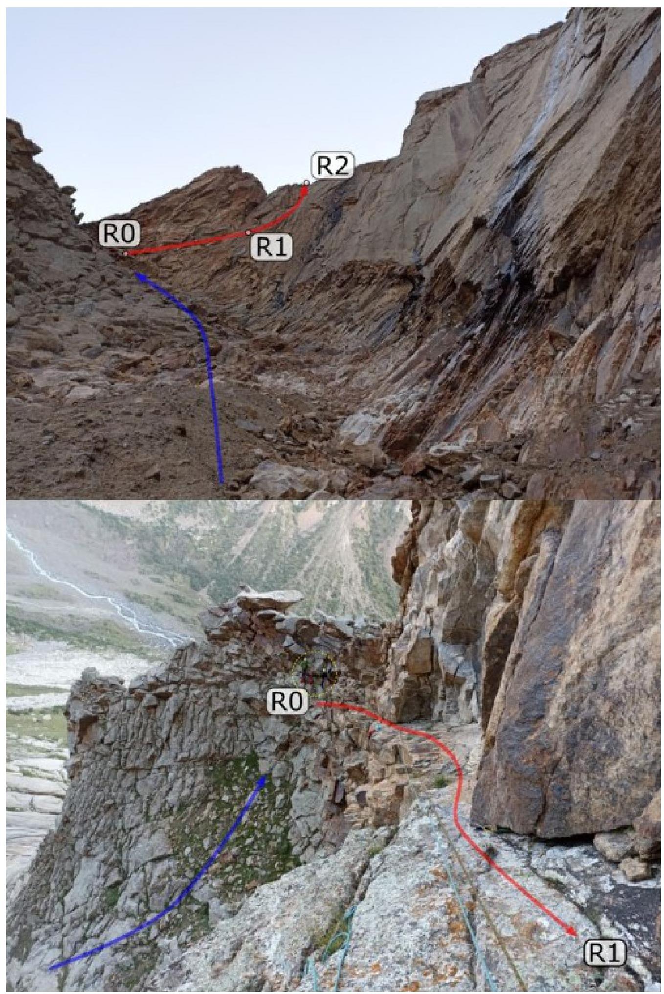
R10–R11 (50 m: 20 III, 30 V+): Exit 10 m onto a shelf-terrace via slabs. Climb onto a huge leaning boulder on the right, and then ascend 30 m up the corner.
Under the boulder, there's a possible overnight stay (2–3 people), and if one traverses right along the ledge for 70 m, there's a platform for a tent (2–3 people).
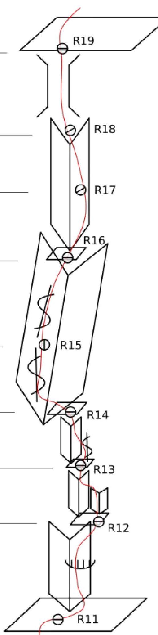
R11–R12 (40 m 6b): Ascend via the right corner, through overhangs, to a shelf (possible semi-sitting overnight stay).
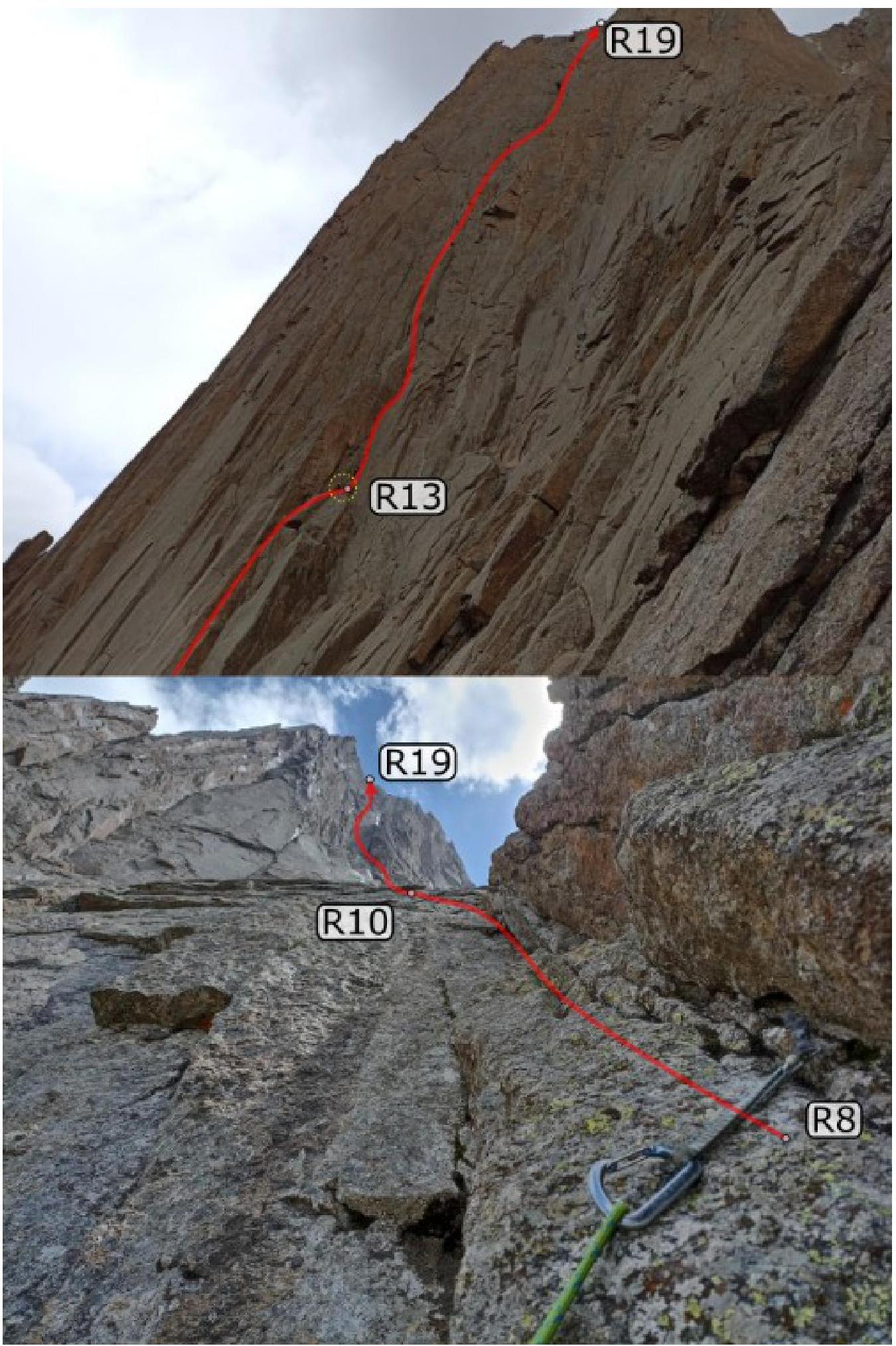
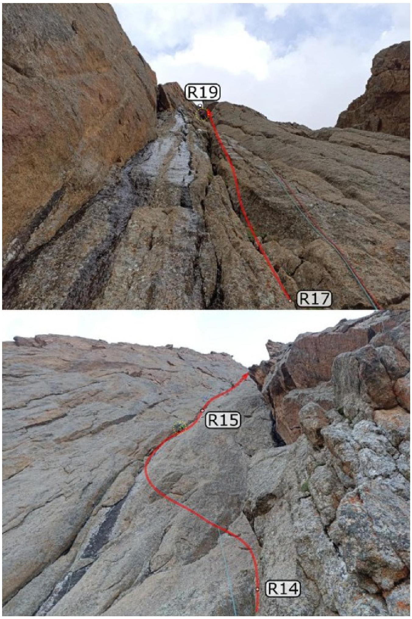
R12–R13 (40 m: 15 6b, 25 V): From the shelf, move upwards via the right inner corner, exit into a niche, return to the left corner, and continue up the corner to a shelf.
R13–R14 (40 m V–6a): From the shelf, ascend via a crack and then along an inner corner to a shelf, traverse left 2 m around the corner of a large counterfort.
R14–R15 (50 m 6c): Ascend via the left wall of a huge, destroyed inner corner-chimney.
R15–R16 (70 m IV–V): Continue up the left wall of the chimney, through "feathers," to a shelf at the base of the corner.
R16–R17 (50 m: 30 6a, 20 V): Ascend via the right side of the inner corner.
R17–R18 (50 m: 20 6b, 30 V): Continue up the inner corner.
R18–R19 (50 m: 20 V+, 20 IV): Exit into a crack-chimney; ascend via it until it flattens.
At the exit, there's a good spot for a tent; water can be fetched further along, 200 m away, at the base of the third bastion.
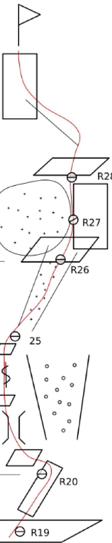
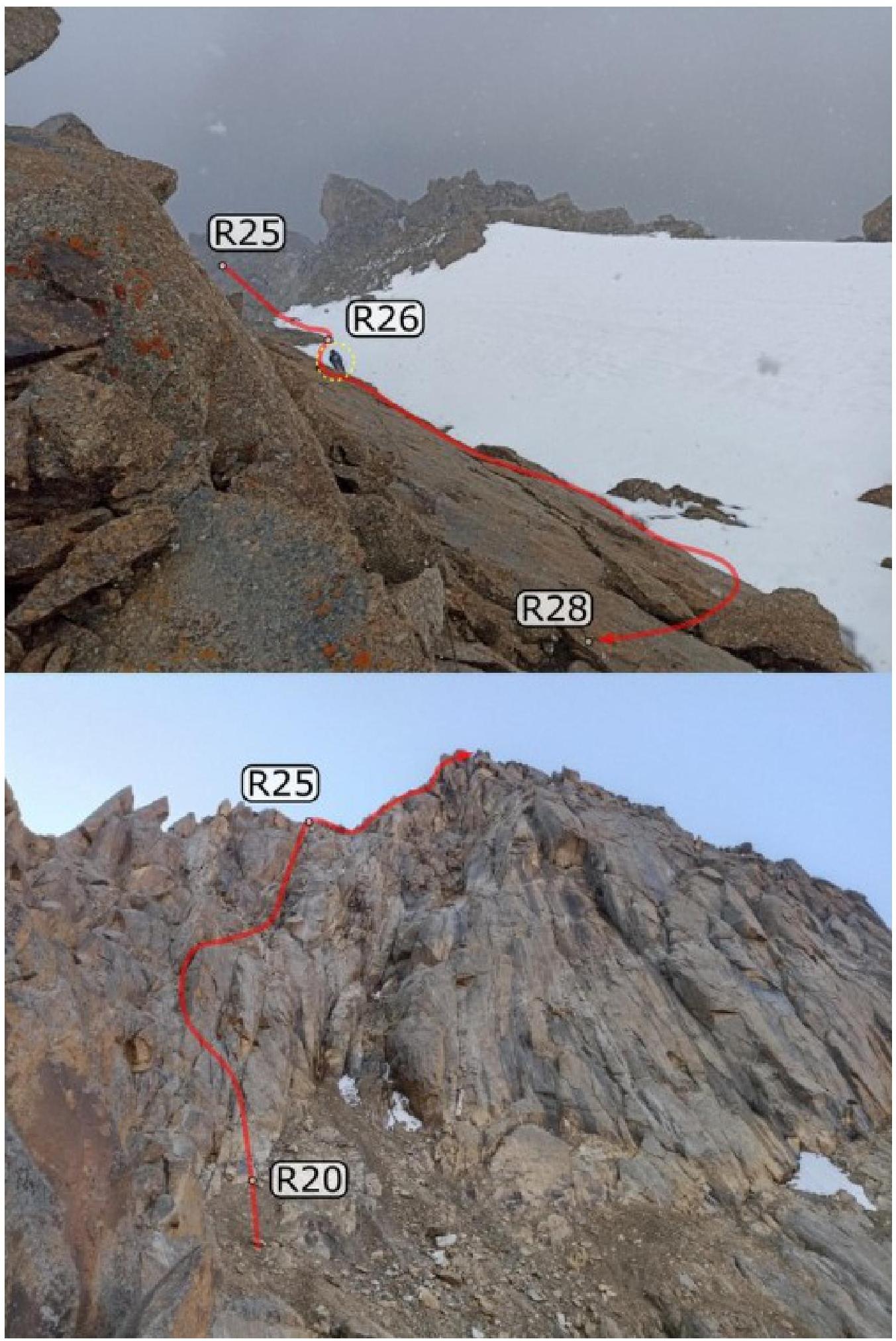
R19–R20 (200 m II): Traverse along a destroyed shelf-terrace to the base of the third bastion.
R20–R25 (300 m: 250 II–IV, 50 V): Ascend via the left part of the couloir, exiting onto a shelf at the base of the northwest summit ridge. Most is straightforward, with sections of 10–15 m at 5th category difficulty.
Crampons are necessary for sections R25–R28.
R25–R26 (70 m V): From the shelf, ascend via a narrow snow couloir to the base of a large snowfield.
R26–R28 (100 m IV–V): Ascend via the right boundary of snow and rocks to the gentle part of the northern summit ridge.
R28–Summit (100 m III–IV): Proceed 100 m along the ridge to the summit.
Route Diagram in UIAA Symbols (no ITO used)
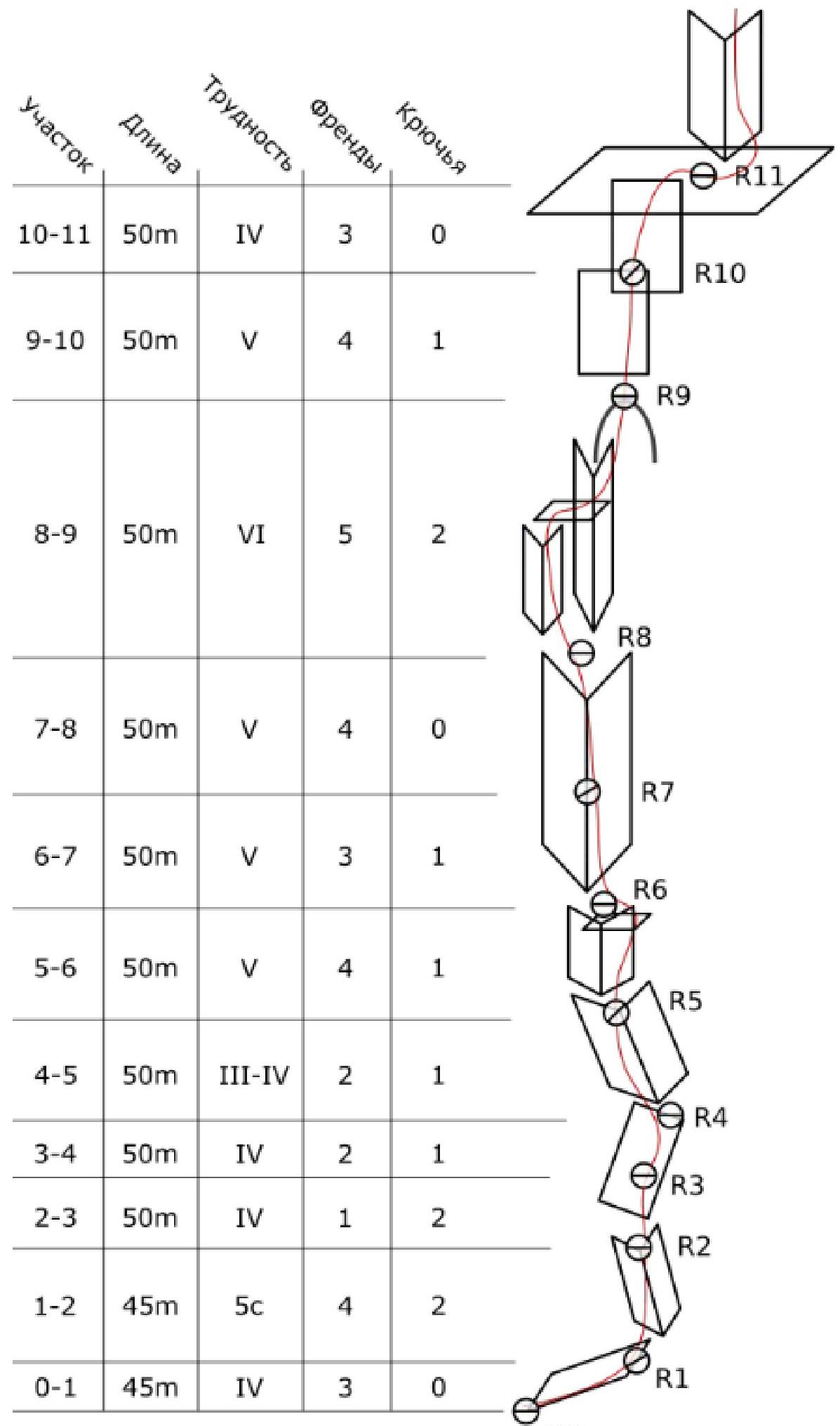
| Section | Length | Difficulty | Friends | Pitons |
|---|---|---|---|---|
| R10–R11 | 50 m | IV | 3 | 0 |
| R9–R10 | 50 m | V | 4 | 1 |
| R8–R9 | 50 m | VI | 5 | 2 |
| R7–R8 | 50 m | V | 4 | 0 |
| R6–R7 | 50 m | V | 3 | 1 |
| R5–R6 | 50 m | V | 4 | 1 |
| R4–R5 | 50 m | III–IV | 2 | 1 |
| R3–R4 | 50 m | IV | 2 | 1 |
| R2–R3 | 50 m | IV | 1 | 2 |
| R1–R2 | 45 m | 5c | 4 | 2 |
| R0–R1 | 45 m | IV | 3 | 0 |
| Section | Length | Difficulty | Friends | Pitons |
|---|---|---|---|---|
| R18–R19 | 50 m | IV–V+ | 3 | 1 |
| R17–R18 | 50 m | V–6a | 4 | 1 |
| R16–R17 | 50 m | V–6a | 4 | 2 |
| R15–R16 | 70 m | IV–V | 4 | 1 |
| R14–R15 | 50 m | 6c | 6 | 3 |
| R13–R14 | 40 m | 6a | 4 | 3 |
| R12–R13 | 40 m | 6b | 5 | 3 |
| R11–R12 | 40 m | 6b | 6 | 2 |
| Section | Length | Difficulty | Friends | Pitons |
|---|---|---|---|---|
| R28–R29 | 100 m | III–IV | 2 | 0 |
| R27–R28 | 50 m | V | 4 | 0 |
| R26–R27 | 50 m | V | 3 | 1 |
| R25–R26 | 70 m | V | 1 | 3 |
| R20–R25 | 300 m | III–V | 10 | 2 |
| R19–R20 | 200 m | II | 0 | 0 |
Team Actions
By the start of the ascent, the valley was experiencing poor weather. According to the forecast (obtained via satellite phone), the following days were also expected to have precipitation.
On July 30, 2021, an attempt was made to start the ascent, but the route was not begun due to rain starting early in the morning. Nevertheless, the approach path under the route was reconnoitered, and all equipment, food, and water were cached at R0.
On July 31, 2021, at 5:00, the team left Base Camp and approached the route by 7:00. The weather was overcast but without precipitation. The inner corner of the first bastion, through which the route passes, was filled with water, making it necessary to climb very carefully. By 13:00, they ascended to the R11 ledge. The pair Kovalenko-Pilshchikova continued to hang ropes to R14, while the rest of the team remained at R11 to set up a bivouac. At 15:00, rain began, and by 16:00, the entire team had gathered at R11.
On August 1, 2021, they started at 6:00. The second bastion was noticeably steeper than the first, with challenging climbing. Many "blind" cracks were filled with damp moss. By 13:00, they had ascended through the second bastion; rain with snow began, and they decided to leave the summit for the next day.
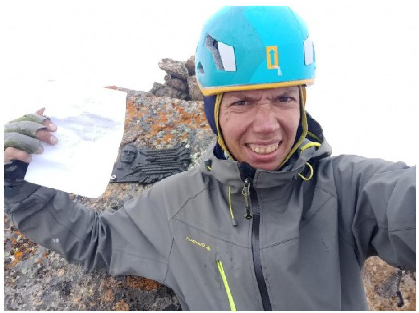
On August 2, 2021, they departed at 7:30. The weather was overcast; by 11:00, a cloud had settled on the summit, and snow began. A distant thunderstorm was observed. To expedite the descent, one person was sent to the summit, while the rest of the team prepared rappel anchors from R28. A note from Temerev I. (dated August 5, 2019) was found on the summit. At 12:00, they began their descent, reaching the tent on R19 by 15:00.
On August 3, 2021, the weather was good in the morning. At 6:30, they began their descent via rappel loops, returning to Base Camp in the Kara-Suu river valley by 15:00.
Descent
From the summit, return along the northern ridge to the upper part of the snowfield. From here, rappel twice to the base of the snow couloir. Continue descending along the ascent route. Much of it is walked, but some sections require rappelling.
Descend to the ledge at the base of the summit bastion (R20) and traverse 150 m along it towards Kyrkchilta Peak. On the left wall, there's a rappel station (white loop on two placements, carabiner). From here, rappel four times for 50–60 m. Traverse further left along a narrow ledge for another 150–200 m. At the end of the ledge, there's a spot for a tent. Just beyond the overnight stay, a wide, destroyed couloir begins; descend 150–200 m down it (II–III) to a large boulder tied with a white rope. After another 20 m beyond the boulder, on a small shoulder, there's a rappel loop. Continue rappelling down from here, with some sections being up to 70 m.
List of Descent Sections:
- From the summit to the ledge at the base of the bastion (R20) — descent and traverse 150 m.
- 4 rappels of 50–60 m from the left wall.
- Traverse along a narrow ledge — 150–200 m.
- Descent down the couloir (II–III) — 150–200 m to the boulder.
- From the boulder to the rappel loop — 20 m.
- Rappels from the loop to the ground — about 15 rappels, including sections up to 70 m.

3.3. Safety Assessment of the Route. Recommendations for Subsequent Climbers.
We consider the route we traversed to be logical and safe, with a preliminary category of complexity of 5B. The route is in close proximity to the Kara-Suu base camp, facilitating radio communication and team observation. Crampons may be necessary in the upper part of the route. Compared to other 5B routes in the area, such as the Gorbenko 5B route on Asan, our route is comparable in complexity but exceeds it in length.
Equipment Recommendations:
- A set of sling "hardware"
- Anchor pitons
- Rock shoes
- Crampons
For the descent, two 60 m ropes will be needed. The descent from the summit proceeds along the western wall (practically along Terekhin's 5B route).