- Class of technical ascents.
- Pamir-Alai, Turkestan Range, Karavshin (Kara-su) valley
- The summit of peak 4810 via the "mirror" of the western wall (Rusyayev's route).
- Category of difficulty — 6B.
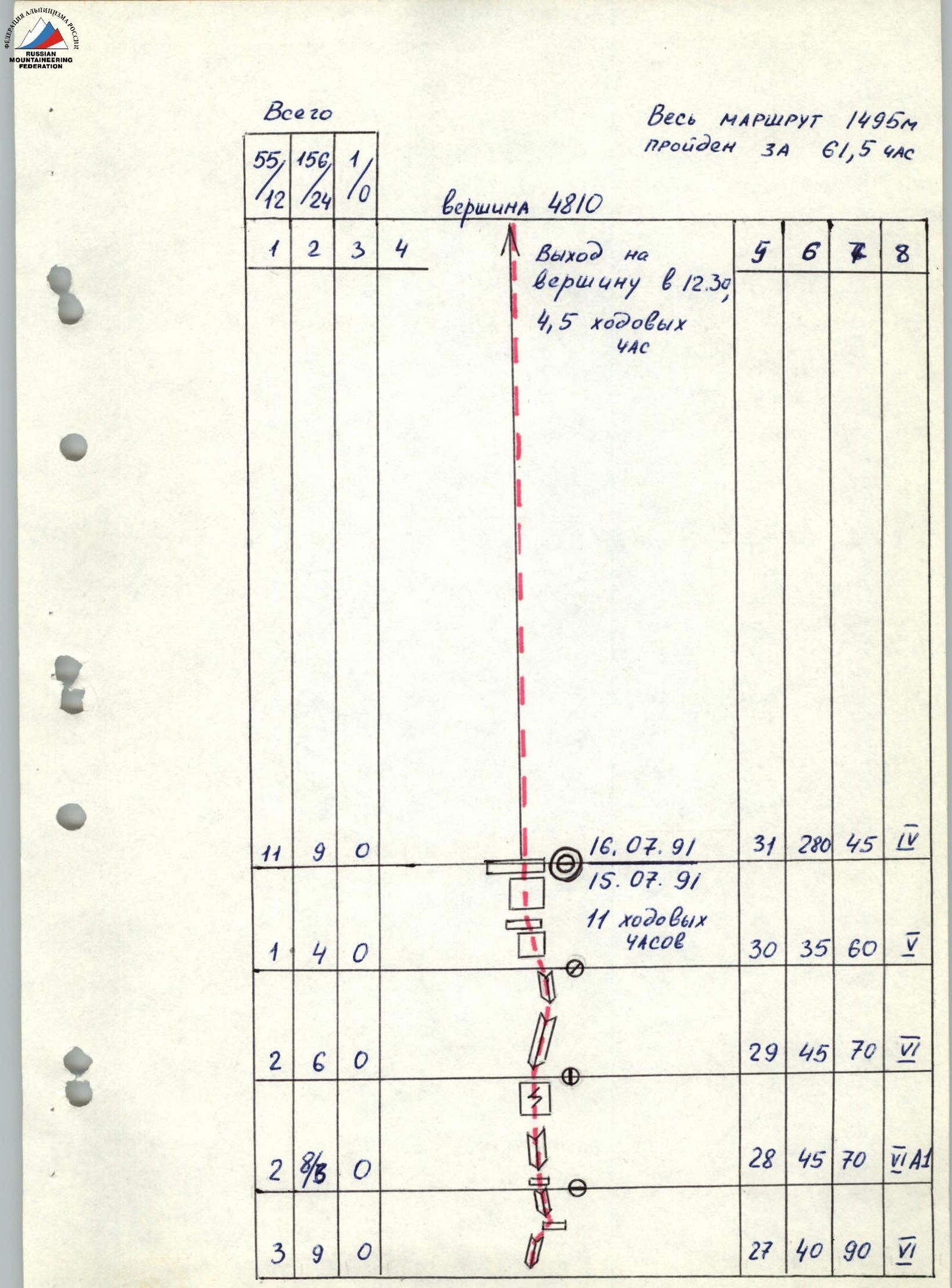
- Height difference 1160 m, route length 1495 m, length of sections 5–6 c.t. 1220 m, average steepness 68°, average steepness of the wall part of the route 74°.
- Pitons driven:
| Rock | Chocks | Bolt pitons |
|---|---|---|
| 55 / 12 | 156 / 24 | 1 / 0 |
- Team's working hours — 61.5 hours, days — 5.5 days.
- Overnight stays — 4 bivouac nights on snow ledges.
- Weather conditions — complex, 2-day wait on the second bivouac.
- Captain: Vinokurov Anatoly Filippovich — Master of Sports
Team members:
- Komarov Viktor Vasilyevich — Candidate for Master of Sports
- Sakharov Konstantin Alekseyevich — Candidate for Master of Sports
- Telpov Alexander Alekseyevich — Candidate for Master of Sports
- Shcherbakov Alexander Nikolayevich — Candidate for Master of Sports
- Zuyeva Tamara Alexandrovna — Candidate for Master of Sports
-
Coach: Vinokurov Anatoly Filippovich — Master of Sports
-
Route reconnaissance on July 9, 1991. Departure on the route on July 10, 1991.
- Waiting on the 2nd bivouac on July 12 and 13, 1991.
- Summit on July 16, 1991.
- Return to camp on July 16, 1991.
- Organization — Moscow Regional Sports Committee.

Photo 1. General photo of the summit. Taken on July 6, 1991 at 16:00 from point 1, distance to the wall 5000 m, height 3500 m, with a "Jupiter-37" lens, F = mm. Routes:
- Kritsuk
- Rusyayev
- Voronov
- Kopeyka
Photo 2. Profile of the wall on the right. Taken on July 9, 1991 at 10:00 from point F2, distance to the wall 1000 m, height 3900 m, with a "Helios-44M4" lens, F = 58 mm.

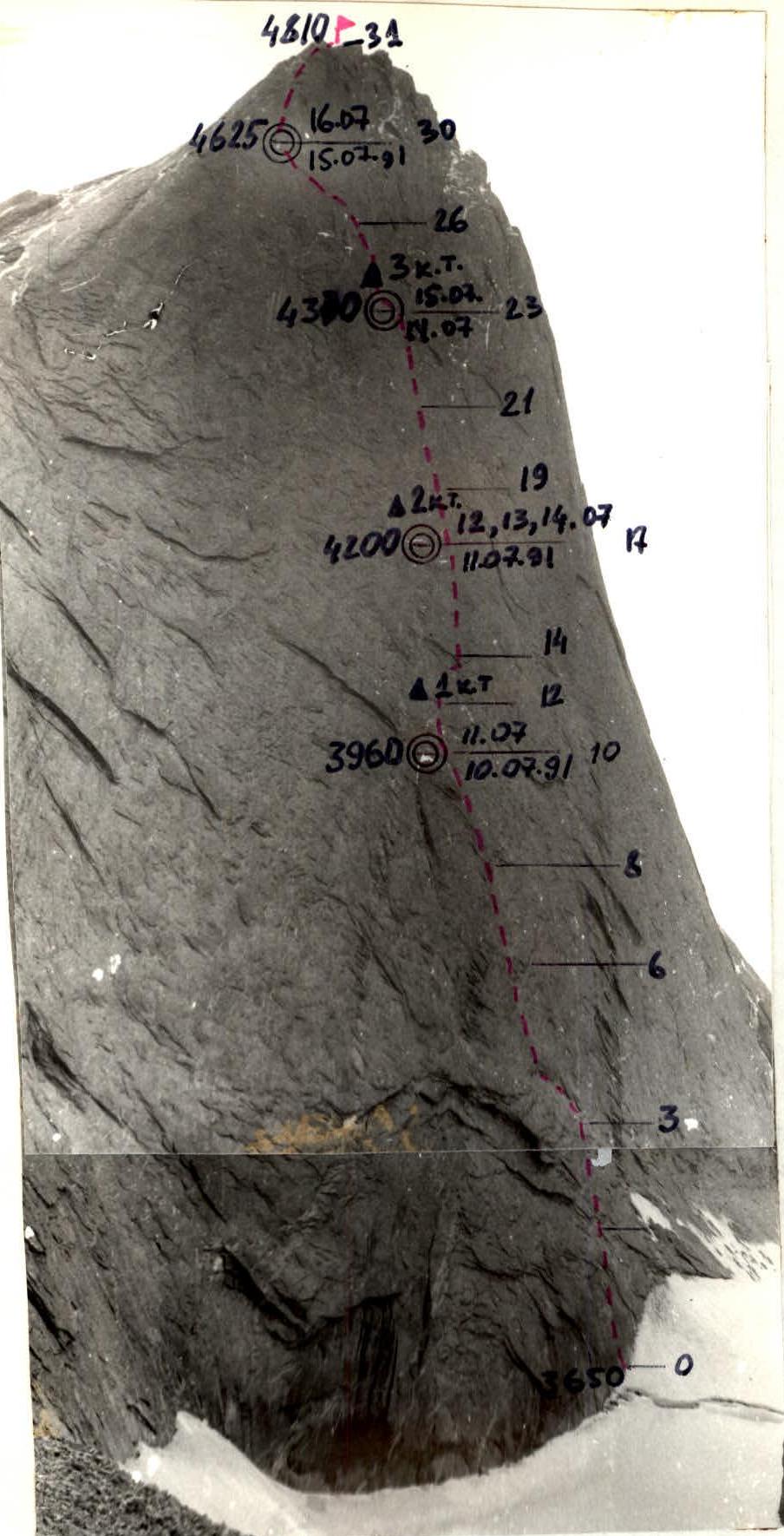
Photo 3. Profile of the wall on the left. Taken on July 9, 1991 at 12:00 from point F3, distance to the wall 1000 m, height 3600 m, with a "Helios-44M4" lens, F = 58 mm.
Tactical actions of the team.
The team fully implemented the tactical plan developed before the ascent, taking into account two days of waiting on the second bivouac due to bad weather.
The tactical plan included the order of work for the rope teams and linking the movement schedule to control points. Some adjustments were made during the ascent. For example, on the day of route reconnaissance, only 3.5 ropes were processed (instead of 6 as planned) due to bad weather, and on the second day, the second rope team worked on more ropes.
The team worked on the route in the following order:
- July 9 — Komarov–Sakharov worked first
- July 10 — Shcherbakov–Telpov rope team
- July 11 — Komarov–Sakharov rope team
July 12 and 13 were spent waiting on the 2nd bivouac and coping with bad weather.
- July 14 — Shcherbakov–Telpov rope team worked first
- July 15 — Komarov–Sakharov rope team
- July 16 — Vinokurov–Zuyeva rope team.
This ensured rest for the participants and maintained the pace of movement.
The ascent utilized the entire arsenal of modern technical means:
- rock pitons
- chocks
- "friends"
- "sky hooks"
- крюконоги.
The first climber ascended on a double rope, subsequent ones — on fixed ropes with top rope belay.
Nutrition during the ascent was two meals a day, with additional individual nutrition during movement.
Communication with observers under the wall was carried out using a "Vitalka" radio station. The group was monitored using a 12x binocular.
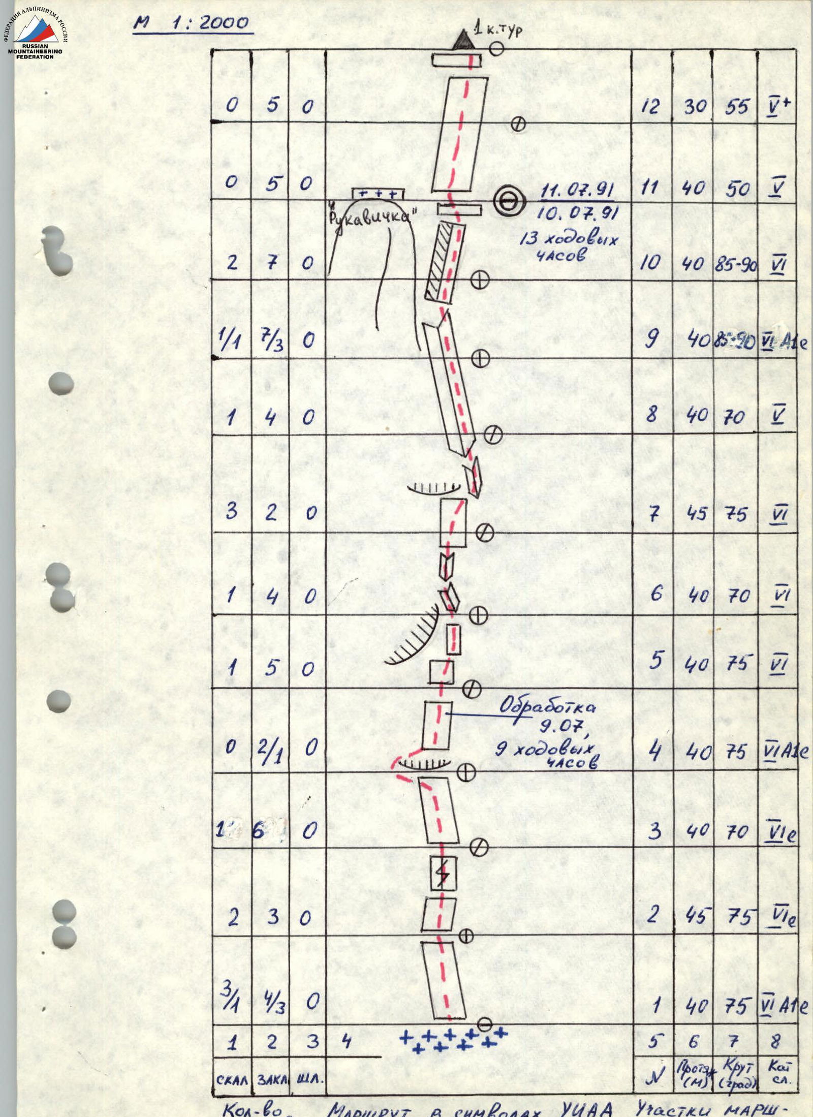
| Rock | Chocks | Bolt pitons | № | Length (m) | Steepness (°) | Category of difficulty | |
|---|---|---|---|---|---|---|---|
| 3/1 | 4/3 | 0 | R1 | 40 | 75 | 6 | |
| 2 | 3 | 0 | R2 | 45 | 75 | 6 | |
| 1 | 6 | 0 | R3 | 40 | 70 | 6 | |
| 0 | 2/1 | 0 | R4 | 40 | 75 | 6 | |
| 1 | 5 | 0 | R5 | 40 | 75 | 6 | |
| 1 | 4 | 0 | R6 | 40 | 70 | 6 | |
| 3 | 2 | 0 | R7 | 45 | 75 | 6 | |
| 1 | 4 | 0 | R8 | 40 | 70 | 6 | |
| 1/1 | 7/3 | 0 | R9 | 40 | 85–90 | 6 | |
| 2 | 7 | 0 | R10 | 40 | 85–90 | 6 | |
| 0 | 5 | 0 | R11 | 40 | 50 | 5 | |
| 0 | 5 | 0 | R12 | 30 | 55 | 5 | |
| 2 | 5 | 0 | R13 | 40 | 75 | 5 | |
| 3/2 | 8/2 | 0 | R14 | 45 | 90 | 6 | |
| 1 | 7 | 0 | R15 | 40 | 80 | 6 | |
| 3/1 | 6/2 | 1 | R16 | 40 | 90 | 6 | |
| 2 | 8 | 0 | R17 | 45 | 75 | 5 | |
| 1 | 5 | 0 | R18 | 40 | 85 | 6 | |
| 2 | 6 | 0 | R19 | 40 | 85 | 6 | |
| 1 | 6 | 0 | R20 | 40 | 80 | 6 | |
| 2 | 4 | 0 | R21 | 40 | 80 | 6 | |
| 3/2 | 7/2 | 0 | R22 | 40 | 85 | 6 | |
| 1 | 4 | 0 | R23 | 30 | 80 | 6 | |
| 2 | 5 | 0 | R24 | 40 | 80 | 6 | |
| 2 | 6 | 0 | R25 | 40 | 75 | 5 | |
| 2 | 4 | 0 | R26 | 40 | 75 | 5 | |
| 3 | 9 | 0 | R27 | 40 | 90 | 6 | |
| 2 | 8/6 | 0 | R28 | 45 | 70 | 6 | |
| 2 | 6 | 0 | R29 | 45 | 70 | 6 | |
| 1 | 4 | 0 | R30 | 35 | 60 | 5 | |
| 1 | 9 | 0 | R31 | 280 | 45 | 4 |
Description of the route by sections.
R1–R3 — monolithic slab with minimal footholds. Belay points on bolt pitons. Climbing is difficult.
R4 — cornice. Overcome on the left side. Further up the monolithic slab with minimal footholds. Climbing is difficult. "Sky hooks" and bolt pitons are used for belay organization.
R5 — overhang. Bypass in the direction of large cracks and an oblique angle.
R6–R7 — large cracks. Entering a large oblique angle via the cracks.
R8–R9 — oblique angle. Movement along the oblique angle towards the overhanging angle.
R10 — overhanging angle. Movement up the angle. Climbing is difficult with the use of artificial aids. A small ledge, to the left — a bivouac on the "Glove".
R11, R12 — the wall becomes less steep. Rocks are smoothed by water flows. Exit to a ledge. 1st control point.
R13 — steepness increases. Monolithic wall with few footholds. Movement first up, then to the right of a large cornice.
R14 — large cornice. Bypassed on the right via large cracks, slabs that are lagging behind the wall. Quite reliable. Entry into a steep angle. Climbing is difficult.
R15 — movement along the angle under the cornice. Climbing is difficult.
R16 — under the cornice, traverse to the right using "sky hooks" and artificial aids. Entry into the angle. Further up the angle to a ledge. Climbing is difficult.
R17 — exit to a ledge via angles. 2nd control point. Good bivouac.
R18, R19 — monolithic wall with sufficient footholds. Movement towards a large, clearly defined angle.
R20 — up a small internal angle to a clearly defined angle. Swing to the right. Entry into the clearly defined angle. Climbing is difficult.
R21 — up the angle to a small ledge.
R22, R23 — from the ledge, up the right angle under the cornice. Under the cornice, a bolt piton. Swing to the left. Entry into an internal angle leading to a ledge. Climbing is difficult. 3rd control point. Good bivouac.
R24, R25 — movement along the monolithic wall towards an overhanging angle with few footholds. Further up the overhanging angle.
- Up the overhanging angle with a clear objective upwards. Artificial aids. Climbing is difficult. Exit to a ledge.
- Series of internal angles. Iced. Artificial aids. Lead to a small ledge.
- Internal angle leads to a wall. Iced. Artificial aids.
- Series of internal angles. Snow. Exit to a wall.
- Series of walls with exit to a ridge. Good place for a bivouac.
- Ridge is not clearly defined. There are walls and slabs of varying steepness.
Descent from the summit along the ridge towards the Lomonosov peak to the col between 4810 and Lomonosov and further into the Ak-su valley.
Equipment table.
| 1. | Main rope | — 7 pcs. x 45 m |
| 2. | Titanium carabiners | — 70 pcs. |
| 3. | Chocks | — 30 pcs. |
| 4. | Titanium rock pitons | — 25 pcs. |
| 5. | Extender loops | — 15 pcs. |
| 6. | Rock hammers | — 3 pcs. |
| 7. | Ring ladders | — 3 pairs |
| 8. | Kookonogi | — 3 pairs |
| 9. | Friends | — 5 pcs. |
| 10. | Bolt pitons | — 10 pcs. |
| 11. | Punchers | — 3 pcs. |
| 12. | Sky hooks | — 4 pcs. |
| 13. | First aid kit | — 2 sets |
| 14. | Helmet | — 6 pcs. |
| 15. | Harnesses | — 6 pcs. |
| 16. | Self-belay devices | — 6 pcs. |
| 17. | Climbing jammers | — 12 pcs. |
| 18. | Down jackets | — 6 pcs. |
| 19. | Vibram-type boots | — 4 pairs |
| 20. | Sneakers | — 2 pairs |
| 21. | Galoshes | — 2 pairs |
| 22. | Rock shoes | — 1 pair |
| 23. | Down sleeping bag | — 3 pcs. |
| 24. | Tent | — 2 pcs. |
| 25. | Stove | — 1 pc. |
| 26. | Gasoline | — 3 l |
| 27. | Pots | — 2 pcs. |
| 28. | Matches | — 6 boxes |
| 29. | Lantern | — 1 pc. |
| 30. | Water flasks | — 3 pcs. |
| 31. | "Vitalka" radio station | — 1 pc. |
| 32. | Food products | — 16 kg |

Photo 5. Technical photo of the summit. Taken on July 6, 1991 at 16:00 from point 1, distance to the wall 5000 m, height 3500 m, with a "Jupiter-37" lens, F = mm.