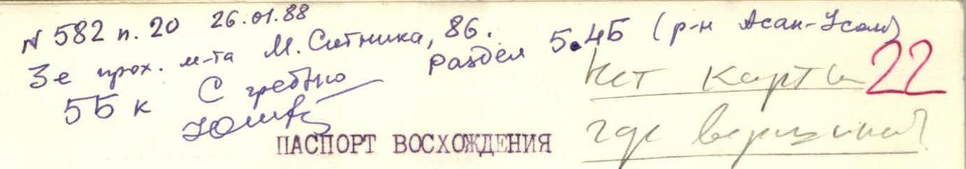
№ 582 p. 20 26.01.88
ASCENT DOCUMENT
I. Ascent class — technical. 2. Pamir-Alay, Turkestan Ridge. 3. Peak 4810 m from the northwest. 4. Third ascent, 5B category of complexity. 5. Route characteristics: elevation gain — 1550–1650 m, length of 5th category sections — 660 m, 6th category — 260 m, average steepness — 540 6. Pitons driven: - rock — 104 - bolt — 4 - ice — 35 - placements — 35 - "sky-hook" — 7 7. Time on the route — 33 hours (4 days) 8. Number of nights spent — 3 nights. - Lying — 1 - Semi-reclining — 1 - Sitting — 1 9. Participants: Voronov Alexander Anatolyevich — Candidate Master of Sports Bankovsky Mikhail Georgievich — Candidate Master of Sports 10. Coach: Solonnikov Viktor Alexandrovich — Master of Sports of International Class 11. Departure on the route July 1, 1987 Return July 4, 1987 12. Team of LOS DSO "Trud"
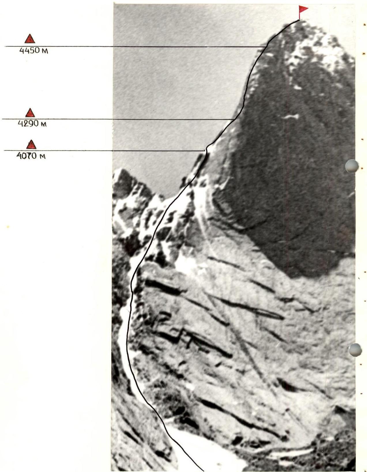
Route scheme in symbols
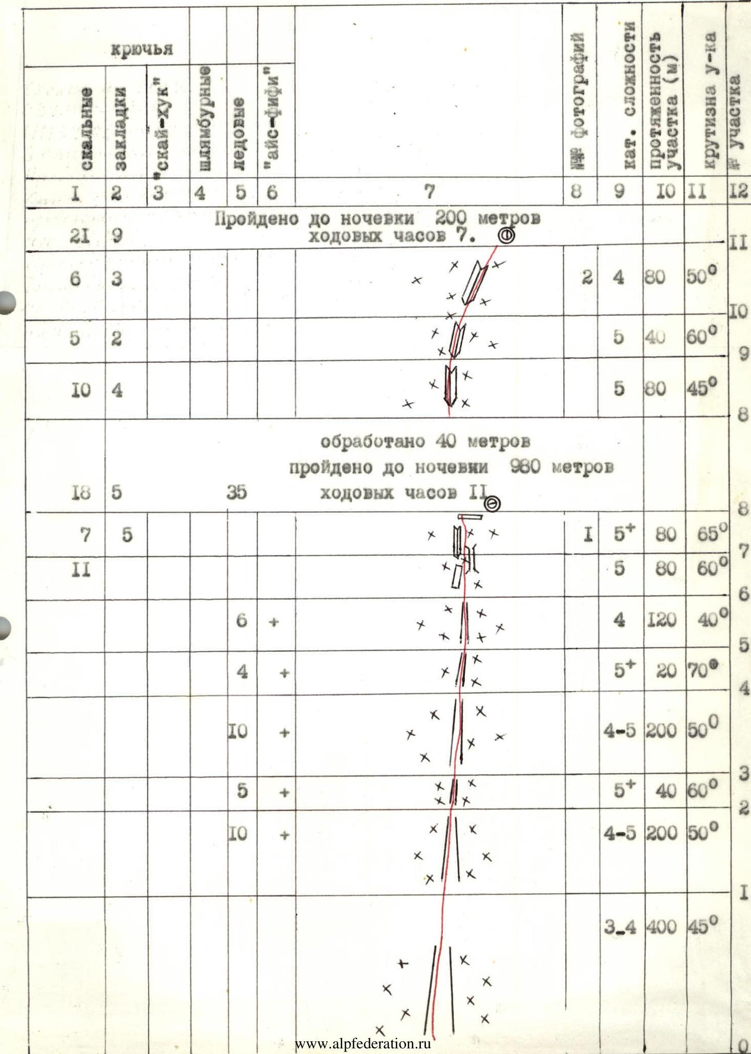
| № | Rock | Placements | "Sky-hook" | Bolt | Ice | "Ice-fifi" | Cat. diff. | Section length (m) | Steepness of section |
|---|---|---|---|---|---|---|---|---|---|
| R0–R1 | 3–4 | 400 | 45° | ||||||
| R1–R2 | 4–5 | 200 | 50° | ||||||
| R2–R3 | 5 | 40 | 60° | ||||||
| R3–R4 | 4–5 | 200 | 50° | ||||||
| R4–R5 | 5 | 20 | 70° | ||||||
| R5–R6 | 10 | 4 | 120 | 40° | |||||
| R6–R7 | 7 | 5 | 11 | 5 | 80 | 60° | |||
| R7–R8 | 18 | 5 | 35 | 5 | 80 | 65° |
40 meters processed. 980 meters covered before overnight stay. 11 hours of walking.
200 meters covered before overnight stay. 7 hours of walking.
| № | Rock | Placements | "Sky-hook" | Bolt | Ice | "Ice-fifi" | Cat. diff. | Section length (m) | Steepness of section |
|---|---|---|---|---|---|---|---|---|---|
| R8–R9 | 10 | 4 | 5 | 80 | 45° | ||||
| R9–R10 | 5 | 2 | 5 | 40 | 60° | ||||
| R10–R11 | 6 | 3 | 2 | 80 | 50° |
40 meters processed. 240 meters covered before overnight stay. 10 hours of walking.
| № | Rock | Placements | "Sky-hook" | Bolt | Ice | "Ice-fifi" | Cat. diff. | Section length (m) | Steepness of section |
|---|---|---|---|---|---|---|---|---|---|
| R11–R12 | 7 | 4 | 3 | 6 | 80 | 80° | |||
| R12–R13 | 8 | 1 | 1 | 6 | 40 | 70° | |||
| R13–R14 | 12 | 5 | 5 | 120 | 50° | ||||
| R14–R15 | 10 | 6 | 4 | 120 | 50° | ||||
| R15–R16 | 18 | 6 | 2 | 1 | 6 | 120 | 70° | ||
| R16–R17 | 3 | 2 | 1 | 4 | 40 | 50° | |||
| R17–R18 | 3 | 1 | 1 | 6 | 20 | 80° | |||
| R18–R19 | 38 | 15 | 2 | 1 | 1 | 3 | 200 | 30° |
Route description by sections
The route begins from a shared outcrop of a snow-ice couloir on the left side of Peak 4810 m wall.
- R0–R1 — snow couloir. Firm snow, alternating movement, protection via ice axe.
- R1–R2 — ice-snow couloir. Firm snow 10–15 cm thick, ice underneath, simultaneous movement, protection via ice screws.
- R2–R3 — ice gorge. Alternating movement, protection via ice screws.
- R3–R4 — ice couloir. Simultaneous movement, protection via ice screws.
- R4–R5 — ice couloir, narrowing, blue ice. Alternating movement, protection via ice axes.
- R5–R6 — ice-snow exit onto a saddle. Alternating movement, protection via ice screws and ice axes in the upper part.
- R6–R7 — snow-covered rocks. Piton protection, alternating movement.
- R7–R8 — snow-covered internal corner with ice in the upper part. Piton protection, alternating movement. Planned overnight stay here. Control cairn.
- R8–R9 — snow-covered rocks, exit into an internal corner. Alternating movement, piton protection.
- R9–R10 — snow-covered internal corner. Alternating movement, piton protection.
- R10–R11 — snow-covered internal corner going up to the right. Piton protection. Sitting overnight stay here.
- R11–R12 — wall with complex relief, difficult climbing. Alternating movement, protection via bolt pitons, use of "sky-hook(s)".
- R12–R13 — slab with complex handholds. Movement to the right-up into an internal corner and along the corner to the ridge, piton protection.
- R13–R14 — snow-covered slabs with fine relief. Piton protection. Overnight stay 10 meters down to the right.
- R14–R15 — snow-covered ridge, monolithic rocks. Movement along the left side, small handholds, leads under a 120-meter wall, piton protection.
- R15–R16 — heavily snow-covered wall, small handholds, use of "sky-hook(s)", piton protection, extremely difficult climbing.
- R16–R17 — snow-covered rocky ridge leading to an internal corner. Protection via pitons.
- R17–R18 — internal corner filled with ice. Protection via rock and ice pitons.
- R18–R19 — gentle ridge leading to the summit. Protection via ice axe and rock features. Cairn on the summit.