- Climbing category — technical
- Climbing area — Pamir-Alay, Turkestan Range
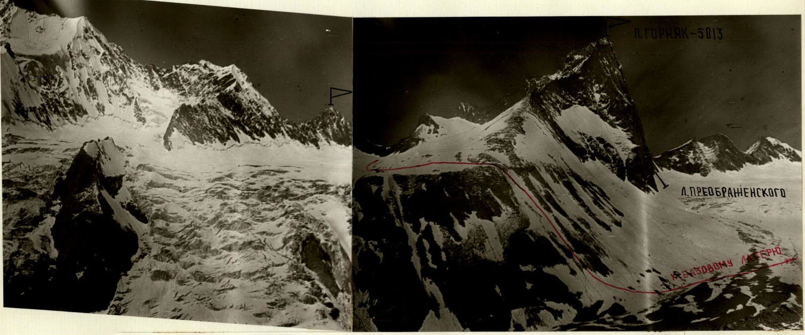
- Peak Gornjak (5013) — via the right edge of the Northern wall. KTM.5.4.1.
- Proposed difficulty category — 6A, combined, first ascent
- Height difference — 1273 m, including: wall — 453 m. Distance — 1710 m. Length of sections with 5–6 difficulty category — 630 m, including: 6th category — 230 m (4160–4200, 4660–4700, 4775–4990). Average steepness — 60° (3740–5013), including: wall — 73° (4560–5013).
- Pitons driven: Rock pitons 92/11 Nuts 87/11 Ice screws 14
- Climbing hours — 34.5, 4 days. Night bivouacs: — 1st and 3rd — lying in a tent — 2nd — split semi-sitting
- Team of Professional Applied Climbing Club "Gornjak"
- Leader — Lenivkova Zinaida Dmitrievna — Master of Sports Team members: — Vasilkov Yuri Viktorovich — Candidate Master of Sports — Kirgirin Valery Anatolyevich — Candidate Master of Sports — Plechkov Andrey Yuryevich — Candidate Master of Sports
- Coach — Master of Sports of the USSR Glushko Vyacheslav Ivanovich
- Departure to the route — July 16, 1990
- Summit ascent — July 19, 1990
- Return — July 19, 1990
Route of the team to Peak Gornjak (5013) via the right edge of the Northern wall, 6A category. First ascent, 1990.
Photo — 1. Date taken — July 19, 1990. Lens — Jupiter-37A. Distance — 1.5 km. Height — 3850 m. Shot number — 1.
PROFILE OF THE ROUTE TO PEAK GORNYAK (5013) VIA THE RIGHT EDGE OF THE NORTHERN WALL, 6A category. View from the left.
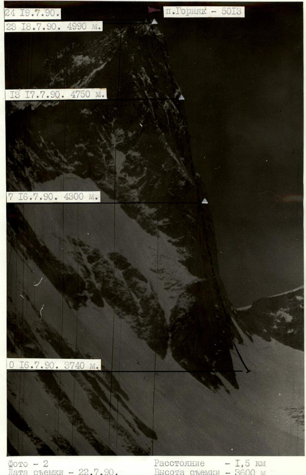
Photo — 2. Date taken — July 22, 1990. Lens — Lubyatel-166. Distance — 1.5 km. Height — 3600 m. Shot number — 2.
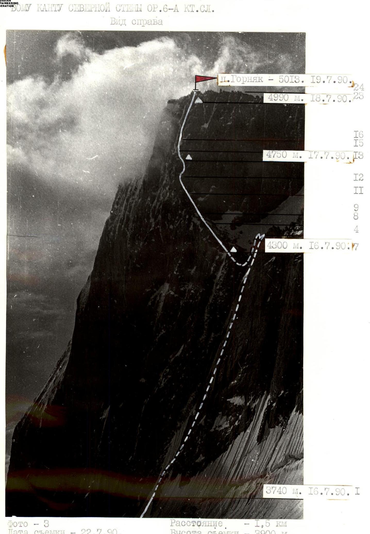
PROFILE OF THE ROUTE TO PEAK GORNYAK (5013) VIA THE RIGHT EDGE OF THE NORTHERN WALL, 6A category. View from the right.
Photo — 3. Date taken — July 22, 1990. Lens — Industar-50. Distance — 1.5 km. Height — 3900 m. Shot number — 3.
PHOTO PANORAMA OF THE AREA.
Photo — 4. Date taken — July 23, 1990. Lens — Industar-50. Distance — 1.5 km. Height — 3500 m. Shot number — 4.
The results of the reconnaissance and the study of photographic materials formed the basis for drawing up a tactical plan. The planned route was scheduled to be completed with 3 overnight stays on the ascent and one day was allocated for descent. In addition, 1 reserve day was planned for bad weather. The team fully implemented their plan. The route was completed from July 16 to 19 for 34.5 climbing hours. The descent from the summit took 12 hours.
Team composition: Lenivkova Z.D. — captain, Vasilkov Yu.V., Kirgirin V.A., Plechkov A.Yu. All participants before the ascent underwent training in the Yaghnob area, had climbs of 5–6 difficulty category in the season.
Since this was a first ascent, there was no specific information about the terrain. This complicated the planning of the ascent, but the actual progress showed the correctness of the assessment of the problematic key areas and the entire route as a whole, which was reflected in the implementation of the tactical plan. In addition, the implementation of the tactical plan was facilitated by an even distribution of the load among team members (every day during the ascent, the leader changed, and as a result, a high pace of movement was maintained).
According to preliminary data, only the 1st night bivouac should be convenient. The ascent schedule was as follows:
July 16. Late departure due to weather conditions — at 9:30. Task of the day — reaching the ridge and organizing a bivouac. Problems: 1. Safe passage of steep, destroyed, icy, and snowy rocks along the snow-ice couloir. Solution — movement in crampons. 2. Reaching the ridge via a monolithic vertical wall. Solution — using high individual technique, passing a 40-meter overhang by free climbing. There were no suitable places for a bivouac on the ridge, so the team had to descend to the southern side (rappel) and dig a platform on a snowy slope. Work completion at 21:30. 780 m covered during the day. Most of the day was rainy with snow, fog.
July 17. Departure at 8:00. Task of the day — reaching the edge, starting work on the summit tower. Problems: 1. Difficulty in orientation when choosing the optimal path in weather conditions. Solution — using observation data, photographic materials, and intuition based on extensive climbing experience. 2. Reaching the night bivouac on the "roof" of the "brick". Solution — traversing the "brick" in the lower part along vertical slabs with limited handholds. The cornice is bypassed on the right along a slab. Uncomfortable, split, semi-sitting night bivouac (1+1+2). Work completion at 20:00. 540 m covered during the day. Snow pellets fell several times during the day, with only about 2 hours without fog, and visibility was within 30–50 m for the rest of the time.
July 18. Departure at 8:00. Task of the day — reaching the summit. Problem: Passing the summit tower — a key section of the route. Solution — from the night bivouac, a rather complex approach along icy slabs, followed by an ice ridge under the wall. The wall becomes vertical, with some overhanging sections (200 m). The path is complex but logical, leading directly to the summit. The entire arsenal of mountaineering techniques is applied, requiring a high level of rock climbing skills from the leader. The wall is passed using IT. Night bivouac on a narrow inclined ledge, one rope length from the summit. Work completion at 18:00. Cloudy weather, dense fog, snowfall starting at 15:00.
July 19. Departure at 8:00. 30 m to the summit, ascent along a steep wall consisting of two slabs. Directly reaching the summit. Good visibility. Determining the descent route: to the southern cirque, informing the base camp. Laying 7 rappel ropes along the counterfort with 3 characteristic jandarms, entering a snowy couloir, and then descending to a snowy plateau. At 19:00, bypassing Peak 5013 from the east, the team returned to the base camp on the Preobrazhensky Glacier.
The tactical movement scheme was as follows:
- Since the participants' preparation was quite strong and even, the lead climber worked without change throughout the entire day. Each day, the lead climbers changed: 1st day — Vasilkov, 2nd day — Plechkov, 3rd day — Kirgirin, and 4th day — Vasilkov. The lead climber worked with a minimally loaded rucksack or without it, depending on the complexity of the section.
- The second climber had a first-aid kit, crampons for passing icy sections and rocks with ice accretion in their rucksack.
- When moving along the rope, participants used 2 jumar-type ascenders and "Petzl" ascenders. On sections R0–R1 and R6–R7, the rope teams moved independently.
Safety measures during the route included: — high physical, technical, tactical, and psychological preparedness of team members; — a tactical plan drawn up taking into account the specifics of the area; — good material support, including the use of modern mountaineering equipment; — ensuring double insurance for all participants on the route, the lead climber working on a double rope (UIAA+USSR); — presence of a safety group under the route (8 people, Master of Sports and Candidate Master of Sports), having a specific plan of action in case of an emergency; — presence of an observation group under the route and stable radio communication with the base camp.
There were no falls or injuries during the ascent.
The route included 2 hot meals and a daily pocket snack. Nutrition was planned at 350 g of products per person per day.
Route Scheme in UIAA Symbols
| Section | Length, m | Steepness, ° | Diff. cat. | Rock pitons | Nuts | Ice screws |
|---|---|---|---|---|---|---|
| R0–R1 | 200 | 50–55 | 3–4 | – | – | 2 |
| R1–R2 | 240 | 55–60 | 4 | 10 | 10 | – |
| R2–R3 | 120 | 60–70 | 5 | 12 | 6 | 2 |
| R3–R4 | 40 | 90 | 6 | 6 | 2 | – |
| R4–R5 | 40 | – | 4 | – | 5 | – |
| R5–R6 | 40 | 90 | 4 | – | 2 | – |
| R6–R7 | 100 | 50 | 3 | 4 | 6 | – |
| R7–R8 | 200 | 50 | 3–4 | 4 | 4 | 2 |
| R8–R9 | 100 | 50–55 | 4 | 4 | 4 | 2 |
| R9–R10 | 40 | 50–55 | 4 | 2 | 2 | – |
| R10–R11 | 120 | 60–70 | 5 | – | 12 | – |
| R11–R12 | 40 | 80 | 5 | 4 | 2 | – |
| R12–R13 | 40 | 80 | 6 | 5/2 | 4/2 | – |
| R13–R14 | 20 | 80 | 5 | 2 | 2/1 | – |
| R14–R15 | 20 | 60 | 5 | 2 | 4/1 | – |
| R15–R16 | 40 | 60 | 5 | – | – | 5 |
| R16–R17 | 15 | 95 | 6 | 4/2 | 2/1 | – |
| R17–R18 | 25 | 80 | 6 | 6/2 | 4/1 | – |
| R18–R19 | 25 | 85 | 6 | 6/3 | 2/1 | – |
| R19–R20 | 15 | 80 | 6 | 2/1 | 2 | – |
| R20–R21 | 40 | 80 | 6 | 5 | 3/2 | – |
| R21–R22 | 10 | 75 | 5 | – | 2 | – |
| R22–23 | 30 | 80 | 6 | 4/1 | 3/1 | – |
| R23–R24 | 30 | 75 | 5 | 2 | 2/1 | 1 |
| Total | 1710 | 92/11 | 87/11 | 14 |
Route Description by Sections
Section R0–R1. Start of the route from the snowy plateau of the Preobrazhensky Glacier. Ascent along the right part of the snow-ice couloir. After 100 m, cross the bergschrund via a snow bridge and continue to the right rocky edge of the couloir. Crampons needed. 200 m, 50–55°, 3–4 diff. cat.
Section R1–R2. Icy, snowy, and destroyed rocks on the right edge of the couloir. 240 m, 55–60°, 4 diff. cat.
Section R2–R3. Character of the rocks remains (walls, ledges, flakes). Steepness increases. Difficulties arise with organizing insurance, few cracks. 120 m, 60–70°, 5 diff. cat.
Section R3–R4. Key section when exiting to the ridge. Vertical wall with two fissures. Ascent via free climbing using the fissures. Very tense climbing. 40 m, 90°, 6 diff. cat.
Section R4–R5. Ridge. Move left towards the summit. The ridge is monolithic, complex, and is traversed by free climbing. 40 m, 10°, 4 diff. cat.
Section R5–R6. Descent from the ridge to the southern side, rappel. 40 m, 70–90°, 4 diff. cat.
Section R6–R7. Snowy slope on the right, southern side of the ridge. Ascent along the rocks. 100 m, 50°, 3 diff. cat. Night bivouac site on a snowy slope.
Section R7–R8. Snowy and icy rock slabs and "islands". 200 m, 50°, 3–4 diff. cat.
Section R8–R9. Character of the route remains. Steepness increases. 100 m, 50–55°, 4 diff. cat.
Section R9–R10. Snowy rocks lead to the ridge. 40 m, 50–55°, 4 diff. cat.
Section R10–R11. Movement towards the characteristic flake (conditional name "brick") via a system of walls. Rocks are monolithic, steep. 120 m, 60–70°, 5 diff. cat.
Section R11–R12. Steep wall leads to an overhang. Handholds are limited. The wall is rough. Insurance organization is complex, climbing is difficult. 40 m, 80°, 5 diff. cat.
Section R12–R13. Movement along the internal angle under the "brick". Very steep. Rocks are difficult. Cracks are vertical, narrow, with sharp edges. The cornice is bypassed on the right along a slab. Exit to the "brick" is one of the key sections of the route. 40 m, 80°, 6 diff. cat. Possible site for a split night bivouac on small "tiles".
Section R13–R15. First along the wall, then along the snowy slab, exit to the snow-ice ridge. 40 m, 60–80°, 5 diff. cat.
Section R15–R16. Steep snow-ice ridge intersects the couloir and leads under the vertical, partially overhanging 200-meter wall. Insurance via ice screws, ice axe, and crampons needed. 40 m, 60°, 5 diff. cat.
Section R16–R17. Overhanging wall with a fissure on the right of the internal angle. IT used. 15 m, 95°, 6 diff. cat.
Section R17–R18. Steep wall with a fissure, turning into an internal angle with smooth walls. Climbing is complex. Few handholds. Stoppers used. 25 m, 80°, 6 diff. cat.
Section R18–R19. Smooth slab. Few handholds. IT used. Thin pitons used. 25 m, 85°, 6 diff. cat.
Section R19–R20. Wall turning into an internal angle with smooth edges. Climbing is complex. Small stoppers and pitons used. 15 m, 80°, 6 diff. cat.
Section R20–R21. Blocky rocks. Micro-relief is limited. Climbing is complex. 40 m, 80°, 6 diff. cat.
Section R21–R22. Ascent along the fissure between two slabs, left of the ice couloir. 10 m, 75°, 5 diff. cat.
Section R22–R23. Smooth slabs lead to a small inclined ledge. Possible night bivouac site. 30 m, 80°, 6 diff. cat.
Section R23–R24. Ascent along the slab left of the overhang. Climbing is complex. Cracks are filled with ice. Direct exit to the summit. 30 m, 75°, 5 diff. cat.
Descent. Descent to the south, along the counterfort with three characteristic jandarms. Laying 7 rappel ropes, exit to a snowy couloir, and then descent to the plateau of the southern cirque of the Preobrazhensky Glacier.
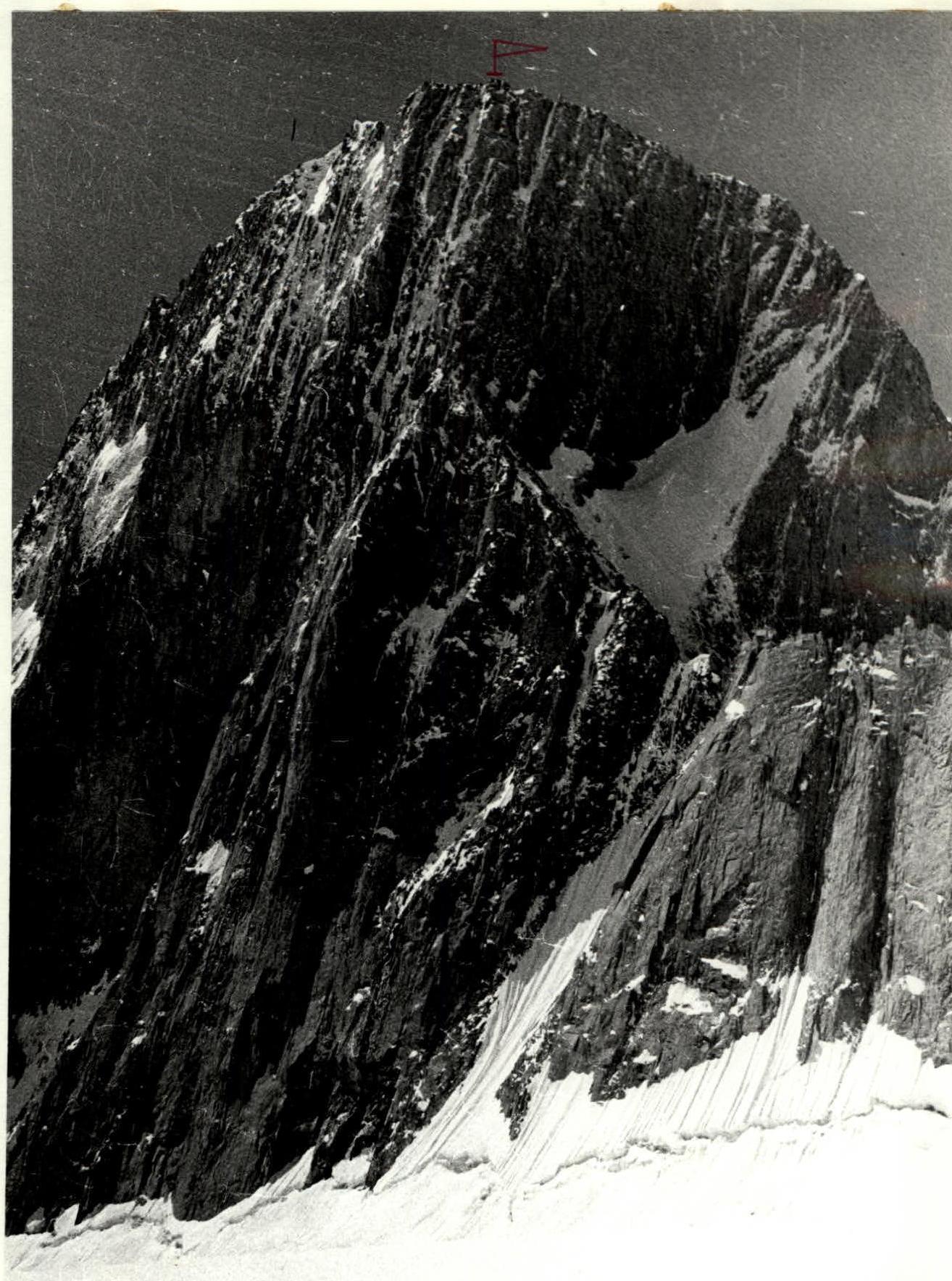
Photo — 6. Peak Gornjak — 5013 m. View from the Preobrazhensky Glacier.
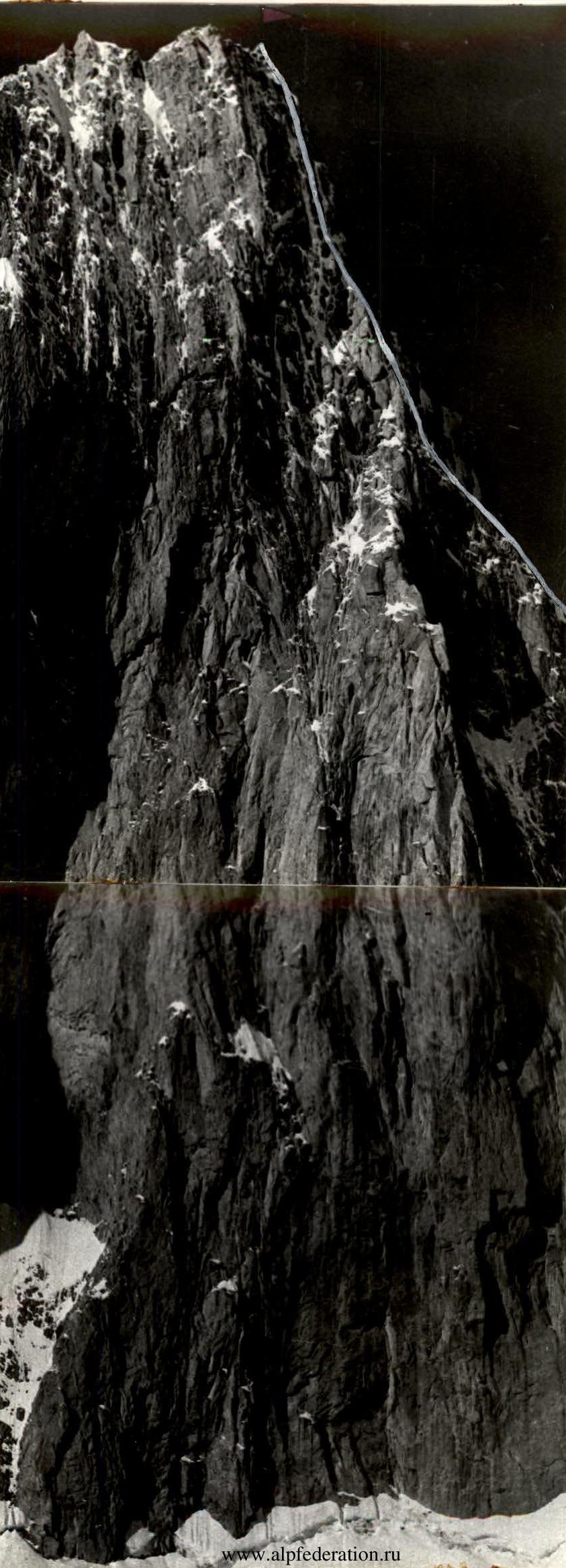
Photo — 7. Right edge of the Northern wall of Peak Gornjak.
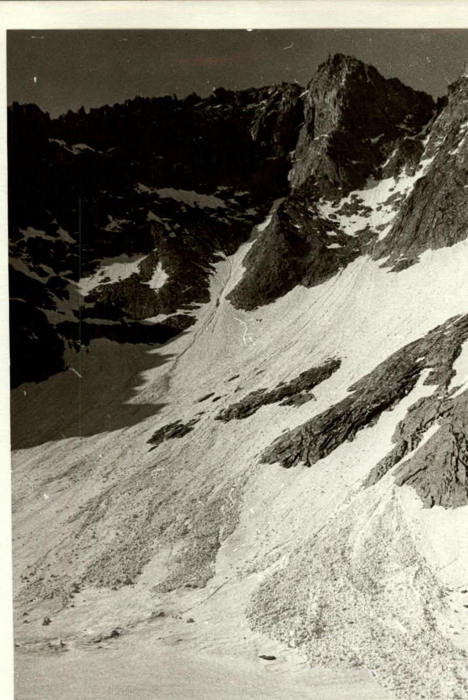
Photo — 13. Descent route from Peak Gornjak.
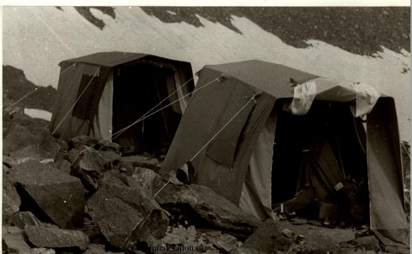
Photo — 14. Base camp on the median moraine of the Preobrazhensky Glacier.