Ascent Passport
- Pamir-Alay, Karavshin valley, 5.4.3
- Peak Asan, via the left part of the NW wall.
- Proposed — Category 6B difficulty, first ascent
- Route type: rock
- Route height difference: 930 m (3300–4230)
- Route length: 1010 m.
Section lengths: Category V difficulty – 105 m, Category VI difficulty – 710 m. Average steepness: main part of the route – 89°, entire route – 74°. Number of pitons left on the route: total – 32; including bolted pitons – 32. Pitons used on the route: bolted stationary – 32, including artificial aids – 19; removable bolted – 0, including artificial aids – 0. Total artificial points of support (AID) used – 150. Team's walking hours: 90.5 hours, 11 days. Team leader: Mohyla Volodymyr Fedorovych — Master of Sports
- Participants:
Lavrinenko Oleksandr Vadymovych — Candidate for Master of Sports; Nikolaev Vadym Valeriyovych — Candidate for Master of Sports; Cheban Viarel Ivanovych — 1st sports category
- Coach: Horbenko Mstyslav Mstyslavovych — Honored Master of Sports, Honored Coach
- Departure to the route: 7:30 AM, July 24, 2004
Reached the summit: 11:00 AM, August 3, 2004. Returned to Base Camp: 1:00 PM, August 4, 2004.
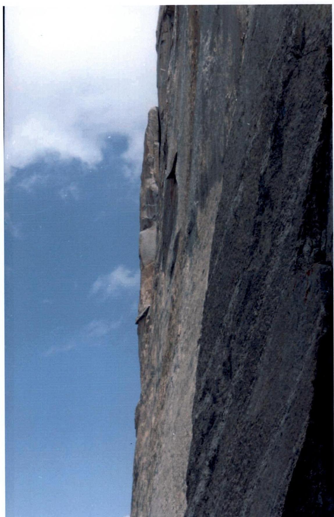
Profile of the upper part of the route (view from the left). Photo by S. Pugachev.
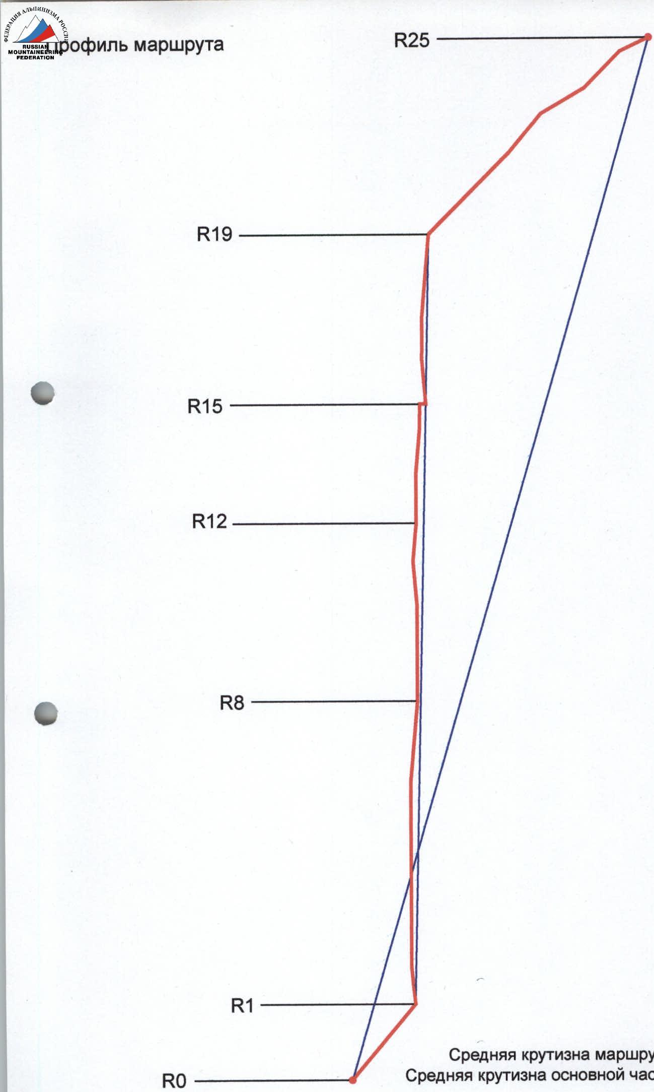
Average steepness of the route R0–R25 – 74° Average steepness of the main part R1–R19 – 89°
Brief description of the route and team actions
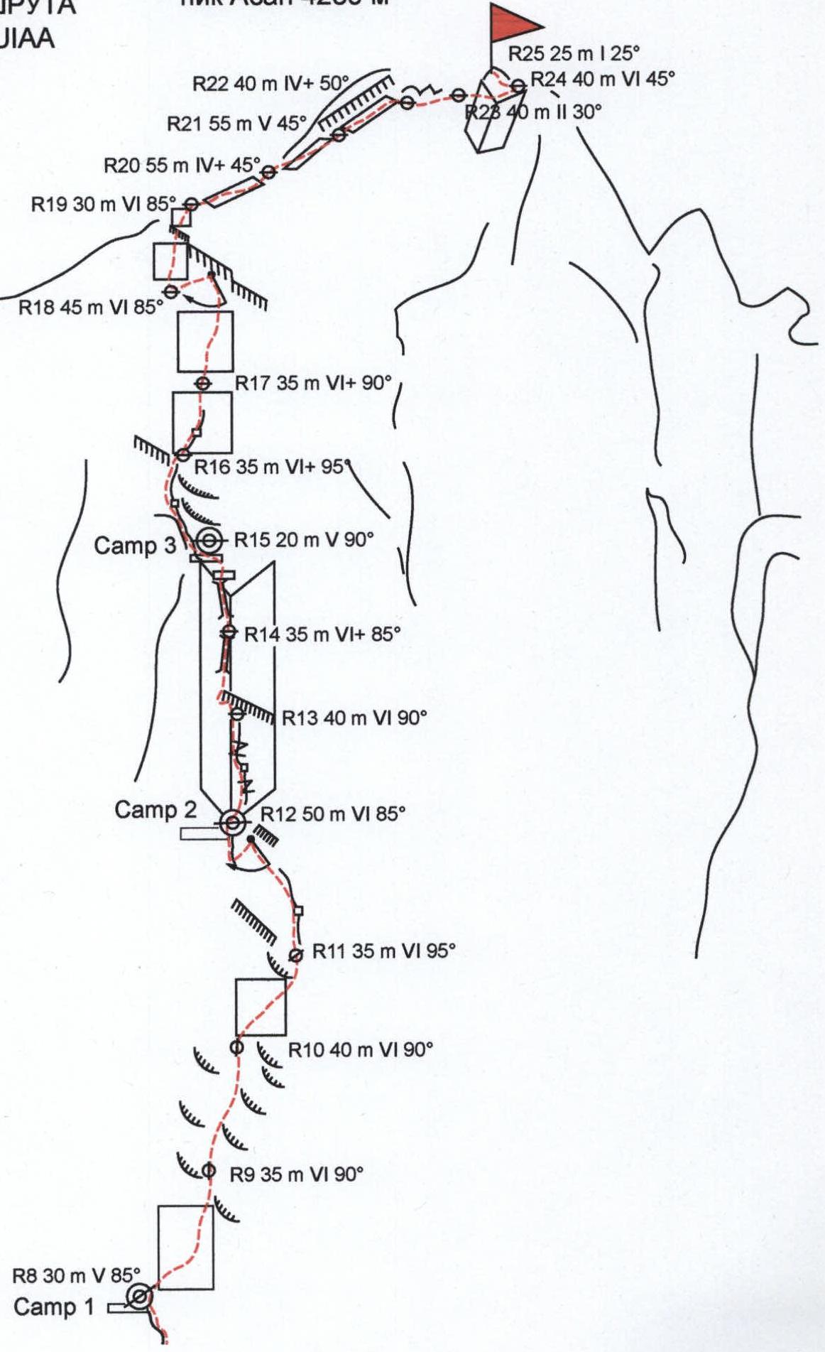
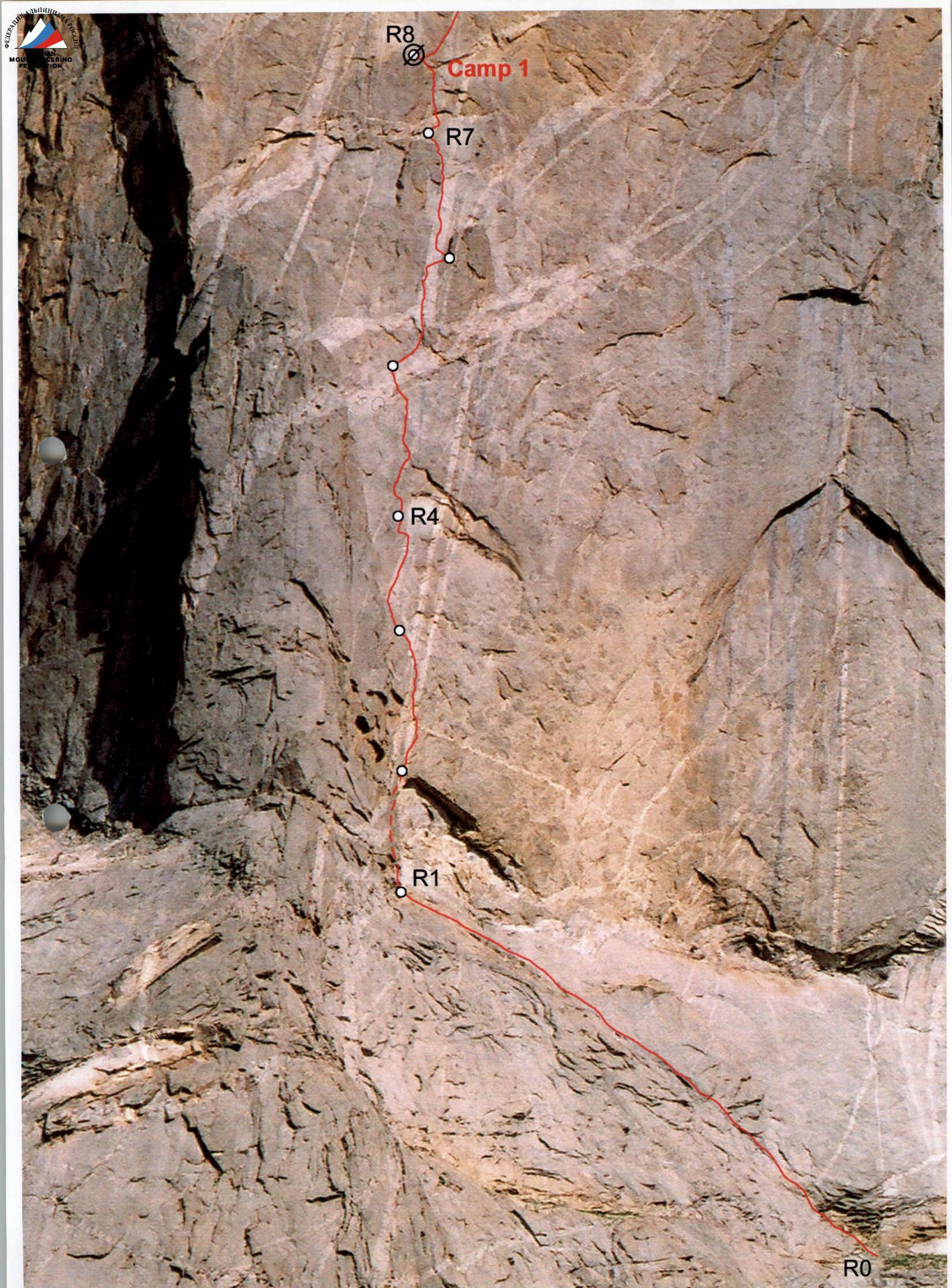
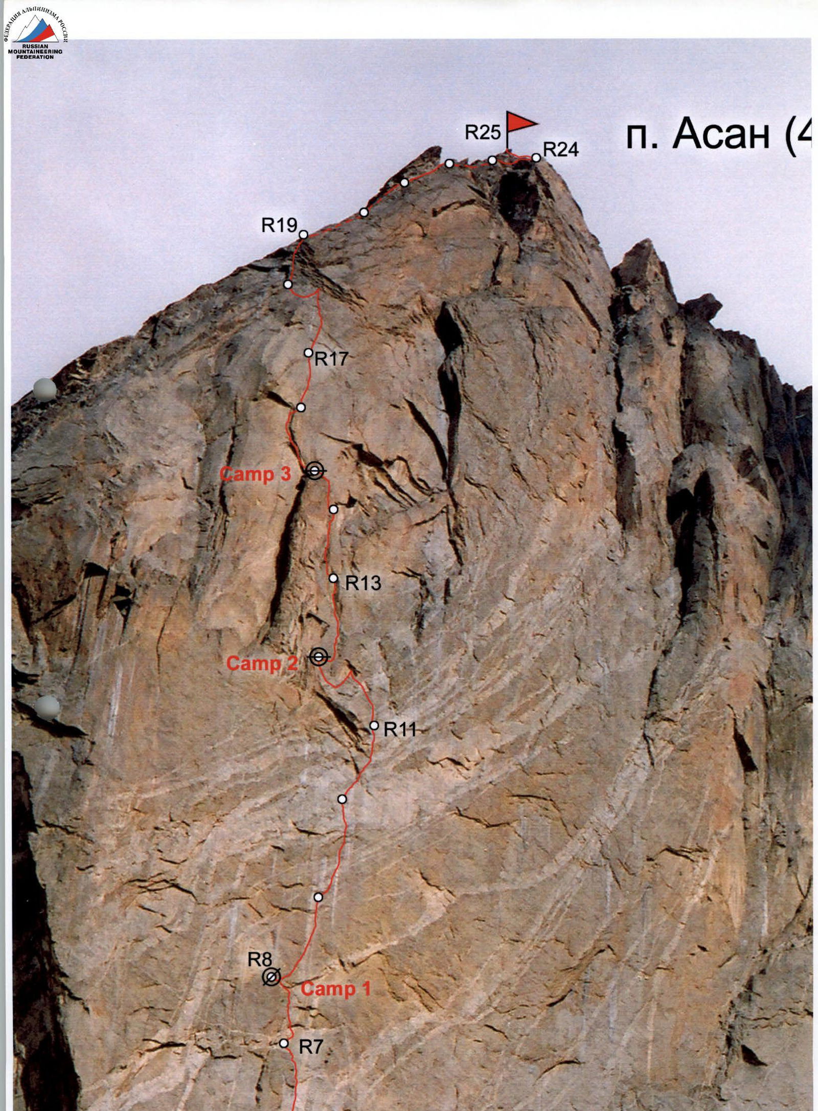
The route goes through the left part of the NW wall. The rocks are monolithic granites. The route is generally objectively safe. It can be conditionally divided into five parts.
-
R1–R7 — complex steep rocks (partially overhanging), average steepness 90°, with eaves. Cracks are clogged with stones (need to be cleaned), difficult to set up belays. A large set of varied gear was used, including large "camalots", small anchor pitons — "hatchets", "sky-hooks".
-
R7–R12 — bypassing a series of overhangs and eaves on the right (coincides with M. Horbenko's route (1996)). R8–R11 — steep, monolithic rocks, with overhangs and eaves. Average steepness 90°. Scarce terrain. The section was traversed in 1996 by M. Sitnik. Movement was mainly on AID using "sky-hooks".
-
R12–R15 — movement along the right side of a large flake ("Phallus"). Beautiful, complex climbing and AID on large cracks and "chimneys".
-
R15–R19 — complex, overhanging rocks in the first quarter. Movement was mainly on AID through cracks and flakes. At the end of R17–R18, a pendulum swing to the left, bypassing a large eave.
-
R19–R25 "roof" — gently sloping slab-like rocks leading to the summit.
For belay stations, bolted pitons (Ø10 mm, L450 mm) were additionally used.
For bivouac organization, the team used two two-person platforms "BLACK DIAMOND". The style of ascent was capsule with the use of 5 sixty-meter ropes (2 ropes "BEAL" Ø10 mm, 2 — "LANEX" Ø9 mm, and 1 rope Ø10 mm from Kolomna production). All participants took turns leading.
Three bivouacs were set up on the route.
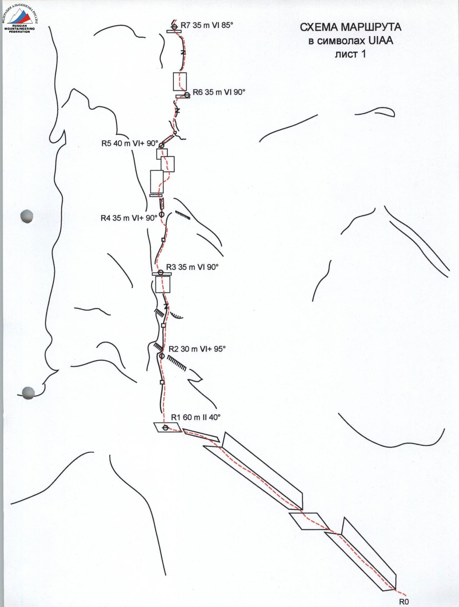
Route diagram of Peak Asan 4230 m in UIAA symbols R25 25 m I 25° sheet 2 R24 40 m VI 45° R20 55 m IV+ 45° R19 30 m VI 85°
Team movement schedule by sections
- July 24, 2004, 7:30 AM to 3:00 PM — began route processing (sections R0–R2)
- July 24, 2004, 3:00 PM — rain
- July 25, 2004, 8:00 AM to 6:00 PM — processing (R2–R4)
- July 26, 2004, 8:00 AM to 4:00 PM — processing (R4–R5)
- July 26, 2004, 3:00 PM — rain
- July 27, 2004, 8:00 AM to 7:00 PM — processing (R5–R7)
- July 27, 2004, 5:00 PM to 6:00 PM — rain
- July 28, 2004, 7:30 AM to 4:00 PM — traversed sections R7–R10, overnight stay at Camp 1 (R8)
- July 28, 2004, 4:00 PM — rain
- July 29, 2004, 8:30 AM to 1:00 PM — traversed section R10–R11, overnight stay at Camp 1 (R8)
- July 29, 2004, 10:00 AM to evening — rain
- July 30, 2004, 8:00 AM to 6:00 PM — traversed sections R11–R13, overnight stay at Camp 2 (R12)
- July 31, 2004, 8:00 AM to 6:00 PM — traversed sections R13–R15, overnight stay at Camp 3 (R15)
- August 1, 2004, 8:00 AM to 4:00 PM — traversed sections R15–R17, overnight stay at Camp 3 (R15)
- August 1, 2004, 4:00 PM — rain
- August 2, 2004, 8:00 AM to 6:00 PM — traversed sections R17–R19, overnight stay at Camp 3 (R15)
- August 3, 2004, 8:00 AM to 11:00 AM — traversed sections R19–R25
at 11:00 AM — reached the summit
- 12:30 PM — began descent via the ascent route
- August 4, 2004, 1:00 PM — returned to Base Camp.