Ascent Log
I. Technical category 2. Pamir-Alay, Turkestan Ridge, Kara-Suu gorge 3. Peak Petrogradets (5163 m) via the eastern edge from the saddle between Peak Iskander (5120) 4. Proposed - 5B category of difficulty, first ascent 5. Elevation gain: 1413 m, route length - 1850 m Length of sections with 5-6 category of difficulty - 820 m. Average steepness of the main part of the route - 70° (4190-5000), including 6 category of difficulty - 85° (4720-4760), 60° (4760-4763), 105° (4810-4815)
- Pitons driven
| Rock | Ice | Nuts | Bolts |
|---|---|---|---|
| 62 | 73 | 13 | none |
-
Team's travel time: 42 hours and days - 4
-
Overnight stays: 1st platform, carved on a snow-ice saddle for 4 people; 2nd - 3rd - on a rocky talus shelf, a stone platform for 4 people.
-
Team leader: Borodin Sergey Alekseyevich - Candidate for Master of Sports Team members: Kulagin Alexander Alekseyevich - 1st sports category, Kalokin Nikolay Markovich - 1st sports category, Salin Nikolay Vasil'evich - 1st sports category
-
Coach: Vorobyev Boris Valentinovich - Candidate for Master of Sports.
-
Start of the route: August 17, 1983 summit: August 19, 1983 return: August 20, 1983
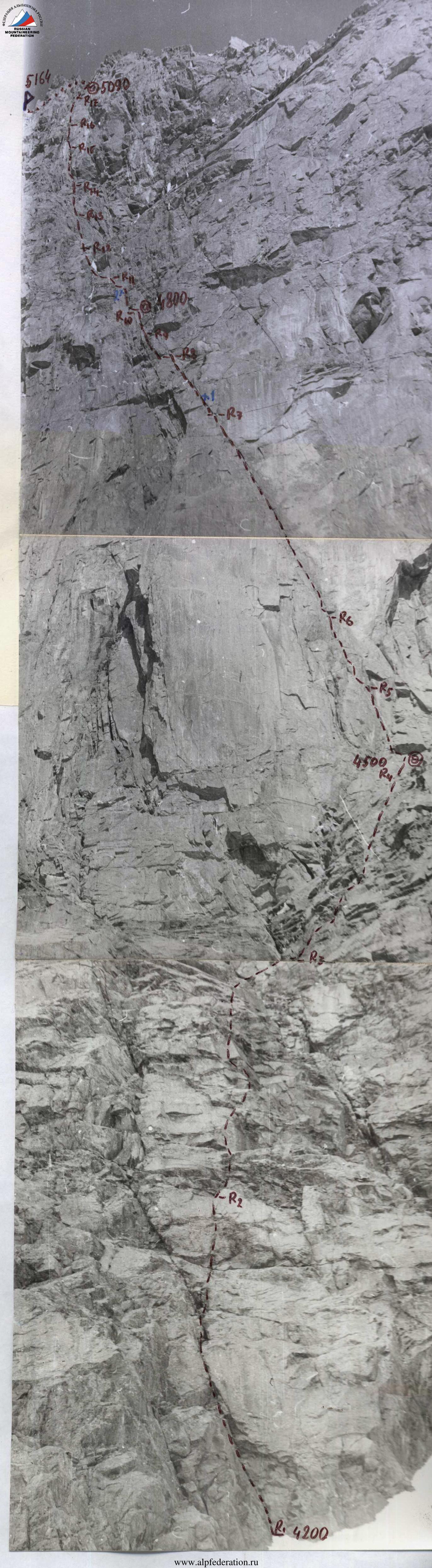
The eastern edge of Peak Petrogradets (5163 m) photographed from the western ridge of Peak Iskander on August 21, 1983 at 9:00. Camera "Zenit-E", lens "Helios-44", f = 58 mm. Distance to the object - 300 m.
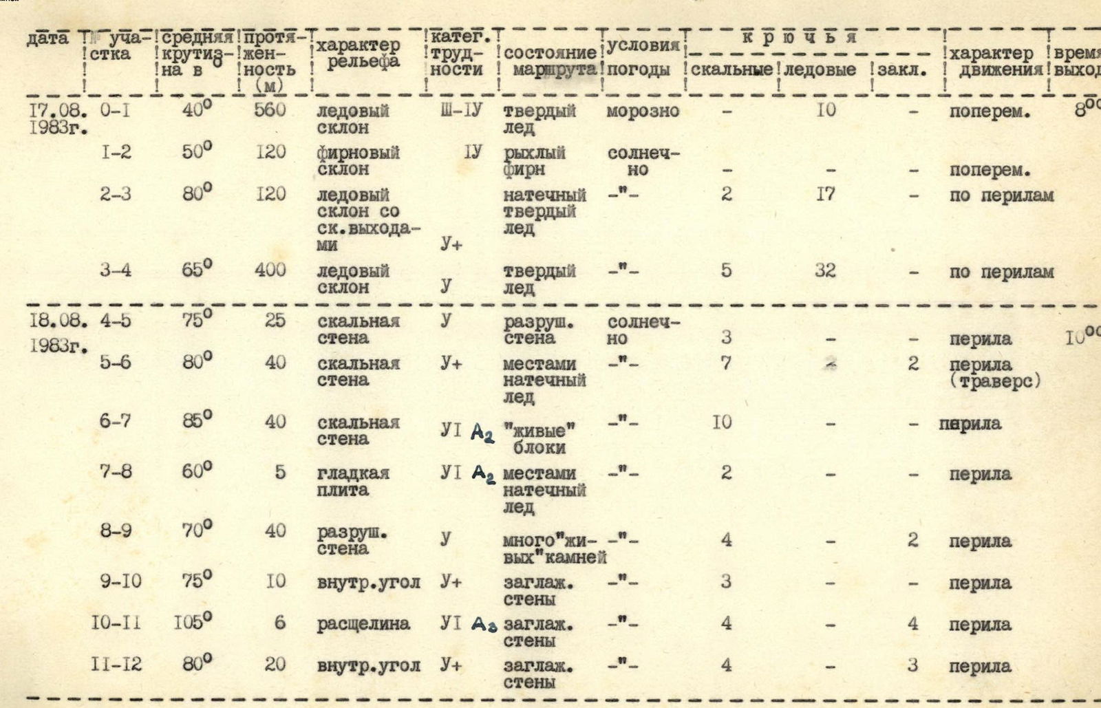
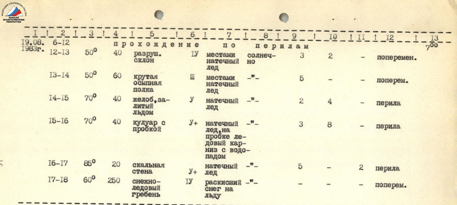
| Date | Section | Average steepness | Length (m) | Terrain characteristics | Category of difficulty | Route condition | Weather conditions | Rock | Ice | Nuts | Movement type | Departure time |
|---|---|---|---|---|---|---|---|---|---|---|---|---|
| 17.08.1983 г. | R0–R1 | 40° | 560 | Ice slope | 3 | Hard ice | Frosty | 10 | – | – | Alternating | 8:00 |
| R1–R2 | 50° | 120 | Snow slope | 4 | Loose snow | Sunny | – | – | – | Alternating | ||
| R2–R3 | 80° | 120 | Ice slope with rock outcrops | 4 | Hard ice | – | 2 | 17 | – | Roped | ||
| R3–R4 | 65° | 400 | Ice slope | 3 | Hard ice | – | 5 | 32 | – | Roped | ||
| 18.08.1983 г. | R4–R5 | 75° | 25 | Rock wall | 4 | Unstable rock | Sunny | 3 | – | – | Roped | 10:00 |
| R5–R6 | 80° | 40 | Rock wall | 4 | Some ice | – | 7 | – | 2 | Roped (traverse) | ||
| R6–R7 | 85° | 40 | Rock wall | 5 | "Live" blocks | – | 10 | – | – | Roped | ||
| R7–R8 | 60° | 5 | Smooth slab | 5 | Some ice | – | 2 | – | – | Roped | ||
| R8–R9 | 70° | 40 | Unstable wall | 4 | Many "live" stones | – | 4 | – | 2 | Roped | ||
| R9–R10 | 75° | 10 | Inner corner | 4 | Smooth walls | – | 3 | – | – | Roped | ||
| R10–R11 | 105° | 6 | Crevice | 6 | Smooth walls | – | 4 | – | 4 | Roped | ||
| R11–R12 | 80° | 20 | Inner corner | 4 | Smooth walls | – | 4 | – | 3 | Roped | ||
| 19.08.1983 г. | R12–R13 | 50° | 40 | Unstable slope | 4 | Some ice | Sunny | 3 | 2 | – | Alternating | 7:00 |
| R13–R14 | 50° | 60 | Steep talus shelf | 3 | Some ice | – | 5 | – | – | Alternating | ||
| R14–R15 | 70° | 40 | Gully filled with ice | 3 | Ice | – | 2 | 4 | – | Roped | ||
| R15–R16 | 70° | 40 | Gully with a plug | 4 | Ice, ice cornice with waterfall | – | 3 | 8 | – | Roped | ||
| R16–R17 | 85° | 20 | Rock wall | 4 | Ice | – | 5 | – | 2 | Roped | ||
| R17–R18 | 60° | 250 | Snow-ice ridge | 4 | Soaked snow on ice | – | – | – | – | Alternating |
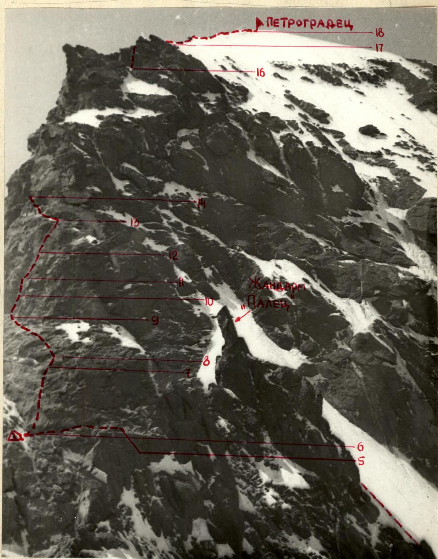
Route description to Peak 5163 (Petrogradets) via the eastern edge by sections
SECTION R0–R1. Ice slope with an average steepness of 40°. In the second half, many ice crevasses appear, mostly open and snow-covered. Few bridges, often need to find a detour. The slope approaches the first bergschrund, which is overcome via a snow bridge on the right side.
SECTION R1–R2. Snow slope between the first and second bergschrunds. Belaying only through an ice axe.
SECTION R2–R3. Rocks like "ram's foreheads", covered with ice. Passage through ice gullies between rocks. Convenient ledges for belaying on stones protruding from the ice. Periodically hit by ice fragments from the ice couloir.
SECTION R3–R4. Ice couloir 20-30 m wide. When moving, stick to the left (in the direction of travel) side of the couloir; the right side is hit by ice fragments falling from Petrogradets walls. The couloir leads to a saddle. By cutting the top of the saddle, it's possible to set up a tent. 4-5 m down on the southern side - a small hollow where it's also possible to set up a tent.
SECTION R4–R5. From the hollow, climb a 25 m vertical rock "pillar".
SECTION R5–R6. Traverse 40 m to the left, along a steep wall, on a narrow rock ledge 10-15 cm wide. In the middle part, the ledge is intersected by an ice groove, overcome with a small "pendulum". Then, again on a narrow ledge to a 3 × 5 m shelf, where a stone platform is built for a tent. Over-night stay is lying down, safe, with water available in the form of ice.
SECTION R6–R7. Straight up from the platform, along a steep wall with few handholds.
SECTION R7–R8. The wall turns into a smooth slab with a steepness of 60°, without handholds or cracks for pitons. Used artificial aids and "sky" pitons.
SECTION R8–R9. Further movement along a severely destroyed wall (many "live" stones and blocks) in a screw-like fashion, left-up, bypassing a tower, to an inner corner. There are ledges for belaying.
SECTION R9–R10. Inner corner with smooth walls, passed on friction in galoshes, on slings. Nuts (medium stoppers) fit well.
SECTION R10–R11. Crevice with overhanging walls. Passed in a "Zalzug" on artificial support points. Crevice width is 8-12 cm; large "hexes" and wedge-boxes fit well.
SECTION R11–R12. Inner corner with smooth walls, similar to section R9-R10.
SECTION R12–R13. Severely destroyed rock wall, partially covered with ice; movement straight up under the base of a rock tower.
SECTION R13–R14. Along a steep talus shelf, partially covered with ice, left, bypassing a tower, to an ice gully.
SECTION R14–R15. Movement up an ice gully to a large rock plug, through which an ice flow pours. Increased caution is required when passing; stones may fall from above.
SECTION R15–R16. Begins with overcoming the "plug". The "plug" is overcome on ice, sometimes overhanging up to 90-100°. Then the gully becomes less steep, up to 70°. On a sunny day, a stream flows through the gully. Be cautious when passing the gully; stones may fall from above.
SECTION R16–R17. The gully abuts a rock wall with ice. The wall is overcome left-up to a ridge.
SECTION R17–R18. Snow-ice ridge, dropping on the southern side with a rock wall, and on the northern side - with an ice slope. Belaying through an ice axe when passing.