I. Climbing category: technical.
- Climbing area: Pamir-Alai, Turkestan Range.
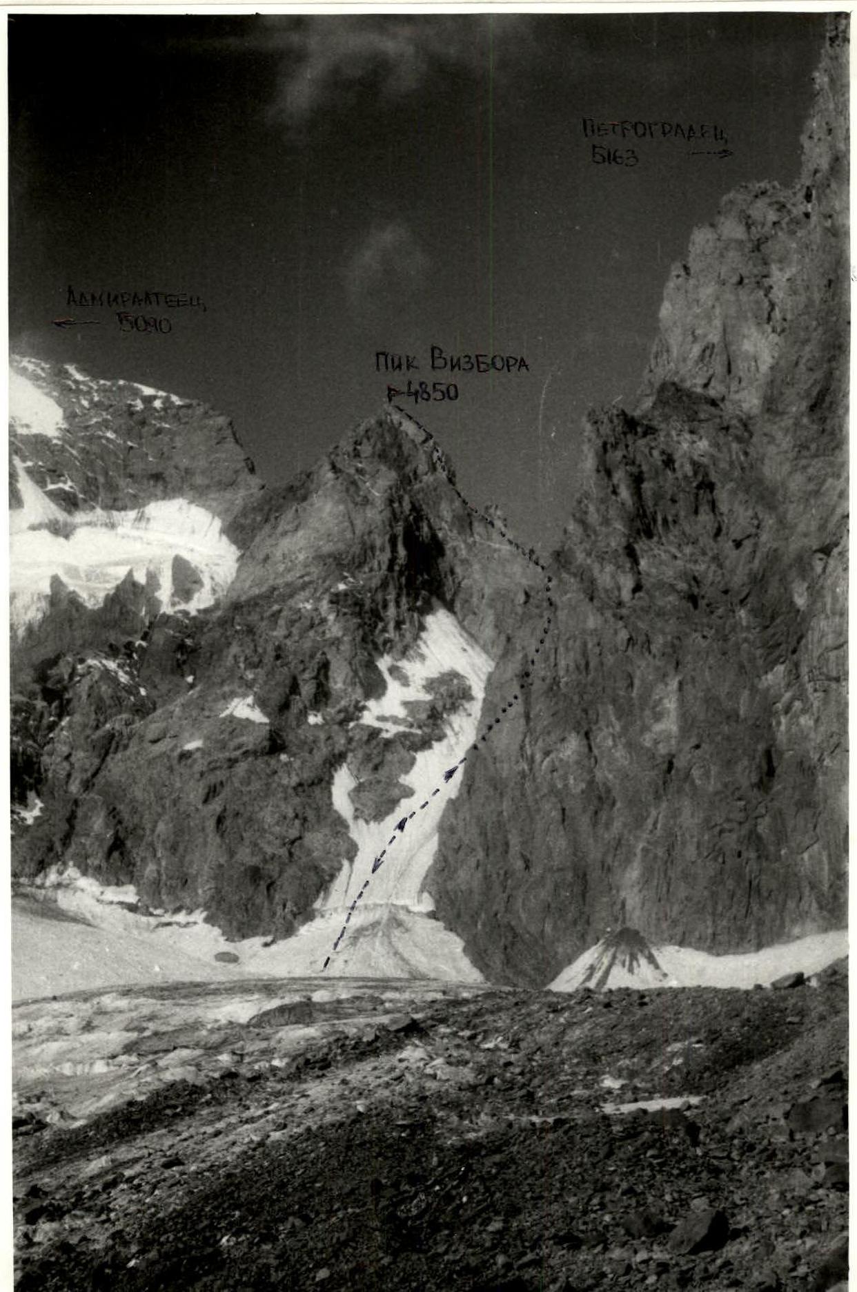
- Summit: 4850 m (Vizbor Peak) via the northern edge, combined.
- Estimated complexity category: 5A
- Route characteristics: height difference — 650 m; length of sections 5–6 c/tr — 190 m; average steepness of the route's rocky part — 55°.
- Pitons hammered: for belaying — 30 (6), chocks — 40.
- Duration: 20 hours.
- Camping: comfortable, on ridges — 2.
- Team members: Kavunenko Vladimir Dmitrievich — MSMK
Grakovich Valentin Fedorovich — MS, Korolev Alexey Vladimirovich — CMS, Lisetsky Vladimir Anatolyevich — CMS
- Team coach: Kavunenko V.D.
II. Date of departure and return: July 26, 1986 — July 28, 1986.
- Organization: "Spartak" Moscow.
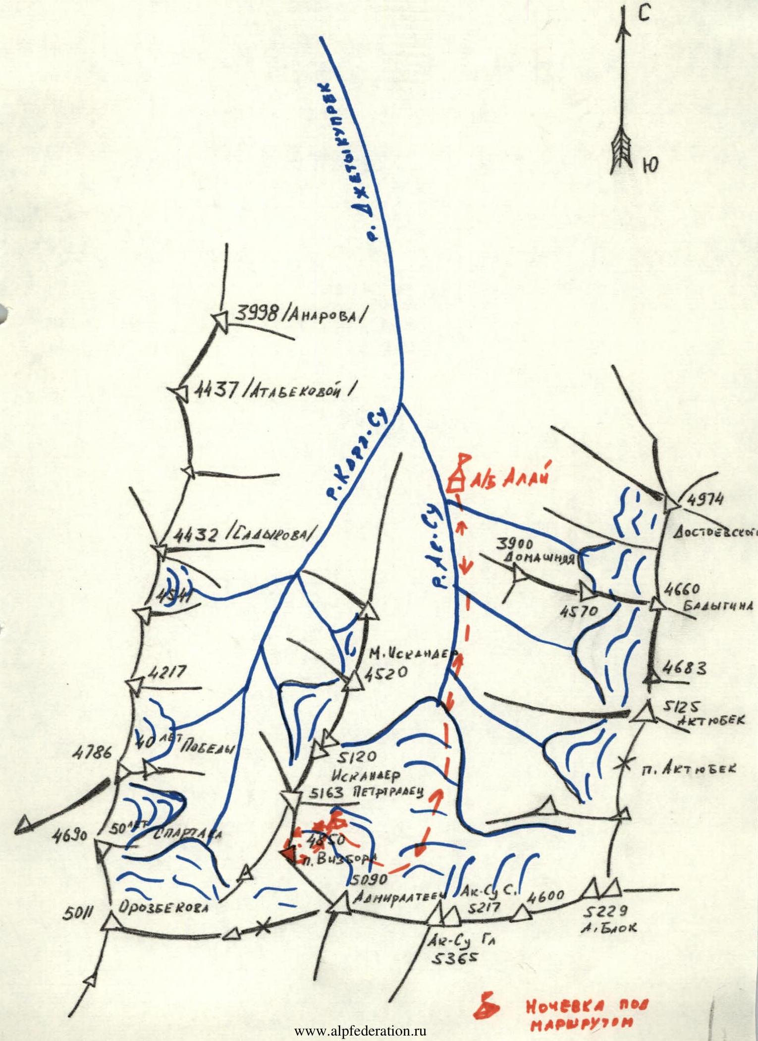
Area map
Approach to the route description
The 4850 m summit (Vizbor Peak) is located in the Ak-Su glacier cirque, in the ridge between the Admiralteets (5090) and Petrogradets (5163) peaks. From the base camp in the Ak-Su valley, follow the trail on the right bank of the Ak-Su River to the terminal moraine of the Ak-Su glacier. Ascend the right moraine to the glacier and then move under the walls of Ak-Su and Admiralteets, climbing up to the glacier cirque between the Admiralteets, Petrogradets, and Iskander peaks. The initial bivouac is on the right-hand moraine under the southern wall of Iskander Peak. The journey from the base camp takes 5–6 hours. From the bivouac on the moraine, ascend directly to the ridge between the 4850 m peak and Petrogradets; this is the starting point of the route, 30 minutes.
Description of the first ascent route to Vizbor Peak (4850 m), approximately 5A c/tr
From the ridge between Petrogradets and Vizbor Peak, ascend a rock ridge for one rope length (40 m) to the first pinnacle. Belaying is done through rock outcrops. Then ascend the pinnacle for 20 m. The pinnacle's summit consists of two "wings." Traverse along a narrow ledge (a psychologically challenging spot).
From the pinnacle's summit, rappel down 20 m to a narrow ridge. Bypass the second pinnacle on the right via narrow ledges covered in ice and snow. Use piton protection. Then ascend to the ridge for 20 m via rocks.
From the ridge, a rock wall with an overhanging section (ice, snow) is ascended on the right. A wide crevice (10–30 cm) is climbed by free climbing, leading to the third pinnacle. The pinnacle is traversed under the rock overhangs on the right, using several "pendulums" to the right and entering an ice-filled inner corner (section 7-II), and then reaching a rock section that leads to the ridge.
It is possible to traverse the pinnacle on the left via very difficult rocks using artificial aids.
There is a camping area on the ridge (tent). Reaching this point takes 6–8 hours.
From the narrow ridge between the pinnacle and the summit (the route's key location), ascend difficult rocks using artificial aids into an inner corner. Then ascend a smooth rock slab up and to the right (bolted piton) and transition to the start of a chimney filled with ice, leading to the shoulder of the sub-summit. The chimney is ascended directly (short ice screws, crampons).
In the middle of the chimney, there is an overhanging wall covered in ice. From the sub-summit shoulder, ascend slabs (ice, snow) to the ridge that leads to the summit. Camping is possible below the summit (space for a tent).
Descend from the summit down the northern rock ridge to the ridge between Vizbor Peak and Admiralteets. From the ridge, descend via snow and ice fields and the glacier that flows from the main Admiralteets summit to the moraine under Iskander Peak.
The total duration is 20 hours. Crampons are necessary for all participants.
Recommended equipment:
- Large and medium-sized chocks — 10 pieces.
- Short ice screws — 5 pieces.
- Rock pitons (angled, boxed, combined, petal-shaped) — 25–30 pieces.
 Vizbor Peak
 Sections R1–R16 are traversed behind the ridge on the right