
Ascent Passport
- Ascent category — combined
- Ascent area — "Pamiro-Alay Turkestansky" ridge
- Peak, its height, route — Peak 5125 m via the northern counterfort of the Western ridge.
- Estimated difficulty category — 5A.
- Route characteristics:
- Height difference: 1825 m
- Length of sections with 5th difficulty category: 400 m
- Average steepness of walls: 60°, up to 70°.
- Pitons hammered:
- for belay: 108
- for creating I.T.O.: 8
- Number of climbing hours — 27
- Number of overnight stays and their characteristics — one, lying down.
- Full name of the leader, participants, and their qualifications:
- Mikhalchenko Stanislav Konstantinovich — 1st sports category
- Baskakova Svetlana Nikolaevna — 1st sports category
- Team coach: Shabanov A.V.
- Date of departure and return: July 17, 1983 – July 19, 1983.
9.1. Observers:
Yagudin Ravil Zaripovich — 1st sports category, Ponkratov Alexander Ivanovich — 2nd sports category.
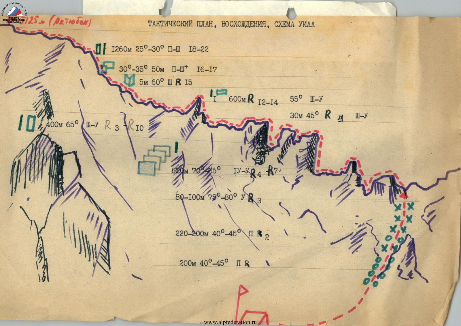
Tactical ascent plan, UIAA scheme
| Date | Designation | Average steepness | Length in m | Terrain characteristics | Difficulty | Condition | Weather conditions | Rock pitons | Placements |
|---|---|---|---|---|---|---|---|---|---|
| 17.07 | R0–R1 | 45° | 220 m | ice, snow | 2 | snow crust | good | - | - |
| R1–R2 | 45° | 200 m | ice, snow | 2 | snow crust | good | - | - | |
| R2–R3 | 75° | 80 m | ice wall | 5 | ice | good | 4 ice screws | - | |
| R3–R4 | 30° | 30 m | ledge | 2 | destroyed | -"- | - | - | |
| R4–R5 | 75° | 40 m | wall | 5 | destroyed | -"- | 6 | - | |
| R5–R6 | 60° | 150 m | ledges, walls | 5* | destroyed | -"- | 13 | 4 | |
| R6–R7 | 50° | 240 m | ridge, sentry | 4 | monolith, destroyed | -"- | 12 | 2 | |
| R7–R8 | 80° | 80 m | wall | 5 | monolith, loose rocks | -"- | 14 | - | |
| R8–R9 | 50° | 320 m | ridge, sentry | 4–3 | monolith, loose rocks | -"- | 23 | 7 | |
| R9–R10 | 75° | 40 m | wall, ice, snow | 5 | monolith, rocks | -"- | 5 | 1 | |
| R10–R11 | 45° | 30 m | finger to the right | 3 | ice, snow | -"- | - | - | |
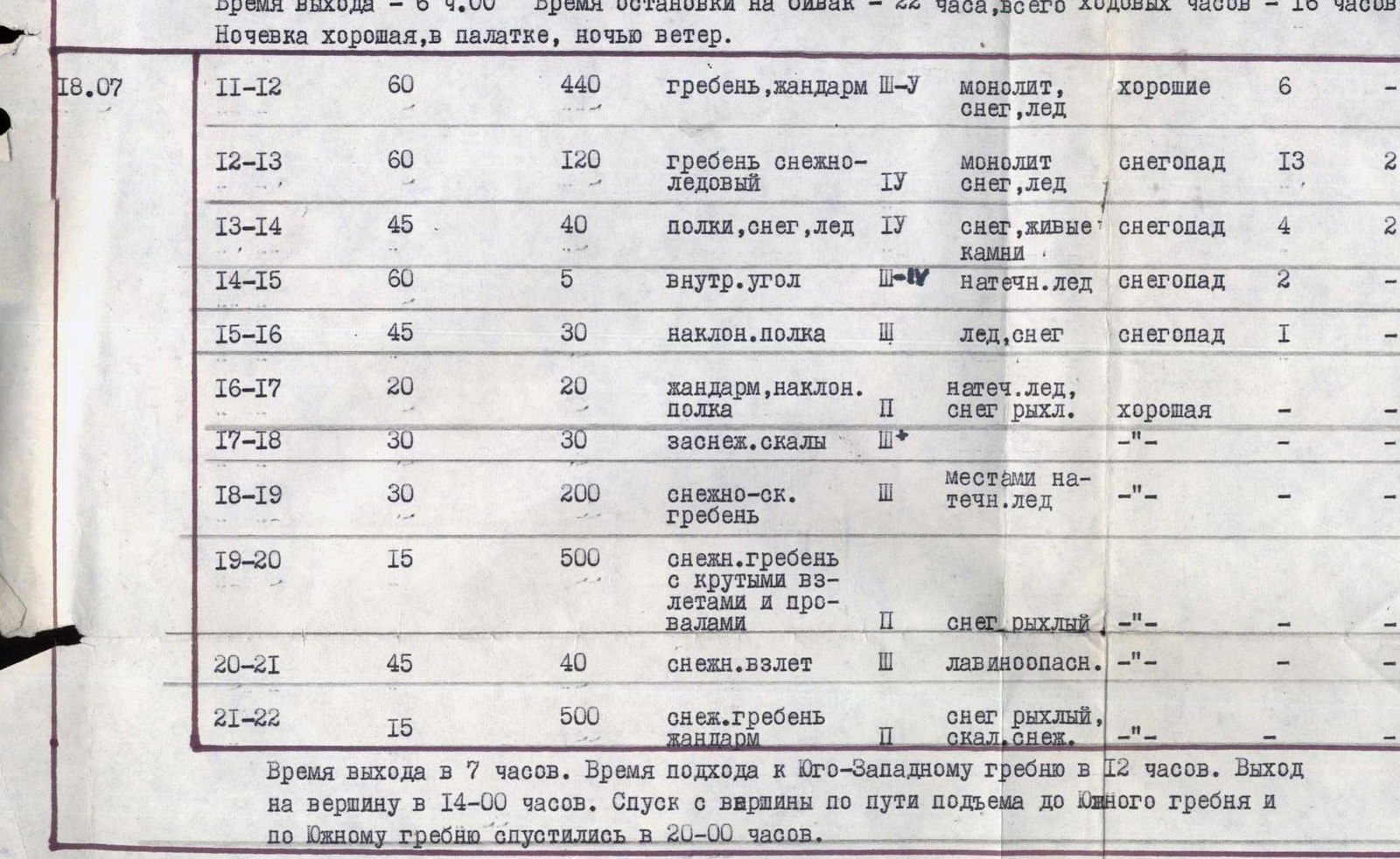
| 18.07 | R11–R12 | 60° | 440 m | ridge, sentry | 3–5 | monolith, snow, ice | good | 6 | - |
| R12–R13 | 60° | 120 m | snowy-icy ridge | 4 | monolith, snow, ice | snowfall | 13 | 2 | |
| R13–R14 | 45° | 40 m | ledges, snow, ice | 4 | snow, loose rocks | snowfall | 4 | 2 | |
| R14–R15 | 60° | 5 m | inner corner | 1–4 | flow ice | snowfall | 2 | - | |
| R15–R16 | 45° | 30 m | inclined ledge | 3 | ice, snow | snowfall | 1 | - | |
| R16–R17 | 20° | 20 m | sentry, inclined ledge | 2 | flow ice, loose snow | good | - | - | |
| R17–R18 | 30° | 30 m | snow-covered rocks | 3* | - | - | - | - | |
| R18–R19 | 30° | 200 m | snowy-rocky ridge | 3 | partly flow ice | -"- | - | - | |
| R19–R20 | 15° | 500 m | snowy ridge with steep ascents and dips | 2 | loose snow | -"- | - | - | |
| R20–R21 | 45° | 40 m | snowy ascent | 3 | avalanche-prone | -"- | - | - | |
| R21–R22 | 15° | 500 m | snowy ridge, sentry | 2 | loose snow, rocks, snow | -"- | - | - |
Departure time — 6:00. Time to stop for bivouac — 22:00. Total climbing hours — 16 h. Overnight stay was good, in a tent, windy at night. Departure time — at 7:00. Approach to the Southwest ridge — at 12:00. Reaching the summit — at 14:00. Descent from the summit via the ascent route to the South ridge and along the South ridge — at 20:00.
Section R5–R6, SW exposure.