Description of the Ascent Route to Obryv Peak via the Southeast Ridge (First Ascent)
Group members: Zhelonkin E.F. (leader), Khokhryakov G.P., Eliseev G.M., Kelikeldin G.V., Sofronov I.D.
Obryv Peak is located in the upper reaches of the Zeravshan Glacier, at the end of the southern spur of the Turkestan Range (Pamir-Alay).
To the north of Obryv Peak, within the same spur, lies an unnamed peak 5025, separated from Obryv Peak by a long, heavily dissected ridge. To the east, towards Matcha Pass, several steep ridges descend from Obryv Peak and its pre-summit ridges, separated by broad snow-and-ice couloirs.
Two ridges extend south and southeast from the peak, terminating in rock walls.
According to available data, Obryv Peak had not been climbed before. The route chosen for the first ascent was an ascent via the southeast ridge, accessing it from the southwest through a couloir.
The group from Arzamas-16, consisting of G.M. Eliseev, G.V. Kelikeldin, G.P. Khokhryakov, I.D. Sofronov, and E.F. Zhelonkin (leader), departed from the base camp at Matcha Pass at 6:00 on August 4, 1969, reached the summit the same day, spent the night on the ridge, and returned to camp at 14:00 on August 5, descending via the ascent route.
The route is a combination of rock, snow, and ice climbing. The main part of the route involves rock climbing, although there are difficult snow and ice sections.
From Matcha Pass, the path follows the Zeravshan Glacier, bypassing the southeast ridge to the southern slopes of Obryv Peak. A lake under the southern slopes serves as a landmark for the start of the ascent. Immediately beyond the lake, the ascent proceeds through talus onto a snowfield. The path goes up a fairly steep snowfield to the right, reaching its upper part and emerging onto rocks.
Rock climbing of moderate difficulty ensues, moving left upwards. Inclined ledges alternate with 2–3-meter walls. The next landmark is a set of smooth, overhanging rocks that are bypassed on the right via rocks of moderate difficulty. As one approaches these rocks (after 70–100 meters), the steepness increases, necessitating a move to the right and upwards. Progress is made with alternate protection through outcrops.
After ascending 80–100 meters, it's more convenient to move left and upwards to a steep tongue of a large snowfield. The distance to it is about 60–80 meters. The steep snowy tongue is ascended to reach a large snowfield. From there, the path continues straight up the snow to the edge of a steep couloir with sheer, high sides, which extends to the right and upwards. The lower edge of the couloir is a jumble of rocks that drop steeply into the couloir. A safe path lies along the right side of the couloir. This section is traversed simultaneously, with the rope anchored to outcrops.
In its upper part, the rocky edge of the couloir is heavily dissected, forming many high, pointed rock pinnacles. Continuing along the edge of the couloir becomes inconvenient and hazardous. There is a suitable spot to descend into the couloir onto snow, where it bifurcates.
The path follows the snow in the right (orographically) couloir, which gradually transitions into a fairly steep and narrow groove, 15–20 meters long. This groove leads out onto the ridge.
At this point on the ridge, there's a fairly large snow platform, an excellent spot for camping. A control cairn is located here.
A 5–7-meter rock wall is overcome. Further, the rocky ridge leads to a second small shoulder. It's possible to traverse not directly along the ridge but along the edge of a very steep snowfield descending from the ridge, requiring great caution and proximity to the rocks.
From the second shoulder, the path to the summit ridge is blocked by a gendarme. Up to about halfway up the gendarme, there's a very steep snowfield. It's dangerous to ascend directly up this snowfield due to its steepness and lack of snow. A viable path exists along the fairly broken rocks to the left of the snowfield.
At the level of the upper part of the snowfield, there's a fairly wide horizontal ledge, along which the gendarme is traversed to the right. This ledge ends at an 8–10-meter wall, which, once overcome (with protection via a piton), leads onto the edge—a steep snow-and-ice couloir that exits onto the summit ridge.
In the upper part of the couloir, there's a rocky outcrop. The path to the summit ridge is possible via this couloir. From the edge, one transitions onto the rocky outcrop, necessitating the traversal (with protection) of a steep ice wall with rocks frozen into it.
From the edge to the rocky outcrop is 40 meters. An ice screw is placed for intermediate protection. The path then continues along the right edge of the rocky outcrop (another 40 meters). After the rocky outcrop, the path proceeds up steep, deep snow, leading into a gap between the first and second gendarmes.
The path along the ridge is blocked by a sheer, smooth rock wall of the second gendarme. The gendarme is bypassed on the right.
Then, via fairly difficult rocks, the path moves to the right and upwards, emerging onto the summit ridge. From here, the path to the summit is straightforward and follows the ridge.
The ridge has no large gaps but is quite jagged. It drops away on the left with a wall and has overhanging snow cornices on the right. Alternate protection through outcrops and folds is necessary here.
The summit is a rise in the ridge with a huge snow cornice. There's a spot to set up a tent. A control cairn is located at the summit.
A summary of the route's characteristics and timeline is provided in the table.
Possible camping spots on the route:
- on the first shoulder of the ridge,
- at the summit.
In assessing the difficulty category of the route, the group drew upon their experience with classified routes of the 4th category of difficulty. This route is technically more challenging than routes to:
- the 1st tower of Korona (4A category, Kyrgyz Ala-Too),
- Suvaryk (4A category, Baksan),
- Dvurogaya (4B category, Kyrgyz Ala-Too),
- Galdor Glavny from the West (4B category, Digoria).
Based on this, the group proposes categorizing the ascent to Obryv Peak via the southeast ridge as a 4B category route.
Appendix: Recommended equipment for a group of 4.
- Ropes 40 m — 2
- Set of rock pitons — 15
- Ice screws — 2
- Hammers — 2
- Pamir-style tent — 1
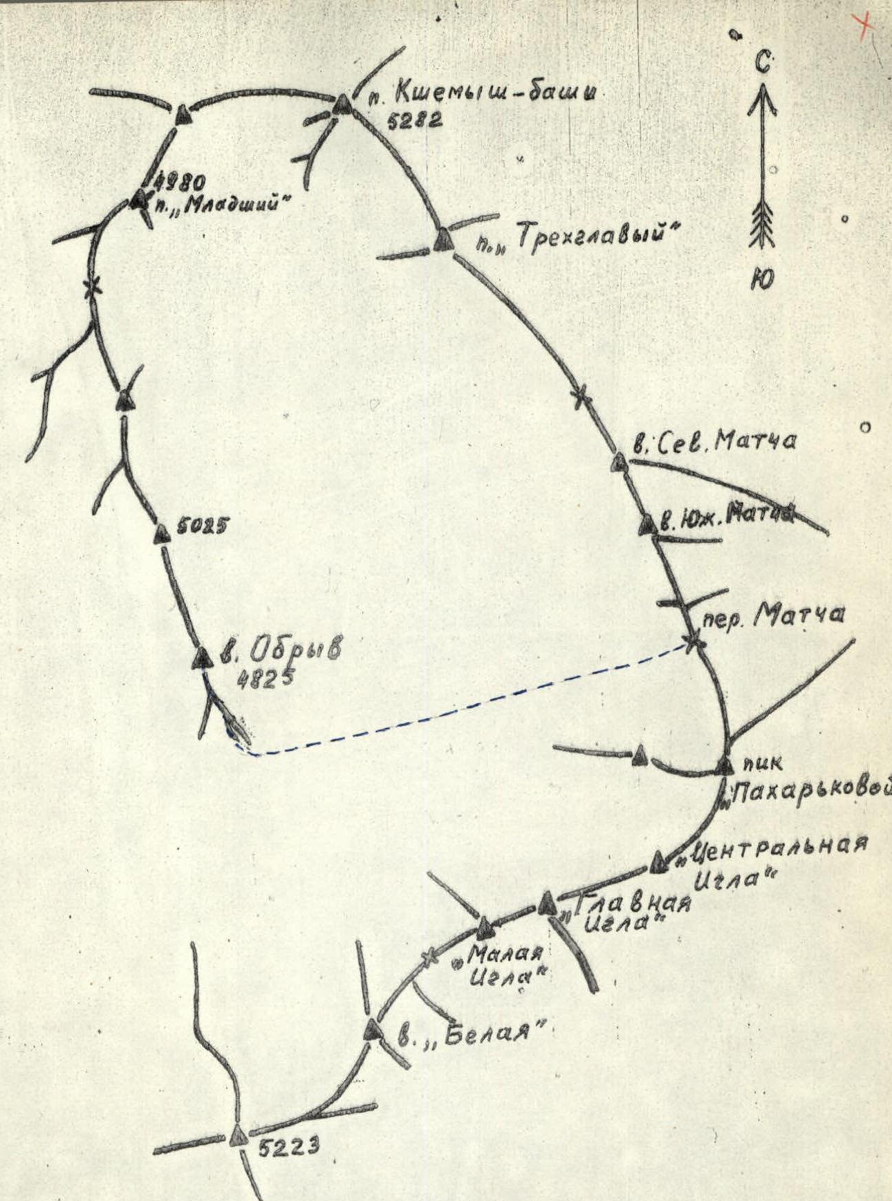
Fig. 3. Schematic of the ridges in the upper reaches of the Zeravshan Glacier
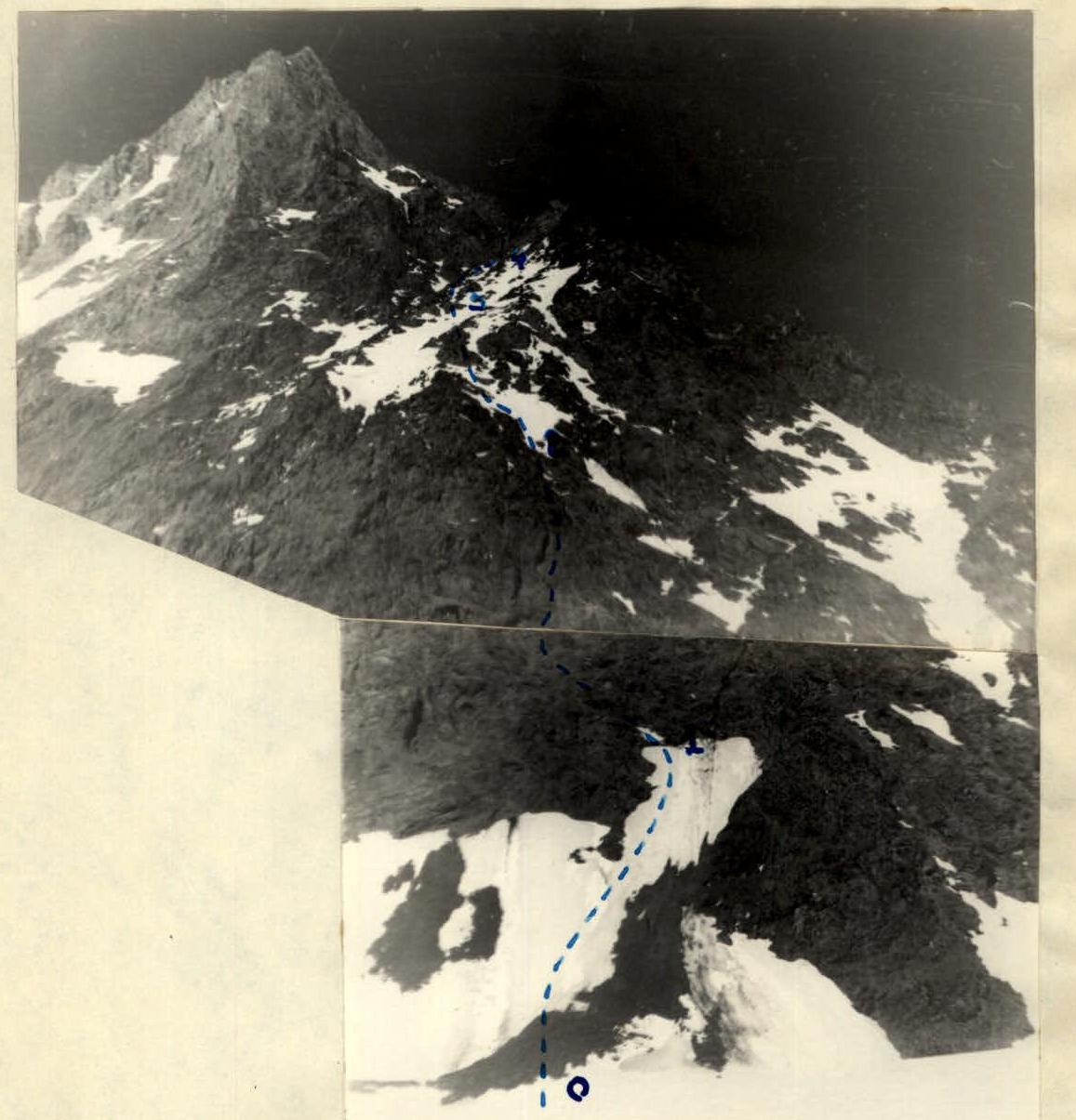
Start of the route to Obryv Peak. View from the southwest.
Upper part of the route to Obryv Peak. View from the east.
Obryv Peak.
TABLE OF MAIN CHARACTERISTICS OF THE ASCENT ROUTE TO OBRYV PEAK VIA THE SOUTHEAST RIDGE
| Time | Walking Hours | Section Covered | Average Steepness | Vertical Distance Covered | Weather Conditions | Section Characteristics | Technical Difficulty | Protection Method | Pitons Used |
|---|---|---|---|---|---|---|---|---|---|
| By Terrain Nature | |||||||||
| 1 | 2 | 3 | 4 | 5 | 6 | 7 | 8 | 9 | 10 |
| 6:00 | 0.5 | R0–R1 | 35° | 100 m | Good | Upwards to the right. Steep, dense firn. | Simple | Simultaneous movement | - |
| 1.5 | R1–R2 | 50° | 350 m | Good | Left and upwards to overhanging rocks. Inclined ledges alternate with 2–3-meter walls. Many loose rocks. Overhanging rocks are bypassed on the right. Then, via rocks of similar difficulty, left and upwards to snow. | Medium and above medium difficulty | Alternate movement. Protection via outcrops and pitons | 3 rock pitons | |
| 0.5 | R2–R3 | 30° | 50 m | Good | Straight up. Steep, deep snow. Bypass rocky outcrops. Exit onto a rocky ridge (edge of a large couloir) going up to the right. | Medium difficulty | Simultaneous movement. Occasionally alternate with ice axe protection. | - | |
| 1 | R3–R4 | 45° | 100 m | Good | Rocky ridge going up to the right. Rocks are heavily broken. Many loose rocks. | Above medium difficulty | Alternate movement. Protection via outcrops and folds. | - | |
| 0.5 | R4–R5 | 50° | 50 m | Good | Descent into the couloir. Steep snow in the couloir. Steep rocky groove. General direction up to the right onto the ridge shoulder. | Above medium difficulty | Alternate movement on snow. Protection via ice axe. In the groove, protection via piton. | 1 rock piton | |
| 0.5 | R5–R6 | 45° | 100 m | Good | Movement along the ridge. Steep 5–7-meter rock wall. Movement along the edge of a snowfield. | Above medium difficulty | Alternate movement. Via outcrops, ice axe | - | |
| 0.5 | R6–R7 | 60° | 50 m | Good | Straight up. Very steep. Rocks heavily broken. Many loose rocks. | Medium and above medium difficulty | Alternate movement. Protection via outcrops. | - | |
| 0.5 | R7–R8 | 0° — ledge, 70°–80° — wall | 30 m | Good | Fairly wide ledge to the right. Then a steep 8–10-meter wall. | Easy on the ledge, above medium difficulty on the wall | Alternate movement. Wall overcome with piton protection. | 2 rock pitons | |
| 2 | R8–R9 | 60°–70° | 100 m | Good | Up the couloir. Couloir is icy in the lower part. Rocky outcrop in the upper part. Steep, deep snow in the upper part. | Above medium difficulty. Very difficult (ice wall) | Alternate movement via ice screw. Rock piton. | 1 ice screw, 1 rock piton. | |
| 0.5 | R9–R10 | 50 m | Good | Bypass wall on the right, emerging up onto the ridge. Rocks are large, monolithic blocks. Smooth slabs. | Above medium difficulty | Alternate movement. Protection via outcrops. | - | ||
| 1 | R10–R11 | 100 m | Good | Heavily dissected ridge. Drops away on the left with a rock wall. Snow cornices on the right. Many 1.5–2.5-meter walls traversed directly. | Above medium and difficult climbing | Alternate movement. Protection via outcrops and folds. | - |
Total 11 hours (average steepness)